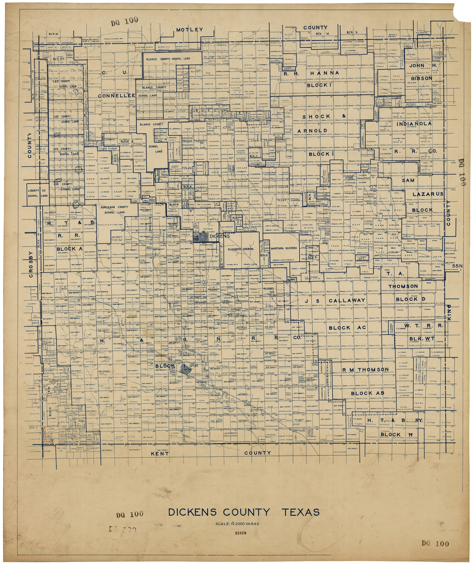
Dickens County, Texas
DQ100
-
Map/Doc
92588
-
Collection
Twichell Survey Records
-
Counties
Dickens
-
Subjects
County
-
Height x Width
33.7 x 39.8 inches
85.6 x 101.1 cm
Part of: Twichell Survey Records
Lamb-Bailey County Line

Print $40.00
- Digital $50.00
Lamb-Bailey County Line
Size 15.9 x 53.3 inches
Map/Doc 89671
N. C. Payne Land in Lamb and Hale Counties]
![91060, N. C. Payne Land in Lamb and Hale Counties], Twichell Survey Records](https://historictexasmaps.com/wmedia_w700/maps/91060-1.tif.jpg)
Print $20.00
- Digital $50.00
N. C. Payne Land in Lamb and Hale Counties]
Size 18.6 x 23.9 inches
Map/Doc 91060
City of Slaton, Lubbock County, Texas

Print $40.00
- Digital $50.00
City of Slaton, Lubbock County, Texas
Size 51.4 x 41.3 inches
Map/Doc 89897
[Sections 61-65, I. & G. N. Block 1 and part of Block 194]
![91678, [Sections 61-65, I. & G. N. Block 1 and part of Block 194], Twichell Survey Records](https://historictexasmaps.com/wmedia_w700/maps/91678-1.tif.jpg)
Print $20.00
- Digital $50.00
[Sections 61-65, I. & G. N. Block 1 and part of Block 194]
Size 24.9 x 17.3 inches
Map/Doc 91678
[Connection to Block M-6 and west Castro and Swisher]
![93041, [Connection to Block M-6 and west Castro and Swisher], Twichell Survey Records](https://historictexasmaps.com/wmedia_w700/maps/93041-1.tif.jpg)
Print $40.00
- Digital $50.00
[Connection to Block M-6 and west Castro and Swisher]
Size 60.9 x 28.3 inches
Map/Doc 93041
Map of Texas-Mexican Railway Lands in El Paso County, Texas

Print $3.00
- Digital $50.00
Map of Texas-Mexican Railway Lands in El Paso County, Texas
1907
Size 13.7 x 10.8 inches
Map/Doc 91134
Amended Plat New Hobbs Addition to New Hobbs, Lea County, New Mexico

Print $20.00
- Digital $50.00
Amended Plat New Hobbs Addition to New Hobbs, Lea County, New Mexico
Size 24.1 x 18.5 inches
Map/Doc 92418
Jeff Davis Co.

Print $20.00
- Digital $50.00
Jeff Davis Co.
1915
Size 26.0 x 28.0 inches
Map/Doc 92174
[Map Showing Distances from Marshall]
![89908, [Map Showing Distances from Marshall], Twichell Survey Records](https://historictexasmaps.com/wmedia_w700/maps/89908-1.tif.jpg)
Print $40.00
- Digital $50.00
[Map Showing Distances from Marshall]
Size 45.0 x 51.4 inches
Map/Doc 89908
Conoco Official Road Map New Mexico

Print $20.00
- Digital $50.00
Conoco Official Road Map New Mexico
1934
Size 18.5 x 24.4 inches
Map/Doc 92436
Whitharral Located on West Half of Labor 11, Capitol League 716 Hockley County, Texas

Print $20.00
- Digital $50.00
Whitharral Located on West Half of Labor 11, Capitol League 716 Hockley County, Texas
Size 17.5 x 20.9 inches
Map/Doc 92261
[Sketch showing part of H. & G. N. Block 1]
![89633, [Sketch showing part of H. & G. N. Block 1], Twichell Survey Records](https://historictexasmaps.com/wmedia_w700/maps/89633-1.tif.jpg)
Print $40.00
- Digital $50.00
[Sketch showing part of H. & G. N. Block 1]
Size 20.0 x 54.4 inches
Map/Doc 89633
You may also like
[Sections 94 and 826-831 along Red River]
![93161, [Sections 94 and 826-831 along Red River], Twichell Survey Records](https://historictexasmaps.com/wmedia_w700/maps/93161-1.tif.jpg)
Print $40.00
- Digital $50.00
[Sections 94 and 826-831 along Red River]
Size 43.2 x 111.4 inches
Map/Doc 93161
Eleven County Map

Print $40.00
- Digital $50.00
Eleven County Map
Size 39.2 x 57.5 inches
Map/Doc 89856
Presidio County Rolled Sketch 82

Print $20.00
- Digital $50.00
Presidio County Rolled Sketch 82
1943
Size 35.5 x 26.1 inches
Map/Doc 7369
Nueces County NRC Article 33.136 Sketch 12

Print $80.00
- Digital $50.00
Nueces County NRC Article 33.136 Sketch 12
2000
Size 24.9 x 36.7 inches
Map/Doc 83065
Brooks County Sketch File 11

Print $14.00
- Digital $50.00
Brooks County Sketch File 11
Size 11.3 x 8.9 inches
Map/Doc 16573
Stephens County Working Sketch 20

Print $20.00
- Digital $50.00
Stephens County Working Sketch 20
1972
Size 26.7 x 30.6 inches
Map/Doc 63963
Baylor County Sketch File 14

Print $4.00
- Digital $50.00
Baylor County Sketch File 14
1879
Size 13.0 x 8.2 inches
Map/Doc 14181
Terrell County Working Sketch 65

Print $40.00
- Digital $50.00
Terrell County Working Sketch 65
1972
Size 49.0 x 44.8 inches
Map/Doc 69586
Crockett County Working Sketch 53

Print $20.00
- Digital $50.00
Crockett County Working Sketch 53
1948
Size 24.2 x 27.7 inches
Map/Doc 68386
The Republic County of Austin. Defined, May 24, 1838

Print $20.00
The Republic County of Austin. Defined, May 24, 1838
2020
Size 14.7 x 21.6 inches
Map/Doc 96082
Flight Mission No. CRK-3P, Frame 66, Refugio County

Print $20.00
- Digital $50.00
Flight Mission No. CRK-3P, Frame 66, Refugio County
1956
Size 18.6 x 22.4 inches
Map/Doc 86908
Railroad Track Map, T&PRRCo., Culberson County, Texas

Print $4.00
- Digital $50.00
Railroad Track Map, T&PRRCo., Culberson County, Texas
1910
Size 11.8 x 18.5 inches
Map/Doc 62827