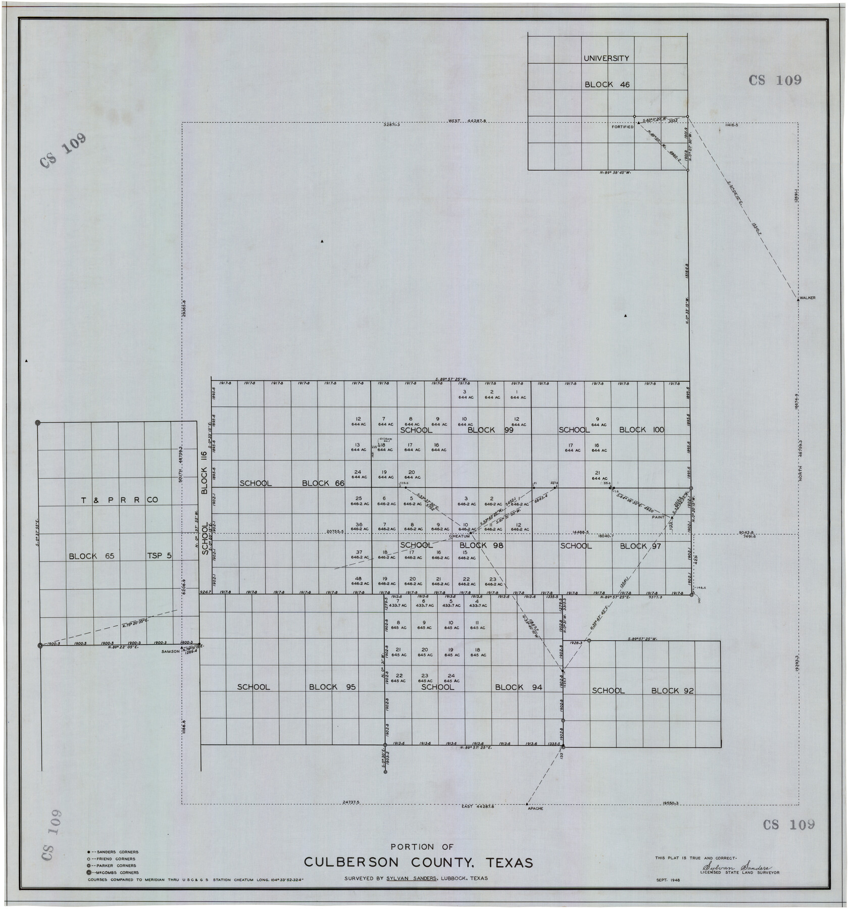
Portion of Culberson County, Texas
CS109
-
Map/Doc
92609
-
Collection
Twichell Survey Records
-
Object Dates
9/1948 (Creation Date)
-
People and Organizations
Sylvan Sanders (Surveyor/Engineer)
-
Counties
Culberson
-
Height x Width
31.1 x 33.2 inches
79.0 x 84.3 cm
Part of: Twichell Survey Records
[Worksheets related to the Wilson Strickland survey and vicinity]
![89714, [Vicinity and related to the Wilson Strickland Survey], Twichell Survey Records](https://historictexasmaps.com/wmedia_w700/maps/89714-1.tif.jpg)
Print $20.00
- Digital $50.00
[Worksheets related to the Wilson Strickland survey and vicinity]
Size 40.9 x 43.1 inches
Map/Doc 89714
[Subdivision surveys of the McCutcheon League near the Bastrop-Caldwell County Line]
![90148, [Subdivision surveys of the McCutcheon League near the Bastrop-Caldwell County Line], Twichell Survey Records](https://historictexasmaps.com/wmedia_w700/maps/90148-1.tif.jpg)
Print $20.00
- Digital $50.00
[Subdivision surveys of the McCutcheon League near the Bastrop-Caldwell County Line]
1923
Size 12.5 x 16.9 inches
Map/Doc 90148
[Southwest part of B. S. & F. Block and surveys to the south]
![90389, [Southwest part of B. S. & F. Block and surveys to the south], Twichell Survey Records](https://historictexasmaps.com/wmedia_w700/maps/90389-1.tif.jpg)
Print $3.00
- Digital $50.00
[Southwest part of B. S. & F. Block and surveys to the south]
Size 11.1 x 10.3 inches
Map/Doc 90389
[H. & T. C. RR. Company, Block 47, Sections 16- 28]
![91248, [H. & T. C. RR. Company, Block 47, Sections 16- 28], Twichell Survey Records](https://historictexasmaps.com/wmedia_w700/maps/91248-1.tif.jpg)
Print $20.00
- Digital $50.00
[H. & T. C. RR. Company, Block 47, Sections 16- 28]
Size 30.4 x 21.6 inches
Map/Doc 91248

Plat of Connecting Line between Northwest Corner of Eddy Sparks 1-1662

Print $20.00
- Digital $50.00
Plat of Connecting Line between Northwest Corner of Eddy Sparks 1-1662
1945
Size 20.0 x 27.6 inches
Map/Doc 92602
[Sketch of Part of B. S. & F. Block 9]
![93088, [Sketch of Part of B. S. & F. Block 9], Twichell Survey Records](https://historictexasmaps.com/wmedia_w700/maps/93088-1.tif.jpg)
Print $2.00
- Digital $50.00
[Sketch of Part of B. S. & F. Block 9]
Size 8.0 x 7.9 inches
Map/Doc 93088
[E. L. & R. R. Block E, Showing Mound Lake]
![91335, [E. L. & R. R. Block E, Showing Mound Lake], Twichell Survey Records](https://historictexasmaps.com/wmedia_w700/maps/91335-1.tif.jpg)
Print $2.00
- Digital $50.00
[E. L. & R. R. Block E, Showing Mound Lake]
Size 14.8 x 6.3 inches
Map/Doc 91335
[Notes and map showing Public School Land Block K between Yoakum and Terry Counties]
![92011, [Notes and map showing Public School Land Block K between Yoakum and Terry Counties], Twichell Survey Records](https://historictexasmaps.com/wmedia_w700/maps/92011-1.tif.jpg)
Print $20.00
- Digital $50.00
[Notes and map showing Public School Land Block K between Yoakum and Terry Counties]
1902
Size 17.1 x 30.9 inches
Map/Doc 92011
[Plat showing Blocks Z, Q and D]
![90289, [Plat showing Blocks Z, Q and D], Twichell Survey Records](https://historictexasmaps.com/wmedia_w700/maps/90289-1.tif.jpg)
Print $20.00
- Digital $50.00
[Plat showing Blocks Z, Q and D]
Size 15.9 x 21.2 inches
Map/Doc 90289
Working Sketch in Archer County

Print $20.00
- Digital $50.00
Working Sketch in Archer County
1924
Size 30.3 x 42.2 inches
Map/Doc 90171
[Surveys South of Levi Pruitt and Jno. Welch]
![92091, [Surveys South of Levi Pruitt and Jno. Welch], Twichell Survey Records](https://historictexasmaps.com/wmedia_w700/maps/92091-1.tif.jpg)
Print $20.00
- Digital $50.00
[Surveys South of Levi Pruitt and Jno. Welch]
Size 18.2 x 6.3 inches
Map/Doc 92091
You may also like
Shackelford County Sketch File 5

Print $4.00
- Digital $50.00
Shackelford County Sketch File 5
1885
Size 12.3 x 7.6 inches
Map/Doc 36578
Flight Mission No. CUG-3P, Frame 16, Kleberg County

Print $20.00
- Digital $50.00
Flight Mission No. CUG-3P, Frame 16, Kleberg County
1956
Size 18.3 x 22.2 inches
Map/Doc 86226
Plano General de la Ciudad de Mexico. Levantado Por el Teniente Coronel Don Diego Garcia Conde en el Año de 1793. Aumentado y corregido en lo mas notable Por el Teniente Coronel retirado, Don Rafael Maria Calvo En el de 1830

Print $20.00
- Digital $50.00
Plano General de la Ciudad de Mexico. Levantado Por el Teniente Coronel Don Diego Garcia Conde en el Año de 1793. Aumentado y corregido en lo mas notable Por el Teniente Coronel retirado, Don Rafael Maria Calvo En el de 1830
1793
Size 19.7 x 21.8 inches
Map/Doc 95354
Erath County Working Sketch 10

Print $20.00
- Digital $50.00
Erath County Working Sketch 10
1948
Size 28.7 x 24.5 inches
Map/Doc 69091
Reeves County Working Sketch 50

Print $20.00
- Digital $50.00
Reeves County Working Sketch 50
1974
Size 45.3 x 30.4 inches
Map/Doc 63493
Map Prepared from Data by Original Field Book by W.D. Twichell

Print $40.00
- Digital $50.00
Map Prepared from Data by Original Field Book by W.D. Twichell
Size 64.0 x 40.0 inches
Map/Doc 89733
Angelina County Sketch File 15g

Print $4.00
- Digital $50.00
Angelina County Sketch File 15g
1882
Size 10.9 x 8.4 inches
Map/Doc 12996

Map of Texas Containing the Latest Grants and Discoveries

Print $20.00
Map of Texas Containing the Latest Grants and Discoveries
1836
Size 16.2 x 10.6 inches
Map/Doc 76245
Maps & Lists Showing Prison Lands (Oil & Gas) Leased as of June 1955

Digital $50.00
Maps & Lists Showing Prison Lands (Oil & Gas) Leased as of June 1955
1934
Size 30.2 x 35.2 inches
Map/Doc 62877
Little River, Cameron Sheet

Print $4.00
- Digital $50.00
Little River, Cameron Sheet
1914
Size 28.3 x 24.4 inches
Map/Doc 65062
Dickens County

Print $20.00
- Digital $50.00
Dickens County
1895
Size 22.8 x 18.7 inches
Map/Doc 3484