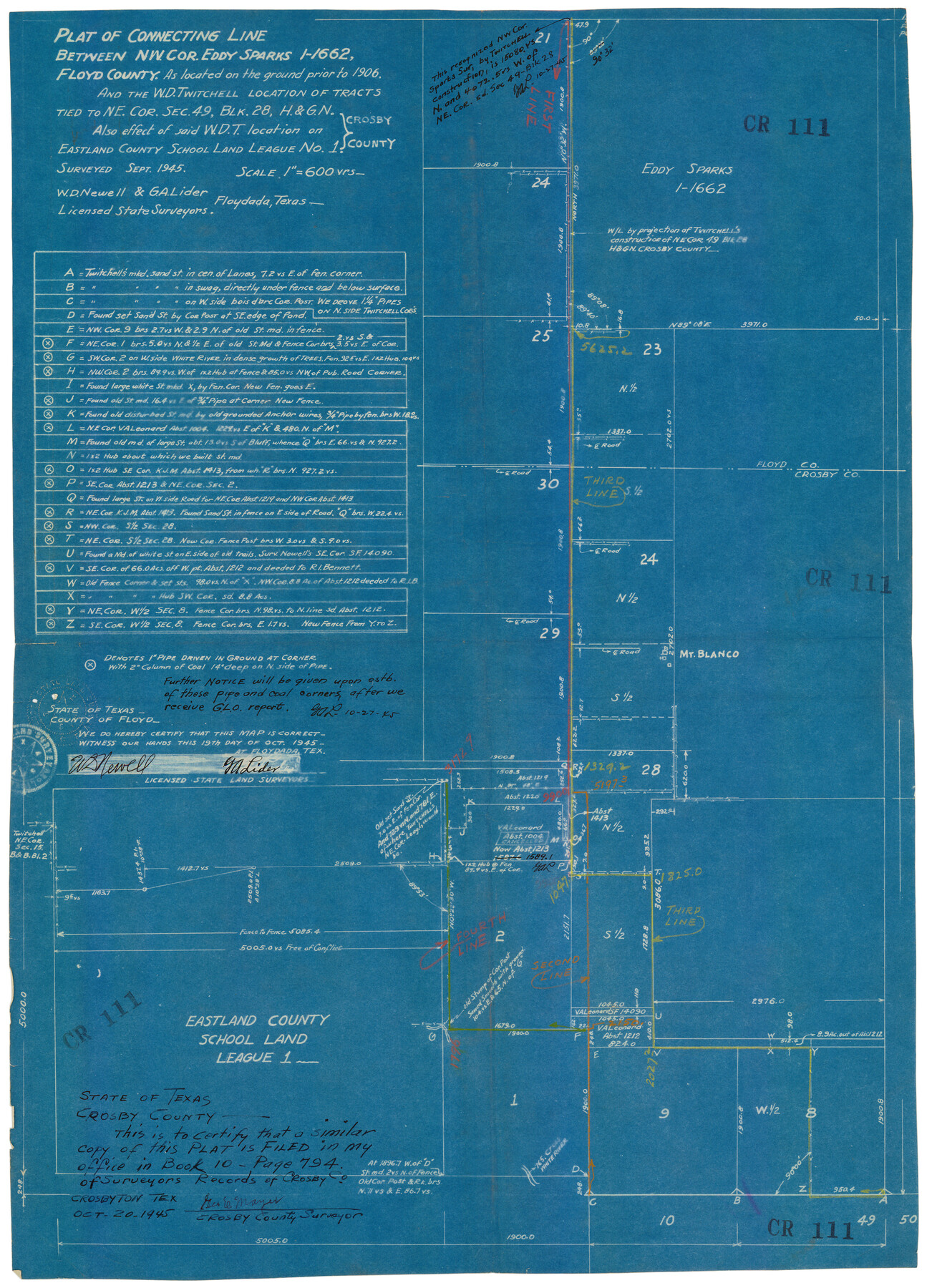
Plat of Connecting Line between Northwest Corner of Eddy Sparks 1-1662
CR111
-
Map/Doc
92602
-
Collection
Twichell Survey Records
-
Object Dates
1945 (Creation Date)
-
Counties
Crosby
-
Height x Width
20.0 x 27.6 inches
50.8 x 70.1 cm
Part of: Twichell Survey Records
Sketch in Gaines and Dawson Counties

Print $20.00
- Digital $50.00
Sketch in Gaines and Dawson Counties
1950
Size 16.0 x 31.3 inches
Map/Doc 92586
[Block 1 and vicinity]
![90703, [Block 1 and vicinity], Twichell Survey Records](https://historictexasmaps.com/wmedia_w700/maps/90703-1.tif.jpg)
Print $20.00
- Digital $50.00
[Block 1 and vicinity]
Size 25.3 x 24.1 inches
Map/Doc 90703
Lands of C. W. Post in Garza and Lynn Counties, Tex. and Surrounding Lands

Print $20.00
- Digital $50.00
Lands of C. W. Post in Garza and Lynn Counties, Tex. and Surrounding Lands
1913
Size 15.8 x 18.0 inches
Map/Doc 90851
Clayton Carter Addition, North 84.9 Acres of Section 77, Block A

Print $20.00
- Digital $50.00
Clayton Carter Addition, North 84.9 Acres of Section 77, Block A
1945
Size 30.1 x 9.6 inches
Map/Doc 92767
Working Sketch in Randall and Swisher Cos.

Print $20.00
- Digital $50.00
Working Sketch in Randall and Swisher Cos.
1917
Size 14.6 x 36.3 inches
Map/Doc 93048
Block 1 H&GN RR Co.

Print $20.00
- Digital $50.00
Block 1 H&GN RR Co.
Size 39.3 x 40.3 inches
Map/Doc 89769
Parkland Place, An Addition to Muleshoe

Print $20.00
- Digital $50.00
Parkland Place, An Addition to Muleshoe
1955
Size 39.2 x 30.3 inches
Map/Doc 92531
[T. C. & S. F. Block K11, Capitol Leagues 367, 373, 374, and Blocks D and B]
![90536, [T. C. & S. F. Block K11, Capitol Leagues 367, 373, 374, and Blocks D and B], Twichell Survey Records](https://historictexasmaps.com/wmedia_w700/maps/90536-1.tif.jpg)
Print $3.00
- Digital $50.00
[T. C. & S. F. Block K11, Capitol Leagues 367, 373, 374, and Blocks D and B]
1903
Size 9.5 x 13.7 inches
Map/Doc 90536
Parkland Place

Print $20.00
- Digital $50.00
Parkland Place
1928
Size 15.9 x 13.0 inches
Map/Doc 92278
Arizona Chemical Co. Brownfield Plant

Print $20.00
- Digital $50.00
Arizona Chemical Co. Brownfield Plant
Size 28.3 x 19.9 inches
Map/Doc 92892
[Portion of Blk. D-19 & H. & O. B. Blk. 1]
![90352, [Portion of Blk. D-19 & H. & O. B. Blk. 1], Twichell Survey Records](https://historictexasmaps.com/wmedia_w700/maps/90352-1.tif.jpg)
Print $3.00
- Digital $50.00
[Portion of Blk. D-19 & H. & O. B. Blk. 1]
Size 13.9 x 10.1 inches
Map/Doc 90352
Map Showing the Location of Murray Farms

Print $20.00
- Digital $50.00
Map Showing the Location of Murray Farms
Size 13.6 x 17.7 inches
Map/Doc 92832
You may also like
Brazoria County Working Sketch 21

Print $20.00
- Digital $50.00
Brazoria County Working Sketch 21
1954
Size 41.5 x 41.8 inches
Map/Doc 67506
Galveston County Sketch File 29

Print $40.00
- Digital $50.00
Galveston County Sketch File 29
Size 35.1 x 29.3 inches
Map/Doc 10454
Randall County Sketch File 7

Print $14.00
- Digital $50.00
Randall County Sketch File 7
1931
Size 7.3 x 8.9 inches
Map/Doc 34963

Flight Mission No. DCL-6C, Frame 93, Kenedy County

Print $20.00
- Digital $50.00
Flight Mission No. DCL-6C, Frame 93, Kenedy County
1943
Size 18.6 x 22.3 inches
Map/Doc 85923
Hardeman County Working Sketch 11

Print $40.00
- Digital $50.00
Hardeman County Working Sketch 11
1960
Size 40.0 x 58.1 inches
Map/Doc 63392
Jack County Boundary File 1a

Print $16.00
- Digital $50.00
Jack County Boundary File 1a
Size 10.7 x 8.4 inches
Map/Doc 55376
Marion County Rolled Sketch F

Print $40.00
- Digital $50.00
Marion County Rolled Sketch F
1937
Size 43.5 x 67.1 inches
Map/Doc 9487
Flight Mission No. BRA-16M, Frame 50, Jefferson County

Print $20.00
- Digital $50.00
Flight Mission No. BRA-16M, Frame 50, Jefferson County
1953
Size 18.5 x 22.5 inches
Map/Doc 85667
Flight Mission No. BRA-3M, Frame 128, Jefferson County

Print $20.00
- Digital $50.00
Flight Mission No. BRA-3M, Frame 128, Jefferson County
1953
Size 18.5 x 22.3 inches
Map/Doc 85402
Flight Mission No. DQO-8K, Frame 71, Galveston County

Print $20.00
- Digital $50.00
Flight Mission No. DQO-8K, Frame 71, Galveston County
1952
Size 18.6 x 22.4 inches
Map/Doc 85175
Aransas County Rolled Sketch 27F
Print $20.00
- Digital $50.00
Aransas County Rolled Sketch 27F
1982
Size 32.6 x 33.0 inches
Map/Doc 8420