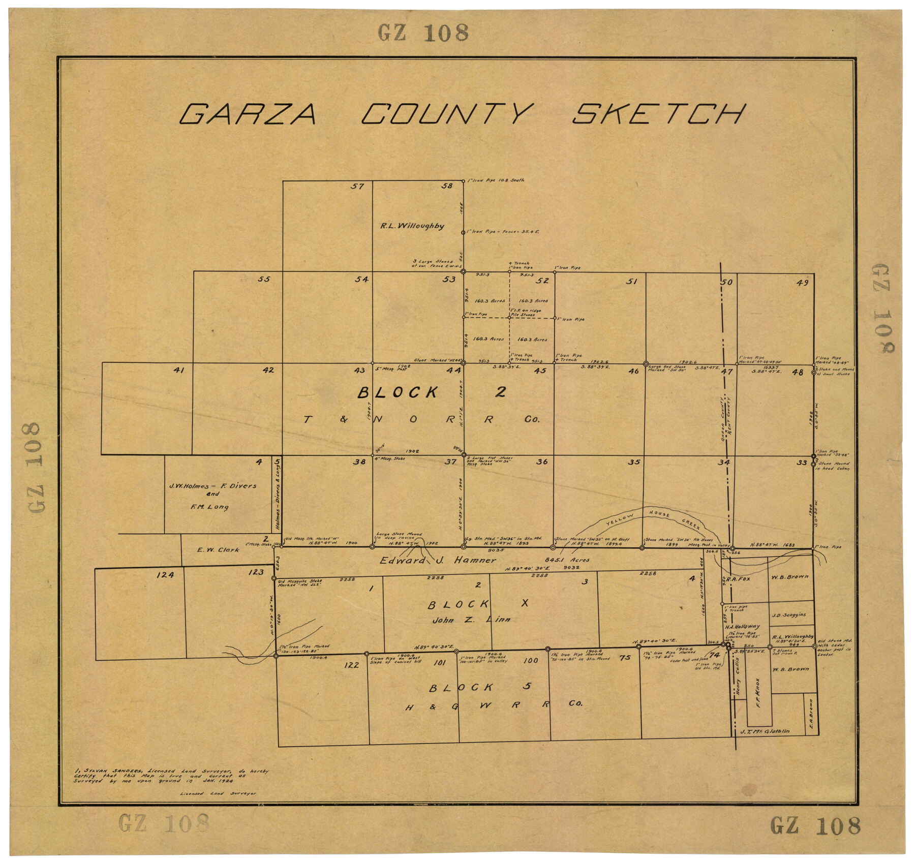
Garza County Sketch
GZ108
-
Map/Doc
92701
-
Collection
Twichell Survey Records
-
Object Dates
1/1924 (Creation Date)
-
People and Organizations
Sylvan Sanders (Surveyor/Engineer)
-
Counties
Garza
-
Height x Width
19.6 x 18.4 inches
49.8 x 46.7 cm
Part of: Twichell Survey Records
Map of the Capitol Land Reservation

Print $20.00
- Digital $50.00
Map of the Capitol Land Reservation
Size 25.4 x 24.3 inches
Map/Doc 90642
T. C. Ivey Ranch, Block D, Yoakum Co., Texas

Print $20.00
- Digital $50.00
T. C. Ivey Ranch, Block D, Yoakum Co., Texas
Size 17.1 x 14.6 inches
Map/Doc 91976

[Lamb County Sketch File C]
![91193, [Lamb County Sketch File C], Twichell Survey Records](https://historictexasmaps.com/wmedia_w700/maps/91193-1.tif.jpg)
Print $20.00
- Digital $50.00
[Lamb County Sketch File C]
1904
Size 20.1 x 27.2 inches
Map/Doc 91193
[Map showing J. H. Gibson Block D]
![92016, [Map showing J. H. Gibson Block D], Twichell Survey Records](https://historictexasmaps.com/wmedia_w700/maps/92016-1.tif.jpg)
Print $20.00
- Digital $50.00
[Map showing J. H. Gibson Block D]
Size 17.8 x 15.1 inches
Map/Doc 92016
[Land on East Side of Creek, Exhibit G]
![91372, [Land on East Side of Creek, Exhibit G], Twichell Survey Records](https://historictexasmaps.com/wmedia_w700/maps/91372-1.tif.jpg)
Print $20.00
- Digital $50.00
[Land on East Side of Creek, Exhibit G]
Size 19.4 x 29.6 inches
Map/Doc 91372
Map of Block 1, H. & G. N. RR. Co.

Print $20.00
- Digital $50.00
Map of Block 1, H. & G. N. RR. Co.
1908
Size 26.3 x 32.0 inches
Map/Doc 90899
Working Sketch in Eastland Co.

Print $20.00
- Digital $50.00
Working Sketch in Eastland Co.
1918
Size 12.2 x 17.1 inches
Map/Doc 90881

Utility Map, Low Rent Housing Project Texas 18-1, Housing Authority of the City of Lubbock (Plan No. 3)

Print $20.00
- Digital $50.00
Utility Map, Low Rent Housing Project Texas 18-1, Housing Authority of the City of Lubbock (Plan No. 3)
1941
Size 42.5 x 27.3 inches
Map/Doc 92758
[River Sections 54-73, part of Blk. GG]
![90317, [River Sections 54-73, part of Blk. GG], Twichell Survey Records](https://historictexasmaps.com/wmedia_w700/maps/90317-1.tif.jpg)
Print $20.00
- Digital $50.00
[River Sections 54-73, part of Blk. GG]
Size 37.0 x 35.9 inches
Map/Doc 90317
[Coleman and McCullogh County Drilling Block]
![92968, [Coleman and McCullogh County Drilling Block], Twichell Survey Records](https://historictexasmaps.com/wmedia_w700/maps/92968-1.tif.jpg)
Print $20.00
- Digital $50.00
[Coleman and McCullogh County Drilling Block]
Size 16.6 x 18.6 inches
Map/Doc 92968
You may also like

Flight Mission No. CGI-1N, Frame 166, Cameron County

Print $20.00
- Digital $50.00
Flight Mission No. CGI-1N, Frame 166, Cameron County
1955
Size 18.5 x 22.2 inches
Map/Doc 84501
Railroad Track Map, H&TCRRCo., Falls County, Texas

Print $4.00
- Digital $50.00
Railroad Track Map, H&TCRRCo., Falls County, Texas
1918
Size 11.7 x 18.6 inches
Map/Doc 62835
Presidio County Sketch File S

Print $27.00
- Digital $50.00
Presidio County Sketch File S
1917
Size 14.3 x 8.8 inches
Map/Doc 34561
[Northeast 1/4 of County]
![91629, [Northeast 1/4 of County], Twichell Survey Records](https://historictexasmaps.com/wmedia_w700/maps/91629-1.tif.jpg)
Print $2.00
- Digital $50.00
[Northeast 1/4 of County]
Size 12.3 x 9.0 inches
Map/Doc 91629

Armstrong County Sketch File A-5

Print $40.00
- Digital $50.00
Armstrong County Sketch File A-5
1918
Size 18.0 x 28.2 inches
Map/Doc 10846
[Parts of Blocks M-20, 22 and S]
![91825, [Parts of Blocks M-20, 22 and S], Twichell Survey Records](https://historictexasmaps.com/wmedia_w700/maps/91825-1.tif.jpg)
Print $20.00
- Digital $50.00
[Parts of Blocks M-20, 22 and S]
1921
Size 23.3 x 18.3 inches
Map/Doc 91825
Reeves County Sketch File 28

Print $12.00
- Digital $50.00
Reeves County Sketch File 28
2003
Size 14.3 x 8.8 inches
Map/Doc 78496

[Sketch showing T.&P. "B" Blocks in Tsp. 1S, Tsp. 2S, Tsp. 3S and Tsp. 4S]
![89747, [Sketch showing T.&P. "B" Blocks in Tsp. 1S, Tsp. 2S, Tsp. 3S and Tsp. 4S], Twichell Survey Records](https://historictexasmaps.com/wmedia_w700/maps/89747-1.tif.jpg)
Print $40.00
- Digital $50.00
[Sketch showing T.&P. "B" Blocks in Tsp. 1S, Tsp. 2S, Tsp. 3S and Tsp. 4S]
Size 49.4 x 42.5 inches
Map/Doc 89747
[Kansas City, Mexico & Orient] Located Line of the Panhandle and Gulf RY. Through Stand Lands, Public School and University, In Presidio County Texas, Right of Way 200 feet Wide
![64269, [Kansas City, Mexico & Orient] Located Line of the Panhandle and Gulf RY. Through Stand Lands, Public School and University, In Presidio County Texas, Right of Way 200 feet Wide, General Map Collection](https://historictexasmaps.com/wmedia_w700/maps/64269-1.tif.jpg)
Print $40.00
- Digital $50.00
[Kansas City, Mexico & Orient] Located Line of the Panhandle and Gulf RY. Through Stand Lands, Public School and University, In Presidio County Texas, Right of Way 200 feet Wide
1904
Size 15.6 x 70.3 inches
Map/Doc 64269