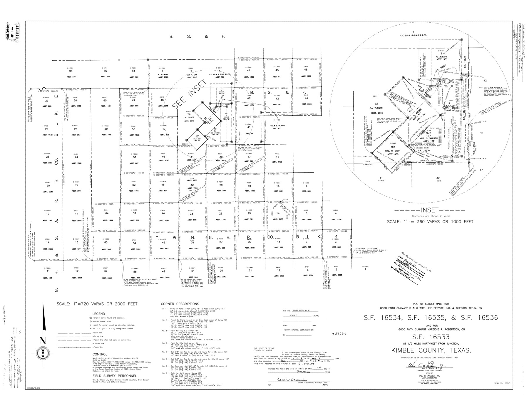
Kimble County Rolled Sketch 41
Plat of survey made for Good Faith Claimant B & G Wire Line Service, Inc. & Gregory Tatum, on SF-16534, SF-16535, & SF-16536 and for Good Faith Claimant Margene R. Robertson, on SF-16533
- 
                          Map/Doc
9340
 - 
                            Collection
General Map Collection
 - 
                            Object Dates
1994 (Creation Date)
1994/12/2 (File Date)
 - 
                            People and Organizations
Wm. C. Wilson, Jr. (Surveyor/Engineer)
Brent Burrow (Chainman/Field Personnel)
Gerald McMahan (Chainman/Field Personnel)
Brent Sawyer (Chainman/Field Personnel)
Gerald R. Price (Chainman/Field Personnel)
Clifford D. Gibson (Chainman/Field Personnel)
 - 
                            Counties
Kimble
 - 
                            Subjects
Surveying Rolled Sketch
 - 
                            Height x Width
38.0 x 48.9 inches
96.5 x 124.2 cm
 - 
                            Medium
mylar, print
 - 
                            Scale
1" = 720 varas
 - 
                            Comments
See Kimble County Sketch File 41 (29010) for report.
 
Related maps
            Kimble County Sketch File 41


                                            Print $10.00                    
                                             -                         Digital $50.00                                    
                Kimble County Sketch File 41
1994
Size 11.2 x 8.7 inches
                                Map/Doc 29010
            Part of: General Map Collection
            Controlled Mosaic by Jack Amman Photogrammetric Engineers, Inc - Sheet 6


                                            Print $20.00                    
                                             -                         Digital $50.00                                    
                Controlled Mosaic by Jack Amman Photogrammetric Engineers, Inc - Sheet 6
1954
Size 20.0 x 24.0 inches
                                Map/Doc 83450
            
            Denton County Rolled Sketch 7


                                            Print $20.00                    
                                             -                         Digital $50.00                                    
                Denton County Rolled Sketch 7
2007
Size 24.5 x 19.3 inches
                                Map/Doc 87941
            
            Roberts County Working Sketch 44


                                            Print $20.00                    
                                             -                         Digital $50.00                                    
                Roberts County Working Sketch 44
1991
Size 26.8 x 42.6 inches
                                Map/Doc 63570
            
            Montgomery County Sketch File 41


                                            Print $8.00                    
                                             -                         Digital $50.00                                    
                Montgomery County Sketch File 41
2004
Size 14.0 x 8.5 inches
                                Map/Doc 82447
            
            Maps & Lists Showing Prison Lands (Oil & Gas) Leased as of June 1955


                                                                    Digital $50.00                                    
                Maps & Lists Showing Prison Lands (Oil & Gas) Leased as of June 1955
Size 11.2 x 8.9 inches
                                Map/Doc 62875
            
            Map of Bexar County


                                            Print $20.00                    
                                             -                         Digital $50.00                                    
                Map of Bexar County
1878
Size 24.5 x 27.6 inches
                                Map/Doc 3298
            
            Brewster County Rolled Sketch 133


                                            Print $20.00                    
                                             -                         Digital $50.00                                    
                Brewster County Rolled Sketch 133
1979
Size 30.8 x 36.8 inches
                                Map/Doc 8524
            
            Duval County Boundary File 3c


                                            Print $12.00                    
                                             -                         Digital $50.00                                    
                Duval County Boundary File 3c
Size 11.7 x 8.4 inches
                                Map/Doc 52732
            
            Map of Presidio County, Texas


                                            Print $40.00                    
                                             -                         Digital $50.00                                    
                Map of Presidio County, Texas
Size 42.6 x 86.0 inches
                                Map/Doc 76071
            
            Walker County Working Sketch 6


                                            Print $20.00                    
                                             -                         Digital $50.00                                    
                Walker County Working Sketch 6
1935
Size 30.8 x 40.6 inches
                                Map/Doc 72286
            
            Map of Liberty County Texas


                                            Print $20.00                    
                                             -                         Digital $50.00                                    
                Map of Liberty County Texas
1895
Size 25.1 x 26.6 inches
                                Map/Doc 3812
            You may also like
            Right of Way & Track Map, St. Louis, Brownsville & Mexico Ry. operated by St. Louis, Brownsville & Mexico Ry. Co.


                                            Print $40.00                    
                                             -                         Digital $50.00                                    
                Right of Way & Track Map, St. Louis, Brownsville & Mexico Ry. operated by St. Louis, Brownsville & Mexico Ry. Co.
1919
Size 25.7 x 57.1 inches
                                Map/Doc 64625
            
            Hudspeth County Sketch File 29


                                            Print $20.00                    
                                             -                         Digital $50.00                                    
                Hudspeth County Sketch File 29
1918
Size 22.3 x 21.4 inches
                                Map/Doc 11804
            
            Bandera County


                                            Print $40.00                    
                                             -                         Digital $50.00                                    
                Bandera County
1947
Size 34.2 x 55.3 inches
                                Map/Doc 95424
            
            Nueces County Rolled Sketch 110


                                            Print $20.00                    
                                             -                         Digital $50.00                                    
                Nueces County Rolled Sketch 110
1990
Size 24.1 x 37.5 inches
                                Map/Doc 7117
            
            Map of Kerr County


                                            Print $20.00                    
                                             -                         Digital $50.00                                    
                Map of Kerr County
1878
Size 20.5 x 25.7 inches
                                Map/Doc 3762
            
            Flight Mission No. CRC-3R, Frame 202, Chambers County


                                            Print $20.00                    
                                             -                         Digital $50.00                                    
                Flight Mission No. CRC-3R, Frame 202, Chambers County
1956
Size 18.7 x 22.4 inches
                                Map/Doc 84857
            
            Brazoria County State Real Property Sketch 1


                                            Print $20.00                    
                                             -                         Digital $50.00                                    
                Brazoria County State Real Property Sketch 1
1997
Size 24.4 x 34.8 inches
                                Map/Doc 80127
            
            Flight Mission No. CLL-1N, Frame 106, Willacy County


                                            Print $20.00                    
                                             -                         Digital $50.00                                    
                Flight Mission No. CLL-1N, Frame 106, Willacy County
1954
Size 18.4 x 22.0 inches
                                Map/Doc 87040
            
            Titus County Working Sketch 7


                                            Print $20.00                    
                                             -                         Digital $50.00                                    
                Titus County Working Sketch 7
1970
Size 31.5 x 28.7 inches
                                Map/Doc 69368
            
            Calhoun County


                                            Print $20.00                    
                                             -                         Digital $50.00                                    
                Calhoun County
1883
Size 22.9 x 19.1 inches
                                Map/Doc 66741