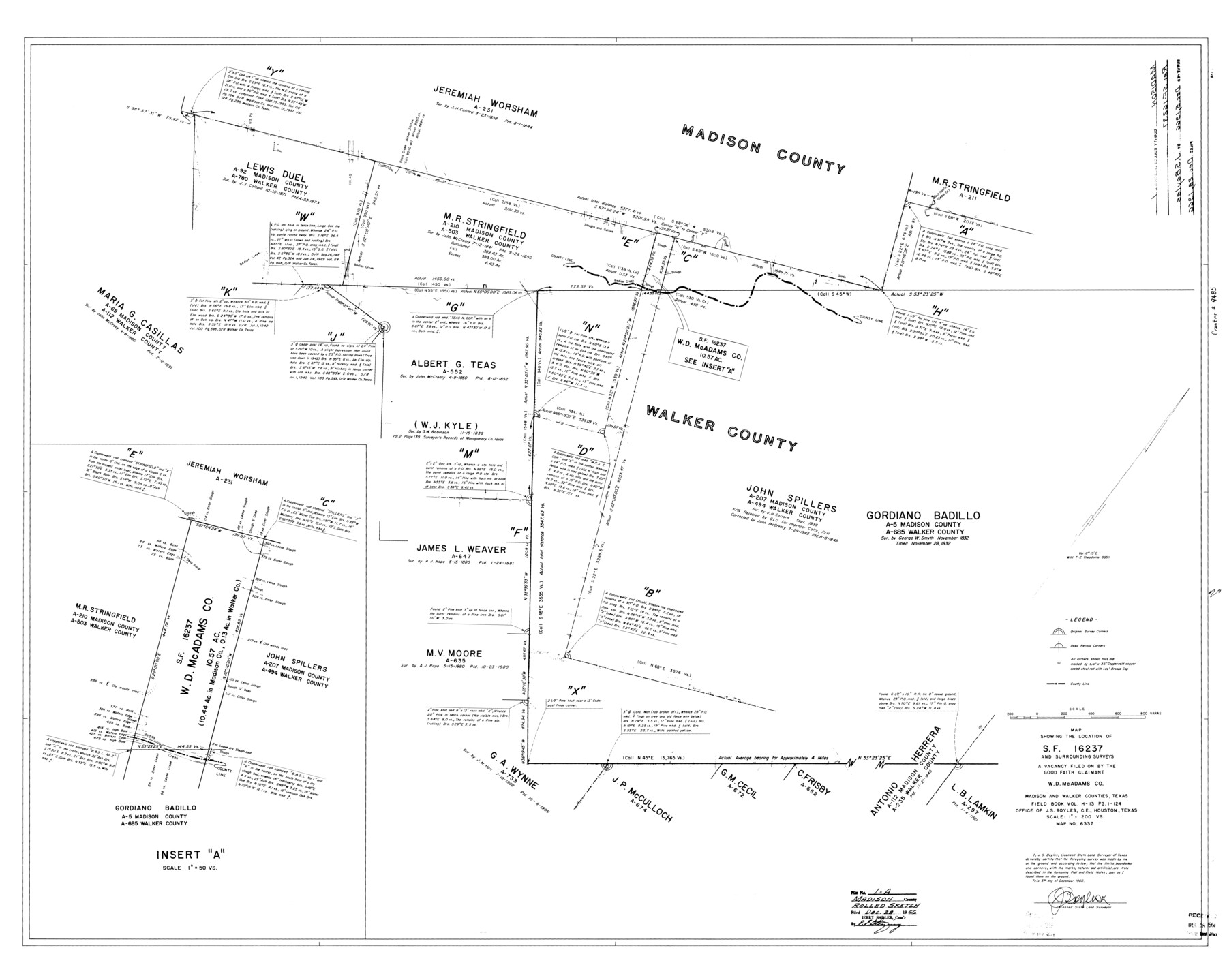
Madison County Rolled Sketch 1
Map showing the location of SF-16237 and surrounding surveys, a vacancy filed on by the Good Faith Claimant W.D. McAdams Co., Madison and Walker Counties, Texas
-
Map/Doc
9485
-
Collection
General Map Collection
-
Object Dates
1966/12/5 (Creation Date)
1966/12/28 (File Date)
-
People and Organizations
J.S. Boyles (Surveyor/Engineer)
-
Counties
Madison Walker
-
Subjects
Surveying Rolled Sketch
-
Height x Width
36.7 x 46.0 inches
93.2 x 116.8 cm
-
Scale
1" = 200 varas
Part of: General Map Collection
Knox County Sketch File 26

Print $40.00
- Digital $50.00
Knox County Sketch File 26
1957
Size 17.3 x 14.4 inches
Map/Doc 29262
[Surveys along Verde and Bandera Creeks]
![289, [Surveys along Verde and Bandera Creeks], General Map Collection](https://historictexasmaps.com/wmedia_w700/maps/289.tif.jpg)
Print $2.00
- Digital $50.00
[Surveys along Verde and Bandera Creeks]
1846
Size 10.0 x 8.0 inches
Map/Doc 289
Anderson County Working Sketch 22

Print $20.00
- Digital $50.00
Anderson County Working Sketch 22
1954
Size 22.7 x 24.2 inches
Map/Doc 67022
Flight Mission No. BRE-1P, Frame 55, Nueces County

Print $20.00
- Digital $50.00
Flight Mission No. BRE-1P, Frame 55, Nueces County
1956
Size 18.3 x 22.2 inches
Map/Doc 86644
Culberson County Rolled Sketch 67

Print $20.00
- Digital $50.00
Culberson County Rolled Sketch 67
1969
Size 18.1 x 23.1 inches
Map/Doc 5785
Harris County Sketch File 88

Print $171.00
- Digital $50.00
Harris County Sketch File 88
1914
Size 13.8 x 12.1 inches
Map/Doc 25555
Tarrant County Working Sketch 16

Print $20.00
- Digital $50.00
Tarrant County Working Sketch 16
1991
Size 14.5 x 23.9 inches
Map/Doc 62433
Panola County

Print $20.00
- Digital $50.00
Panola County
1947
Size 41.7 x 41.3 inches
Map/Doc 95607
Webb County Rolled Sketch 21

Print $20.00
- Digital $50.00
Webb County Rolled Sketch 21
1930
Size 32.9 x 23.0 inches
Map/Doc 8183
Schleicher County Sketch File 24a

Print $20.00
- Digital $50.00
Schleicher County Sketch File 24a
Size 16.1 x 16.4 inches
Map/Doc 12303
Comanche County Sketch File 8

Print $4.00
- Digital $50.00
Comanche County Sketch File 8
1853
Size 13.1 x 8.2 inches
Map/Doc 19066
Flight Mission No. DQN-2K, Frame 156, Calhoun County

Print $20.00
- Digital $50.00
Flight Mission No. DQN-2K, Frame 156, Calhoun County
1953
Size 18.5 x 22.3 inches
Map/Doc 84318
You may also like
Cooke County Working Sketch 17

Print $20.00
- Digital $50.00
Cooke County Working Sketch 17
1950
Size 24.7 x 17.8 inches
Map/Doc 68254
Jackson County Sketch File 13

Print $40.00
- Digital $50.00
Jackson County Sketch File 13
Size 29.0 x 18.6 inches
Map/Doc 11839
Map of the country in the vicinity of San Antonio de Bexar reduced in part from the county map of Bexar with additions by J. Edmd. Blake, 1st Lieut Topl. Engs.

Print $20.00
- Digital $50.00
Map of the country in the vicinity of San Antonio de Bexar reduced in part from the county map of Bexar with additions by J. Edmd. Blake, 1st Lieut Topl. Engs.
1845
Size 18.1 x 25.7 inches
Map/Doc 72722
Henderson County Working Sketch 40

Print $20.00
- Digital $50.00
Henderson County Working Sketch 40
1982
Size 23.2 x 19.0 inches
Map/Doc 66173
Nacogdoches Co.

Print $20.00
- Digital $50.00
Nacogdoches Co.
1905
Size 47.6 x 40.5 inches
Map/Doc 66948
Flight Mission No. DAG-17K, Frame 70, Matagorda County

Print $20.00
- Digital $50.00
Flight Mission No. DAG-17K, Frame 70, Matagorda County
1952
Size 18.6 x 22.4 inches
Map/Doc 86329
Liberty County Rolled Sketch N

Print $20.00
- Digital $50.00
Liberty County Rolled Sketch N
Size 44.7 x 38.5 inches
Map/Doc 10180
Morris County Working Sketch 4

Print $20.00
- Digital $50.00
Morris County Working Sketch 4
1959
Size 35.2 x 23.8 inches
Map/Doc 71203
Edwards County Working Sketch 38

Print $20.00
- Digital $50.00
Edwards County Working Sketch 38
1948
Size 28.4 x 43.9 inches
Map/Doc 68914
Colton's New Map of the State of Texas, the Indian Territory and adjoining portions of New Mexico, Louisiana and Arkansas

Print $2.00
- Digital $50.00
Colton's New Map of the State of Texas, the Indian Territory and adjoining portions of New Mexico, Louisiana and Arkansas
1882
Size 8.5 x 5.0 inches
Map/Doc 93921
Jasper County Working Sketch 13

Print $20.00
- Digital $50.00
Jasper County Working Sketch 13
1920
Size 24.3 x 17.1 inches
Map/Doc 66475
Hardin County Sketch File 15

Print $6.00
- Digital $50.00
Hardin County Sketch File 15
Size 9.0 x 4.9 inches
Map/Doc 25122