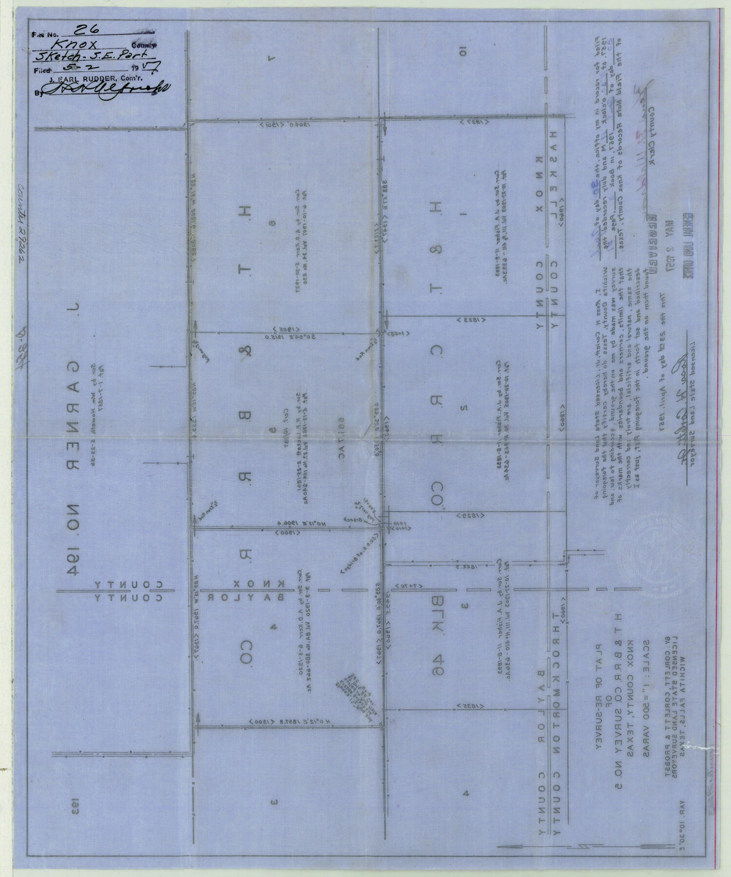
Knox County Sketch File 26
Plat of re-survey of H. T. & B. RR. Co. survey no. 5
-
Map/Doc
29262
-
Collection
General Map Collection
-
Object Dates
4/23/1957 (Creation Date)
5/2/1957 (File Date)
-
People and Organizations
Ross H. Corlett, Jr. (Surveyor/Engineer)
William Howeth (Surveyor/Engineer)
-
Counties
Knox Baylor
-
Subjects
Surveying Sketch File
-
Height x Width
17.3 x 14.4 inches
43.9 x 36.6 cm
-
Medium
paper, manuscript
-
Scale
1" = 500 varas
Part of: General Map Collection
Concho County Working Sketch 21

Print $20.00
- Digital $50.00
Concho County Working Sketch 21
1957
Size 36.4 x 36.0 inches
Map/Doc 68203
McLennan County Sketch File 29

Print $4.00
- Digital $50.00
McLennan County Sketch File 29
Size 4.5 x 8.2 inches
Map/Doc 31302
Trinity River, Malloy Bridge Sheet

Print $20.00
- Digital $50.00
Trinity River, Malloy Bridge Sheet
1922
Size 41.7 x 40.2 inches
Map/Doc 65189
Carte Generale des Treize Etats-Unis de l'Amerique Septentrionale

Print $20.00
- Digital $50.00
Carte Generale des Treize Etats-Unis de l'Amerique Septentrionale
1783
Size 22.9 x 27.0 inches
Map/Doc 93678
Midland County Rolled Sketch REE

Print $20.00
- Digital $50.00
Midland County Rolled Sketch REE
1937
Size 27.1 x 24.3 inches
Map/Doc 6771
Coast Chart No. 203 - Coast of Texas from Sabine Pass Westward to High Island

Print $20.00
- Digital $50.00
Coast Chart No. 203 - Coast of Texas from Sabine Pass Westward to High Island
1901
Size 40.4 x 34.3 inches
Map/Doc 69843
Stonewall County Sketch File 14

Print $20.00
- Digital $50.00
Stonewall County Sketch File 14
1901
Size 21.5 x 18.3 inches
Map/Doc 12366
Montague County Working Sketch 35

Print $20.00
- Digital $50.00
Montague County Working Sketch 35
1980
Size 24.8 x 31.9 inches
Map/Doc 71101
Flight Mission No. DQO-8K, Frame 47, Galveston County

Print $20.00
- Digital $50.00
Flight Mission No. DQO-8K, Frame 47, Galveston County
1952
Size 18.7 x 22.2 inches
Map/Doc 85154
Brazoria County Sketch File 12

Print $8.00
- Digital $50.00
Brazoria County Sketch File 12
1886
Size 12.8 x 8.2 inches
Map/Doc 14967
Young County Sketch File 7

Print $6.00
- Digital $50.00
Young County Sketch File 7
1856
Size 8.4 x 9.2 inches
Map/Doc 40859
Harris County Sketch File 62

Print $14.00
- Digital $50.00
Harris County Sketch File 62
1930
Size 11.4 x 8.7 inches
Map/Doc 25486
You may also like
[Cotton Belt, St. Louis Southwestern Railway of Texas, Alignment through Smith County]
![64383, [Cotton Belt, St. Louis Southwestern Railway of Texas, Alignment through Smith County], General Map Collection](https://historictexasmaps.com/wmedia_w700/maps/64383.tif.jpg)
Print $20.00
- Digital $50.00
[Cotton Belt, St. Louis Southwestern Railway of Texas, Alignment through Smith County]
1903
Size 21.5 x 29.4 inches
Map/Doc 64383
Copy of Surveyor's Field Book, Morris Browning - In Blocks 7, 5 & 4, I&GNRRCo., Hutchinson and Carson Counties, Texas

Print $2.00
- Digital $50.00
Copy of Surveyor's Field Book, Morris Browning - In Blocks 7, 5 & 4, I&GNRRCo., Hutchinson and Carson Counties, Texas
1888
Size 6.9 x 8.8 inches
Map/Doc 62262
University of Texas System University Lands

Print $20.00
- Digital $50.00
University of Texas System University Lands
Size 17.9 x 23.3 inches
Map/Doc 93244
[Capitol League Sketch in Bailey & Lamb Counties, Texas]
![1764, [Capitol League Sketch in Bailey & Lamb Counties, Texas], General Map Collection](https://historictexasmaps.com/wmedia_w700/maps/1764.tif.jpg)
Print $20.00
- Digital $50.00
[Capitol League Sketch in Bailey & Lamb Counties, Texas]
1910
Size 19.7 x 28.0 inches
Map/Doc 1764
Flight Mission No. DQO-1K, Frame 19, Galveston County

Print $20.00
- Digital $50.00
Flight Mission No. DQO-1K, Frame 19, Galveston County
1952
Size 18.9 x 22.6 inches
Map/Doc 84978
[Lgs. 209-212, 182, 183, 195-200 with notes]
![90159, [Lgs. 209-212, 182, 183, 195-200 with notes], Twichell Survey Records](https://historictexasmaps.com/wmedia_w700/maps/90159-1.tif.jpg)
Print $20.00
- Digital $50.00
[Lgs. 209-212, 182, 183, 195-200 with notes]
Size 18.7 x 15.6 inches
Map/Doc 90159
Anderson County Working Sketch 13

Print $20.00
- Digital $50.00
Anderson County Working Sketch 13
1930
Size 34.0 x 21.9 inches
Map/Doc 67013
[Gunter & Munson, Maddox Bros. & Anderson Blocks F and A and State University Lands Blocks 15-17 and 50]
![91847, [Gunter & Munson, Maddox Bros. & Anderson Blocks F and A and State University Lands Blocks 15-17 and 50], Twichell Survey Records](https://historictexasmaps.com/wmedia_w700/maps/91847-1.tif.jpg)
Print $20.00
- Digital $50.00
[Gunter & Munson, Maddox Bros. & Anderson Blocks F and A and State University Lands Blocks 15-17 and 50]
1884
Size 12.2 x 16.2 inches
Map/Doc 91847
Flight Mission No. DAH-9M, Frame 161, Orange County

Print $20.00
- Digital $50.00
Flight Mission No. DAH-9M, Frame 161, Orange County
1953
Size 18.6 x 22.4 inches
Map/Doc 86860
Roberts County Sketch File 7

Print $16.00
- Digital $50.00
Roberts County Sketch File 7
1992
Size 14.3 x 8.8 inches
Map/Doc 35316
San Saba County Sketch File 18

Print $12.00
- Digital $50.00
San Saba County Sketch File 18
1919
Size 11.4 x 8.8 inches
Map/Doc 36460
La Salle County Sketch File 21

Print $6.00
- Digital $50.00
La Salle County Sketch File 21
1883
Size 11.0 x 10.5 inches
Map/Doc 29526