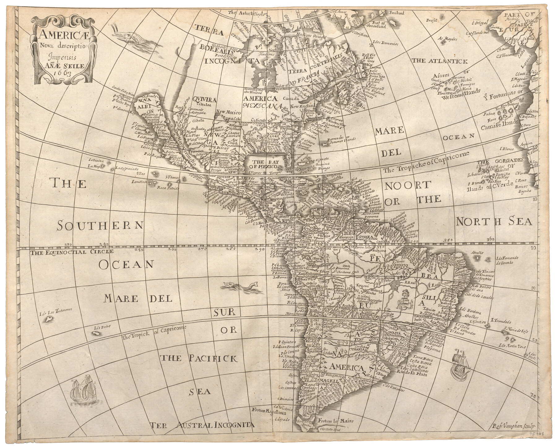
Americae Nova Descriptio
-
Map/Doc
95708
-
Collection
General Map Collection
-
Object Dates
1663 (Creation Date)
-
People and Organizations
Robert Vaughan (Printer)
Anae Seile (Cartographer)
-
Subjects
North America South America
-
Height x Width
14.5 x 18.0 inches
36.8 x 45.7 cm
-
Medium
paper, etching/engraving/lithograph
-
Comments
From the publication "Cosmography in Four Books Containing the Chorography and History of the Whole World"
Part of: General Map Collection
Right of Way and Track Map, the Missouri, Kansas and Texas Ry. of Texas - Henrietta Division

Print $20.00
- Digital $50.00
Right of Way and Track Map, the Missouri, Kansas and Texas Ry. of Texas - Henrietta Division
1918
Size 11.7 x 26.8 inches
Map/Doc 64756
Map of University Land part of Fifty League Grant Act of 1839

Print $20.00
- Digital $50.00
Map of University Land part of Fifty League Grant Act of 1839
1905
Size 40.7 x 28.7 inches
Map/Doc 2430
Val Verde County Sketch File AA3

Print $20.00
- Digital $50.00
Val Verde County Sketch File AA3
1924
Size 19.5 x 20.6 inches
Map/Doc 12540
Live Oak County Rolled Sketch 8

Print $20.00
- Digital $50.00
Live Oak County Rolled Sketch 8
1969
Size 43.5 x 32.8 inches
Map/Doc 9455
Jones County Sketch File 19

Print $56.00
- Digital $50.00
Jones County Sketch File 19
1875
Size 11.1 x 8.6 inches
Map/Doc 28516
Flight Mission No. BRA-9M, Frame 70, Jefferson County

Print $20.00
- Digital $50.00
Flight Mission No. BRA-9M, Frame 70, Jefferson County
1953
Size 18.6 x 22.5 inches
Map/Doc 85653
University Land Field Notes for Blocks 46 and 48 in Culberson County

University Land Field Notes for Blocks 46 and 48 in Culberson County
Map/Doc 81721
Red River County Sketch File 8b

Print $6.00
- Digital $50.00
Red River County Sketch File 8b
1860
Size 8.2 x 3.7 inches
Map/Doc 35114
Index for Texas Railroad ROW & track maps available on microfilm at THD & Archives and Records

Print $2.00
- Digital $50.00
Index for Texas Railroad ROW & track maps available on microfilm at THD & Archives and Records
1977
Size 11.1 x 8.6 inches
Map/Doc 60763
[Sketch for Mineral Application 13436 - Cut-off Bayou]
![65676, [Sketch for Mineral Application 13436 - Cut-off Bayou], General Map Collection](https://historictexasmaps.com/wmedia_w700/maps/65676-1.tif.jpg)
Print $20.00
- Digital $50.00
[Sketch for Mineral Application 13436 - Cut-off Bayou]
1928
Size 44.1 x 21.6 inches
Map/Doc 65676
Pecos County Boundary File 69

Print $22.00
- Digital $50.00
Pecos County Boundary File 69
Size 7.8 x 3.4 inches
Map/Doc 57890
Hunt County Working Sketch 8

Print $20.00
- Digital $50.00
Hunt County Working Sketch 8
1958
Size 24.5 x 24.4 inches
Map/Doc 66355
You may also like
Fannin County Working Sketch 7

Print $20.00
- Digital $50.00
Fannin County Working Sketch 7
1952
Size 25.4 x 28.5 inches
Map/Doc 69161
[Sketch showing surveys in Blocks 70, 71 and 72 surrounding the town of Toyah]
![91750, [Sketch showing surveys in Blocks 70, 71 and 72 surrounding the town of Toyah], Twichell Survey Records](https://historictexasmaps.com/wmedia_w700/maps/91750-1.tif.jpg)
Print $20.00
- Digital $50.00
[Sketch showing surveys in Blocks 70, 71 and 72 surrounding the town of Toyah]
Size 44.9 x 26.1 inches
Map/Doc 91750
Duval County Rolled Sketch E

Print $20.00
- Digital $50.00
Duval County Rolled Sketch E
1935
Size 36.4 x 37.7 inches
Map/Doc 8808
Potter County Sketch File 16

Print $38.00
- Digital $50.00
Potter County Sketch File 16
Size 13.0 x 13.9 inches
Map/Doc 34401
[Map of the Fort Worth & Denver City Railway, Hartley County, Texas]
![64389, [Map of the Fort Worth & Denver City Railway, Hartley County, Texas], General Map Collection](https://historictexasmaps.com/wmedia_w700/maps/64389.tif.jpg)
Print $40.00
- Digital $50.00
[Map of the Fort Worth & Denver City Railway, Hartley County, Texas]
1887
Size 22.0 x 120.7 inches
Map/Doc 64389
Taylor County Working Sketch 17

Print $20.00
- Digital $50.00
Taylor County Working Sketch 17
1982
Size 42.7 x 37.0 inches
Map/Doc 69627
Corpus Christi Harbor

Print $40.00
- Digital $50.00
Corpus Christi Harbor
1973
Size 37.8 x 51.9 inches
Map/Doc 73478
Victoria County Sketch File 5a

Print $2.00
- Digital $50.00
Victoria County Sketch File 5a
Size 8.2 x 12.9 inches
Map/Doc 39522
Rusk County Sketch File 25

Print $20.00
Rusk County Sketch File 25
1932
Size 20.5 x 20.3 inches
Map/Doc 12272
Motley County Sketch File 34 (S)

Print $20.00
- Digital $50.00
Motley County Sketch File 34 (S)
1951
Size 26.5 x 13.6 inches
Map/Doc 42149
Harris County Historic Topographic 1

Print $20.00
- Digital $50.00
Harris County Historic Topographic 1
1916
Size 29.3 x 22.7 inches
Map/Doc 65811
Val Verde County Working Sketch 64

Print $20.00
- Digital $50.00
Val Verde County Working Sketch 64
1959
Size 19.0 x 43.0 inches
Map/Doc 72199