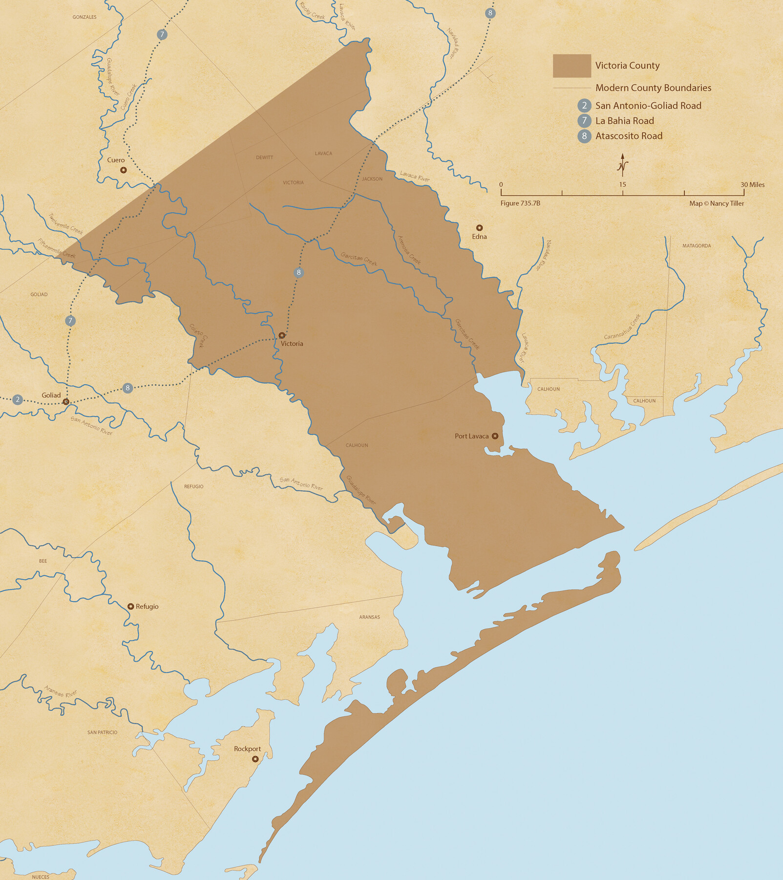
The Republic County of Victoria. Spring 1842
Figure No. 735.7 from 'A Boundary Atlas of Texas, 1821-1845' by Jim Tiller
-
Map/Doc
96300
-
Collection
Nancy and Jim Tiller Digital Collection
-
Object Dates
2020/1/1 (Creation Date)
-
People and Organizations
Jim Tiller (Author)
Nancy Tiller (Cartographer)
Gang Gong (GIS Professional)
-
Counties
Victoria
-
Subjects
Atlas County Republic of Texas Texas Boundaries
-
Height x Width
24.3 x 21.7 inches
61.7 x 55.1 cm
-
Medium
digital image
-
Comments
To purchase a digital PDF copy of "A Boundary Atlas of Texas, 1821-1845" see 96437.
Part of: Nancy and Jim Tiller Digital Collection
The Chief Justice County of Nacogdoches. April 25, 1837

Print $20.00
The Chief Justice County of Nacogdoches. April 25, 1837
2020
Size 17.6 x 21.7 inches
Map/Doc 96063
The Republic County of Jefferson. January 20, 1841

Print $20.00
The Republic County of Jefferson. January 20, 1841
2020
Size 22.6 x 21.7 inches
Map/Doc 96198
The Republic County of Colorado. January 19, 1841

Print $20.00
The Republic County of Colorado. January 19, 1841
2020
Size 18.4 x 21.7 inches
Map/Doc 96124
The Republic County of Gonzales. February 2, 1842

Print $20.00
The Republic County of Gonzales. February 2, 1842
2020
Size 14.7 x 21.7 inches
Map/Doc 96158
The Republic County of Washington. February 1, 1844

Print $20.00
The Republic County of Washington. February 1, 1844
2020
Size 11.8 x 21.7 inches
Map/Doc 96309
The Republic County of Matagorda. Refined, January 25, 1841

Print $20.00
The Republic County of Matagorda. Refined, January 25, 1841
2020
Size 19.3 x 21.8 inches
Map/Doc 96221
The Republic County of Gonzales. Spring 1842

Print $20.00
The Republic County of Gonzales. Spring 1842
2020
Size 14.7 x 21.7 inches
Map/Doc 96159
The Republic County of Bexar. December 2, 1841

Print $20.00
The Republic County of Bexar. December 2, 1841
2020
Size 14.8 x 21.7 inches
Map/Doc 96098
From Citizens of Gonzales County for the Creation of a New Judicial County (Unnamed), December 14, 1841

Print $20.00
From Citizens of Gonzales County for the Creation of a New Judicial County (Unnamed), December 14, 1841
2020
Size 24.1 x 21.7 inches
Map/Doc 96410
The Republic County of Matagorda. Proposed, Late Fall 1837-January 1, 1838

Print $20.00
The Republic County of Matagorda. Proposed, Late Fall 1837-January 1, 1838
2020
Size 21.0 x 21.7 inches
Map/Doc 96215
de Leon Empresario Colony. Absorbed by DeWitt Colony. April 15, 1825

Print $20.00
de Leon Empresario Colony. Absorbed by DeWitt Colony. April 15, 1825
2020
Size 18.5 x 21.7 inches
Map/Doc 95989
The Republic County of Goliad. Proposed, Late Fall 1837-December 31, 1838

Print $20.00
The Republic County of Goliad. Proposed, Late Fall 1837-December 31, 1838
2020
Size 15.1 x 21.7 inches
Map/Doc 96148
You may also like
Flight Mission No. DAH-9M, Frame 83, Orange County

Print $20.00
- Digital $50.00
Flight Mission No. DAH-9M, Frame 83, Orange County
1953
Size 18.5 x 22.3 inches
Map/Doc 86847
Duval County Working Sketch 34

Print $20.00
- Digital $50.00
Duval County Working Sketch 34
1953
Size 35.8 x 25.5 inches
Map/Doc 68758
Terrell County Rolled Sketch 29

Print $20.00
- Digital $50.00
Terrell County Rolled Sketch 29
1929
Size 27.5 x 41.9 inches
Map/Doc 7936
Duval County Working Sketch 17

Print $20.00
- Digital $50.00
Duval County Working Sketch 17
1939
Size 14.6 x 25.1 inches
Map/Doc 68730
Mason County Rolled Sketch 2

Print $20.00
- Digital $50.00
Mason County Rolled Sketch 2
1952
Size 32.9 x 26.7 inches
Map/Doc 6675
[League 239, Portion of Block B5]
![91443, [League 239, Portion of Block B5], Twichell Survey Records](https://historictexasmaps.com/wmedia_w700/maps/91443-1.tif.jpg)
Print $20.00
- Digital $50.00
[League 239, Portion of Block B5]
Size 18.4 x 11.7 inches
Map/Doc 91443
North Tech Addition, Section 18, Block A

Print $20.00
- Digital $50.00
North Tech Addition, Section 18, Block A
1952
Size 17.9 x 23.0 inches
Map/Doc 92756

Dallam County

Print $40.00
- Digital $50.00
Dallam County
1926
Size 39.9 x 48.6 inches
Map/Doc 95474
The Republic County of Bexar. January 29, 1842

Print $20.00
The Republic County of Bexar. January 29, 1842
2020
Size 14.7 x 21.7 inches
Map/Doc 96099
Harbor of Brazos Santiago, Texas

Print $20.00
- Digital $50.00
Harbor of Brazos Santiago, Texas
1887
Size 27.1 x 18.3 inches
Map/Doc 72994
Louisiana and Texas Intracoastal Waterway

Print $20.00
- Digital $50.00
Louisiana and Texas Intracoastal Waterway
1929
Size 13.6 x 19.8 inches
Map/Doc 83345