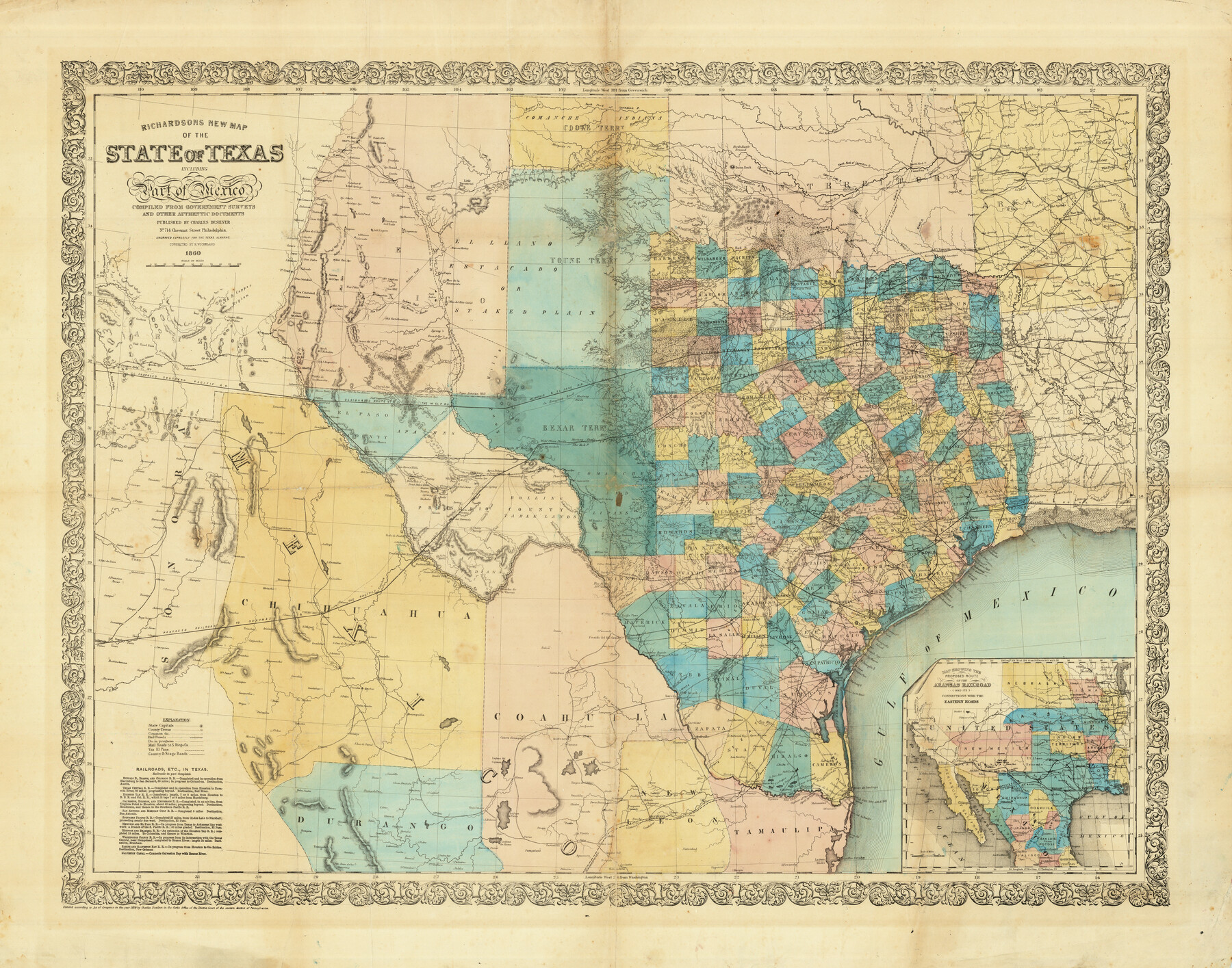
Richardson's New Map of the State of Texas Including Part of Mexico Compiled From Government Surveys and Other Authentic Documents
[Inset:] Map Showing the Proposed Route of the Aransas Railroad and its Connections With the Eastern Roads
-
Map/Doc
96788
-
Collection
Holcomb Map Collection
-
Object Dates
1860 (Creation Date)
-
People and Organizations
Charles Desilver (Publisher)
H. Wickeland (Draftsman)
-
Subjects
State of Texas
-
Height x Width
28.5 x 36.3 inches
72.4 x 92.2 cm
-
Medium
digital image
-
Comments
Courtesy of Frank and Carol Holcomb.
Engraved expressly for the Texas Almanac. Corrected by H. Wickeland.
Part of: Holcomb Map Collection
Amerique Septentrionale divisée en ses principales parties

Print $20.00
- Digital $50.00
Amerique Septentrionale divisée en ses principales parties
1792
Size 21.3 x 25.9 inches
Map/Doc 93916
Bird's Eye View of the City of Houston, Texas

Print $20.00
- Digital $50.00
Bird's Eye View of the City of Houston, Texas
1873
Size 25.2 x 31.5 inches
Map/Doc 93908
The History of the Republic of Texas, from the discovery of the country to the present time; and the cause of her separation from the Republic of Mexico.

Print $1080.00
- Digital $50.00
The History of the Republic of Texas, from the discovery of the country to the present time; and the cause of her separation from the Republic of Mexico.
1842
Size 9.3 x 6.1 inches
Map/Doc 93866
Mapa de los Estados Unidos de Méjico, Segun lo organizado y definido por las varias actas del Congreso de dicha Republica: y construido por las mejores autoridades

Print $20.00
- Digital $50.00
Mapa de los Estados Unidos de Méjico, Segun lo organizado y definido por las varias actas del Congreso de dicha Republica: y construido por las mejores autoridades
1847
Size 31.3 x 42.3 inches
Map/Doc 93878
A Map of the United States including Louisiana

Print $20.00
- Digital $50.00
A Map of the United States including Louisiana
1817
Size 14.9 x 18.2 inches
Map/Doc 95964
J. De Cordova's Map of the State of Texas Compiled from the records of the General Land Office of the State

Print $20.00
- Digital $50.00
J. De Cordova's Map of the State of Texas Compiled from the records of the General Land Office of the State
1849
Size 33.7 x 36.1 inches
Map/Doc 94026
Carte du Mexique et de la Floride des Terres Angloises et des Isles Antilles du cours et des environs de la Riviere de Mississipi

Print $20.00
- Digital $50.00
Carte du Mexique et de la Floride des Terres Angloises et des Isles Antilles du cours et des environs de la Riviere de Mississipi
1703
Size 19.0 x 25.8 inches
Map/Doc 96519
[Map of the Texas & Pacific Railway and connections]
![95414, [Map of the Texas & Pacific Railway and connections], Holcomb Digital Map Collection](https://historictexasmaps.com/wmedia_w700/maps/95414.tif.jpg)
Print $20.00
- Digital $50.00
[Map of the Texas & Pacific Railway and connections]
1902
Size 18.0 x 37.0 inches
Map/Doc 95414
Map of Europe designed to accompany Smith's Geography for Schools

Print $20.00
- Digital $50.00
Map of Europe designed to accompany Smith's Geography for Schools
1850
Size 9.8 x 12.1 inches
Map/Doc 93892
Karte des Staates, Texas

Print $20.00
- Digital $50.00
Karte des Staates, Texas
1851
Size 17.8 x 19.9 inches
Map/Doc 97191
Bowles's New Pocket Map of America divided into its Provinces, Colonies, States, Governments &c. exhibiting the British and Spanish Empires therein; together with the Territories belonging to the French, Dutch, Danes & Portuguese

Print $20.00
- Digital $50.00
Bowles's New Pocket Map of America divided into its Provinces, Colonies, States, Governments &c. exhibiting the British and Spanish Empires therein; together with the Territories belonging to the French, Dutch, Danes & Portuguese
1784
Size 21.3 x 23.1 inches
Map/Doc 93838
A New Map of Texas with the Contiguous American & Mexican States

Print $20.00
- Digital $50.00
A New Map of Texas with the Contiguous American & Mexican States
1835
Size 12.9 x 15.8 inches
Map/Doc 93853
You may also like
Map of the Survey of the 100th Meridian of Longitude west of Greenwich beginning at Red River and extending to the parallel 36 1/2 degrees north latitude

Print $40.00
- Digital $50.00
Map of the Survey of the 100th Meridian of Longitude west of Greenwich beginning at Red River and extending to the parallel 36 1/2 degrees north latitude
Size 11.4 x 111.7 inches
Map/Doc 93191
Borden County Rolled Sketch 9

Print $40.00
- Digital $50.00
Borden County Rolled Sketch 9
1951
Size 114.7 x 29.6 inches
Map/Doc 8448
Tarrant County Rolled Sketch 3

Print $20.00
- Digital $50.00
Tarrant County Rolled Sketch 3
Size 23.3 x 28.6 inches
Map/Doc 7910
[Sketch for Mineral Applications 7410, 7411, 7412, 7413, 7712 - Kleberg County]
![65623, [Sketch for Mineral Applications 7410, 7411, 7412, 7413, 7712 - Kleberg County], General Map Collection](https://historictexasmaps.com/wmedia_w700/maps/65623-1.tif.jpg)
Print $40.00
- Digital $50.00
[Sketch for Mineral Applications 7410, 7411, 7412, 7413, 7712 - Kleberg County]
1977
Size 44.6 x 92.4 inches
Map/Doc 65623
Crockett County Sketch File 46

Print $20.00
- Digital $50.00
Crockett County Sketch File 46
Size 11.1 x 8.7 inches
Map/Doc 19779
Oso Creek, Rodd Field (P-1) Sheet

Print $20.00
- Digital $50.00
Oso Creek, Rodd Field (P-1) Sheet
1942
Size 33.2 x 34.0 inches
Map/Doc 65096
Howard County Sketch File 3

Print $12.00
- Digital $50.00
Howard County Sketch File 3
1909
Size 9.0 x 8.3 inches
Map/Doc 26855
Wheeler County Sketch File 1

Print $20.00
- Digital $50.00
Wheeler County Sketch File 1
Size 17.1 x 26.8 inches
Map/Doc 12672
Baylor County Sketch File A4

Print $8.00
- Digital $50.00
Baylor County Sketch File A4
Size 14.0 x 8.7 inches
Map/Doc 14084
[Connecting line from southwest corner of S. K. & K. Blk M6 to southwest corner I. & G. N. Blk. 6]
![90411, [Connecting line from southwest corner of S. K. & K. Blk M6 to southwest corner I. & G. N. Blk. 6], Twichell Survey Records](https://historictexasmaps.com/wmedia_w700/maps/90411-1.tif.jpg)
Print $20.00
- Digital $50.00
[Connecting line from southwest corner of S. K. & K. Blk M6 to southwest corner I. & G. N. Blk. 6]
Size 26.4 x 26.9 inches
Map/Doc 90411
Coke County Working Sketch 29

Print $20.00
- Digital $50.00
Coke County Working Sketch 29
1982
Size 19.6 x 25.4 inches
Map/Doc 68066
Map of Wilbarger County

Print $40.00
- Digital $50.00
Map of Wilbarger County
1887
Size 52.2 x 47.0 inches
Map/Doc 16926