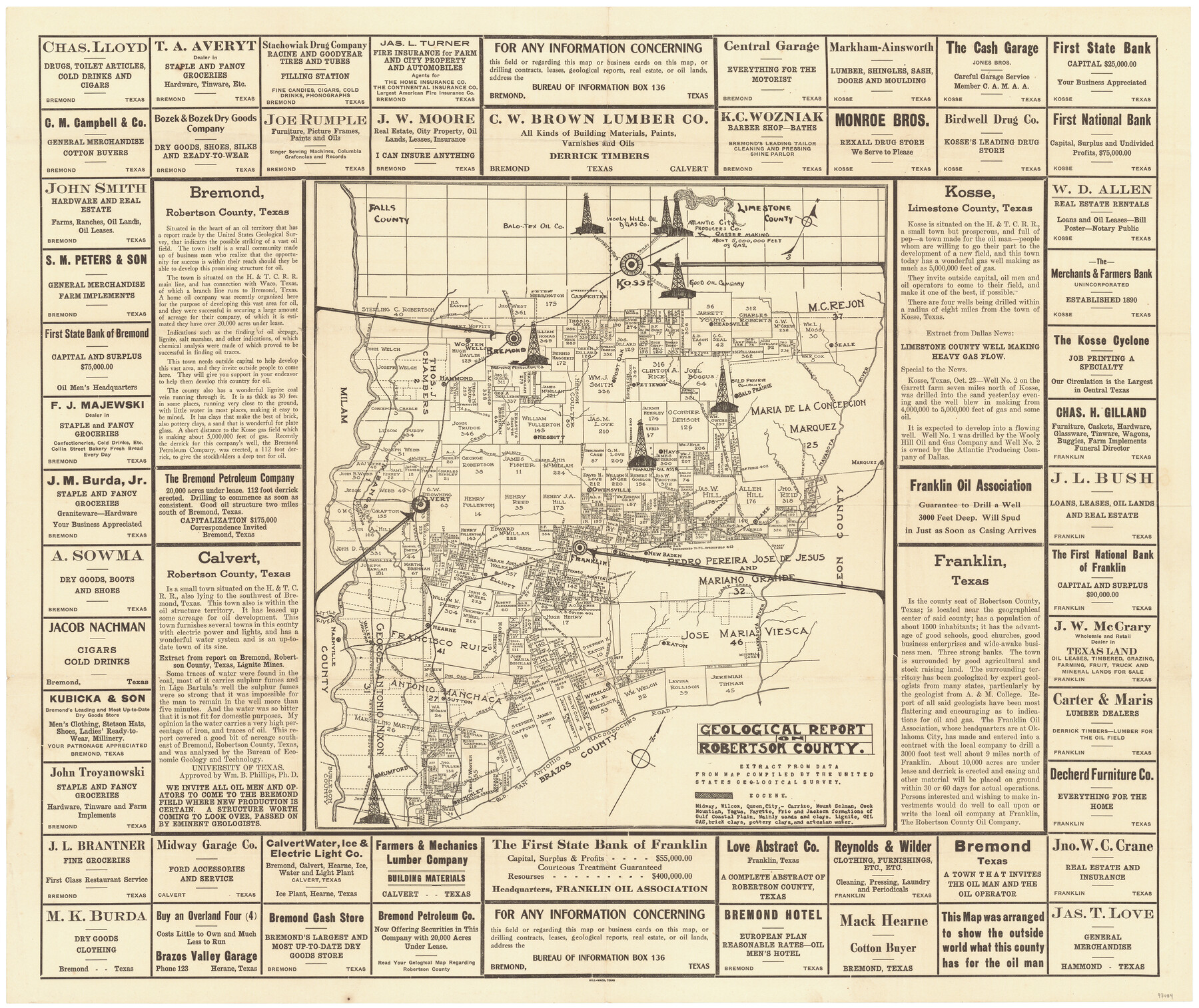
Geological Report on Robertson County
-
Map/Doc
97084
-
Collection
General Map Collection
-
Object Dates
[1918] (Creation Date)
-
Counties
Robertson
-
Subjects
Energy Surface
-
Height x Width
21.7 x 25.8 inches
55.1 x 65.5 cm
-
Medium
paper, etching/engraving/lithograph
Part of: General Map Collection
Frio County Working Sketch 22

Print $20.00
- Digital $50.00
Frio County Working Sketch 22
1990
Size 24.9 x 33.9 inches
Map/Doc 69296
Gulf of Mexico

Print $20.00
- Digital $50.00
Gulf of Mexico
1900
Size 18.3 x 28.1 inches
Map/Doc 72650
McCulloch County Rolled Sketch 5

Print $20.00
- Digital $50.00
McCulloch County Rolled Sketch 5
Size 25.7 x 20.9 inches
Map/Doc 6716
Cameron County State Real Property Sketch 2

Print $20.00
- Digital $50.00
Cameron County State Real Property Sketch 2
1996
Size 25.4 x 39.1 inches
Map/Doc 80132
Atascosa County Sketch File 41a

Print $10.00
- Digital $50.00
Atascosa County Sketch File 41a
1956
Size 9.3 x 7.4 inches
Map/Doc 13841
Flight Mission No. BRE-2P, Frame 136, Nueces County

Print $20.00
- Digital $50.00
Flight Mission No. BRE-2P, Frame 136, Nueces County
1956
Size 18.5 x 22.6 inches
Map/Doc 86809
Bee County Working Sketch 26

Print $20.00
- Digital $50.00
Bee County Working Sketch 26
1987
Size 30.9 x 36.0 inches
Map/Doc 67276
McCulloch County Sketch File 5

Print $11.00
- Digital $50.00
McCulloch County Sketch File 5
1899
Size 17.5 x 9.2 inches
Map/Doc 31177

Johnson's New Military Map of the United States Showing the Forts, Military Posts & c. with Enlarged Plans of Southern Harbors

Print $20.00
- Digital $50.00
Johnson's New Military Map of the United States Showing the Forts, Military Posts & c. with Enlarged Plans of Southern Harbors
1863
Size 17.7 x 23.3 inches
Map/Doc 93289
Winkler County Sketch File 1 and 2

Print $64.00
- Digital $50.00
Winkler County Sketch File 1 and 2
1900
Size 8.4 x 9.2 inches
Map/Doc 40431
Matagorda Bay and Approaches

Print $20.00
- Digital $50.00
Matagorda Bay and Approaches
1972
Size 34.8 x 44.8 inches
Map/Doc 73384
You may also like
Willacy County Sketch File 1a

Print $272.00
- Digital $50.00
Willacy County Sketch File 1a
1977
Size 8.3 x 3.7 inches
Map/Doc 40239
Duval County Sketch File 20 1/2

Print $4.00
- Digital $50.00
Duval County Sketch File 20 1/2
1880
Size 10.3 x 8.4 inches
Map/Doc 21324
Carson County Rolled Sketch 1

Print $20.00
- Digital $50.00
Carson County Rolled Sketch 1
Size 31.2 x 33.4 inches
Map/Doc 8580
Anderson County

Print $40.00
- Digital $50.00
Anderson County
1942
Size 52.9 x 47.9 inches
Map/Doc 66702
Brewster County Rolled Sketch 155

Print $20.00
- Digital $50.00
Brewster County Rolled Sketch 155
Size 36.8 x 24.7 inches
Map/Doc 78343
Shackelford County Working Sketch 4

Print $20.00
- Digital $50.00
Shackelford County Working Sketch 4
1935
Size 24.8 x 36.7 inches
Map/Doc 63844
Map of the District of San Patricio and Nueces

Print $40.00
- Digital $50.00
Map of the District of San Patricio and Nueces
Size 93.8 x 38.4 inches
Map/Doc 93366
Donley County Rolled Sketch 2

Print $20.00
- Digital $50.00
Donley County Rolled Sketch 2
Size 41.8 x 34.3 inches
Map/Doc 8800
United States - Gulf Coast - Galveston to Rio Grande

Print $20.00
- Digital $50.00
United States - Gulf Coast - Galveston to Rio Grande
1919
Size 26.7 x 18.3 inches
Map/Doc 72746
Jefferson County NRC Article 33.136 Sketch 13

Print $164.00
- Digital $50.00
Jefferson County NRC Article 33.136 Sketch 13
2019
Size 22.2 x 35.0 inches
Map/Doc 96447
Brooks County Sketch File 4

Print $4.00
- Digital $50.00
Brooks County Sketch File 4
Size 14.3 x 8.7 inches
Map/Doc 16549
Leon County Rolled Sketch 10

Print $20.00
- Digital $50.00
Leon County Rolled Sketch 10
1962
Size 30.9 x 37.2 inches
Map/Doc 6598