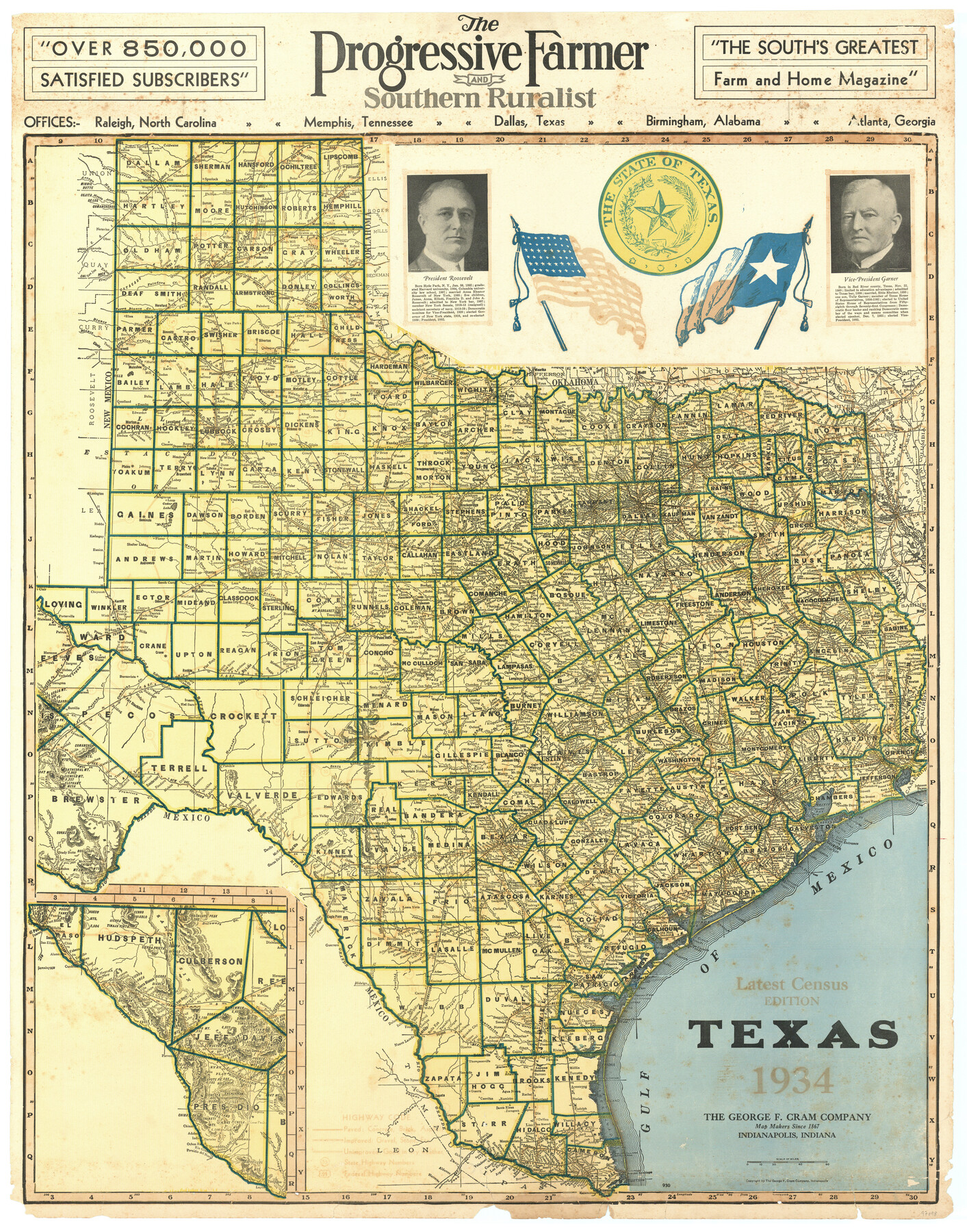
Texas
Latest Census Edition, 1934
-
Map/Doc
97098
-
Collection
General Map Collection
-
Object Dates
1934 (Creation Date)
-
People and Organizations
Jeff Bohm (Donor)
George F. Cram Company, Inc. (Publisher)
-
Subjects
State of Texas
-
Height x Width
36.4 x 28.6 inches
92.5 x 72.6 cm
-
Medium
paper, etching/engraving/lithograph
-
Comments
Donated by Jeff Bohm in February, 2023.
To view information on verso, click "Download PDF" link above.
Map features branding by "The Progressive Farmer and Southern Ruralist" magazine.
Part of: General Map Collection
Fisher County Rolled Sketch 5

Print $20.00
- Digital $50.00
Fisher County Rolled Sketch 5
1961
Size 40.3 x 32.5 inches
Map/Doc 10659
Val Verde County Working Sketch 30

Print $20.00
- Digital $50.00
Val Verde County Working Sketch 30
1938
Size 37.9 x 28.5 inches
Map/Doc 72165
Southern Part of Laguna Madre

Print $20.00
- Digital $50.00
Southern Part of Laguna Madre
1992
Size 44.9 x 35.0 inches
Map/Doc 73549
Mason County Working Sketch 24

Print $20.00
- Digital $50.00
Mason County Working Sketch 24
2008
Size 20.5 x 26.5 inches
Map/Doc 88825
Borden County Sketch File 10a

Print $40.00
- Digital $50.00
Borden County Sketch File 10a
Size 21.0 x 37.5 inches
Map/Doc 10935
Kimble County Sketch File 12

Print $5.00
- Digital $50.00
Kimble County Sketch File 12
Size 10.7 x 10.5 inches
Map/Doc 28935
Medina County Rolled Sketch 16

Print $20.00
- Digital $50.00
Medina County Rolled Sketch 16
1984
Size 44.4 x 38.0 inches
Map/Doc 9507
Jefferson County Rolled Sketch 61A

Print $20.00
- Digital $50.00
Jefferson County Rolled Sketch 61A
1928
Size 27.2 x 40.4 inches
Map/Doc 6410
Houston County Working Sketch 3

Print $20.00
- Digital $50.00
Houston County Working Sketch 3
Size 16.7 x 18.5 inches
Map/Doc 66233
Flight Mission No. DCL-7C, Frame 29, Kenedy County

Print $20.00
- Digital $50.00
Flight Mission No. DCL-7C, Frame 29, Kenedy County
1943
Size 15.3 x 15.2 inches
Map/Doc 86021
Flight Mission No. CRC-4R, Frame 178, Chambers County

Print $20.00
- Digital $50.00
Flight Mission No. CRC-4R, Frame 178, Chambers County
1956
Size 18.5 x 22.2 inches
Map/Doc 84929
Crane County Boundary File 1a

Print $18.00
- Digital $50.00
Crane County Boundary File 1a
Size 14.2 x 8.7 inches
Map/Doc 51960
You may also like
Northeast Part Presidio County

Print $20.00
- Digital $50.00
Northeast Part Presidio County
1973
Size 39.6 x 31.3 inches
Map/Doc 77398
Map of Galveston, Harrisburg & San Antonio Railway in Pecos County

Print $40.00
- Digital $50.00
Map of Galveston, Harrisburg & San Antonio Railway in Pecos County
1888
Size 26.0 x 80.9 inches
Map/Doc 64399
Lipscomb County Boundary File 9

Print $8.00
- Digital $50.00
Lipscomb County Boundary File 9
Size 11.2 x 8.5 inches
Map/Doc 56335
Hall County Sketch File B2

Print $20.00
- Digital $50.00
Hall County Sketch File B2
1904
Size 21.7 x 35.1 inches
Map/Doc 11613
[F. W. & D. C. Ry. Co. Alignment and Right of Way Map, Clay County]
![64724, [F. W. & D. C. Ry. Co. Alignment and Right of Way Map, Clay County], General Map Collection](https://historictexasmaps.com/wmedia_w700/maps/64724-1.tif.jpg)
Print $20.00
- Digital $50.00
[F. W. & D. C. Ry. Co. Alignment and Right of Way Map, Clay County]
1927
Size 18.5 x 11.7 inches
Map/Doc 64724
Navarro County Working Sketch 1b

Print $20.00
- Digital $50.00
Navarro County Working Sketch 1b
Size 32.5 x 44.6 inches
Map/Doc 71230
Tom Green County Sketch File 63

Print $20.00
- Digital $50.00
Tom Green County Sketch File 63
1890
Size 31.8 x 17.9 inches
Map/Doc 12445
Coleman County Rolled Sketch 8

Print $40.00
- Digital $50.00
Coleman County Rolled Sketch 8
1951
Size 58.8 x 40.8 inches
Map/Doc 8634
Hidalgo County Working Sketch 4

Print $20.00
- Digital $50.00
Hidalgo County Working Sketch 4
1938
Size 43.1 x 39.6 inches
Map/Doc 66181
Brewster County Working Sketch 49

Print $20.00
- Digital $50.00
Brewster County Working Sketch 49
1949
Size 37.1 x 22.6 inches
Map/Doc 67583
Outer Continental Shelf Leasing Maps (Louisiana Offshore Operations)

Print $20.00
- Digital $50.00
Outer Continental Shelf Leasing Maps (Louisiana Offshore Operations)
1959
Size 18.3 x 14.5 inches
Map/Doc 76112
[Sketch of 27 1/2 Acre Tract]
![92799, [Sketch of 27 1/2 Acre Tract], Twichell Survey Records](https://historictexasmaps.com/wmedia_w700/maps/92799-1.tif.jpg)
Print $3.00
- Digital $50.00
[Sketch of 27 1/2 Acre Tract]
1940
Size 12.4 x 9.1 inches
Map/Doc 92799