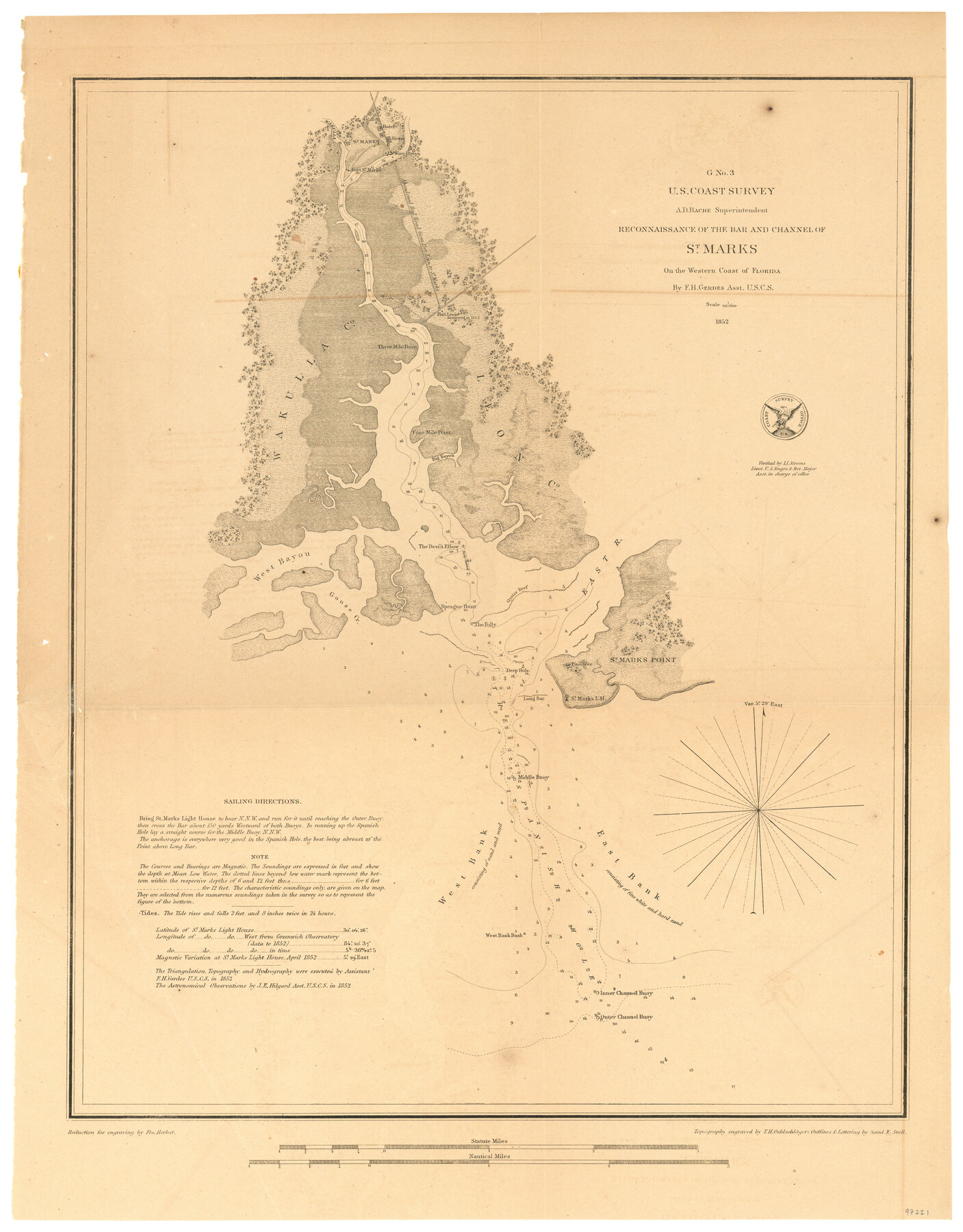
G No. 3 - Reconnaissance of the Bar and Channel of St. Marks On the Western Coast of Florida
-
Map/Doc
97221
-
Collection
General Map Collection
-
Object Dates
1852 (Creation Date)
-
People and Organizations
A.D. Bache (Superintendent)
F.H. Gerdes (Surveyor/Engineer)
U.S. Coast Survey (Publisher)
-
Subjects
Coastal
-
Height x Width
18.6 x 14.5 inches
47.2 x 36.8 cm
-
Comments
Sketch from the book "Report of the Superintendent of the Coast Survey Showing the Progress of the Survey in the year 1852" (81738)
Related maps
Report of the Superintendent of the Coast Survey showing the progress of the survey during the year 1852

Report of the Superintendent of the Coast Survey showing the progress of the survey during the year 1852
1853
Map/Doc 81738
Part of: General Map Collection
Flight Mission No. CUG-3P, Frame 166, Kleberg County

Print $20.00
- Digital $50.00
Flight Mission No. CUG-3P, Frame 166, Kleberg County
1956
Size 18.6 x 22.3 inches
Map/Doc 86286
Flight Mission No. CLL-4N, Frame 37, Willacy County

Print $20.00
- Digital $50.00
Flight Mission No. CLL-4N, Frame 37, Willacy County
1954
Size 18.4 x 22.1 inches
Map/Doc 87110
Val Verde County Sketch File 43

Print $20.00
- Digital $50.00
Val Verde County Sketch File 43
1938
Size 24.8 x 32.3 inches
Map/Doc 12585
Flight Mission No. DCL-6C, Frame 7, Kenedy County

Print $20.00
- Digital $50.00
Flight Mission No. DCL-6C, Frame 7, Kenedy County
1943
Size 18.6 x 22.4 inches
Map/Doc 85867
Gray County Sketch File 10

Print $14.00
- Digital $50.00
Gray County Sketch File 10
Size 9.7 x 6.3 inches
Map/Doc 24445
Bell County Boundary File 3

Print $24.00
- Digital $50.00
Bell County Boundary File 3
Size 11.1 x 8.6 inches
Map/Doc 50490
Flight Mission No. DQO-1K, Frame 153, Galveston County

Print $20.00
- Digital $50.00
Flight Mission No. DQO-1K, Frame 153, Galveston County
1952
Size 18.8 x 22.5 inches
Map/Doc 85006
Montgomery County Rolled Sketch 14

Print $20.00
- Digital $50.00
Montgomery County Rolled Sketch 14
Size 22.4 x 25.4 inches
Map/Doc 6803
Hays County Sketch File 19a

Print $39.00
- Digital $50.00
Hays County Sketch File 19a
1894
Size 19.4 x 28.6 inches
Map/Doc 11749
Atascosa County Sketch File 19

Print $6.00
- Digital $50.00
Atascosa County Sketch File 19
1854
Size 8.8 x 7.2 inches
Map/Doc 13784
Harrison County Sketch File 5

Print $4.00
- Digital $50.00
Harrison County Sketch File 5
1857
Size 8.1 x 9.9 inches
Map/Doc 26042

You may also like
Sutton County Sketch File 41

Print $4.00
- Digital $50.00
Sutton County Sketch File 41
1940
Size 14.4 x 8.6 inches
Map/Doc 37507
The State of Texas vs. Chas. J. Canda, et al, T. & P. Ry. Co., No. 10351

Print $522.00
- Digital $50.00
The State of Texas vs. Chas. J. Canda, et al, T. & P. Ry. Co., No. 10351
1893
Size 10.0 x 17.0 inches
Map/Doc 3048
El Paso County Rolled Sketch 22

Print $40.00
- Digital $50.00
El Paso County Rolled Sketch 22
1888
Size 38.8 x 95.1 inches
Map/Doc 8859
Flight Mission No. DAH-9M, Frame 84, Orange County

Print $20.00
- Digital $50.00
Flight Mission No. DAH-9M, Frame 84, Orange County
1953
Size 18.7 x 22.5 inches
Map/Doc 86848
Galveston County NRC Article 33.136 Location Key Sheet

Print $20.00
- Digital $50.00
Galveston County NRC Article 33.136 Location Key Sheet
1994
Size 27.0 x 23.0 inches
Map/Doc 77018
Old Miscellaneous File 39

Print $10.00
- Digital $50.00
Old Miscellaneous File 39
1893
Size 14.2 x 8.8 inches
Map/Doc 75284
Baylor County Aerial Photograph Index Sheet 1

Print $20.00
- Digital $50.00
Baylor County Aerial Photograph Index Sheet 1
1950
Size 21.4 x 17.4 inches
Map/Doc 83663
[Tie line from Northeast Block 36, Township 5N to Northwest corner Block M]
![90559, [Tie line from Northeast Block 36, Township 5N to Northwest corner Block M], Twichell Survey Records](https://historictexasmaps.com/wmedia_w700/maps/90559-1.tif.jpg)
Print $20.00
- Digital $50.00
[Tie line from Northeast Block 36, Township 5N to Northwest corner Block M]
Size 22.3 x 10.3 inches
Map/Doc 90559
Jeff Davis County Working Sketch 11

Print $20.00
- Digital $50.00
Jeff Davis County Working Sketch 11
1947
Size 23.3 x 43.1 inches
Map/Doc 66506
[Capitol Leagues in Southwest Hartley and Northwest Oldham Counties]
![90723, [Capitol Leagues in Southwest Hartley and Northwest Oldham Counties], Twichell Survey Records](https://historictexasmaps.com/wmedia_w700/maps/90723-1.tif.jpg)
Print $20.00
- Digital $50.00
[Capitol Leagues in Southwest Hartley and Northwest Oldham Counties]
Size 13.8 x 18.0 inches
Map/Doc 90723
Limestone County Sketch File 6

Print $4.00
- Digital $50.00
Limestone County Sketch File 6
1859
Size 9.2 x 8.0 inches
Map/Doc 30167
Montague County Working Sketch 14

Print $20.00
- Digital $50.00
Montague County Working Sketch 14
1940
Size 28.4 x 17.9 inches
Map/Doc 71080