Stremme General Land Office Drawings, front door

Print $20.00
Stremme General Land Office Drawings, front door
Size: 27.4 x 21.9 inches
79737
Stremme General Land Office Drawings, front view

Print $20.00
Stremme General Land Office Drawings, front view
Size: 14.0 x 20.8 inches
79738
Stremme General Land Office Drawings, side view

Print $20.00
Stremme General Land Office Drawings, side view
Size: 27.0 x 21.8 inches
79739
Spanish Province of Texas Compiled from map on file among archives at Saltillo

Print $20.00
Spanish Province of Texas Compiled from map on file among archives at Saltillo
Size: 13.8 x 16.2 inches
79742
Mappa Geographica Regionem Mexicanam et Floridam, Terrasque adjacentes, ut et Anteriores Americae Insulas, Curfus itidem et Reditus Navigantuim verfus flumen Missisipi et alias Colonias ob oculos ponens, cura et fumptibus

Print $20.00
Mappa Geographica Regionem Mexicanam et Floridam, Terrasque adjacentes, ut et Anteriores Americae Insulas, Curfus itidem et Reditus Navigantuim verfus flumen Missisipi et alias Colonias ob oculos ponens, cura et fumptibus
1725
Size: 20.0 x 24.0 inches
76196
Carte du Mexique ou de la Nouvelle Espagne

Print $20.00
Carte du Mexique ou de la Nouvelle Espagne
1750
Size: 12.4 x 15.5 inches
79741
Carte Reduite des Costes de la Louisiane et de la Floride

Print $20.00
Carte Reduite des Costes de la Louisiane et de la Floride
1764
Size: 23.3 x 35.1 inches
79295
Mapa de la Sierra Gorda y costa del Seno Mexicano desde la ciudad de Querétaro hasta la Bahía del Espíritu Santo, sus rios, ensenadas y provincias pacificadas por Don José de Escandón

Print $20.00
Mapa de la Sierra Gorda y costa del Seno Mexicano desde la ciudad de Querétaro hasta la Bahía del Espíritu Santo, sus rios, ensenadas y provincias pacificadas por Don José de Escandón
1792
Size: 21.4 x 16.8 inches
89047
The Continent and Islands of the West Indies

Print $20.00
The Continent and Islands of the West Indies
1804
Size: 22.8 x 26.0 inches
79318
A Map of the Internal Provinces of New Spain

Print $20.00
A Map of the Internal Provinces of New Spain
1807
Size: 18.9 x 19.5 inches
76234
A Chart of the Internal Part of Louisiana

Print $20.00
A Chart of the Internal Part of Louisiana
1807
Size: 19.2 x 16.5 inches
79310
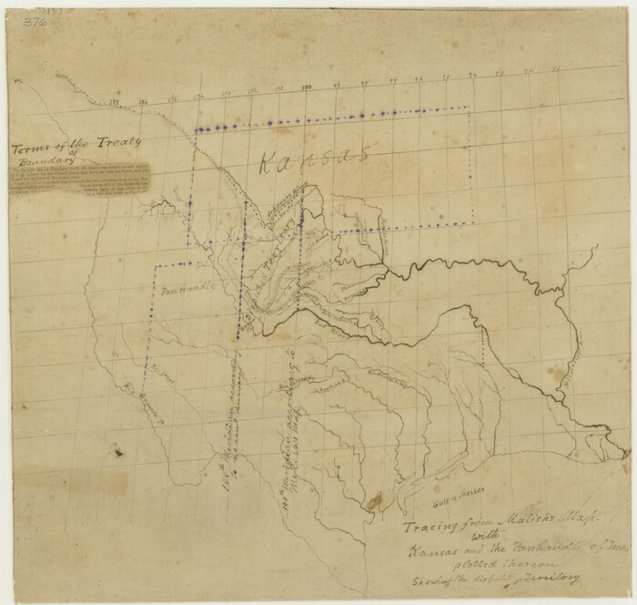
Tracing From [Melish's] Map with Kansas and the Panhandle of Texas plotted thereon Showing the disputed Territory
Print $20.00
Tracing From [Melish's] Map with Kansas and the Panhandle of Texas plotted thereon Showing the disputed Territory
1818
Size: 18.8 x 19.8 inches
76190
A Map of Louisiana and Mexico

Print $20.00
A Map of Louisiana and Mexico
1820
Size: 43.0 x 32.6 inches
76218
Mexico and Internal Provinces

Print $20.00
Mexico and Internal Provinces
1822
Size: 17.8 x 22.5 inches
76189
Carte Geographique, Statistique et Historique du Mexique

Print $20.00
Carte Geographique, Statistique et Historique du Mexique
1824
Size: 22.3 x 28.1 inches
79315
Mapa de los Estados Unidos de Méjico, Segun lo organizado y definido por las varias actas del Congreso de dicha Republica: y construido por las mejores autoridades

Print $20.00
Mapa de los Estados Unidos de Méjico, Segun lo organizado y definido por las varias actas del Congreso de dicha Republica: y construido por las mejores autoridades
1828
Size: 29.3 x 41.6 inches
76217
Mapa Original de Texas por El Ciudadano Estevan F. Austin Presentado al Exmo. Sr. Presidente por su autor 1829

Print $20.00
Mapa Original de Texas por El Ciudadano Estevan F. Austin Presentado al Exmo. Sr. Presidente por su autor 1829
1829
Size: 33.4 x 28.1 inches
76201
Mexico and Internal Provinces

Print $20.00
Mexico and Internal Provinces
1829
Size: 12.9 x 14.5 inches
79733
Mapa de los Estados Unidos Mejicanos

Print $20.00
Mapa de los Estados Unidos Mejicanos
1831
Size: 24.7 x 29.7 inches
79291
Map of the State of Coahuila and Texas

Print $20.00
Map of the State of Coahuila and Texas
1833
Size: 16.1 x 20.2 inches
76246
Map of Texas with Parts of the Adjoining States

Print $20.00
Map of Texas with Parts of the Adjoining States
1833
Size: 29.3 x 23.3 inches
79740

Mitchell's Travellers Guide Through the United States. A Map of the Roads, Distances, Steam Boat, and Canal Routes etc.

Print $20.00
Mitchell's Travellers Guide Through the United States. A Map of the Roads, Distances, Steam Boat, and Canal Routes etc.
1834
Size: 18.2 x 22.6 inches
79314
A New Map of Texas with the Contiguous American & Mexican States

Print $20.00
A New Map of Texas with the Contiguous American & Mexican States
1835
Size: 13.5 x 16.1 inches
76185
Mitchell's Travellers Guide Through the United States. A Map of the Roads, Distances, Steam Boat, and Canal Routes etc.

Print $20.00
Mitchell's Travellers Guide Through the United States. A Map of the Roads, Distances, Steam Boat, and Canal Routes etc.
1835
Size: 18.0 x 22.7 inches
79723
Map of the United States of America with its territories and districts including also a part of upper and lower Canada and Mexico

Print $20.00
Map of the United States of America with its territories and districts including also a part of upper and lower Canada and Mexico
1835
Size: 30.3 x 43.2 inches
79728
Map of Texas with Parts of the Adjoining States

Print $20.00
Map of Texas with Parts of the Adjoining States
1836
Size: 29.5 x 23.6 inches
76193
Map of Texas Containing the Latest Grants and Discoveries

Print $20.00
Map of Texas Containing the Latest Grants and Discoveries
1836
Size: 16.2 x 10.6 inches
76245
Map of Texas, compiled from surveys on record in the General Land Office of the Republic

Print $20.00
Map of Texas, compiled from surveys on record in the General Land Office of the Republic
1839
Size: 32.0 x 24.9 inches
76198
Stremme General Land Office Drawings, front door
Print $20.00
Stremme General Land Office Drawings, front door
-
Size
27.4 x 21.9 inches
-
Map/Doc
79737
Stremme General Land Office Drawings, front view
Print $20.00
Stremme General Land Office Drawings, front view
-
Size
14.0 x 20.8 inches
-
Map/Doc
79738
Stremme General Land Office Drawings, side view
Print $20.00
Stremme General Land Office Drawings, side view
-
Size
27.0 x 21.8 inches
-
Map/Doc
79739
Spanish Province of Texas Compiled from map on file among archives at Saltillo
Print $20.00
Spanish Province of Texas Compiled from map on file among archives at Saltillo
-
Size
13.8 x 16.2 inches
-
Map/Doc
79742
Mappa Geographica Regionem Mexicanam et Floridam, Terrasque adjacentes, ut et Anteriores Americae Insulas, Curfus itidem et Reditus Navigantuim verfus flumen Missisipi et alias Colonias ob oculos ponens, cura et fumptibus
Print $20.00
Mappa Geographica Regionem Mexicanam et Floridam, Terrasque adjacentes, ut et Anteriores Americae Insulas, Curfus itidem et Reditus Navigantuim verfus flumen Missisipi et alias Colonias ob oculos ponens, cura et fumptibus
1725
-
Size
20.0 x 24.0 inches
-
Map/Doc
76196
-
Creation Date
1725
Carte du Mexique ou de la Nouvelle Espagne
Print $20.00
Carte du Mexique ou de la Nouvelle Espagne
1750
-
Size
12.4 x 15.5 inches
-
Map/Doc
79741
-
Creation Date
1750
Carte Reduite des Costes de la Louisiane et de la Floride
Print $20.00
Carte Reduite des Costes de la Louisiane et de la Floride
1764
-
Size
23.3 x 35.1 inches
-
Map/Doc
79295
-
Creation Date
1764
Mapa de la Sierra Gorda y costa del Seno Mexicano desde la ciudad de Querétaro hasta la Bahía del Espíritu Santo, sus rios, ensenadas y provincias pacificadas por Don José de Escandón
Print $20.00
Mapa de la Sierra Gorda y costa del Seno Mexicano desde la ciudad de Querétaro hasta la Bahía del Espíritu Santo, sus rios, ensenadas y provincias pacificadas por Don José de Escandón
1792
-
Size
21.4 x 16.8 inches
-
Map/Doc
89047
-
Creation Date
1792
The Continent and Islands of the West Indies
Print $20.00
The Continent and Islands of the West Indies
1804
-
Size
22.8 x 26.0 inches
-
Map/Doc
79318
-
Creation Date
1804
A Map of the Internal Provinces of New Spain
Print $20.00
A Map of the Internal Provinces of New Spain
1807
-
Size
18.9 x 19.5 inches
-
Map/Doc
76234
-
Creation Date
1807
A Chart of the Internal Part of Louisiana
Print $20.00
A Chart of the Internal Part of Louisiana
1807
-
Size
19.2 x 16.5 inches
-
Map/Doc
79310
-
Creation Date
1807
Mexico or New Spain

Print $20.00
Mexico or New Spain
1814
-
Size
19.8 x 17.2 inches
-
Map/Doc
79313
-
Creation Date
1814
Tracing From [Melish's] Map with Kansas and the Panhandle of Texas plotted thereon Showing the disputed Territory
Print $20.00
Tracing From [Melish's] Map with Kansas and the Panhandle of Texas plotted thereon Showing the disputed Territory
1818
-
Size
18.8 x 19.8 inches
-
Map/Doc
76190
-
Creation Date
1818
A Map of Louisiana and Mexico
Print $20.00
A Map of Louisiana and Mexico
1820
-
Size
43.0 x 32.6 inches
-
Map/Doc
76218
-
Creation Date
1820
Mexico and Internal Provinces
Print $20.00
Mexico and Internal Provinces
1822
-
Size
17.8 x 22.5 inches
-
Map/Doc
76189
-
Creation Date
1822
Carte Geographique, Statistique et Historique du Mexique
Print $20.00
Carte Geographique, Statistique et Historique du Mexique
1824
-
Size
22.3 x 28.1 inches
-
Map/Doc
79315
-
Creation Date
1824
Mapa de los Estados Unidos de Méjico, Segun lo organizado y definido por las varias actas del Congreso de dicha Republica: y construido por las mejores autoridades
Print $20.00
Mapa de los Estados Unidos de Méjico, Segun lo organizado y definido por las varias actas del Congreso de dicha Republica: y construido por las mejores autoridades
1828
-
Size
29.3 x 41.6 inches
-
Map/Doc
76217
-
Creation Date
1828
Mapa Original de Texas por El Ciudadano Estevan F. Austin Presentado al Exmo. Sr. Presidente por su autor 1829
Print $20.00
Mapa Original de Texas por El Ciudadano Estevan F. Austin Presentado al Exmo. Sr. Presidente por su autor 1829
1829
-
Size
33.4 x 28.1 inches
-
Map/Doc
76201
-
Creation Date
1829
Mexico and Internal Provinces
Print $20.00
Mexico and Internal Provinces
1829
-
Size
12.9 x 14.5 inches
-
Map/Doc
79733
-
Creation Date
1829
Mapa de los Estados Unidos Mejicanos
Print $20.00
Mapa de los Estados Unidos Mejicanos
1831
-
Size
24.7 x 29.7 inches
-
Map/Doc
79291
-
Creation Date
1831
Map of the State of Coahuila and Texas
Print $20.00
Map of the State of Coahuila and Texas
1833
-
Size
16.1 x 20.2 inches
-
Map/Doc
76246
-
Creation Date
1833
Map of Texas with Parts of the Adjoining States
Print $20.00
Map of Texas with Parts of the Adjoining States
1833
-
Size
29.3 x 23.3 inches
-
Map/Doc
79740
-
Creation Date
1833
Mitchell's Travellers Guide Through the United States. A Map of the Roads, Distances, Steam Boat, and Canal Routes etc.
Print $20.00
Mitchell's Travellers Guide Through the United States. A Map of the Roads, Distances, Steam Boat, and Canal Routes etc.
1834
-
Size
18.2 x 22.6 inches
-
Map/Doc
79314
-
Creation Date
1834
A New Map of Texas with the Contiguous American & Mexican States
Print $20.00
A New Map of Texas with the Contiguous American & Mexican States
1835
-
Size
13.5 x 16.1 inches
-
Map/Doc
76185
-
Creation Date
1835
Mitchell's Travellers Guide Through the United States. A Map of the Roads, Distances, Steam Boat, and Canal Routes etc.
Print $20.00
Mitchell's Travellers Guide Through the United States. A Map of the Roads, Distances, Steam Boat, and Canal Routes etc.
1835
-
Size
18.0 x 22.7 inches
-
Map/Doc
79723
-
Creation Date
1835
Map of the United States of America with its territories and districts including also a part of upper and lower Canada and Mexico
Print $20.00
Map of the United States of America with its territories and districts including also a part of upper and lower Canada and Mexico
1835
-
Size
30.3 x 43.2 inches
-
Map/Doc
79728
-
Creation Date
1835
Map of Texas with Parts of the Adjoining States
Print $20.00
Map of Texas with Parts of the Adjoining States
1836
-
Size
29.5 x 23.6 inches
-
Map/Doc
76193
-
Creation Date
1836
Map of Texas Containing the Latest Grants and Discoveries
Print $20.00
Map of Texas Containing the Latest Grants and Discoveries
1836
-
Size
16.2 x 10.6 inches
-
Map/Doc
76245
-
Creation Date
1836
Map of Texas, compiled from surveys on record in the General Land Office of the Republic
Print $20.00
Map of Texas, compiled from surveys on record in the General Land Office of the Republic
1839
-
Size
32.0 x 24.9 inches
-
Map/Doc
76198
-
Creation Date
1839