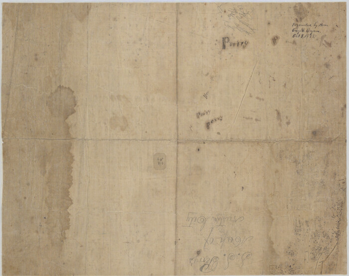
[Reverse of] Plan of the City of Austin
Print $20.00
[Reverse of] Plan of the City of Austin
1839
Size: 19.2 x 24.3 inches
76228
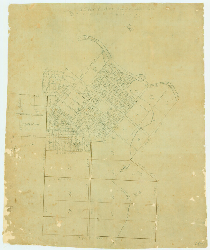
[Plat of Victoria, Texas]
Print $20.00
[Plat of Victoria, Texas]
1850
Size: 14.1 x 11.5 inches
76270
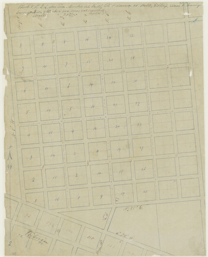
[Plat of San Marcos, Texas]
Print $20.00
[Plat of San Marcos, Texas]
1890
Size: 18.9 x 15.9 inches
79312
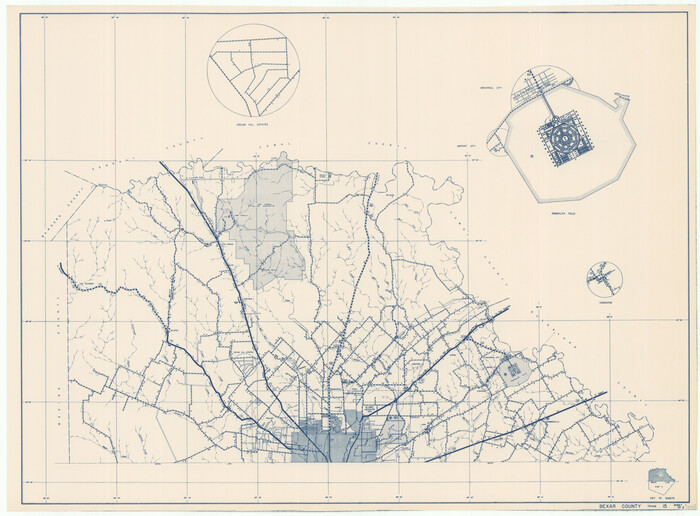
[General Highway Map of] Bexar County, Sheet 1 of 2
Print $20.00
[General Highway Map of] Bexar County, Sheet 1 of 2
1940
Size: 18.5 x 25.1 inches
76288
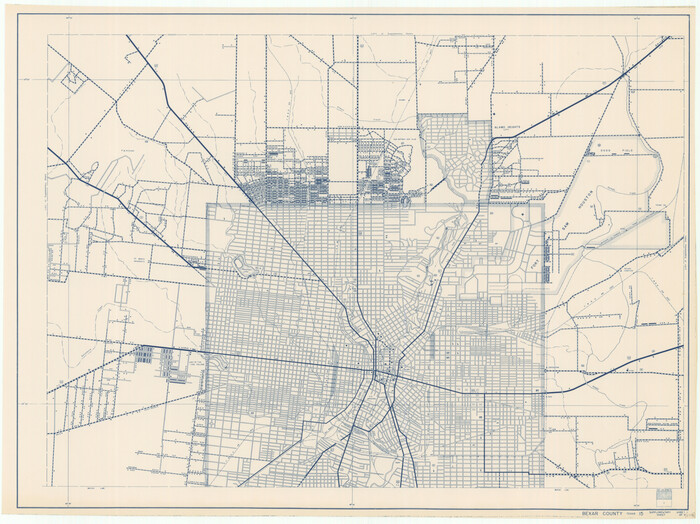
[General Highway Map Supplementary Sheet Showing Detail of Cities and Towns in Bexar County Texas]
Print $20.00
[General Highway Map Supplementary Sheet Showing Detail of Cities and Towns in Bexar County Texas]
1936
Size: 18.7 x 24.9 inches
76289
Worley's Map of Greater Dallas

Print $20.00
Worley's Map of Greater Dallas
1905
Size: 34.9 x 25.4 inches
79319
Waco Village, County Seat of McLennan County

Print $20.00
Waco Village, County Seat of McLennan County
1850
Size: 15.8 x 12.4 inches
76268
United States Including California, Texas, and c.

Print $20.00
United States Including California, Texas, and c.
1861
Size: 21.4 x 25.7 inches
76238
Traveller's Map of the State of Texas

Print $20.00
Traveller's Map of the State of Texas
1867
Size: 42.5 x 41.1 inches
76226
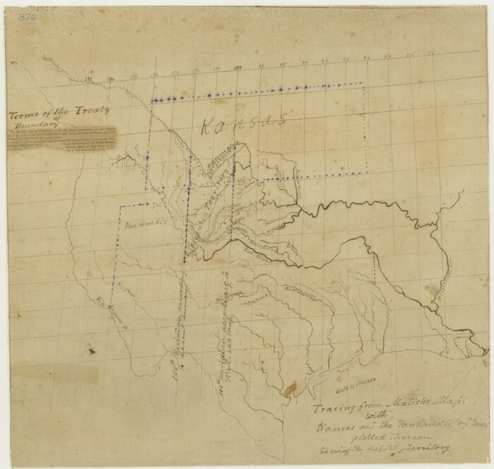
Tracing From [Melish's] Map with Kansas and the Panhandle of Texas plotted thereon Showing the disputed Territory
Print $20.00
Tracing From [Melish's] Map with Kansas and the Panhandle of Texas plotted thereon Showing the disputed Territory
1818
Size: 18.8 x 19.8 inches
76190
Town of Lubbock, Texas and Additions

Print $20.00
Town of Lubbock, Texas and Additions
1935
Size: 43.8 x 43.5 inches
76271
Town of Beaumont in Jefferson County, Texas

Print $20.00
Town of Beaumont in Jefferson County, Texas
1850
Size: 17.6 x 24.3 inches
76267
Topographisch-geognostische Karte von Texas

Print $20.00
Topographisch-geognostische Karte von Texas
1849
Size: 23.8 x 21.1 inches
76241
Topographic Map of Texas and Oklahoma Boundary, Fort Augur Area

Print $20.00
Topographic Map of Texas and Oklahoma Boundary, Fort Augur Area
1924
Size: 22.1 x 38.3 inches
79752
Topographic Map of Texas and Oklahoma Boundary, Fort Augur Area

Print $20.00
Topographic Map of Texas and Oklahoma Boundary, Fort Augur Area
1924
Size: 20.3 x 33.0 inches
79753
Topographic Map of Texas and Oklahoma Boundary, Fort Augur Area

Print $20.00
Topographic Map of Texas and Oklahoma Boundary, Fort Augur Area
1924
Size: 17.2 x 33.7 inches
79754
Topographic Map of Texas and Oklahoma Boundary, Fort Augur Area

Print $20.00
Topographic Map of Texas and Oklahoma Boundary, Fort Augur Area
1924
Size: 32.3 x 33.8 inches
79755
Topographic Map of Big Bend Area

Print $40.00
Topographic Map of Big Bend Area
1923
Size: 59.0 x 35.4 inches
79756
Topographic Map of Big Bend Area

Print $20.00
Topographic Map of Big Bend Area
1923
Size: 47.1 x 35.0 inches
79757
Topographic Map of Big Bend Area

Print $20.00
Topographic Map of Big Bend Area
1923
Size: 35.5 x 40.7 inches
79758
Topographic Map of Big Bend Area

Print $20.00
Topographic Map of Big Bend Area
1923
Size: 40.1 x 40.3 inches
79759
The Texas and Oklahoma Official Railway and Hotel Guide Map

Print $20.00
The Texas and Oklahoma Official Railway and Hotel Guide Map
1912
Size: 23.4 x 23.9 inches
76276
The Texas and Oklahoma Official Railway and Hotel Guide Map

Print $20.00
The Texas and Oklahoma Official Railway and Hotel Guide Map
1906
Size: 23.5 x 23.4 inches
79316
The Texas New Yorker's Map of the U. S. Accompanying the Map of Texas

Print $20.00
The Texas New Yorker's Map of the U. S. Accompanying the Map of Texas
1874
Size: 32.3 x 22.8 inches
76211
The Federal Aid Highway System Progress Map

Print $20.00
The Federal Aid Highway System Progress Map
1931
Size: 31.4 x 22.1 inches
79745
The Continent and Islands of the West Indies

Print $20.00
The Continent and Islands of the West Indies
1804
Size: 22.8 x 26.0 inches
79318
The City of Austin and Suburbs

Print $20.00
The City of Austin and Suburbs
1919
Size: 24.1 x 19.1 inches
76203
That Part of Disturnell's Treaty Map in the Vicinity of the Rio Grande and Southern Boundary of New Mexico

Print $20.00
That Part of Disturnell's Treaty Map in the Vicinity of the Rio Grande and Southern Boundary of New Mexico
1851
Size: 10.7 x 12.9 inches
76285
[Town Plat of Galveston]
![76258, [Town Plat of Galveston], Texas State Library and Archives](https://historictexasmaps.com/wmedia_w700/maps/76258.tif.jpg)
Print $20.00
[Town Plat of Galveston]
1877
-
Size
9.1 x 14.5 inches
-
Map/Doc
76258
-
Creation Date
1877
[Reverse of] Plan of the City of Austin
Print $20.00
[Reverse of] Plan of the City of Austin
1839
-
Size
19.2 x 24.3 inches
-
Map/Doc
76228
-
Creation Date
1839
[Plat of Victoria, Texas]
Print $20.00
[Plat of Victoria, Texas]
1850
-
Size
14.1 x 11.5 inches
-
Map/Doc
76270
-
Creation Date
1850
[Plat of San Marcos, Texas]
Print $20.00
[Plat of San Marcos, Texas]
1890
-
Size
18.9 x 15.9 inches
-
Map/Doc
79312
-
Creation Date
1890
[General Highway Map of] Bexar County, Sheet 1 of 2
Print $20.00
[General Highway Map of] Bexar County, Sheet 1 of 2
1940
-
Size
18.5 x 25.1 inches
-
Map/Doc
76288
-
Creation Date
1940
[General Highway Map Supplementary Sheet Showing Detail of Cities and Towns in Bexar County Texas]
Print $20.00
[General Highway Map Supplementary Sheet Showing Detail of Cities and Towns in Bexar County Texas]
1936
-
Size
18.7 x 24.9 inches
-
Map/Doc
76289
-
Creation Date
1936
Worley's Map of Greater Dallas
Print $20.00
Worley's Map of Greater Dallas
1905
-
Size
34.9 x 25.4 inches
-
Map/Doc
79319
-
Creation Date
1905
Waco Village, County Seat of McLennan County
Print $20.00
Waco Village, County Seat of McLennan County
1850
-
Size
15.8 x 12.4 inches
-
Map/Doc
76268
-
Creation Date
1850
United States Including California, Texas, and c.
Print $20.00
United States Including California, Texas, and c.
1861
-
Size
21.4 x 25.7 inches
-
Map/Doc
76238
-
Creation Date
1861
Traveller's Map of the State of Texas
Print $20.00
Traveller's Map of the State of Texas
1867
-
Size
42.5 x 41.1 inches
-
Map/Doc
76226
-
Creation Date
1867
Tracing From [Melish's] Map with Kansas and the Panhandle of Texas plotted thereon Showing the disputed Territory
Print $20.00
Tracing From [Melish's] Map with Kansas and the Panhandle of Texas plotted thereon Showing the disputed Territory
1818
-
Size
18.8 x 19.8 inches
-
Map/Doc
76190
-
Creation Date
1818
Town of San Marcos

Print $20.00
Town of San Marcos
1881
-
Size
15.6 x 15.2 inches
-
Map/Doc
76237
-
Creation Date
1881
Town of Lubbock, Texas and Additions
Print $20.00
Town of Lubbock, Texas and Additions
1935
-
Size
43.8 x 43.5 inches
-
Map/Doc
76271
-
Creation Date
1935
Town of Beaumont in Jefferson County, Texas
Print $20.00
Town of Beaumont in Jefferson County, Texas
1850
-
Size
17.6 x 24.3 inches
-
Map/Doc
76267
-
Creation Date
1850
Topographisch-geognostische Karte von Texas
Print $20.00
Topographisch-geognostische Karte von Texas
1849
-
Size
23.8 x 21.1 inches
-
Map/Doc
76241
-
Creation Date
1849
Topographic Map of Texas and Oklahoma Boundary, Fort Augur Area
Print $20.00
Topographic Map of Texas and Oklahoma Boundary, Fort Augur Area
1924
-
Size
22.1 x 38.3 inches
-
Map/Doc
79752
-
Creation Date
1924
Topographic Map of Texas and Oklahoma Boundary, Fort Augur Area
Print $20.00
Topographic Map of Texas and Oklahoma Boundary, Fort Augur Area
1924
-
Size
20.3 x 33.0 inches
-
Map/Doc
79753
-
Creation Date
1924
Topographic Map of Texas and Oklahoma Boundary, Fort Augur Area
Print $20.00
Topographic Map of Texas and Oklahoma Boundary, Fort Augur Area
1924
-
Size
17.2 x 33.7 inches
-
Map/Doc
79754
-
Creation Date
1924
Topographic Map of Texas and Oklahoma Boundary, Fort Augur Area
Print $20.00
Topographic Map of Texas and Oklahoma Boundary, Fort Augur Area
1924
-
Size
32.3 x 33.8 inches
-
Map/Doc
79755
-
Creation Date
1924
Topographic Map of Big Bend Area
Print $40.00
Topographic Map of Big Bend Area
1923
-
Size
59.0 x 35.4 inches
-
Map/Doc
79756
-
Creation Date
1923
Topographic Map of Big Bend Area
Print $20.00
Topographic Map of Big Bend Area
1923
-
Size
47.1 x 35.0 inches
-
Map/Doc
79757
-
Creation Date
1923
Topographic Map of Big Bend Area
Print $20.00
Topographic Map of Big Bend Area
1923
-
Size
35.5 x 40.7 inches
-
Map/Doc
79758
-
Creation Date
1923
Topographic Map of Big Bend Area
Print $20.00
Topographic Map of Big Bend Area
1923
-
Size
40.1 x 40.3 inches
-
Map/Doc
79759
-
Creation Date
1923
The Texas and Oklahoma Official Railway and Hotel Guide Map
Print $20.00
The Texas and Oklahoma Official Railway and Hotel Guide Map
1912
-
Size
23.4 x 23.9 inches
-
Map/Doc
76276
-
Creation Date
1912
The Texas and Oklahoma Official Railway and Hotel Guide Map
Print $20.00
The Texas and Oklahoma Official Railway and Hotel Guide Map
1906
-
Size
23.5 x 23.4 inches
-
Map/Doc
79316
-
Creation Date
1906
The Texas New Yorker's Map of the U. S. Accompanying the Map of Texas
Print $20.00
The Texas New Yorker's Map of the U. S. Accompanying the Map of Texas
1874
-
Size
32.3 x 22.8 inches
-
Map/Doc
76211
-
Creation Date
1874
The Federal Aid Highway System Progress Map
Print $20.00
The Federal Aid Highway System Progress Map
1931
-
Size
31.4 x 22.1 inches
-
Map/Doc
79745
-
Creation Date
1931
The Continent and Islands of the West Indies
Print $20.00
The Continent and Islands of the West Indies
1804
-
Size
22.8 x 26.0 inches
-
Map/Doc
79318
-
Creation Date
1804
The City of Austin and Suburbs
Print $20.00
The City of Austin and Suburbs
1919
-
Size
24.1 x 19.1 inches
-
Map/Doc
76203
-
Creation Date
1919
That Part of Disturnell's Treaty Map in the Vicinity of the Rio Grande and Southern Boundary of New Mexico
Print $20.00
That Part of Disturnell's Treaty Map in the Vicinity of the Rio Grande and Southern Boundary of New Mexico
1851
-
Size
10.7 x 12.9 inches
-
Map/Doc
76285
-
Creation Date
1851