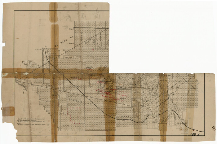
[Sketch showing Jeff Davis County, Blocks 1, 2, 3, 4, 360, 363 and JG1]
Print $20.00
- Digital $50.00
[Sketch showing Jeff Davis County, Blocks 1, 2, 3, 4, 360, 363 and JG1]
Size: 20.5 x 13.7 inches
91776
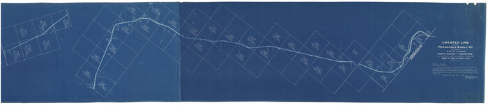
[Kansas City, Mexico & Orient] Located Line of the Panhandle and Gulf RY. Through Stand Lands, Public School and University, In Presidio County Texas, Right of Way 200 feet Wide
Print $40.00
- Digital $50.00
[Kansas City, Mexico & Orient] Located Line of the Panhandle and Gulf RY. Through Stand Lands, Public School and University, In Presidio County Texas, Right of Way 200 feet Wide
1904
Size: 15.6 x 70.3 inches
64269
Texas Coordinate File 4

Print $44.00
- Digital $50.00
Texas Coordinate File 4
Size: 11.4 x 9.1 inches
75308
Terrell County Working Sketch 82

Print $20.00
- Digital $50.00
Terrell County Working Sketch 82
1991
Size: 31.7 x 24.8 inches
69603
Terrell County Sketch File 42

Print $20.00
- Digital $50.00
Terrell County Sketch File 42
1885
97199
Terrell County Sketch File 20

Print $6.00
- Digital $50.00
Terrell County Sketch File 20
1910
Size: 10.9 x 12.6 inches
37946
Terrell County Sketch File 19

Print $6.00
- Digital $50.00
Terrell County Sketch File 19
1910
Size: 10.2 x 12.1 inches
37944
Terrell County Sketch File 18

Print $8.00
- Digital $50.00
Terrell County Sketch File 18
1908
Size: 9.1 x 4.4 inches
37941
Terrell County Sketch File 17

Print $13.00
- Digital $50.00
Terrell County Sketch File 17
Size: 10.1 x 8.1 inches
37935
Terrell County Sketch File 13

Print $20.00
- Digital $50.00
Terrell County Sketch File 13
1911
Size: 13.7 x 20.4 inches
12420
Terrell County Sketch File 1

Print $78.00
- Digital $50.00
Terrell County Sketch File 1
1881
Size: 9.1 x 8.8 inches
37870
Terlingua Special Map, The University of Texas Mineral Survey, Brewster County, Texas

Print $20.00
- Digital $50.00
Terlingua Special Map, The University of Texas Mineral Survey, Brewster County, Texas
1902
Size: 20.4 x 22.6 inches
482
Tascotal Mesa Quadrangle

Print $20.00
- Digital $50.00
Tascotal Mesa Quadrangle
1917
Size: 17.0 x 20.7 inches
90134
South Part of Brewster Co.

Print $40.00
- Digital $50.00
South Part of Brewster Co.
1955
Size: 49.3 x 41.3 inches
66735
South Part of Brewster Co.

Print $40.00
- Digital $50.00
South Part of Brewster Co.
1955
Size: 48.8 x 40.0 inches
66736
South Part of Brewster Co.

Print $40.00
- Digital $50.00
South Part of Brewster Co.
1955
Size: 48.2 x 40.5 inches
73089
South Part of Brewster Co.

Print $20.00
- Digital $50.00
South Part of Brewster Co.
1955
Size: 47.3 x 39.6 inches
77221
South Part of Brewster Co.

Print $40.00
- Digital $50.00
South Part of Brewster Co.
1955
Size: 48.9 x 41.4 inches
95438
South Part Brewster Co.

Print $40.00
- Digital $50.00
South Part Brewster Co.
1915
Size: 39.2 x 51.8 inches
4760
South Part Brewster Co.

Print $40.00
- Digital $50.00
South Part Brewster Co.
Size: 36.5 x 51.5 inches
66723
South Part Brewster Co.

Print $40.00
- Digital $50.00
South Part Brewster Co.
Size: 35.2 x 49.8 inches
66724
South Part Brewster Co.

Print $40.00
- Digital $50.00
South Part Brewster Co.
1910
Size: 32.0 x 49.7 inches
66728
South Part Brewster Co.

Print $40.00
- Digital $50.00
South Part Brewster Co.
1915
Size: 36.0 x 51.2 inches
66733
South Part Brewster Co.

Print $40.00
- Digital $50.00
South Part Brewster Co.
1915
Size: 50.0 x 35.2 inches
89723
South Part Brewster Co.

Print $40.00
- Digital $50.00
South Part Brewster Co.
Size: 48.7 x 32.8 inches
92468
Revised Sectional Map No. 6 showing land surveys in parts of Presidio and Brewster Counties, Texas

Print $20.00
- Digital $50.00
Revised Sectional Map No. 6 showing land surveys in parts of Presidio and Brewster Counties, Texas
Size: 24.2 x 23.0 inches
4475
Revised Sectional Map No. 5 showing land surveys in parts of counties of El Paso, Jeff Davis, Presidio and Brewster, Texas

Print $20.00
- Digital $50.00
Revised Sectional Map No. 5 showing land surveys in parts of counties of El Paso, Jeff Davis, Presidio and Brewster, Texas
Size: 19.0 x 23.7 inches
4476
Presidio County Working Sketch 63

Print $40.00
- Digital $50.00
Presidio County Working Sketch 63
1958
Size: 64.8 x 38.9 inches
71740
Presidio County Working Sketch 44

Print $20.00
- Digital $50.00
Presidio County Working Sketch 44
1949
Size: 29.8 x 20.6 inches
71721
[Sketch showing Jeff Davis County, Blocks 1, 2, 3, 4, 360, 363 and JG1]
Print $20.00
- Digital $50.00
[Sketch showing Jeff Davis County, Blocks 1, 2, 3, 4, 360, 363 and JG1]
-
Size
20.5 x 13.7 inches
-
Map/Doc
91776
[Kansas City, Mexico & Orient] Located Line of the Panhandle and Gulf RY. Through Stand Lands, Public School and University, In Presidio County Texas, Right of Way 200 feet Wide
Print $40.00
- Digital $50.00
[Kansas City, Mexico & Orient] Located Line of the Panhandle and Gulf RY. Through Stand Lands, Public School and University, In Presidio County Texas, Right of Way 200 feet Wide
1904
-
Size
15.6 x 70.3 inches
-
Map/Doc
64269
-
Creation Date
1904
Texas Coordinate File 4
Print $44.00
- Digital $50.00
Texas Coordinate File 4
-
Size
11.4 x 9.1 inches
-
Map/Doc
75308
Terrell County Working Sketch 82
Print $20.00
- Digital $50.00
Terrell County Working Sketch 82
1991
-
Size
31.7 x 24.8 inches
-
Map/Doc
69603
-
Creation Date
1991
Terrell County Sketch File 42
Print $20.00
- Digital $50.00
Terrell County Sketch File 42
1885
-
Map/Doc
97199
-
Creation Date
1885
Terrell County Sketch File 4

Print $12.00
- Digital $50.00
Terrell County Sketch File 4
1881
-
Map/Doc
12417
-
Creation Date
1881
Terrell County Sketch File 20
Print $6.00
- Digital $50.00
Terrell County Sketch File 20
1910
-
Size
10.9 x 12.6 inches
-
Map/Doc
37946
-
Creation Date
1910
Terrell County Sketch File 19
Print $6.00
- Digital $50.00
Terrell County Sketch File 19
1910
-
Size
10.2 x 12.1 inches
-
Map/Doc
37944
-
Creation Date
1910
Terrell County Sketch File 18
Print $8.00
- Digital $50.00
Terrell County Sketch File 18
1908
-
Size
9.1 x 4.4 inches
-
Map/Doc
37941
-
Creation Date
1908
Terrell County Sketch File 17
Print $13.00
- Digital $50.00
Terrell County Sketch File 17
-
Size
10.1 x 8.1 inches
-
Map/Doc
37935
Terrell County Sketch File 13
Print $20.00
- Digital $50.00
Terrell County Sketch File 13
1911
-
Size
13.7 x 20.4 inches
-
Map/Doc
12420
-
Creation Date
1911
Terrell County Sketch File 1
Print $78.00
- Digital $50.00
Terrell County Sketch File 1
1881
-
Size
9.1 x 8.8 inches
-
Map/Doc
37870
-
Creation Date
1881
Terlingua Special Map, The University of Texas Mineral Survey, Brewster County, Texas
Print $20.00
- Digital $50.00
Terlingua Special Map, The University of Texas Mineral Survey, Brewster County, Texas
1902
-
Size
20.4 x 22.6 inches
-
Map/Doc
482
-
Creation Date
1902
Tascotal Mesa Quadrangle
Print $20.00
- Digital $50.00
Tascotal Mesa Quadrangle
1917
-
Size
17.0 x 20.7 inches
-
Map/Doc
90134
-
Creation Date
1917
South Part of Brewster Co.
Print $40.00
- Digital $50.00
South Part of Brewster Co.
1955
-
Size
49.3 x 41.3 inches
-
Map/Doc
66735
-
Creation Date
1955
South Part of Brewster Co.
Print $40.00
- Digital $50.00
South Part of Brewster Co.
1955
-
Size
48.8 x 40.0 inches
-
Map/Doc
66736
-
Creation Date
1955
South Part of Brewster Co.
Print $40.00
- Digital $50.00
South Part of Brewster Co.
1955
-
Size
48.2 x 40.5 inches
-
Map/Doc
73089
-
Creation Date
1955
South Part of Brewster Co.
Print $20.00
- Digital $50.00
South Part of Brewster Co.
1955
-
Size
47.3 x 39.6 inches
-
Map/Doc
77221
-
Creation Date
1955
South Part of Brewster Co.
Print $40.00
- Digital $50.00
South Part of Brewster Co.
1955
-
Size
48.9 x 41.4 inches
-
Map/Doc
95438
-
Creation Date
1955
South Part Brewster Co.
Print $40.00
- Digital $50.00
South Part Brewster Co.
1915
-
Size
39.2 x 51.8 inches
-
Map/Doc
4760
-
Creation Date
1915
South Part Brewster Co.
Print $40.00
- Digital $50.00
South Part Brewster Co.
-
Size
36.5 x 51.5 inches
-
Map/Doc
66723
South Part Brewster Co.
Print $40.00
- Digital $50.00
South Part Brewster Co.
-
Size
35.2 x 49.8 inches
-
Map/Doc
66724
South Part Brewster Co.
Print $40.00
- Digital $50.00
South Part Brewster Co.
1910
-
Size
32.0 x 49.7 inches
-
Map/Doc
66728
-
Creation Date
1910
South Part Brewster Co.
Print $40.00
- Digital $50.00
South Part Brewster Co.
1915
-
Size
36.0 x 51.2 inches
-
Map/Doc
66733
-
Creation Date
1915
South Part Brewster Co.
Print $40.00
- Digital $50.00
South Part Brewster Co.
1915
-
Size
50.0 x 35.2 inches
-
Map/Doc
89723
-
Creation Date
1915
South Part Brewster Co.
Print $40.00
- Digital $50.00
South Part Brewster Co.
-
Size
48.7 x 32.8 inches
-
Map/Doc
92468
Revised Sectional Map No. 6 showing land surveys in parts of Presidio and Brewster Counties, Texas
Print $20.00
- Digital $50.00
Revised Sectional Map No. 6 showing land surveys in parts of Presidio and Brewster Counties, Texas
-
Size
24.2 x 23.0 inches
-
Map/Doc
4475
Revised Sectional Map No. 5 showing land surveys in parts of counties of El Paso, Jeff Davis, Presidio and Brewster, Texas
Print $20.00
- Digital $50.00
Revised Sectional Map No. 5 showing land surveys in parts of counties of El Paso, Jeff Davis, Presidio and Brewster, Texas
-
Size
19.0 x 23.7 inches
-
Map/Doc
4476
Presidio County Working Sketch 63
Print $40.00
- Digital $50.00
Presidio County Working Sketch 63
1958
-
Size
64.8 x 38.9 inches
-
Map/Doc
71740
-
Creation Date
1958
Presidio County Working Sketch 44
Print $20.00
- Digital $50.00
Presidio County Working Sketch 44
1949
-
Size
29.8 x 20.6 inches
-
Map/Doc
71721
-
Creation Date
1949