[Travis District]
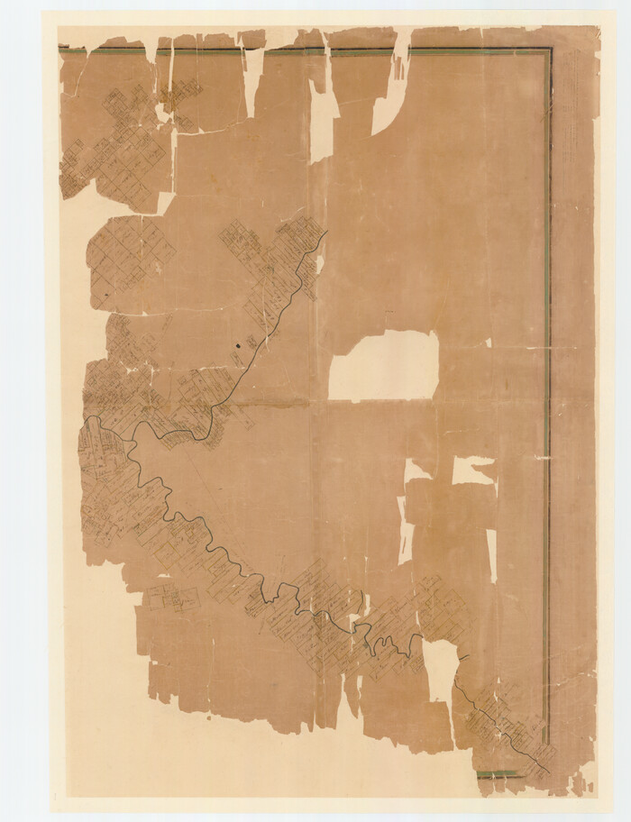
Print $40.00
- Digital $50.00
[Travis District]
1840
Size: 54.7 x 42.0 inches
88739
[Travis District]
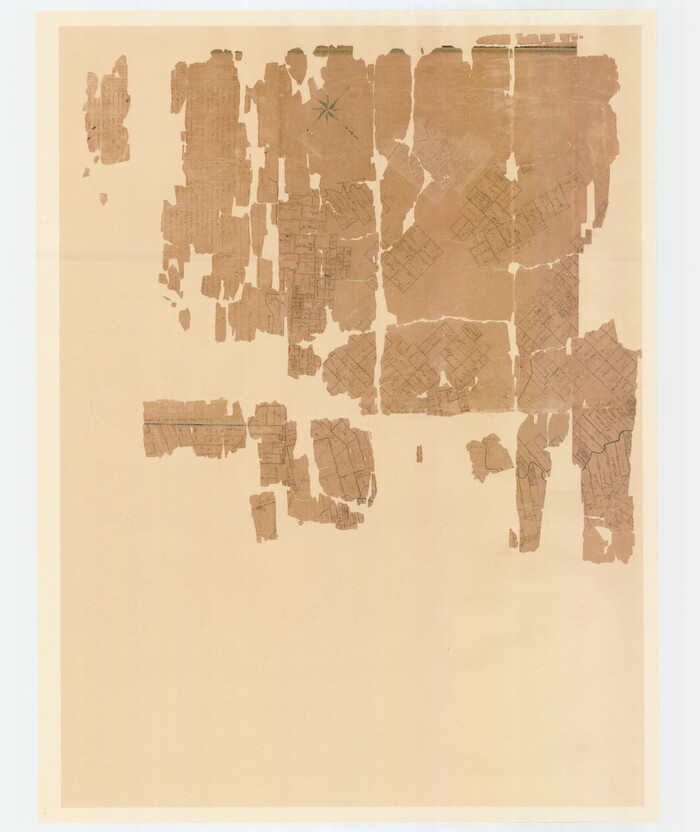
Print $40.00
- Digital $50.00
[Travis District]
1840
Size: 54.7 x 46.0 inches
88740
[Surveys in the Milam District Near the Upper San Gabriel River]
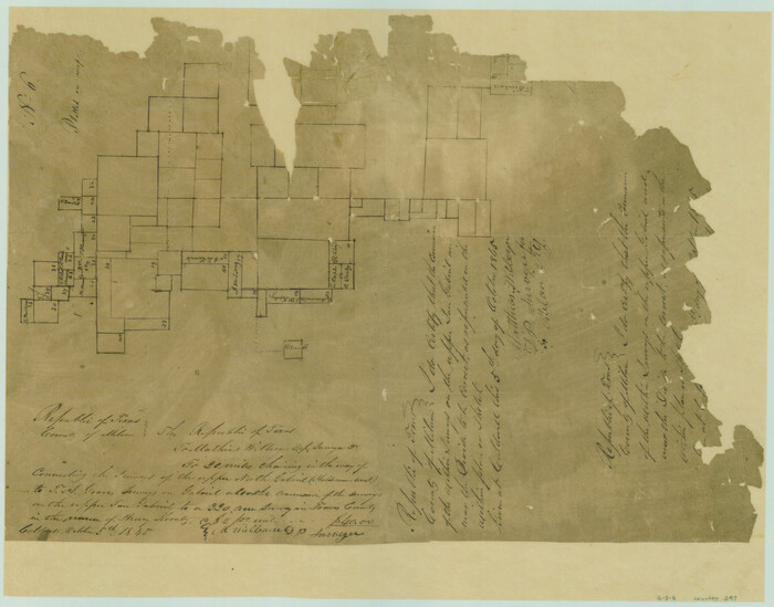
Print $20.00
- Digital $50.00
[Surveys in the Milam District Near the Upper San Gabriel River]
1845
Size: 12.3 x 15.7 inches
247
[Surveying sketch of M.K. McDermott, T. C. R.R. Co., I. & G. N. Ry. Co., et al in Williamson County]
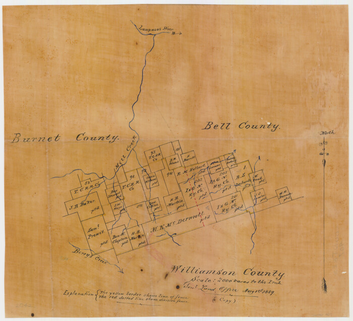
Print $3.00
- Digital $50.00
[Surveying sketch of M.K. McDermott, T. C. R.R. Co., I. & G. N. Ry. Co., et al in Williamson County]
1889
Size: 11.5 x 12.6 inches
407
[Sketch from Burnet Co. to Baylor Co. tying center of counties to county site]
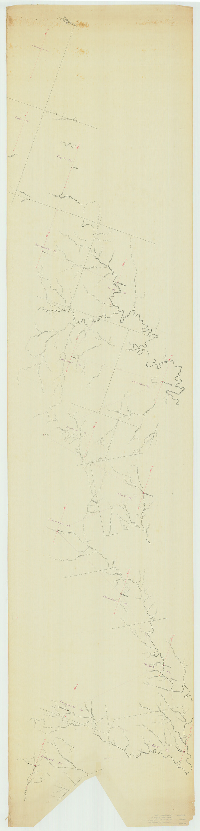
Print $40.00
- Digital $50.00
[Sketch from Burnet Co. to Baylor Co. tying center of counties to county site]
1900
Size: 132.6 x 31.9 inches
1699
[Map of Burnet County]
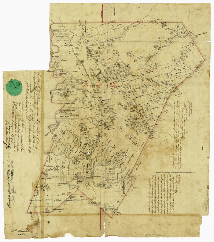
Print $20.00
- Digital $50.00
[Map of Burnet County]
1856
Size: 26.3 x 23.1 inches
4512
Williamson County Sketch File 9

Print $20.00
- Digital $50.00
Williamson County Sketch File 9
1850
Size: 17.4 x 21.6 inches
12692
Williamson County Sketch File 16a

Print $4.00
- Digital $50.00
Williamson County Sketch File 16a
1870
Size: 7.0 x 8.4 inches
40336
Williamson County Rolled Sketch 10

Print $20.00
- Digital $50.00
Williamson County Rolled Sketch 10
1975
Size: 24.8 x 19.2 inches
8267
Water-Shed of the Colorado River

Print $40.00
- Digital $50.00
Water-Shed of the Colorado River
1925
Size: 37.1 x 79.8 inches
65261
Travis County Working Sketch 35

Print $20.00
- Digital $50.00
Travis County Working Sketch 35
1966
Size: 30.4 x 35.5 inches
69419
Travis County State Real Property Sketch 13

Print $26.00
- Digital $50.00
Travis County State Real Property Sketch 13
2006
Size: 35.3 x 24.1 inches
88620
Travis County State Real Property Sketch 12

Print $40.00
- Digital $50.00
Travis County State Real Property Sketch 12
2005
Size: 24.0 x 35.6 inches
88617
Travis County Sketch File 55

Print $20.00
- Digital $50.00
Travis County Sketch File 55
1945
Size: 27.3 x 14.5 inches
12471
Road Guide of Central Texas, Colorado River, Highland Lakes and Hill Country

Print $20.00
- Digital $50.00
Road Guide of Central Texas, Colorado River, Highland Lakes and Hill Country
1947
Size: 18.0 x 21.7 inches
60293
Marble Falls City, Burnet County, Texas

Print $20.00
- Digital $50.00
Marble Falls City, Burnet County, Texas
1890
Size: 26.6 x 20.5 inches
4830

Map of San Gabriel & Lampassas [sic] Surveys
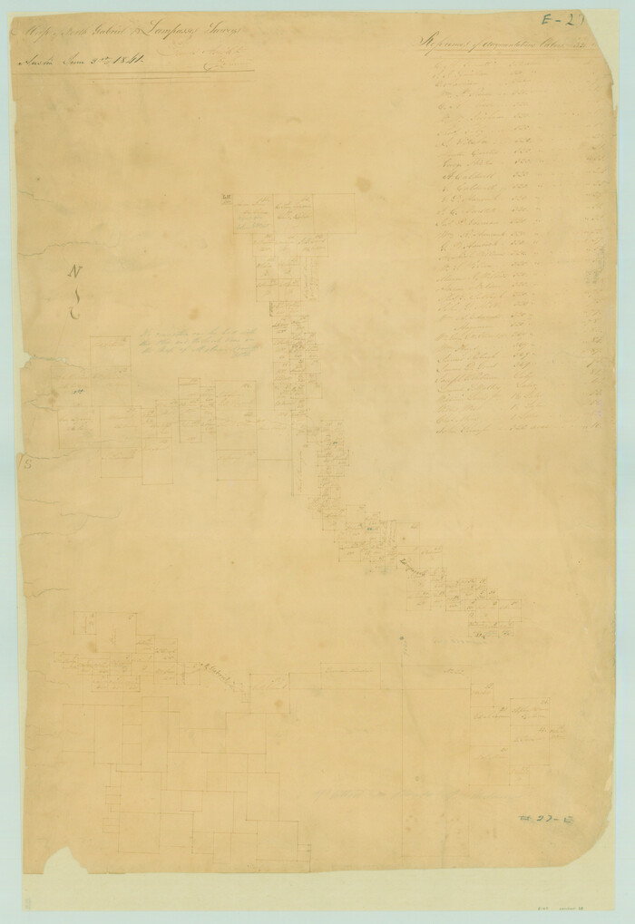
Print $20.00
- Digital $50.00
Map of San Gabriel & Lampassas [sic] Surveys
1841
Size: 29.0 x 20.0 inches
58
Map of Burnet County

Print $20.00
- Digital $50.00
Map of Burnet County
1876
Size: 24.5 x 21.3 inches
3352
Map of Burnet County

Print $20.00
- Digital $50.00
Map of Burnet County
1862
Size: 27.1 x 22.5 inches
3353
Map of Burnet Co.

Print $20.00
- Digital $50.00
Map of Burnet Co.
1887
Size: 45.5 x 37.9 inches
7816
Lampasas County Sketch File A1

Print $2.00
- Digital $50.00
Lampasas County Sketch File A1
Size: 6.8 x 6.3 inches
29385
Lampasas County Sketch File 4

Print $4.00
- Digital $50.00
Lampasas County Sketch File 4
1861
Size: 12.3 x 8.2 inches
29394
Lake Buchanan, Burnet and Llano Counties, Texas

Print $20.00
- Digital $50.00
Lake Buchanan, Burnet and Llano Counties, Texas
1935
Size: 20.7 x 14.4 inches
3136
Highland Lakes of Central Texas

Print $20.00
- Digital $50.00
Highland Lakes of Central Texas
1947
Size: 18.2 x 21.9 inches
60291
General Highway Map, Burnet County, Texas

Print $20.00
General Highway Map, Burnet County, Texas
1940
Size: 18.6 x 25.2 inches
79033
General Highway Map, Burnet County, Texas

Print $20.00
General Highway Map, Burnet County, Texas
1940
Size: 18.4 x 25.0 inches
79035
General Highway Map, Burnet County, Texas

Print $20.00
General Highway Map, Burnet County, Texas
1961
Size: 18.0 x 24.6 inches
79392
[Travis District]
Print $40.00
- Digital $50.00
[Travis District]
1840
-
Size
54.7 x 42.0 inches
-
Map/Doc
88739
-
Creation Date
1840
[Travis District]
Print $40.00
- Digital $50.00
[Travis District]
1840
-
Size
54.7 x 46.0 inches
-
Map/Doc
88740
-
Creation Date
1840
[Surveys in the Milam District Near the Upper San Gabriel River]
Print $20.00
- Digital $50.00
[Surveys in the Milam District Near the Upper San Gabriel River]
1845
-
Size
12.3 x 15.7 inches
-
Map/Doc
247
-
Creation Date
1845
[Surveying sketch of M.K. McDermott, T. C. R.R. Co., I. & G. N. Ry. Co., et al in Williamson County]
Print $3.00
- Digital $50.00
[Surveying sketch of M.K. McDermott, T. C. R.R. Co., I. & G. N. Ry. Co., et al in Williamson County]
1889
-
Size
11.5 x 12.6 inches
-
Map/Doc
407
-
Creation Date
1889
[Sketch from Burnet Co. to Baylor Co. tying center of counties to county site]
Print $40.00
- Digital $50.00
[Sketch from Burnet Co. to Baylor Co. tying center of counties to county site]
1900
-
Size
132.6 x 31.9 inches
-
Map/Doc
1699
-
Creation Date
1900
[Map of Burnet County]
Print $20.00
- Digital $50.00
[Map of Burnet County]
1856
-
Size
26.3 x 23.1 inches
-
Map/Doc
4512
-
Creation Date
1856
Williamson County Sketch File 9
Print $20.00
- Digital $50.00
Williamson County Sketch File 9
1850
-
Size
17.4 x 21.6 inches
-
Map/Doc
12692
-
Creation Date
1850
Williamson County Sketch File 16a
Print $4.00
- Digital $50.00
Williamson County Sketch File 16a
1870
-
Size
7.0 x 8.4 inches
-
Map/Doc
40336
-
Creation Date
1870
Williamson County Rolled Sketch 10
Print $20.00
- Digital $50.00
Williamson County Rolled Sketch 10
1975
-
Size
24.8 x 19.2 inches
-
Map/Doc
8267
-
Creation Date
1975
Water-Shed of the Colorado River
Print $40.00
- Digital $50.00
Water-Shed of the Colorado River
1925
-
Size
37.1 x 79.8 inches
-
Map/Doc
65261
-
Creation Date
1925
Travis County Working Sketch 35
Print $20.00
- Digital $50.00
Travis County Working Sketch 35
1966
-
Size
30.4 x 35.5 inches
-
Map/Doc
69419
-
Creation Date
1966
Travis County State Real Property Sketch 13
Print $26.00
- Digital $50.00
Travis County State Real Property Sketch 13
2006
-
Size
35.3 x 24.1 inches
-
Map/Doc
88620
-
Creation Date
2006
Travis County State Real Property Sketch 12
Print $40.00
- Digital $50.00
Travis County State Real Property Sketch 12
2005
-
Size
24.0 x 35.6 inches
-
Map/Doc
88617
-
Creation Date
2005
Travis County Sketch File 55
Print $20.00
- Digital $50.00
Travis County Sketch File 55
1945
-
Size
27.3 x 14.5 inches
-
Map/Doc
12471
-
Creation Date
1945
Texas Hill Country Trail Region

Texas Hill Country Trail Region
2017
-
Size
18.2 x 24.3 inches
-
Map/Doc
96871
-
Creation Date
2017
Texas Hill Country Trail Region

Texas Hill Country Trail Region
-
Size
18.1 x 24.2 inches
-
Map/Doc
96872
Road Guide of Central Texas, Colorado River, Highland Lakes and Hill Country
Print $20.00
- Digital $50.00
Road Guide of Central Texas, Colorado River, Highland Lakes and Hill Country
1947
-
Size
18.0 x 21.7 inches
-
Map/Doc
60293
-
Creation Date
1947
Marble Falls City, Burnet County, Texas
Print $20.00
- Digital $50.00
Marble Falls City, Burnet County, Texas
1890
-
Size
26.6 x 20.5 inches
-
Map/Doc
4830
-
Creation Date
1890
Map of San Gabriel & Lampassas [sic] Surveys
Print $20.00
- Digital $50.00
Map of San Gabriel & Lampassas [sic] Surveys
1841
-
Size
29.0 x 20.0 inches
-
Map/Doc
58
-
Creation Date
1841
Map of Burnet County
Print $20.00
- Digital $50.00
Map of Burnet County
1876
-
Size
24.5 x 21.3 inches
-
Map/Doc
3352
-
Creation Date
1876
Map of Burnet County
Print $20.00
- Digital $50.00
Map of Burnet County
1862
-
Size
27.1 x 22.5 inches
-
Map/Doc
3353
-
Creation Date
1862
Map of Burnet Co.
Print $20.00
- Digital $50.00
Map of Burnet Co.
1887
-
Size
45.5 x 37.9 inches
-
Map/Doc
7816
-
Creation Date
1887
Lampasas County Sketch File A1
Print $2.00
- Digital $50.00
Lampasas County Sketch File A1
-
Size
6.8 x 6.3 inches
-
Map/Doc
29385
Lampasas County Sketch File 4
Print $4.00
- Digital $50.00
Lampasas County Sketch File 4
1861
-
Size
12.3 x 8.2 inches
-
Map/Doc
29394
-
Creation Date
1861
Lake Buchanan, Burnet and Llano Counties, Texas
Print $20.00
- Digital $50.00
Lake Buchanan, Burnet and Llano Counties, Texas
1935
-
Size
20.7 x 14.4 inches
-
Map/Doc
3136
-
Creation Date
1935
Highland Lakes of Central Texas
Print $20.00
- Digital $50.00
Highland Lakes of Central Texas
1947
-
Size
18.2 x 21.9 inches
-
Map/Doc
60291
-
Creation Date
1947
General Highway Map, Burnet County, Texas
Print $20.00
General Highway Map, Burnet County, Texas
1940
-
Size
18.6 x 25.2 inches
-
Map/Doc
79033
-
Creation Date
1940
General Highway Map, Burnet County, Texas
Print $20.00
General Highway Map, Burnet County, Texas
1940
-
Size
18.4 x 25.0 inches
-
Map/Doc
79035
-
Creation Date
1940
General Highway Map, Burnet County, Texas
Print $20.00
General Highway Map, Burnet County, Texas
1961
-
Size
18.0 x 24.6 inches
-
Map/Doc
79392
-
Creation Date
1961