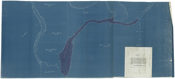
[Surveys on Galveston and East Bay]
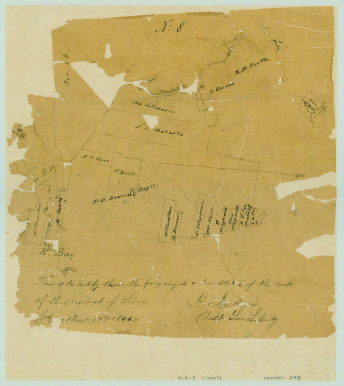
Print $2.00
- Digital $50.00
[Surveys on Galveston and East Bay]
1846
Size: 8.8 x 7.9 inches
248
[Surveys in Vehlein's Colony along the San Jacinto River and Cedar Bayou]
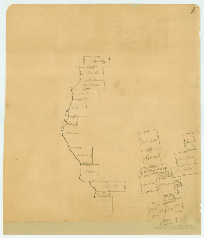
Print $20.00
- Digital $50.00
[Surveys in Vehlein's Colony along the San Jacinto River and Cedar Bayou]
1837
Size: 17.5 x 15.1 inches
75
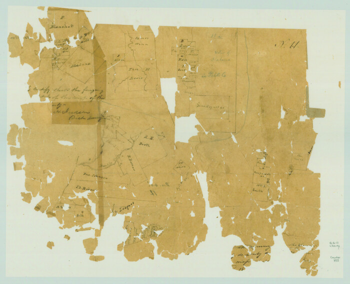
[Surveys in Polk and Chambers Counties]
Print $3.00
- Digital $50.00
[Surveys in Polk and Chambers Counties]
Size: 11.7 x 14.4 inches
355
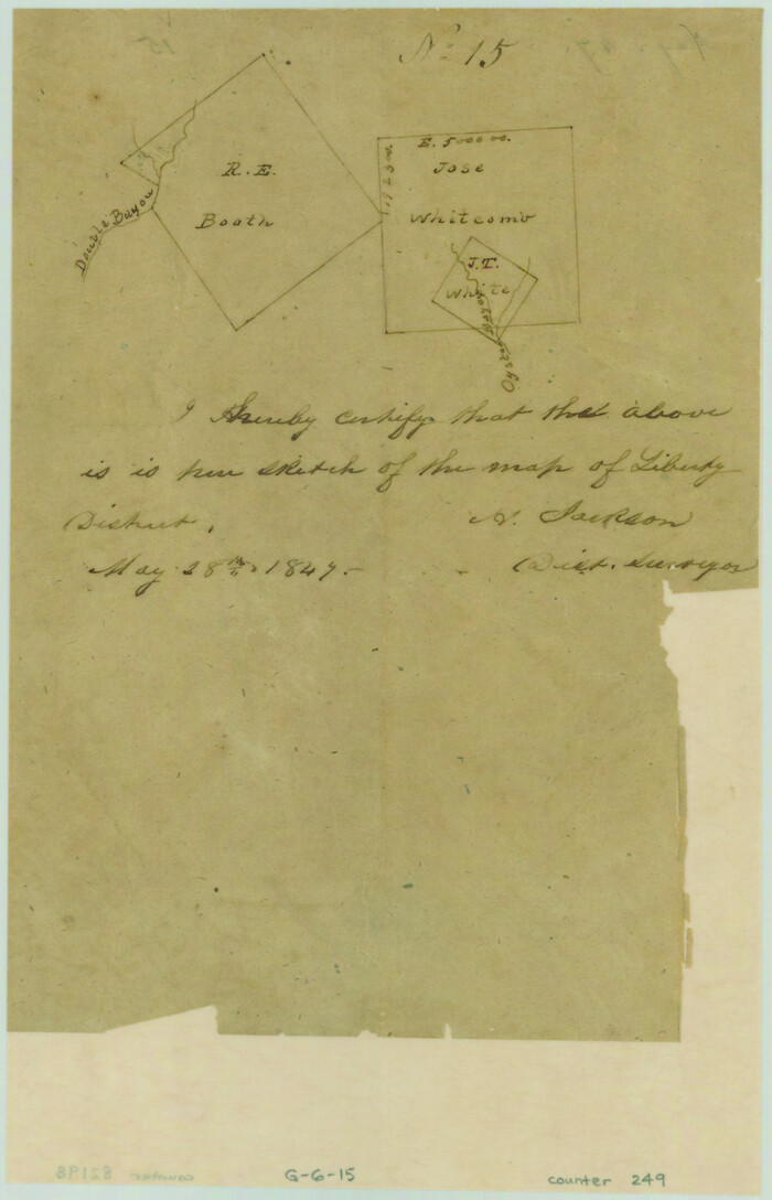
[Surveys in Chambers County]
Print $2.00
- Digital $50.00
[Surveys in Chambers County]
1847
Size: 7.8 x 5.0 inches
249
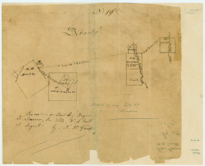
[Surveys in Chambers County, along East Bay Bayou and Elm Bayou]
Print $2.00
- Digital $50.00
[Surveys in Chambers County, along East Bay Bayou and Elm Bayou]
1847
Size: 7.5 x 9.3 inches
69752
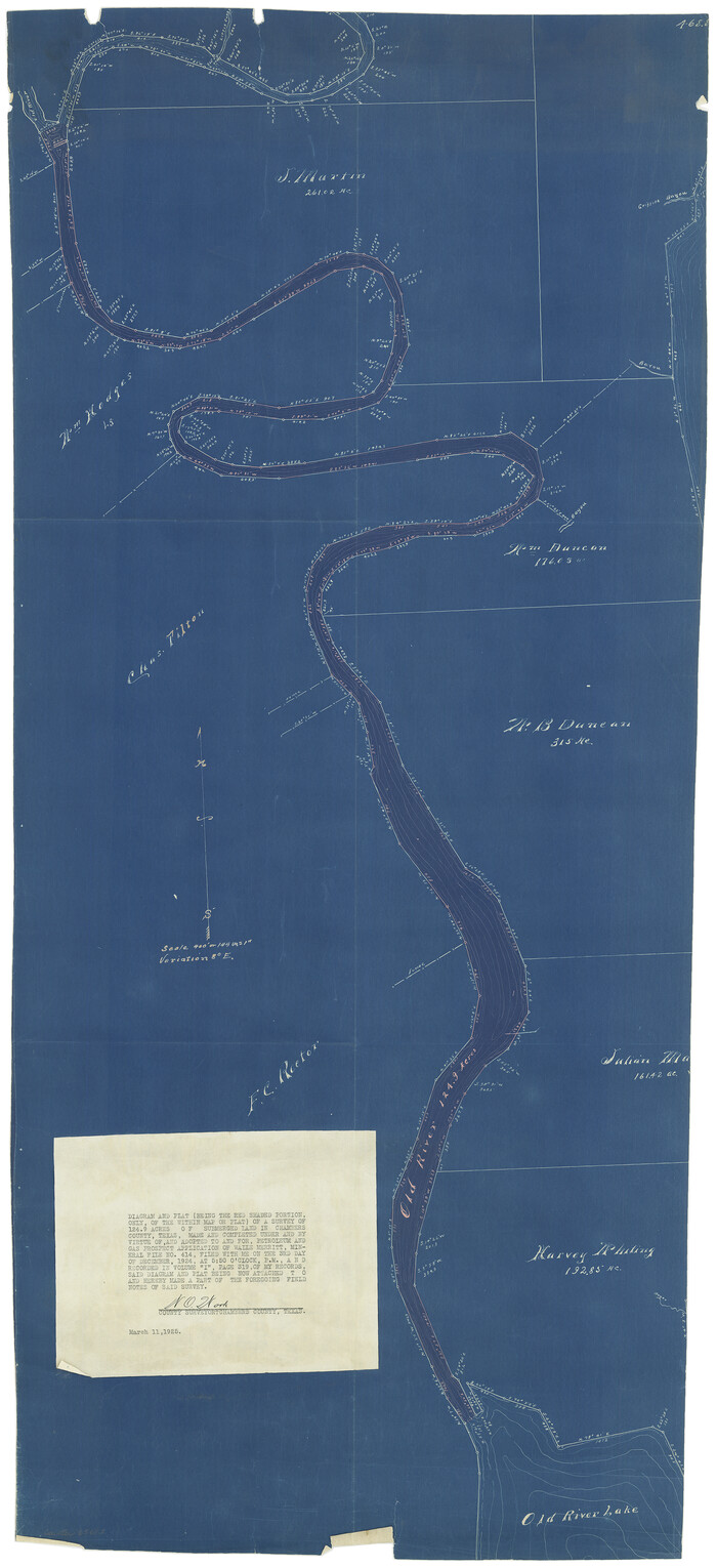
[Sketch for Mineral Application 13440]
Print $20.00
- Digital $50.00
[Sketch for Mineral Application 13440]
1925
Size: 24.3 x 54.0 inches
2799
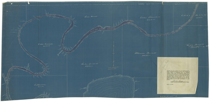
[Sketch for Mineral Application 13439 - Old River, Walle Merritt]
Print $20.00
- Digital $50.00
[Sketch for Mineral Application 13439 - Old River, Walle Merritt]
1925
Size: 41.2 x 18.9 inches
65688
[Sketch for Mineral Application 13439 - Old River, Walle Merritt]
Print $20.00
- Digital $50.00
[Sketch for Mineral Application 13439 - Old River, Walle Merritt]
1925
Size: 41.0 x 19.0 inches
65689
[Sketch for Mineral Application 13436 - Cut-off Bayou]
Print $20.00
- Digital $50.00
[Sketch for Mineral Application 13436 - Cut-off Bayou]
1928
Size: 21.3 x 44.3 inches
65675
[Sketch for Mineral Application 13436 - Cut-off Bayou]
Print $20.00
- Digital $50.00
[Sketch for Mineral Application 13436 - Cut-off Bayou]
1928
Size: 44.1 x 21.6 inches
65676
[Map Showing Surveys in Liberty, Chambers and Harris Counties, Texas]

Print $20.00
- Digital $50.00
[Map Showing Surveys in Liberty, Chambers and Harris Counties, Texas]
1890
Size: 16.1 x 21.1 inches
75768
Upper Galveston Bay, Houston Ship Channel, Dollar Pt. to Atkinson I.

Print $40.00
- Digital $50.00
Upper Galveston Bay, Houston Ship Channel, Dollar Pt. to Atkinson I.
1971
Size: 49.3 x 36.4 inches
69894
Upper Galveston Bay, Houston Ship Channel, Dollar Pt. to Atkinson I.

Print $40.00
- Digital $50.00
Upper Galveston Bay, Houston Ship Channel, Dollar Pt. to Atkinson I.
1972
Size: 49.9 x 36.9 inches
69895
Upper Galveston Bay, Houston Ship Channel, Dollar Pt. to Atkinson I.

Print $40.00
- Digital $50.00
Upper Galveston Bay, Houston Ship Channel, Dollar Pt. to Atkinson I.
1973
Size: 49.8 x 36.8 inches
69896
Upper Galveston Bay, Houston Ship Channel, Dollar Pt. to Atkinson I.

Print $40.00
- Digital $50.00
Upper Galveston Bay, Houston Ship Channel, Dollar Pt. to Atkinson I.
1976
Size: 49.3 x 36.5 inches
69897
Upper Galveston Bay, Houston Ship Channel, Dollar Pt. to Atkinson I.

Print $40.00
- Digital $50.00
Upper Galveston Bay, Houston Ship Channel, Dollar Pt. to Atkinson I.
1978
Size: 49.3 x 36.8 inches
69898
Upper Galveston Bay, Houston Ship Channel, Dollar Pt. to Atkinson I.

Print $40.00
- Digital $50.00
Upper Galveston Bay, Houston Ship Channel, Dollar Pt. to Atkinson I.
1992
Size: 49.2 x 37.0 inches
69899
Texas Gulf Coast from the Sabine River to the Rio Grande Showing Location of Navigation Districts

Print $20.00
- Digital $50.00
Texas Gulf Coast from the Sabine River to the Rio Grande Showing Location of Navigation Districts
1954
Size: 45.0 x 43.8 inches
73596
Texas Gulf Coast Map from the Sabine River to the Rio Grande as subdivided for mineral development

Print $20.00
- Digital $50.00
Texas Gulf Coast Map from the Sabine River to the Rio Grande as subdivided for mineral development
1966
Size: 29.1 x 41.7 inches
2496
Sabine Bank to East Bay including Heald Bank

Print $20.00
- Digital $50.00
Sabine Bank to East Bay including Heald Bank
1925
Size: 44.2 x 34.8 inches
69844
Sabine Bank to East Bay including Heald Bank

Print $20.00
- Digital $50.00
Sabine Bank to East Bay including Heald Bank
1946
Size: 44.8 x 33.9 inches
69845
Sabine Bank to East Bay including Heald Bank

Print $20.00
- Digital $50.00
Sabine Bank to East Bay including Heald Bank
1957
Size: 45.0 x 34.4 inches
69846
Sabine Bank to East Bay including Heald Bank

Print $20.00
- Digital $50.00
Sabine Bank to East Bay including Heald Bank
1960
Size: 45.1 x 34.3 inches
69847
Sabine Bank to East Bay including Heald Bank

Print $20.00
- Digital $50.00
Sabine Bank to East Bay including Heald Bank
1967
Size: 45.1 x 34.3 inches
69848
Sabine Bank to East Bay including Heald Bank

Print $20.00
- Digital $50.00
Sabine Bank to East Bay including Heald Bank
1971
Size: 45.0 x 34.4 inches
69849
Sabine Bank to East Bay including Heald Bank

Print $20.00
- Digital $50.00
Sabine Bank to East Bay including Heald Bank
1973
Size: 44.8 x 34.5 inches
69850
Sabine Bank to East Bay including Heald Bank

Print $20.00
- Digital $50.00
Sabine Bank to East Bay including Heald Bank
1976
Size: 45.0 x 34.5 inches
69851
Sabine Bank to East Bay including Heald Bank

Print $20.00
- Digital $50.00
Sabine Bank to East Bay including Heald Bank
1982
Size: 44.8 x 34.3 inches
69852
[Surveys on Galveston and East Bay]
Print $2.00
- Digital $50.00
[Surveys on Galveston and East Bay]
1846
-
Size
8.8 x 7.9 inches
-
Map/Doc
248
-
Creation Date
1846
[Surveys in Vehlein's Colony along the San Jacinto River and Cedar Bayou]
Print $20.00
- Digital $50.00
[Surveys in Vehlein's Colony along the San Jacinto River and Cedar Bayou]
1837
-
Size
17.5 x 15.1 inches
-
Map/Doc
75
-
Creation Date
1837
[Surveys in Polk and Chambers Counties]
Print $3.00
- Digital $50.00
[Surveys in Polk and Chambers Counties]
-
Size
11.7 x 14.4 inches
-
Map/Doc
355
[Surveys in Chambers County]
Print $2.00
- Digital $50.00
[Surveys in Chambers County]
1847
-
Size
7.8 x 5.0 inches
-
Map/Doc
249
-
Creation Date
1847
[Surveys in Chambers County, along East Bay Bayou and Elm Bayou]
Print $2.00
- Digital $50.00
[Surveys in Chambers County, along East Bay Bayou and Elm Bayou]
1847
-
Size
7.5 x 9.3 inches
-
Map/Doc
69752
-
Creation Date
1847
[Sketch for Mineral Application 13440]
Print $20.00
- Digital $50.00
[Sketch for Mineral Application 13440]
1925
-
Size
24.3 x 54.0 inches
-
Map/Doc
2799
-
Creation Date
1925
[Sketch for Mineral Application 13439 - Old River, Walle Merritt]
Print $20.00
- Digital $50.00
[Sketch for Mineral Application 13439 - Old River, Walle Merritt]
1925
-
Size
41.2 x 18.9 inches
-
Map/Doc
65688
-
Creation Date
1925
[Sketch for Mineral Application 13439 - Old River, Walle Merritt]
Print $20.00
- Digital $50.00
[Sketch for Mineral Application 13439 - Old River, Walle Merritt]
1925
-
Size
41.0 x 19.0 inches
-
Map/Doc
65689
-
Creation Date
1925
[Sketch for Mineral Application 13436 - Cut-off Bayou]
Print $20.00
- Digital $50.00
[Sketch for Mineral Application 13436 - Cut-off Bayou]
1928
-
Size
21.3 x 44.3 inches
-
Map/Doc
65675
-
Creation Date
1928
[Sketch for Mineral Application 13436 - Cut-off Bayou]
Print $20.00
- Digital $50.00
[Sketch for Mineral Application 13436 - Cut-off Bayou]
1928
-
Size
44.1 x 21.6 inches
-
Map/Doc
65676
-
Creation Date
1928
[Map Showing Surveys in Liberty, Chambers and Harris Counties, Texas]
Print $20.00
- Digital $50.00
[Map Showing Surveys in Liberty, Chambers and Harris Counties, Texas]
1890
-
Size
16.1 x 21.1 inches
-
Map/Doc
75768
-
Creation Date
1890
Upper Galveston Bay, Houston Ship Channel, Dollar Pt. to Atkinson I.
Print $40.00
- Digital $50.00
Upper Galveston Bay, Houston Ship Channel, Dollar Pt. to Atkinson I.
1971
-
Size
49.3 x 36.4 inches
-
Map/Doc
69894
-
Creation Date
1971
Upper Galveston Bay, Houston Ship Channel, Dollar Pt. to Atkinson I.
Print $40.00
- Digital $50.00
Upper Galveston Bay, Houston Ship Channel, Dollar Pt. to Atkinson I.
1972
-
Size
49.9 x 36.9 inches
-
Map/Doc
69895
-
Creation Date
1972
Upper Galveston Bay, Houston Ship Channel, Dollar Pt. to Atkinson I.
Print $40.00
- Digital $50.00
Upper Galveston Bay, Houston Ship Channel, Dollar Pt. to Atkinson I.
1973
-
Size
49.8 x 36.8 inches
-
Map/Doc
69896
-
Creation Date
1973
Upper Galveston Bay, Houston Ship Channel, Dollar Pt. to Atkinson I.
Print $40.00
- Digital $50.00
Upper Galveston Bay, Houston Ship Channel, Dollar Pt. to Atkinson I.
1976
-
Size
49.3 x 36.5 inches
-
Map/Doc
69897
-
Creation Date
1976
Upper Galveston Bay, Houston Ship Channel, Dollar Pt. to Atkinson I.
Print $40.00
- Digital $50.00
Upper Galveston Bay, Houston Ship Channel, Dollar Pt. to Atkinson I.
1978
-
Size
49.3 x 36.8 inches
-
Map/Doc
69898
-
Creation Date
1978
Upper Galveston Bay, Houston Ship Channel, Dollar Pt. to Atkinson I.
Print $40.00
- Digital $50.00
Upper Galveston Bay, Houston Ship Channel, Dollar Pt. to Atkinson I.
1992
-
Size
49.2 x 37.0 inches
-
Map/Doc
69899
-
Creation Date
1992
Texas Gulf Coast from the Sabine River to the Rio Grande Showing Location of Navigation Districts
Print $20.00
- Digital $50.00
Texas Gulf Coast from the Sabine River to the Rio Grande Showing Location of Navigation Districts
1954
-
Size
45.0 x 43.8 inches
-
Map/Doc
73596
-
Creation Date
1954
Texas Gulf Coast Map from the Sabine River to the Rio Grande as subdivided for mineral development
Print $20.00
- Digital $50.00
Texas Gulf Coast Map from the Sabine River to the Rio Grande as subdivided for mineral development
1966
-
Size
29.1 x 41.7 inches
-
Map/Doc
2496
-
Creation Date
1966
Sabine Bank to East Bay including Heald Bank
Print $20.00
- Digital $50.00
Sabine Bank to East Bay including Heald Bank
1925
-
Size
44.2 x 34.8 inches
-
Map/Doc
69844
-
Creation Date
1925
Sabine Bank to East Bay including Heald Bank
Print $20.00
- Digital $50.00
Sabine Bank to East Bay including Heald Bank
1946
-
Size
44.8 x 33.9 inches
-
Map/Doc
69845
-
Creation Date
1946
Sabine Bank to East Bay including Heald Bank
Print $20.00
- Digital $50.00
Sabine Bank to East Bay including Heald Bank
1957
-
Size
45.0 x 34.4 inches
-
Map/Doc
69846
-
Creation Date
1957
Sabine Bank to East Bay including Heald Bank
Print $20.00
- Digital $50.00
Sabine Bank to East Bay including Heald Bank
1960
-
Size
45.1 x 34.3 inches
-
Map/Doc
69847
-
Creation Date
1960
Sabine Bank to East Bay including Heald Bank
Print $20.00
- Digital $50.00
Sabine Bank to East Bay including Heald Bank
1967
-
Size
45.1 x 34.3 inches
-
Map/Doc
69848
-
Creation Date
1967
Sabine Bank to East Bay including Heald Bank
Print $20.00
- Digital $50.00
Sabine Bank to East Bay including Heald Bank
1971
-
Size
45.0 x 34.4 inches
-
Map/Doc
69849
-
Creation Date
1971
Sabine Bank to East Bay including Heald Bank
Print $20.00
- Digital $50.00
Sabine Bank to East Bay including Heald Bank
1973
-
Size
44.8 x 34.5 inches
-
Map/Doc
69850
-
Creation Date
1973
Sabine Bank to East Bay including Heald Bank
Print $20.00
- Digital $50.00
Sabine Bank to East Bay including Heald Bank
1976
-
Size
45.0 x 34.5 inches
-
Map/Doc
69851
-
Creation Date
1976
Sabine Bank to East Bay including Heald Bank
Print $20.00
- Digital $50.00
Sabine Bank to East Bay including Heald Bank
1982
-
Size
44.8 x 34.3 inches
-
Map/Doc
69852
-
Creation Date
1982
Sabine Bank

Print $40.00
- Digital $50.00
Sabine Bank
1990
-
Size
35.7 x 48.6 inches
-
Map/Doc
69853
-
Creation Date
1990
Sabine Bank

Print $40.00
- Digital $50.00
Sabine Bank
1992
-
Size
34.1 x 48.4 inches
-
Map/Doc
69854
-
Creation Date
1992