[Miller Day Ranch]
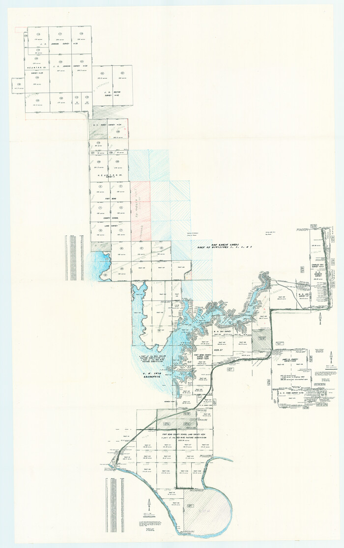
Print $40.00
- Digital $50.00
[Miller Day Ranch]
1995
Size: 60.6 x 38.0 inches
81517
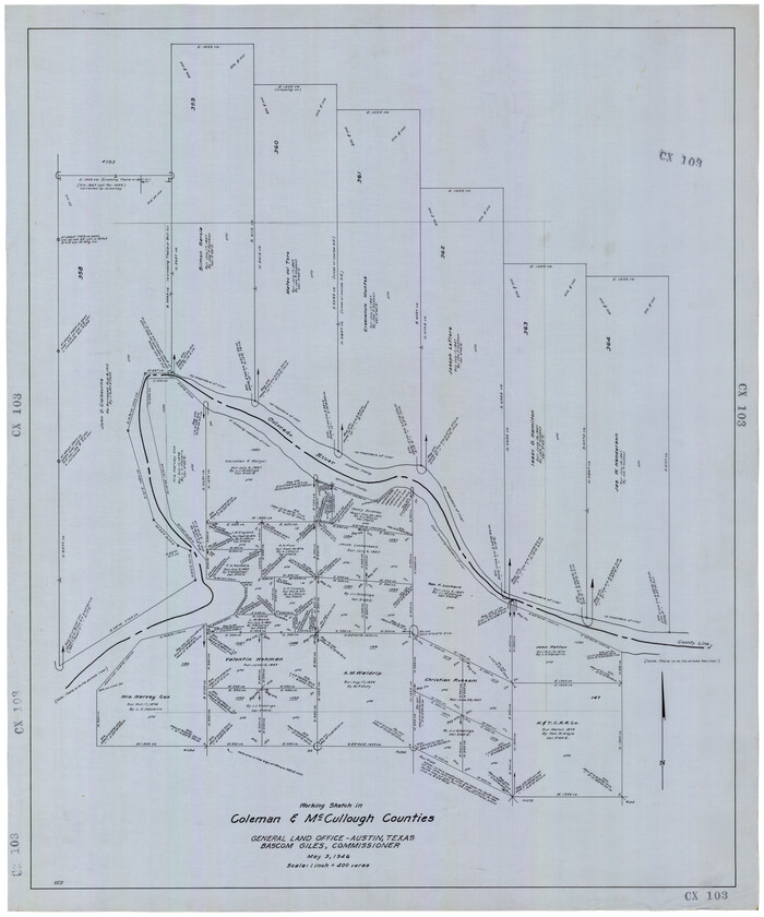
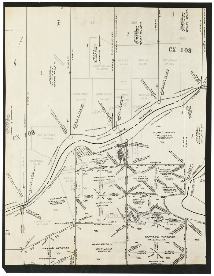
Coleman County Working Sketch 24

Print $40.00
- Digital $50.00
Coleman County Working Sketch 24
1989
Size: 43.1 x 54.3 inches
68277
Runnels County Working Sketch 36

Print $20.00
- Digital $50.00
Runnels County Working Sketch 36
1984
Size: 31.9 x 39.2 inches
63635
General Highway Map, Coleman County, Texas

Print $20.00
General Highway Map, Coleman County, Texas
1961
Size: 24.6 x 18.3 inches
79412
Coleman County Working Sketch 23

Print $20.00
- Digital $50.00
Coleman County Working Sketch 23
1958
Size: 30.4 x 29.5 inches
68276
Coleman County Working Sketch 20

Print $20.00
- Digital $50.00
Coleman County Working Sketch 20
1953
Size: 32.7 x 41.9 inches
68086
Coleman County Working Sketch 19

Print $20.00
- Digital $50.00
Coleman County Working Sketch 19
1953
Size: 18.1 x 15.4 inches
68085
Coleman County Working Sketch 21

Print $20.00
- Digital $50.00
Coleman County Working Sketch 21
1953
Size: 34.8 x 41.6 inches
68087
Coleman County Working Sketch 22

Print $20.00
- Digital $50.00
Coleman County Working Sketch 22
1953
Size: 34.6 x 41.0 inches
68088
Coleman County Working Sketch 13

Print $20.00
- Digital $50.00
Coleman County Working Sketch 13
1952
Size: 37.1 x 26.3 inches
68079
Coleman County Working Sketch 14

Print $20.00
- Digital $50.00
Coleman County Working Sketch 14
1952
Size: 27.8 x 21.2 inches
68080
Coleman County Working Sketch 17

Print $20.00
- Digital $50.00
Coleman County Working Sketch 17
1952
Size: 24.8 x 29.2 inches
68083
Coleman County Working Sketch 18

Print $20.00
- Digital $50.00
Coleman County Working Sketch 18
1952
Size: 24.6 x 34.8 inches
68084
Coleman County Working Sketch 15

Print $20.00
- Digital $50.00
Coleman County Working Sketch 15
1952
Size: 24.3 x 18.1 inches
68081
Coleman County Rolled Sketch 8

Print $40.00
- Digital $50.00
Coleman County Rolled Sketch 8
1951
Size: 58.8 x 40.8 inches
8634
Coleman County Working Sketch 12

Print $20.00
- Digital $50.00
Coleman County Working Sketch 12
1951
Size: 25.7 x 26.2 inches
68078
Coleman County Working Sketch 10

Print $20.00
- Digital $50.00
Coleman County Working Sketch 10
1950
Size: 30.1 x 29.1 inches
68076
Coleman County Working Sketch 9

Print $20.00
- Digital $50.00
Coleman County Working Sketch 9
1950
Size: 24.9 x 30.5 inches
68075
Coleman County Working Sketch 16

Print $20.00
- Digital $50.00
Coleman County Working Sketch 16
1950
Size: 41.7 x 35.7 inches
68082
Coleman County Working Sketch 11

Print $20.00
- Digital $50.00
Coleman County Working Sketch 11
1950
Size: 24.2 x 18.2 inches
68077
Runnels County Working Sketch 20

Print $20.00
- Digital $50.00
Runnels County Working Sketch 20
1950
Size: 23.1 x 30.9 inches
63616
Runnels County Sketch File 29

Print $20.00
Runnels County Sketch File 29
1950
Size: 23.8 x 18.0 inches
12261
Day Ranch Lands, Leaday, Texas

Print $20.00
- Digital $50.00
Day Ranch Lands, Leaday, Texas
1948
Size: 30.8 x 23.0 inches
81516
Concho County Working Sketch 7

Print $20.00
- Digital $50.00
Concho County Working Sketch 7
1948
Size: 44.3 x 46.0 inches
68189
Coleman County Working Sketch 8

Print $20.00
- Digital $50.00
Coleman County Working Sketch 8
1946
Size: 39.3 x 33.3 inches
68074
[Coleman County Sections 359, 360, and 361]
Print $20.00
- Digital $50.00
[Coleman County Sections 359, 360, and 361]
1946
Size: 33.4 x 40.0 inches
92612
[Coleman County Sections 359, 360, and 361]
Print $20.00
- Digital $50.00
[Coleman County Sections 359, 360, and 361]
1946
Size: 17.6 x 22.6 inches
92552
[Miller Day Ranch]
Print $40.00
- Digital $50.00
[Miller Day Ranch]
1995
-
Size
60.6 x 38.0 inches
-
Map/Doc
81517
-
Creation Date
1995
Coleman County Working Sketch 24
Print $40.00
- Digital $50.00
Coleman County Working Sketch 24
1989
-
Size
43.1 x 54.3 inches
-
Map/Doc
68277
-
Creation Date
1989
Runnels County Working Sketch 36
Print $20.00
- Digital $50.00
Runnels County Working Sketch 36
1984
-
Size
31.9 x 39.2 inches
-
Map/Doc
63635
-
Creation Date
1984
General Highway Map, Coleman County, Texas
Print $20.00
General Highway Map, Coleman County, Texas
1961
-
Size
24.6 x 18.3 inches
-
Map/Doc
79412
-
Creation Date
1961
Coleman County Working Sketch 23
Print $20.00
- Digital $50.00
Coleman County Working Sketch 23
1958
-
Size
30.4 x 29.5 inches
-
Map/Doc
68276
-
Creation Date
1958
Coleman County Working Sketch 20
Print $20.00
- Digital $50.00
Coleman County Working Sketch 20
1953
-
Size
32.7 x 41.9 inches
-
Map/Doc
68086
-
Creation Date
1953
Coleman County Working Sketch 19
Print $20.00
- Digital $50.00
Coleman County Working Sketch 19
1953
-
Size
18.1 x 15.4 inches
-
Map/Doc
68085
-
Creation Date
1953
Coleman County Working Sketch 21
Print $20.00
- Digital $50.00
Coleman County Working Sketch 21
1953
-
Size
34.8 x 41.6 inches
-
Map/Doc
68087
-
Creation Date
1953
Coleman County Working Sketch 22
Print $20.00
- Digital $50.00
Coleman County Working Sketch 22
1953
-
Size
34.6 x 41.0 inches
-
Map/Doc
68088
-
Creation Date
1953
Coleman County Working Sketch 13
Print $20.00
- Digital $50.00
Coleman County Working Sketch 13
1952
-
Size
37.1 x 26.3 inches
-
Map/Doc
68079
-
Creation Date
1952
Coleman County Working Sketch 14
Print $20.00
- Digital $50.00
Coleman County Working Sketch 14
1952
-
Size
27.8 x 21.2 inches
-
Map/Doc
68080
-
Creation Date
1952
Coleman County Working Sketch 17
Print $20.00
- Digital $50.00
Coleman County Working Sketch 17
1952
-
Size
24.8 x 29.2 inches
-
Map/Doc
68083
-
Creation Date
1952
Coleman County Working Sketch 18
Print $20.00
- Digital $50.00
Coleman County Working Sketch 18
1952
-
Size
24.6 x 34.8 inches
-
Map/Doc
68084
-
Creation Date
1952
Coleman County Working Sketch 15
Print $20.00
- Digital $50.00
Coleman County Working Sketch 15
1952
-
Size
24.3 x 18.1 inches
-
Map/Doc
68081
-
Creation Date
1952
Coleman County Rolled Sketch 8
Print $40.00
- Digital $50.00
Coleman County Rolled Sketch 8
1951
-
Size
58.8 x 40.8 inches
-
Map/Doc
8634
-
Creation Date
1951
Coleman County Working Sketch 12
Print $20.00
- Digital $50.00
Coleman County Working Sketch 12
1951
-
Size
25.7 x 26.2 inches
-
Map/Doc
68078
-
Creation Date
1951
Coleman County Working Sketch 10
Print $20.00
- Digital $50.00
Coleman County Working Sketch 10
1950
-
Size
30.1 x 29.1 inches
-
Map/Doc
68076
-
Creation Date
1950
Coleman County Working Sketch 9
Print $20.00
- Digital $50.00
Coleman County Working Sketch 9
1950
-
Size
24.9 x 30.5 inches
-
Map/Doc
68075
-
Creation Date
1950
Coleman County Working Sketch 16
Print $20.00
- Digital $50.00
Coleman County Working Sketch 16
1950
-
Size
41.7 x 35.7 inches
-
Map/Doc
68082
-
Creation Date
1950
Coleman County Working Sketch 11
Print $20.00
- Digital $50.00
Coleman County Working Sketch 11
1950
-
Size
24.2 x 18.2 inches
-
Map/Doc
68077
-
Creation Date
1950
Runnels County Working Sketch 20
Print $20.00
- Digital $50.00
Runnels County Working Sketch 20
1950
-
Size
23.1 x 30.9 inches
-
Map/Doc
63616
-
Creation Date
1950
Runnels County Sketch File 29
Print $20.00
Runnels County Sketch File 29
1950
-
Size
23.8 x 18.0 inches
-
Map/Doc
12261
-
Creation Date
1950
Coleman County

Print $40.00
Coleman County
1949
-
Size
68.6 x 43.1 inches
-
Map/Doc
81518
-
Creation Date
1949
Day Ranch Lands, Leaday, Texas
Print $20.00
- Digital $50.00
Day Ranch Lands, Leaday, Texas
1948
-
Size
30.8 x 23.0 inches
-
Map/Doc
81516
-
Creation Date
1948
Concho County Working Sketch 7
Print $20.00
- Digital $50.00
Concho County Working Sketch 7
1948
-
Size
44.3 x 46.0 inches
-
Map/Doc
68189
-
Creation Date
1948
Coleman County Working Sketch 8
Print $20.00
- Digital $50.00
Coleman County Working Sketch 8
1946
-
Size
39.3 x 33.3 inches
-
Map/Doc
68074
-
Creation Date
1946
[Coleman County Sections 359, 360, and 361]
Print $20.00
- Digital $50.00
[Coleman County Sections 359, 360, and 361]
1946
-
Size
33.4 x 40.0 inches
-
Map/Doc
92612
-
Creation Date
1946
[Coleman County Sections 359, 360, and 361]
Print $20.00
- Digital $50.00
[Coleman County Sections 359, 360, and 361]
1946
-
Size
17.6 x 22.6 inches
-
Map/Doc
92552
-
Creation Date
1946
Coleman County

Print $40.00
- Digital $50.00
Coleman County
1945
-
Size
54.9 x 37.1 inches
-
Map/Doc
1803
-
Creation Date
1945
Coleman County

Print $40.00
- Digital $50.00
Coleman County
1945
-
Size
54.7 x 37.1 inches
-
Map/Doc
73109
-
Creation Date
1945