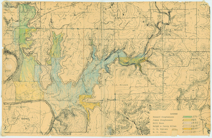
[Topographical Map showing part of Miller Day Ranch in Southwest Part of Coleman County]
Print $3.00
- Digital $50.00
[Topographical Map showing part of Miller Day Ranch in Southwest Part of Coleman County]
Size: 11.3 x 17.3 inches
81515
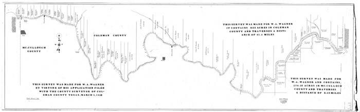
[Sketch for Mineral Application 31137 - Colorado River, W. A. Wagner]
Print $40.00
- Digital $50.00
[Sketch for Mineral Application 31137 - Colorado River, W. A. Wagner]
1928
Size: 39.6 x 126.4 inches
65633
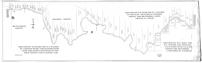
[Sketch for Mineral Application 31137 - Colorado River, W. A. Wagner]
Print $40.00
- Digital $50.00
[Sketch for Mineral Application 31137 - Colorado River, W. A. Wagner]
1928
Size: 39.6 x 126.2 inches
65634
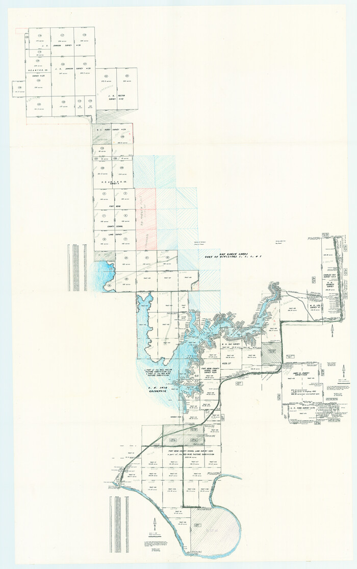
[Miller Day Ranch]
Print $40.00
- Digital $50.00
[Miller Day Ranch]
1995
Size: 60.6 x 38.0 inches
81517
[Coleman and McCullogh County Drilling Block]
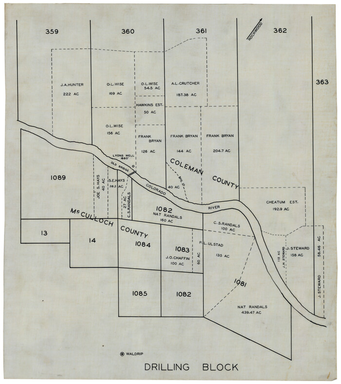
Print $20.00
- Digital $50.00
[Coleman and McCullogh County Drilling Block]
Size: 16.6 x 18.6 inches
92968
[Coleman County Sections 359, 360, and 361]
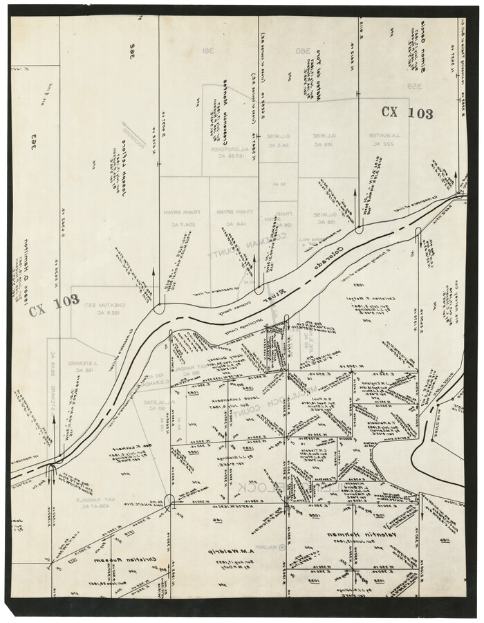
Print $20.00
- Digital $50.00
[Coleman County Sections 359, 360, and 361]
1946
Size: 17.6 x 22.6 inches
92552
[Coleman County Sections 359, 360, and 361]
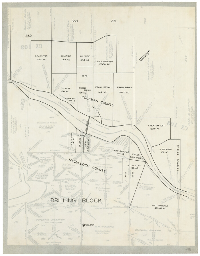
Print $20.00
- Digital $50.00
[Coleman County Sections 359, 360, and 361]
Size: 17.6 x 22.5 inches
92553
[Coleman County Sections 359, 360, and 361]
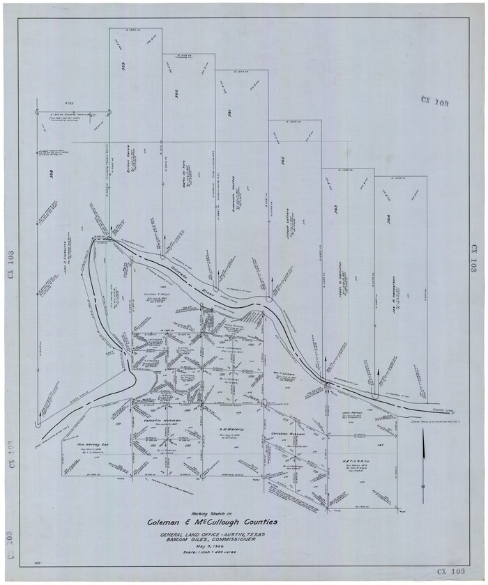
Print $20.00
- Digital $50.00
[Coleman County Sections 359, 360, and 361]
1946
Size: 33.4 x 40.0 inches
92612
Working Sketch in SW cor. of Coleman Co. showing the excess in the surveys fronting on the river and the relative position of surveys north of them according to latest data on file in the Genl. Land Office

Print $20.00
- Digital $50.00
Working Sketch in SW cor. of Coleman Co. showing the excess in the surveys fronting on the river and the relative position of surveys north of them according to latest data on file in the Genl. Land Office
1892
Size: 18.8 x 14.1 inches
441
Water-Shed of the Colorado River

Print $40.00
- Digital $50.00
Water-Shed of the Colorado River
1925
Size: 37.1 x 79.8 inches
65261
Taylor County Sketch File 14

Print $6.00
- Digital $50.00
Taylor County Sketch File 14
1881
Size: 12.9 x 8.5 inches
37802
Taylor County Sketch File 12

Print $4.00
- Digital $50.00
Taylor County Sketch File 12
Size: 8.6 x 12.8 inches
37796
Runnels County Working Sketch 36

Print $20.00
- Digital $50.00
Runnels County Working Sketch 36
1984
Size: 31.9 x 39.2 inches
63635
Runnels County Working Sketch 20

Print $20.00
- Digital $50.00
Runnels County Working Sketch 20
1950
Size: 23.1 x 30.9 inches
63616
Runnels County Sketch File 40

Print $20.00
Runnels County Sketch File 40
1891
Size: 37.7 x 14.3 inches
10594
Runnels County Sketch File 4

Print $6.00
Runnels County Sketch File 4
1871
Size: 12.9 x 8.1 inches
35434
Runnels County Sketch File 39

Print $20.00
Runnels County Sketch File 39
1891
Size: 25.2 x 19.1 inches
12270
Runnels County Sketch File 29

Print $20.00
Runnels County Sketch File 29
1950
Size: 23.8 x 18.0 inches
12261
Runnels County Sketch File 24

Print $20.00
Runnels County Sketch File 24
1930
Size: 25.2 x 21.3 inches
12258
Runnels County Sketch File 15

Print $42.00
Runnels County Sketch File 15
1883
Size: 9.2 x 7.9 inches
35459
Plat of Division 3 of Day Ranch Lands, Leaday, Texas

Print $20.00
- Digital $50.00
Plat of Division 3 of Day Ranch Lands, Leaday, Texas
Size: 20.4 x 21.8 inches
81514
Pecan Bayou Travis District

Print $20.00
- Digital $50.00
Pecan Bayou Travis District
1852
Size: 25.8 x 20.5 inches
4518
Map of [Coleman County]
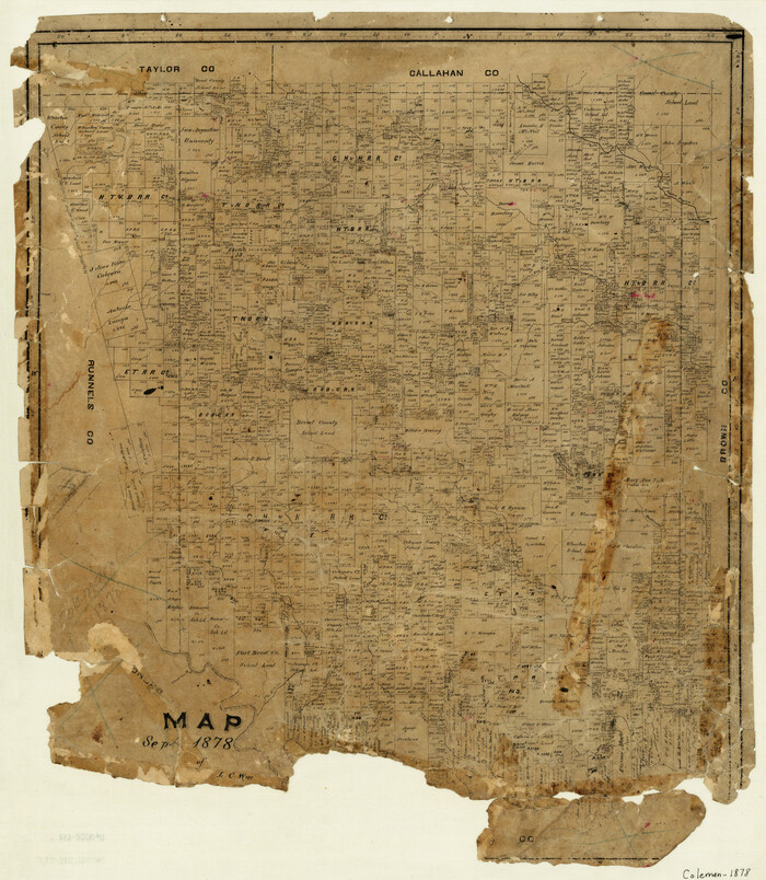
Print $20.00
- Digital $50.00
Map of [Coleman County]
1878
Size: 24.9 x 21.9 inches
3413
Map of Voss, Texas, Coleman County

Print $20.00
- Digital $50.00
Map of Voss, Texas, Coleman County
Size: 15.8 x 16.0 inches
81519
Map of Coleman County, Texas

Print $40.00
- Digital $50.00
Map of Coleman County, Texas
Size: 41.6 x 62.6 inches
89871
Map of Coleman County

Print $20.00
- Digital $50.00
Map of Coleman County
Size: 26.8 x 19.8 inches
3408
Map of Coleman County

Print $20.00
- Digital $50.00
Map of Coleman County
1878
Size: 23.9 x 20.3 inches
3412
Map of Coleman County

Print $20.00
- Digital $50.00
Map of Coleman County
1895
Size: 26.1 x 18.9 inches
3415
Map of Coleman County

Print $40.00
- Digital $50.00
Map of Coleman County
1897
Size: 49.9 x 34.2 inches
4741
General Highway Map, Coleman County, Texas

Print $20.00
General Highway Map, Coleman County, Texas
1940
Size: 18.4 x 25.2 inches
79050
[Topographical Map showing part of Miller Day Ranch in Southwest Part of Coleman County]
Print $3.00
- Digital $50.00
[Topographical Map showing part of Miller Day Ranch in Southwest Part of Coleman County]
-
Size
11.3 x 17.3 inches
-
Map/Doc
81515
[Sketch for Mineral Application 31137 - Colorado River, W. A. Wagner]
Print $40.00
- Digital $50.00
[Sketch for Mineral Application 31137 - Colorado River, W. A. Wagner]
1928
-
Size
39.6 x 126.4 inches
-
Map/Doc
65633
-
Creation Date
1928
[Sketch for Mineral Application 31137 - Colorado River, W. A. Wagner]
Print $40.00
- Digital $50.00
[Sketch for Mineral Application 31137 - Colorado River, W. A. Wagner]
1928
-
Size
39.6 x 126.2 inches
-
Map/Doc
65634
-
Creation Date
1928
[Miller Day Ranch]
Print $40.00
- Digital $50.00
[Miller Day Ranch]
1995
-
Size
60.6 x 38.0 inches
-
Map/Doc
81517
-
Creation Date
1995
[Coleman and McCullogh County Drilling Block]
Print $20.00
- Digital $50.00
[Coleman and McCullogh County Drilling Block]
-
Size
16.6 x 18.6 inches
-
Map/Doc
92968
[Coleman County Sections 359, 360, and 361]
Print $20.00
- Digital $50.00
[Coleman County Sections 359, 360, and 361]
1946
-
Size
17.6 x 22.6 inches
-
Map/Doc
92552
-
Creation Date
1946
[Coleman County Sections 359, 360, and 361]
Print $20.00
- Digital $50.00
[Coleman County Sections 359, 360, and 361]
-
Size
17.6 x 22.5 inches
-
Map/Doc
92553
[Coleman County Sections 359, 360, and 361]
Print $20.00
- Digital $50.00
[Coleman County Sections 359, 360, and 361]
1946
-
Size
33.4 x 40.0 inches
-
Map/Doc
92612
-
Creation Date
1946
Working Sketch in SW cor. of Coleman Co. showing the excess in the surveys fronting on the river and the relative position of surveys north of them according to latest data on file in the Genl. Land Office
Print $20.00
- Digital $50.00
Working Sketch in SW cor. of Coleman Co. showing the excess in the surveys fronting on the river and the relative position of surveys north of them according to latest data on file in the Genl. Land Office
1892
-
Size
18.8 x 14.1 inches
-
Map/Doc
441
-
Creation Date
1892
Water-Shed of the Colorado River
Print $40.00
- Digital $50.00
Water-Shed of the Colorado River
1925
-
Size
37.1 x 79.8 inches
-
Map/Doc
65261
-
Creation Date
1925
Taylor County Sketch File 14
Print $6.00
- Digital $50.00
Taylor County Sketch File 14
1881
-
Size
12.9 x 8.5 inches
-
Map/Doc
37802
-
Creation Date
1881
Taylor County Sketch File 12
Print $4.00
- Digital $50.00
Taylor County Sketch File 12
-
Size
8.6 x 12.8 inches
-
Map/Doc
37796
Runnels County Working Sketch 36
Print $20.00
- Digital $50.00
Runnels County Working Sketch 36
1984
-
Size
31.9 x 39.2 inches
-
Map/Doc
63635
-
Creation Date
1984
Runnels County Working Sketch 20
Print $20.00
- Digital $50.00
Runnels County Working Sketch 20
1950
-
Size
23.1 x 30.9 inches
-
Map/Doc
63616
-
Creation Date
1950
Runnels County Sketch File 40
Print $20.00
Runnels County Sketch File 40
1891
-
Size
37.7 x 14.3 inches
-
Map/Doc
10594
-
Creation Date
1891
Runnels County Sketch File 4
Print $6.00
Runnels County Sketch File 4
1871
-
Size
12.9 x 8.1 inches
-
Map/Doc
35434
-
Creation Date
1871
Runnels County Sketch File 39
Print $20.00
Runnels County Sketch File 39
1891
-
Size
25.2 x 19.1 inches
-
Map/Doc
12270
-
Creation Date
1891
Runnels County Sketch File 29
Print $20.00
Runnels County Sketch File 29
1950
-
Size
23.8 x 18.0 inches
-
Map/Doc
12261
-
Creation Date
1950
Runnels County Sketch File 24
Print $20.00
Runnels County Sketch File 24
1930
-
Size
25.2 x 21.3 inches
-
Map/Doc
12258
-
Creation Date
1930
Runnels County Sketch File 15
Print $42.00
Runnels County Sketch File 15
1883
-
Size
9.2 x 7.9 inches
-
Map/Doc
35459
-
Creation Date
1883
Plat of Division 3 of Day Ranch Lands, Leaday, Texas
Print $20.00
- Digital $50.00
Plat of Division 3 of Day Ranch Lands, Leaday, Texas
-
Size
20.4 x 21.8 inches
-
Map/Doc
81514
Pecan Bayou Travis District
Print $20.00
- Digital $50.00
Pecan Bayou Travis District
1852
-
Size
25.8 x 20.5 inches
-
Map/Doc
4518
-
Creation Date
1852
Map of [Coleman County]
Print $20.00
- Digital $50.00
Map of [Coleman County]
1878
-
Size
24.9 x 21.9 inches
-
Map/Doc
3413
-
Creation Date
1878
Map of Voss, Texas, Coleman County
Print $20.00
- Digital $50.00
Map of Voss, Texas, Coleman County
-
Size
15.8 x 16.0 inches
-
Map/Doc
81519
Map of Coleman County, Texas
Print $40.00
- Digital $50.00
Map of Coleman County, Texas
-
Size
41.6 x 62.6 inches
-
Map/Doc
89871
Map of Coleman County
Print $20.00
- Digital $50.00
Map of Coleman County
-
Size
26.8 x 19.8 inches
-
Map/Doc
3408
Map of Coleman County
Print $20.00
- Digital $50.00
Map of Coleman County
1878
-
Size
23.9 x 20.3 inches
-
Map/Doc
3412
-
Creation Date
1878
Map of Coleman County
Print $20.00
- Digital $50.00
Map of Coleman County
1895
-
Size
26.1 x 18.9 inches
-
Map/Doc
3415
-
Creation Date
1895
Map of Coleman County
Print $40.00
- Digital $50.00
Map of Coleman County
1897
-
Size
49.9 x 34.2 inches
-
Map/Doc
4741
-
Creation Date
1897
General Highway Map, Coleman County, Texas
Print $20.00
General Highway Map, Coleman County, Texas
1940
-
Size
18.4 x 25.2 inches
-
Map/Doc
79050
-
Creation Date
1940