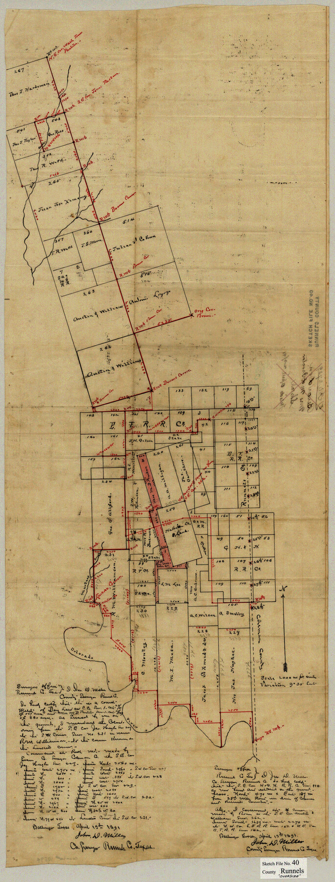
Runnels County Sketch File 40
[Sketch of surveys in the eastern part of Runnels County]
-
Map/Doc
10594
-
Collection
General Map Collection
-
Object Dates
4/13/1891 (Creation Date)
4/22/1891 (File Date)
-
People and Organizations
John D. Miller (Surveyor/Engineer)
-
Counties
Runnels Coleman
-
Subjects
Surveying Sketch File
-
Height x Width
37.7 x 14.3 inches
95.8 x 36.3 cm
-
Medium
paper, manuscript
-
Scale
1" = 2000 varas
-
Features
Mustang Creek
Colorado River
Part of: General Map Collection
Kimble County Working Sketch 27

Print $20.00
- Digital $50.00
Kimble County Working Sketch 27
1934
Size 16.1 x 17.3 inches
Map/Doc 70095

Kerr County Rolled Sketch 24

Print $20.00
- Digital $50.00
Kerr County Rolled Sketch 24
Size 25.1 x 31.4 inches
Map/Doc 6504
Coleman County Working Sketch 6

Print $20.00
- Digital $50.00
Coleman County Working Sketch 6
1939
Size 19.1 x 21.8 inches
Map/Doc 68072
Topographical Map of the Rio Grande, Sheet No. 6

Print $20.00
- Digital $50.00
Topographical Map of the Rio Grande, Sheet No. 6
1912
Map/Doc 89530
Culberson County Sketch File 25

Print $6.00
- Digital $50.00
Culberson County Sketch File 25
Size 11.2 x 8.8 inches
Map/Doc 20259
Township No. 2 South Range No. 24 West of the Indian Meridian

Print $20.00
- Digital $50.00
Township No. 2 South Range No. 24 West of the Indian Meridian
1875
Size 19.3 x 24.4 inches
Map/Doc 75174
Map of Newton Co.

Print $20.00
- Digital $50.00
Map of Newton Co.
1918
Size 46.4 x 39.4 inches
Map/Doc 81987
Harris County Working Sketch 42

Print $20.00
- Digital $50.00
Harris County Working Sketch 42
1940
Size 31.8 x 38.5 inches
Map/Doc 65934
San Patricio County Rolled Sketch 34

Print $20.00
- Digital $50.00
San Patricio County Rolled Sketch 34
Size 25.8 x 26.2 inches
Map/Doc 7584
Presidio County Working Sketch 136

Print $20.00
- Digital $50.00
Presidio County Working Sketch 136
1990
Size 33.7 x 46.8 inches
Map/Doc 71814
Flight Mission No. BQY-14M, Frame 180, Harris County

Print $20.00
- Digital $50.00
Flight Mission No. BQY-14M, Frame 180, Harris County
1953
Size 18.6 x 22.4 inches
Map/Doc 85296
You may also like
Travis County Working Sketch 66

Print $20.00
- Digital $50.00
Travis County Working Sketch 66
2017
Size 24.5 x 36.6 inches
Map/Doc 94122
Crockett County Rolled Sketch 26B

Print $20.00
- Digital $50.00
Crockett County Rolled Sketch 26B
Size 33.1 x 40.1 inches
Map/Doc 8694
General Highway Map, Armstrong County, Texas

Print $20.00
General Highway Map, Armstrong County, Texas
1940
Size 18.1 x 25.0 inches
Map/Doc 79006
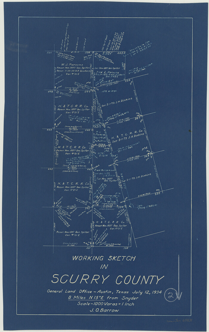
Scurry County Working Sketch 2
Print $3.00
- Digital $50.00
Scurry County Working Sketch 2
1934
Size 16.2 x 10.2 inches
Map/Doc 63831
Hartley County Sketch File 4

Print $6.00
- Digital $50.00
Hartley County Sketch File 4
1883
Size 10.6 x 8.1 inches
Map/Doc 26087
The Judicial District/County of Guadalupe. Created, January 29, 1842

Print $20.00
The Judicial District/County of Guadalupe. Created, January 29, 1842
2020
Size 16.7 x 21.7 inches
Map/Doc 96327
Pecos County Rolled Sketch 117

Print $40.00
- Digital $50.00
Pecos County Rolled Sketch 117
1944
Size 44.6 x 52.6 inches
Map/Doc 9722
Houston County Sketch File 32

Print $4.00
- Digital $50.00
Houston County Sketch File 32
1877
Size 10.8 x 7.1 inches
Map/Doc 26809
Archer County Sketch File 4

Print $4.00
- Digital $50.00
Archer County Sketch File 4
1855
Size 12.2 x 8.2 inches
Map/Doc 13630
Topographical Map of the City of Austin

Print $20.00
- Digital $50.00
Topographical Map of the City of Austin
1887
Size 43.1 x 41.1 inches
Map/Doc 2189
Cass County Working Sketch 28

Print $20.00
- Digital $50.00
Cass County Working Sketch 28
1979
Size 16.0 x 16.8 inches
Map/Doc 67931
Encinal County

Print $20.00
- Digital $50.00
Encinal County
1886
Size 32.2 x 23.6 inches
Map/Doc 3518