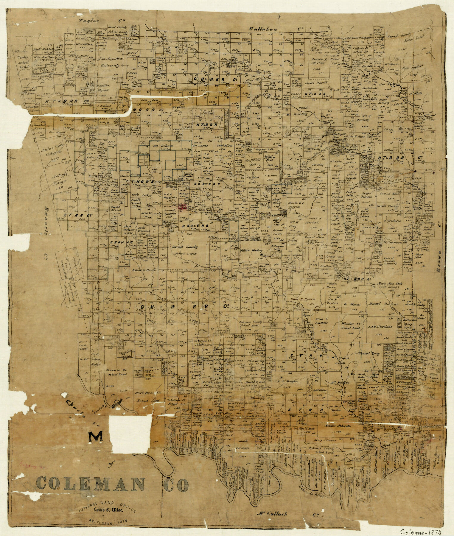
Map of Coleman County
-
Map/Doc
3412
-
Collection
General Map Collection
-
Object Dates
9/1878 (Creation Date)
-
People and Organizations
Louis C. Wise (Draftsman)
-
Counties
Coleman
-
Subjects
County
-
Height x Width
23.9 x 20.3 inches
60.7 x 51.6 cm
-
Features
Coleman City
Colorado River
Camp Creek
Thalia Creek
David's Creek
Concho River
Elm Creek
Urania Creek
Mukewater Creek
Santa Anna's Peak
Bluff Creek
Jim Ned Creek
Hord's Creek
Indian Creek
Cow Creek
Hog Creek
Pecan Bayou
Turtle Bayou
Table Mountain
Rough Creek
Part of: General Map Collection
Hardeman County Sketch File 4

Print $6.00
- Digital $50.00
Hardeman County Sketch File 4
Size 9.3 x 8.2 inches
Map/Doc 24991
Presidio County Rolled Sketch BB

Print $20.00
- Digital $50.00
Presidio County Rolled Sketch BB
1937
Size 26.3 x 27.1 inches
Map/Doc 7407
Flight Mission No. BQR-4K, Frame 67, Brazoria County

Print $20.00
- Digital $50.00
Flight Mission No. BQR-4K, Frame 67, Brazoria County
1952
Size 18.7 x 22.5 inches
Map/Doc 84000
Colorado County Sketch File 23

Print $4.00
- Digital $50.00
Colorado County Sketch File 23
1882
Size 8.8 x 8.3 inches
Map/Doc 18961
Fractional Township No. 7 South Range No. 6 East of the Indian Meridian, Indian Territory

Print $20.00
- Digital $50.00
Fractional Township No. 7 South Range No. 6 East of the Indian Meridian, Indian Territory
1898
Size 19.2 x 24.3 inches
Map/Doc 75211
Sketch of coast of Texas, Laguna Madre from Pt. of Rocks to Corpus Christi [and accompanying letter]
![72962, Sketch of coast of Texas, Laguna Madre from Pt. of Rocks to Corpus Christi [and accompanying letter], General Map Collection](https://historictexasmaps.com/wmedia_w700/maps/72962.tif.jpg)
Print $20.00
- Digital $50.00
Sketch of coast of Texas, Laguna Madre from Pt. of Rocks to Corpus Christi [and accompanying letter]
1881
Size 26.5 x 18.3 inches
Map/Doc 72962
Map showing surveys made on Mustang Island

Print $40.00
- Digital $50.00
Map showing surveys made on Mustang Island
1945
Size 54.7 x 21.0 inches
Map/Doc 2948
Cass County Sketch File 19

Print $40.00
- Digital $50.00
Cass County Sketch File 19
1893
Size 15.7 x 12.6 inches
Map/Doc 17422
Edwards County Working Sketch 114

Print $20.00
- Digital $50.00
Edwards County Working Sketch 114
1972
Size 33.6 x 33.1 inches
Map/Doc 68990
Proceedings of The International (Water) Boundary Commission United States and Mexico Treaties of 1884 and 1889, Volume 2

Proceedings of The International (Water) Boundary Commission United States and Mexico Treaties of 1884 and 1889, Volume 2
Map/Doc 83145
Foard County Working Sketch 2

Print $20.00
- Digital $50.00
Foard County Working Sketch 2
1911
Size 26.3 x 41.4 inches
Map/Doc 69192
Schleicher County Sketch File 44

Print $4.00
- Digital $50.00
Schleicher County Sketch File 44
1950
Size 8.9 x 14.4 inches
Map/Doc 36550
You may also like
Harris County Sketch File 17

Print $4.00
- Digital $50.00
Harris County Sketch File 17
1860
Size 5.8 x 5.6 inches
Map/Doc 25361
![92466, [Muleshoe], Twichell Survey Records](https://historictexasmaps.com/wmedia_w700/maps/92466-1.tif.jpg)
Galveston Bay Texas Lower Part Encluding [sic] Bar and Entrance
![69869, Galveston Bay Texas Lower Part Encluding [sic] Bar and Entrance, General Map Collection](https://historictexasmaps.com/wmedia_w700/maps/69869-1.tif.jpg)
Print $40.00
- Digital $50.00
Galveston Bay Texas Lower Part Encluding [sic] Bar and Entrance
1867
Size 52.6 x 39.1 inches
Map/Doc 69869
[Leagues 622, 621]
![92170, [Leagues 622, 621], Twichell Survey Records](https://historictexasmaps.com/wmedia_w700/maps/92170-1.tif.jpg)
Print $20.00
- Digital $50.00
[Leagues 622, 621]
Size 24.2 x 19.8 inches
Map/Doc 92170

Matagorda County Aerial Photograph Index Sheet 5

Print $20.00
- Digital $50.00
Matagorda County Aerial Photograph Index Sheet 5
1953
Size 23.6 x 19.5 inches
Map/Doc 83726
Collin County Boundary File 3

Print $12.00
- Digital $50.00
Collin County Boundary File 3
Size 10.9 x 7.0 inches
Map/Doc 51685
Cameron County Sketch File 14

Print $38.00
- Digital $50.00
Cameron County Sketch File 14
1993
Size 11.2 x 8.8 inches
Map/Doc 17311
Pecos County Sketch File 96

Print $40.00
- Digital $50.00
Pecos County Sketch File 96
1957
Size 22.4 x 8.7 inches
Map/Doc 33998
Hartley County Rolled Sketch 9

Print $20.00
- Digital $50.00
Hartley County Rolled Sketch 9
2001
Size 22.7 x 34.7 inches
Map/Doc 76407
Gaines County Working Sketch 6

Print $20.00
- Digital $50.00
Gaines County Working Sketch 6
1940
Size 25.0 x 40.8 inches
Map/Doc 69306
General Highway Map, Grayson County, Texas

Print $20.00
General Highway Map, Grayson County, Texas
1940
Size 24.9 x 18.4 inches
Map/Doc 79104