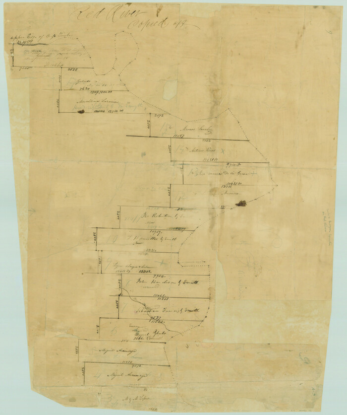
[Surveys along the Red River made for titles under Radford Berry, Commissioner]
Print $20.00
- Digital $50.00
[Surveys along the Red River made for titles under Radford Berry, Commissioner]
Size: 23.3 x 19.5 inches
32
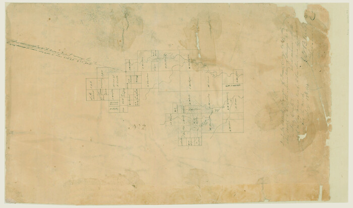
[Surveys along Trinity River]
Print $20.00
- Digital $50.00
[Surveys along Trinity River]
1844
Size: 21.4 x 12.6 inches
7
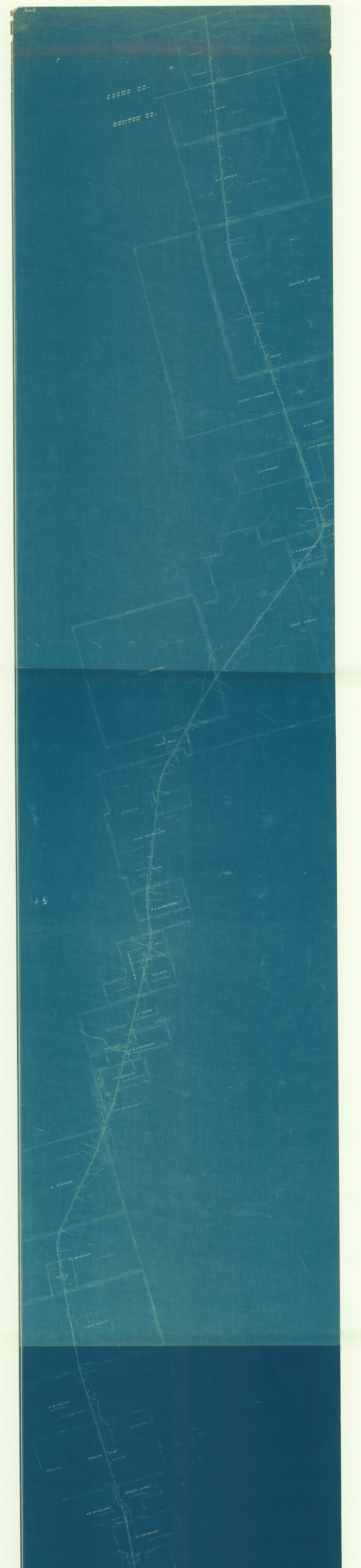
[Map of Located Land of Gulf, Colorado & Santa Fe Ry. Co. through Denton]
Print $40.00
- Digital $50.00
[Map of Located Land of Gulf, Colorado & Santa Fe Ry. Co. through Denton]
Size: 122.8 x 28.3 inches
64340
University and College Lands

Print $20.00
- Digital $50.00
University and College Lands
1841
Size: 21.3 x 27.0 inches
169
University Land in Cooke County

Print $20.00
- Digital $50.00
University Land in Cooke County
1906
Size: 23.6 x 30.0 inches
2425
Trinity River, Watershed

Print $20.00
- Digital $50.00
Trinity River, Watershed
1925
Size: 46.9 x 40.5 inches
65255
Subdivisions of University League 8 in Cooke County

Subdivisions of University League 8 in Cooke County
81728
Nolan County, Texas

Print $20.00
- Digital $50.00
Nolan County, Texas
1880
Size: 29.5 x 22.7 inches
588
Montague County Working Sketch 11

Print $20.00
- Digital $50.00
Montague County Working Sketch 11
1936
Size: 33.8 x 21.3 inches
71077
Montague County Sketch File 9

Print $18.00
- Digital $50.00
Montague County Sketch File 9
1872
Size: 12.6 x 11.7 inches
31724
Montague County Sketch File 8

Print $22.00
- Digital $50.00
Montague County Sketch File 8
Size: 8.1 x 3.7 inches
31722
Montague County Sketch File 6

Print $4.00
- Digital $50.00
Montague County Sketch File 6
1856
Size: 8.0 x 8.4 inches
31717
Montague County Sketch File 2

Print $24.00
- Digital $50.00
Montague County Sketch File 2
1856
Size: 12.0 x 8.5 inches
31711
Montague County Sketch File 16

Print $20.00
- Digital $50.00
Montague County Sketch File 16
1853
Size: 32.5 x 29.2 inches
10546
Montague County Sketch File 12

Print $4.00
- Digital $50.00
Montague County Sketch File 12
Size: 11.4 x 8.2 inches
31736
Montague County Sketch File 1

Print $40.00
- Digital $50.00
Montague County Sketch File 1
1852
Size: 19.4 x 12.4 inches
31709
Map of the Recognised Line, M. El. P. & P. RR. from Texas & Arkansas State Line to Milam & Bexar Land District Line

Print $40.00
- Digital $50.00
Map of the Recognised Line, M. El. P. & P. RR. from Texas & Arkansas State Line to Milam & Bexar Land District Line
Size: 15.3 x 89.4 inches
64638
Map of the Gainesville, Henrietta & Western Railway

Print $20.00
- Digital $50.00
Map of the Gainesville, Henrietta & Western Railway
1887
Size: 9.6 x 41.7 inches
64482
Map of The Surveyed Part of Peters Colony Texas

Print $40.00
- Digital $50.00
Map of The Surveyed Part of Peters Colony Texas
1852
Size: 54.0 x 28.8 inches
3155
Map of Fannin County

Print $20.00
- Digital $50.00
Map of Fannin County
1845
Size: 34.7 x 36.5 inches
16827
Map of Fannin County

Print $20.00
- Digital $50.00
Map of Fannin County
1845
Size: 34.7 x 47.0 inches
87153
Map of Dallas & Wichita Railroad Survey

Print $40.00
- Digital $50.00
Map of Dallas & Wichita Railroad Survey
1874
Size: 37.3 x 82.7 inches
64417
Map of Cooke County originally Fannin Land District

Print $20.00
- Digital $50.00
Map of Cooke County originally Fannin Land District
1858
Size: 25.4 x 18.9 inches
950
Map of Cooke County

Print $20.00
- Digital $50.00
Map of Cooke County
1857
Size: 34.1 x 37.9 inches
1973
Map of Cooke County

Print $20.00
- Digital $50.00
Map of Cooke County
1868
Size: 21.7 x 17.9 inches
3439
Map and Profile of the Denison and Pacific Railway from Denison to Whitesboro

Print $40.00
- Digital $50.00
Map and Profile of the Denison and Pacific Railway from Denison to Whitesboro
1878
Size: 42.5 x 57.5 inches
64284
Map Exhibiting the line of the Southern Trans-Continental R.R. from Marshall to Texarkana from Texarkana to Forth Worth

Print $20.00
- Digital $50.00
Map Exhibiting the line of the Southern Trans-Continental R.R. from Marshall to Texarkana from Texarkana to Forth Worth
1872
Size: 24.6 x 47.8 inches
64241
Lebanon Quadrangle

Print $20.00
- Digital $50.00
Lebanon Quadrangle
1999
Size: 35.4 x 23.4 inches
97360
Grayson County Working Sketch 7

Print $20.00
- Digital $50.00
Grayson County Working Sketch 7
1940
Size: 41.1 x 27.7 inches
63246
Grayson County Working Sketch 21

Print $20.00
- Digital $50.00
Grayson County Working Sketch 21
1961
Size: 42.6 x 26.5 inches
63260
[Surveys along the Red River made for titles under Radford Berry, Commissioner]
Print $20.00
- Digital $50.00
[Surveys along the Red River made for titles under Radford Berry, Commissioner]
-
Size
23.3 x 19.5 inches
-
Map/Doc
32
[Surveys along Trinity River]
Print $20.00
- Digital $50.00
[Surveys along Trinity River]
1844
-
Size
21.4 x 12.6 inches
-
Map/Doc
7
-
Creation Date
1844
[Map of Located Land of Gulf, Colorado & Santa Fe Ry. Co. through Denton]
Print $40.00
- Digital $50.00
[Map of Located Land of Gulf, Colorado & Santa Fe Ry. Co. through Denton]
-
Size
122.8 x 28.3 inches
-
Map/Doc
64340
University and College Lands
Print $20.00
- Digital $50.00
University and College Lands
1841
-
Size
21.3 x 27.0 inches
-
Map/Doc
169
-
Creation Date
1841
University Land in Cooke County
Print $20.00
- Digital $50.00
University Land in Cooke County
1906
-
Size
23.6 x 30.0 inches
-
Map/Doc
2425
-
Creation Date
1906
Trinity River, Watershed
Print $20.00
- Digital $50.00
Trinity River, Watershed
1925
-
Size
46.9 x 40.5 inches
-
Map/Doc
65255
-
Creation Date
1925
Subdivisions of University League 8 in Cooke County
Subdivisions of University League 8 in Cooke County
-
Map/Doc
81728
Nolan County, Texas
Print $20.00
- Digital $50.00
Nolan County, Texas
1880
-
Size
29.5 x 22.7 inches
-
Map/Doc
588
-
Creation Date
1880
Montague County Working Sketch 11
Print $20.00
- Digital $50.00
Montague County Working Sketch 11
1936
-
Size
33.8 x 21.3 inches
-
Map/Doc
71077
-
Creation Date
1936
Montague County Sketch File 9
Print $18.00
- Digital $50.00
Montague County Sketch File 9
1872
-
Size
12.6 x 11.7 inches
-
Map/Doc
31724
-
Creation Date
1872
Montague County Sketch File 8
Print $22.00
- Digital $50.00
Montague County Sketch File 8
-
Size
8.1 x 3.7 inches
-
Map/Doc
31722
Montague County Sketch File 6
Print $4.00
- Digital $50.00
Montague County Sketch File 6
1856
-
Size
8.0 x 8.4 inches
-
Map/Doc
31717
-
Creation Date
1856
Montague County Sketch File 2
Print $24.00
- Digital $50.00
Montague County Sketch File 2
1856
-
Size
12.0 x 8.5 inches
-
Map/Doc
31711
-
Creation Date
1856
Montague County Sketch File 16
Print $20.00
- Digital $50.00
Montague County Sketch File 16
1853
-
Size
32.5 x 29.2 inches
-
Map/Doc
10546
-
Creation Date
1853
Montague County Sketch File 12
Print $4.00
- Digital $50.00
Montague County Sketch File 12
-
Size
11.4 x 8.2 inches
-
Map/Doc
31736
Montague County Sketch File 1
Print $40.00
- Digital $50.00
Montague County Sketch File 1
1852
-
Size
19.4 x 12.4 inches
-
Map/Doc
31709
-
Creation Date
1852
Map of the Recognised Line, M. El. P. & P. RR. from Texas & Arkansas State Line to Milam & Bexar Land District Line
Print $40.00
- Digital $50.00
Map of the Recognised Line, M. El. P. & P. RR. from Texas & Arkansas State Line to Milam & Bexar Land District Line
-
Size
15.3 x 89.4 inches
-
Map/Doc
64638
Map of the Gainesville, Henrietta & Western Railway
Print $20.00
- Digital $50.00
Map of the Gainesville, Henrietta & Western Railway
1887
-
Size
9.6 x 41.7 inches
-
Map/Doc
64482
-
Creation Date
1887
Map of The Surveyed Part of Peters Colony Texas
Print $40.00
- Digital $50.00
Map of The Surveyed Part of Peters Colony Texas
1852
-
Size
54.0 x 28.8 inches
-
Map/Doc
3155
-
Creation Date
1852
Map of Fannin County
Print $20.00
- Digital $50.00
Map of Fannin County
1845
-
Size
34.7 x 36.5 inches
-
Map/Doc
16827
-
Creation Date
1845
Map of Fannin County
Print $20.00
- Digital $50.00
Map of Fannin County
1845
-
Size
34.7 x 47.0 inches
-
Map/Doc
87153
-
Creation Date
1845
Map of Dallas & Wichita Railroad Survey
Print $40.00
- Digital $50.00
Map of Dallas & Wichita Railroad Survey
1874
-
Size
37.3 x 82.7 inches
-
Map/Doc
64417
-
Creation Date
1874
Map of Cooke County originally Fannin Land District
Print $20.00
- Digital $50.00
Map of Cooke County originally Fannin Land District
1858
-
Size
25.4 x 18.9 inches
-
Map/Doc
950
-
Creation Date
1858
Map of Cooke County
Print $20.00
- Digital $50.00
Map of Cooke County
1857
-
Size
34.1 x 37.9 inches
-
Map/Doc
1973
-
Creation Date
1857
Map of Cooke County
Print $20.00
- Digital $50.00
Map of Cooke County
1868
-
Size
21.7 x 17.9 inches
-
Map/Doc
3439
-
Creation Date
1868
Map and Profile of the Denison and Pacific Railway from Denison to Whitesboro
Print $40.00
- Digital $50.00
Map and Profile of the Denison and Pacific Railway from Denison to Whitesboro
1878
-
Size
42.5 x 57.5 inches
-
Map/Doc
64284
-
Creation Date
1878
Map Exhibiting the line of the Southern Trans-Continental R.R. from Marshall to Texarkana from Texarkana to Forth Worth
Print $20.00
- Digital $50.00
Map Exhibiting the line of the Southern Trans-Continental R.R. from Marshall to Texarkana from Texarkana to Forth Worth
1872
-
Size
24.6 x 47.8 inches
-
Map/Doc
64241
-
Creation Date
1872
Lebanon Quadrangle
Print $20.00
- Digital $50.00
Lebanon Quadrangle
1999
USGS Topo Sheet showing plotted Texoma Area Boundary
-
Size
35.4 x 23.4 inches
-
Map/Doc
97360
-
Creation Date
1999
Grayson County Working Sketch 7
Print $20.00
- Digital $50.00
Grayson County Working Sketch 7
1940
-
Size
41.1 x 27.7 inches
-
Map/Doc
63246
-
Creation Date
1940
Grayson County Working Sketch 21
Print $20.00
- Digital $50.00
Grayson County Working Sketch 21
1961
-
Size
42.6 x 26.5 inches
-
Map/Doc
63260
-
Creation Date
1961