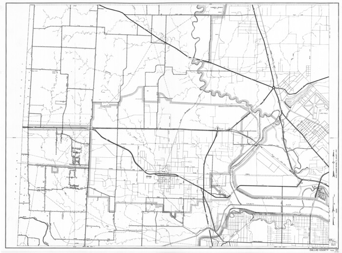
Dallas County Working Sketch 21

Print $20.00
- Digital $50.00
Dallas County Working Sketch 21
2008
Size: 32.6 x 33.9 inches
88761
Denton County Sketch File 43

Print $20.00
- Digital $50.00
Denton County Sketch File 43
2006
Size: 11.0 x 8.5 inches
83610
Dallas/Fort Worth Street Map & Visitor Guide

Dallas/Fort Worth Street Map & Visitor Guide
2000
Size: 35.5 x 23.1 inches
94296
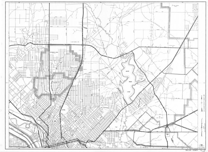
Dallas County Working Sketch 19

Print $20.00
- Digital $50.00
Dallas County Working Sketch 19
1997
Size: 23.1 x 30.3 inches
68585
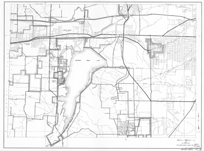
Dallas County Working Sketch 18

Print $20.00
- Digital $50.00
Dallas County Working Sketch 18
1989
Size: 39.9 x 37.4 inches
68584
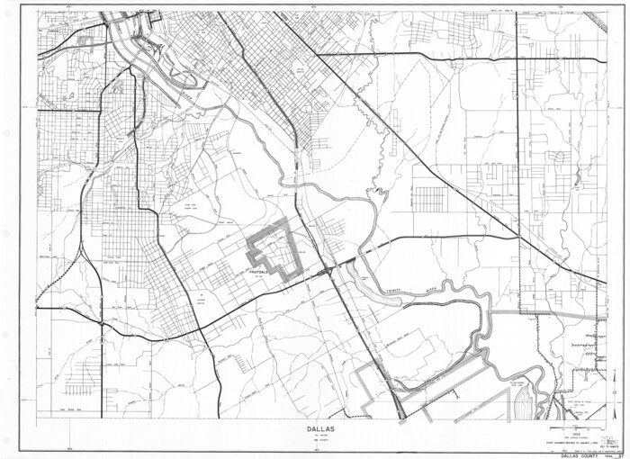
Dallas County Working Sketch 14

Print $20.00
- Digital $50.00
Dallas County Working Sketch 14
1987
Size: 31.2 x 21.7 inches
68580
Dallas County Working Sketch 13

Print $20.00
- Digital $50.00
Dallas County Working Sketch 13
1984
Size: 27.9 x 32.6 inches
68579
Dallas County Rolled Sketch 6

Print $20.00
- Digital $50.00
Dallas County Rolled Sketch 6
1983
Size: 31.7 x 37.5 inches
8769
Dallas County Working Sketch 12

Print $20.00
- Digital $50.00
Dallas County Working Sketch 12
1983
Size: 30.5 x 44.1 inches
68578
Dallas County Working Sketch 11

Print $20.00
- Digital $50.00
Dallas County Working Sketch 11
1982
Size: 32.2 x 23.1 inches
68577
Dallas County Working Sketch 16

Print $20.00
- Digital $50.00
Dallas County Working Sketch 16
1981
Size: 15.7 x 12.0 inches
68582
Dallas County Working Sketch 15

Print $20.00
- Digital $50.00
Dallas County Working Sketch 15
1980
Size: 14.3 x 11.4 inches
68581
Dallas County Working Sketch 10

Print $20.00
- Digital $50.00
Dallas County Working Sketch 10
1971
Size: 22.6 x 22.7 inches
68576
Go Turnpike! Dallas-Fort Worth Turnpike (Recto)

Go Turnpike! Dallas-Fort Worth Turnpike (Recto)
1963
Size: 11.2 x 17.2 inches
94177
Go Turnpike! Dallas-Fort Worth Turnpike (Verso)

Go Turnpike! Dallas-Fort Worth Turnpike (Verso)
1963
Size: 11.2 x 17.2 inches
94178
General Highway Map, Dallas County, Rockwall County, Texas

Print $20.00
General Highway Map, Dallas County, Rockwall County, Texas
1961
Size: 18.4 x 24.5 inches
79430
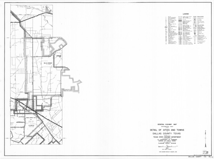
General Highway Map. Detail of Cities and Towns in Dallas County, Texas [Dallas and vicinity]
Print $20.00
General Highway Map. Detail of Cities and Towns in Dallas County, Texas [Dallas and vicinity]
1961
Size: 18.1 x 24.4 inches
79431
General Highway Map. Detail of Cities and Towns in Dallas County, Texas [Dallas and vicinity]
Print $20.00
General Highway Map. Detail of Cities and Towns in Dallas County, Texas [Dallas and vicinity]
1961
Size: 18.1 x 24.7 inches
79432
General Highway Map. Detail of Cities and Towns in Dallas County, Texas [Dallas and vicinity]
Print $20.00
General Highway Map. Detail of Cities and Towns in Dallas County, Texas [Dallas and vicinity]
1961
Size: 18.1 x 24.5 inches
79433
General Highway Map. Detail of Cities and Towns in Dallas County, Texas [Dallas and vicinity]
Print $20.00
General Highway Map. Detail of Cities and Towns in Dallas County, Texas [Dallas and vicinity]
1961
Size: 18.0 x 24.7 inches
79434
General Highway Map. Detail of Cities and Towns in Dallas County, Texas [Dallas and vicinity]
Print $20.00
General Highway Map. Detail of Cities and Towns in Dallas County, Texas [Dallas and vicinity]
1961
Size: 18.2 x 24.6 inches
79435
Dallas County Working Sketch 9

Print $20.00
- Digital $50.00
Dallas County Working Sketch 9
1960
Size: 23.1 x 20.0 inches
68575
Dallas County Rolled Sketch 5

Print $20.00
- Digital $50.00
Dallas County Rolled Sketch 5
1955
Size: 23.8 x 30.8 inches
5689
Dallas County Rolled Sketch 4

Print $20.00
- Digital $50.00
Dallas County Rolled Sketch 4
1954
Size: 13.1 x 24.2 inches
5687
Dallas County Rolled Sketch 4A

Print $20.00
- Digital $50.00
Dallas County Rolled Sketch 4A
1954
Size: 12.5 x 23.1 inches
5688
Dallas County Rolled Sketch 3

Print $40.00
- Digital $50.00
Dallas County Rolled Sketch 3
1953
Size: 30.7 x 78.5 inches
8767
Dallas County Rolled Sketch 3A

Print $40.00
- Digital $50.00
Dallas County Rolled Sketch 3A
1953
Size: 29.9 x 78.8 inches
8768
Dallas County Working Sketch 8

Print $20.00
- Digital $50.00
Dallas County Working Sketch 8
1953
Size: 20.6 x 26.4 inches
68574
Dallas County Working Sketch 7

Print $20.00
- Digital $50.00
Dallas County Working Sketch 7
1952
Size: 17.3 x 23.5 inches
68573
Dallas County Boundary File 9

Print $6.00
- Digital $50.00
Dallas County Boundary File 9
2008
-
Map/Doc
88850
-
Creation Date
2008
Dallas County Working Sketch 21
Print $20.00
- Digital $50.00
Dallas County Working Sketch 21
2008
-
Size
32.6 x 33.9 inches
-
Map/Doc
88761
-
Creation Date
2008
Denton County Sketch File 43
Print $20.00
- Digital $50.00
Denton County Sketch File 43
2006
-
Size
11.0 x 8.5 inches
-
Map/Doc
83610
-
Creation Date
2006
Dallas/Fort Worth Street Map & Visitor Guide
Dallas/Fort Worth Street Map & Visitor Guide
2000
-
Size
35.5 x 23.1 inches
-
Map/Doc
94296
-
Creation Date
2000
Dallas County Working Sketch 19
Print $20.00
- Digital $50.00
Dallas County Working Sketch 19
1997
-
Size
23.1 x 30.3 inches
-
Map/Doc
68585
-
Creation Date
1997
Dallas County Working Sketch 18
Print $20.00
- Digital $50.00
Dallas County Working Sketch 18
1989
-
Size
39.9 x 37.4 inches
-
Map/Doc
68584
-
Creation Date
1989
Dallas County Working Sketch 14
Print $20.00
- Digital $50.00
Dallas County Working Sketch 14
1987
-
Size
31.2 x 21.7 inches
-
Map/Doc
68580
-
Creation Date
1987
Dallas County Working Sketch 13
Print $20.00
- Digital $50.00
Dallas County Working Sketch 13
1984
-
Size
27.9 x 32.6 inches
-
Map/Doc
68579
-
Creation Date
1984
Dallas County Rolled Sketch 6
Print $20.00
- Digital $50.00
Dallas County Rolled Sketch 6
1983
-
Size
31.7 x 37.5 inches
-
Map/Doc
8769
-
Creation Date
1983
Dallas County Working Sketch 12
Print $20.00
- Digital $50.00
Dallas County Working Sketch 12
1983
-
Size
30.5 x 44.1 inches
-
Map/Doc
68578
-
Creation Date
1983
Dallas County Working Sketch 11
Print $20.00
- Digital $50.00
Dallas County Working Sketch 11
1982
-
Size
32.2 x 23.1 inches
-
Map/Doc
68577
-
Creation Date
1982
Dallas County Working Sketch 16
Print $20.00
- Digital $50.00
Dallas County Working Sketch 16
1981
-
Size
15.7 x 12.0 inches
-
Map/Doc
68582
-
Creation Date
1981
Dallas County Working Sketch 15
Print $20.00
- Digital $50.00
Dallas County Working Sketch 15
1980
-
Size
14.3 x 11.4 inches
-
Map/Doc
68581
-
Creation Date
1980
Dallas County Working Sketch 10
Print $20.00
- Digital $50.00
Dallas County Working Sketch 10
1971
-
Size
22.6 x 22.7 inches
-
Map/Doc
68576
-
Creation Date
1971
Go Turnpike! Dallas-Fort Worth Turnpike (Recto)
Go Turnpike! Dallas-Fort Worth Turnpike (Recto)
1963
-
Size
11.2 x 17.2 inches
-
Map/Doc
94177
-
Creation Date
1963
Go Turnpike! Dallas-Fort Worth Turnpike (Verso)
Go Turnpike! Dallas-Fort Worth Turnpike (Verso)
1963
-
Size
11.2 x 17.2 inches
-
Map/Doc
94178
-
Creation Date
1963
General Highway Map, Dallas County, Rockwall County, Texas
Print $20.00
General Highway Map, Dallas County, Rockwall County, Texas
1961
-
Size
18.4 x 24.5 inches
-
Map/Doc
79430
-
Creation Date
1961
General Highway Map. Detail of Cities and Towns in Dallas County, Texas [Dallas and vicinity]
Print $20.00
General Highway Map. Detail of Cities and Towns in Dallas County, Texas [Dallas and vicinity]
1961
-
Size
18.1 x 24.4 inches
-
Map/Doc
79431
-
Creation Date
1961
General Highway Map. Detail of Cities and Towns in Dallas County, Texas [Dallas and vicinity]
Print $20.00
General Highway Map. Detail of Cities and Towns in Dallas County, Texas [Dallas and vicinity]
1961
-
Size
18.1 x 24.7 inches
-
Map/Doc
79432
-
Creation Date
1961
General Highway Map. Detail of Cities and Towns in Dallas County, Texas [Dallas and vicinity]
Print $20.00
General Highway Map. Detail of Cities and Towns in Dallas County, Texas [Dallas and vicinity]
1961
-
Size
18.1 x 24.5 inches
-
Map/Doc
79433
-
Creation Date
1961
General Highway Map. Detail of Cities and Towns in Dallas County, Texas [Dallas and vicinity]
Print $20.00
General Highway Map. Detail of Cities and Towns in Dallas County, Texas [Dallas and vicinity]
1961
-
Size
18.0 x 24.7 inches
-
Map/Doc
79434
-
Creation Date
1961
General Highway Map. Detail of Cities and Towns in Dallas County, Texas [Dallas and vicinity]
Print $20.00
General Highway Map. Detail of Cities and Towns in Dallas County, Texas [Dallas and vicinity]
1961
-
Size
18.2 x 24.6 inches
-
Map/Doc
79435
-
Creation Date
1961
Dallas County Working Sketch 9
Print $20.00
- Digital $50.00
Dallas County Working Sketch 9
1960
-
Size
23.1 x 20.0 inches
-
Map/Doc
68575
-
Creation Date
1960
Dallas County Rolled Sketch 5
Print $20.00
- Digital $50.00
Dallas County Rolled Sketch 5
1955
-
Size
23.8 x 30.8 inches
-
Map/Doc
5689
-
Creation Date
1955
Dallas County Rolled Sketch 4
Print $20.00
- Digital $50.00
Dallas County Rolled Sketch 4
1954
-
Size
13.1 x 24.2 inches
-
Map/Doc
5687
-
Creation Date
1954
Dallas County Rolled Sketch 4A
Print $20.00
- Digital $50.00
Dallas County Rolled Sketch 4A
1954
-
Size
12.5 x 23.1 inches
-
Map/Doc
5688
-
Creation Date
1954
Dallas County Rolled Sketch 3
Print $40.00
- Digital $50.00
Dallas County Rolled Sketch 3
1953
-
Size
30.7 x 78.5 inches
-
Map/Doc
8767
-
Creation Date
1953
Dallas County Rolled Sketch 3A
Print $40.00
- Digital $50.00
Dallas County Rolled Sketch 3A
1953
-
Size
29.9 x 78.8 inches
-
Map/Doc
8768
-
Creation Date
1953
Dallas County Working Sketch 8
Print $20.00
- Digital $50.00
Dallas County Working Sketch 8
1953
-
Size
20.6 x 26.4 inches
-
Map/Doc
68574
-
Creation Date
1953
Dallas County Working Sketch 7
Print $20.00
- Digital $50.00
Dallas County Working Sketch 7
1952
-
Size
17.3 x 23.5 inches
-
Map/Doc
68573
-
Creation Date
1952