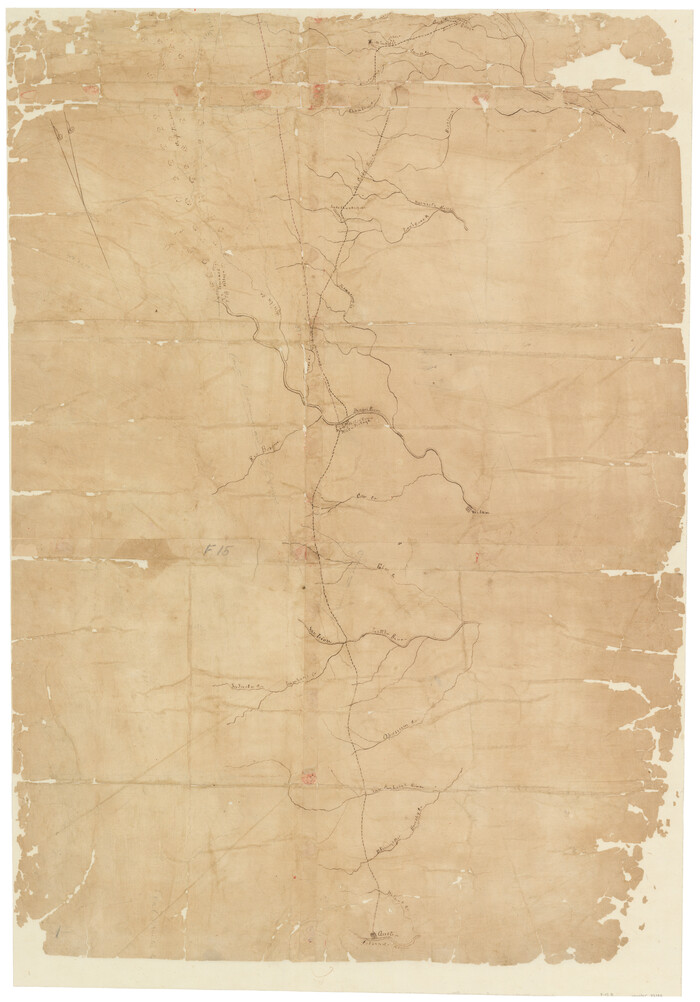
[Unidentified Railroad through Denton and Dallas County]

Print $40.00
- Digital $50.00
[Unidentified Railroad through Denton and Dallas County]
Size: 6.8 x 121.3 inches
64774
[Unidentified Railroad through Denton and Dallas County]

Print $40.00
- Digital $50.00
[Unidentified Railroad through Denton and Dallas County]
Size: 6.8 x 73.3 inches
64775
[Texas & Pacific Railway, Longview to Dallas]
Print $40.00
- Digital $50.00
[Texas & Pacific Railway, Longview to Dallas]
1873
Size: 15.5 x 124.0 inches
64097
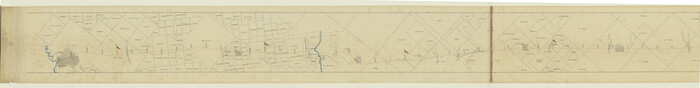
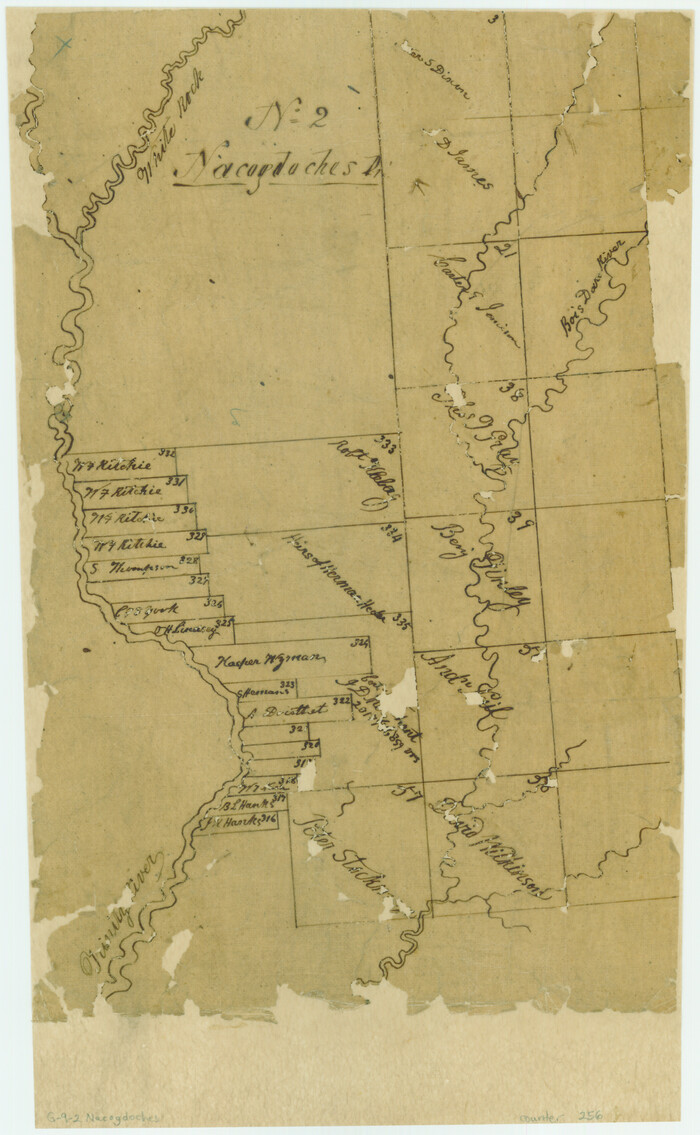
[Surveys along the Trinity River, Bois d'Arc Creek and White Rock Lake]
Print $2.00
- Digital $50.00
[Surveys along the Trinity River, Bois d'Arc Creek and White Rock Lake]
Size: 10.8 x 6.7 inches
256
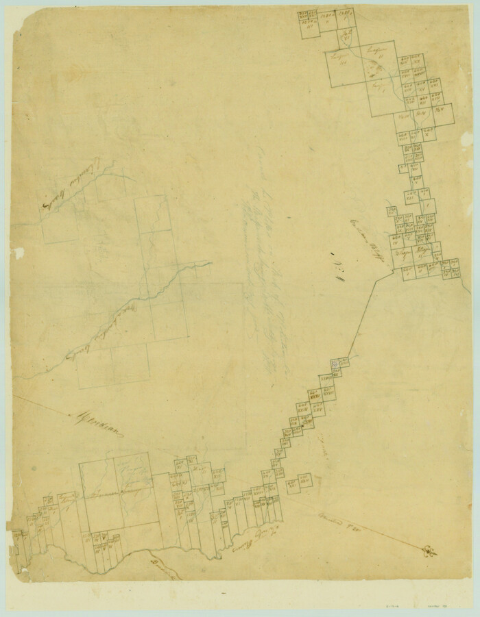
[Surveys along the Trinity River and below]
Print $20.00
- Digital $50.00
[Surveys along the Trinity River and below]
1840
Size: 22.6 x 17.6 inches
101
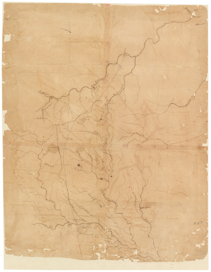
[Sketch of Col. Cooke's Military Road expedition from Red River to Austin]
Print $20.00
- Digital $50.00
[Sketch of Col. Cooke's Military Road expedition from Red River to Austin]
Size: 29.4 x 22.9 inches
166
[Sketch of Col. Cooke's Military Road expedition from Red River to Austin]
Print $20.00
- Digital $50.00
[Sketch of Col. Cooke's Military Road expedition from Red River to Austin]
Size: 33.4 x 23.4 inches
82146
Worley's Map of Greater Dallas

Print $20.00
Worley's Map of Greater Dallas
1905
Size: 34.9 x 25.4 inches
79319
Trinity River, White Rock Reservoir Sheet/White Rock Creek

Print $6.00
- Digital $50.00
Trinity River, White Rock Reservoir Sheet/White Rock Creek
1923
Size: 36.3 x 16.7 inches
65213
Trinity River, White Rock Creek Sheet

Print $6.00
- Digital $50.00
Trinity River, White Rock Creek Sheet
1923
Size: 33.0 x 24.2 inches
65198
Trinity River, South Dallas Sheet

Print $20.00
- Digital $50.00
Trinity River, South Dallas Sheet
1917
Size: 28.8 x 21.4 inches
69684
Trinity River, Rockwall Sheet/East Fork of Trinity River

Print $4.00
- Digital $50.00
Trinity River, Rockwall Sheet/East Fork of Trinity River
1936
Size: 29.6 x 22.9 inches
65193
Trinity River, OwenCrossing Sheet/Elm Fork of Trinity River

Print $20.00
- Digital $50.00
Trinity River, OwenCrossing Sheet/Elm Fork of Trinity River
1914
Size: 29.2 x 29.4 inches
78340
Trinity River, Owen Crossing Sheet/Elm Fork of Trinity River

Print $20.00
- Digital $50.00
Trinity River, Owen Crossing Sheet/Elm Fork of Trinity River
1914
Size: 29.1 x 31.4 inches
65201
Trinity River, Mountain Creek Sheet

Print $40.00
- Digital $50.00
Trinity River, Mountain Creek Sheet
1918
Size: 51.3 x 34.7 inches
65211
Trinity River, Malloy Bridge Sheet

Print $20.00
- Digital $50.00
Trinity River, Malloy Bridge Sheet
1922
Size: 41.7 x 40.2 inches
65189
Trinity River, Levee Improvements, District Widths of Floodways

Print $20.00
- Digital $50.00
Trinity River, Levee Improvements, District Widths of Floodways
1920
Size: 25.0 x 18.6 inches
65252
Trinity River, Levee Improvement Districts, Widths of Floodways/Pilot Grove Creek and East Fork Trinity River

Print $6.00
- Digital $50.00
Trinity River, Levee Improvement Districts, Widths of Floodways/Pilot Grove Creek and East Fork Trinity River
1920
Size: 33.0 x 17.1 inches
65259
Trinity River, Levee Improvement Districts, Widths of Floodways

Print $4.00
- Digital $50.00
Trinity River, Levee Improvement Districts, Widths of Floodways
1919
Size: 23.5 x 17.6 inches
65250
Trinity River, Levee Improvement Districts, Widths of Floodways

Print $20.00
- Digital $50.00
Trinity River, Levee Improvement Districts, Widths of Floodways
1923
Size: 37.6 x 28.2 inches
65253
Trinity River, Levee Improvement Districts, Widths of Floodways

Print $20.00
- Digital $50.00
Trinity River, Levee Improvement Districts, Widths of Floodways
1920
Size: 31.8 x 23.2 inches
65254
Trinity River, Irving Sheet

Print $4.00
- Digital $50.00
Trinity River, Irving Sheet
1925
Size: 20.7 x 17.9 inches
65212
Trinity River, Hutchins Bridge Sheet

Print $20.00
- Digital $50.00
Trinity River, Hutchins Bridge Sheet
1922
Size: 38.6 x 33.2 inches
65190
Trinity River, Grapevine Sheet/Denton Creek

Print $6.00
- Digital $50.00
Trinity River, Grapevine Sheet/Denton Creek
1938
Size: 22.2 x 34.7 inches
65243
Trinity River, Five Mile Creek Sheet

Print $20.00
- Digital $50.00
Trinity River, Five Mile Creek Sheet
1923
Size: 20.0 x 40.4 inches
65197
Trinity River, Ferris Sheet/Ten Mile Creek

Print $4.00
- Digital $50.00
Trinity River, Ferris Sheet/Ten Mile Creek
1935
Size: 20.1 x 25.1 inches
65242
Trinity River, East Fork of Trinity River Levee Improvement Districts/Widths of Floodways as Established by Approved Plans

Print $4.00
- Digital $50.00
Trinity River, East Fork of Trinity River Levee Improvement Districts/Widths of Floodways as Established by Approved Plans
1919
Size: 28.4 x 18.5 inches
65248
Trinity River, Eagle Ford Sheet/Trinity and Elm Fork of Trinity River

Print $20.00
- Digital $50.00
Trinity River, Eagle Ford Sheet/Trinity and Elm Fork of Trinity River
1917
Size: 29.5 x 23.2 inches
69685
Trinity River, Daugherty Lake Sheet/East Fork of Trinity River

Print $20.00
- Digital $50.00
Trinity River, Daugherty Lake Sheet/East Fork of Trinity River
1920
Size: 41.9 x 30.1 inches
65191
Trinity River, Dallas Elevation Sheet

Print $20.00
- Digital $50.00
Trinity River, Dallas Elevation Sheet
1913
Size: 26.6 x 24.1 inches
65258
[Unidentified Railroad through Denton and Dallas County]
Print $40.00
- Digital $50.00
[Unidentified Railroad through Denton and Dallas County]
-
Size
6.8 x 121.3 inches
-
Map/Doc
64774
[Unidentified Railroad through Denton and Dallas County]
Print $40.00
- Digital $50.00
[Unidentified Railroad through Denton and Dallas County]
-
Size
6.8 x 73.3 inches
-
Map/Doc
64775
[Texas & Pacific Railway, Longview to Dallas]
Print $40.00
- Digital $50.00
[Texas & Pacific Railway, Longview to Dallas]
1873
-
Size
15.5 x 124.0 inches
-
Map/Doc
64097
-
Creation Date
1873
[Surveys along the Trinity River, Bois d'Arc Creek and White Rock Lake]
Print $2.00
- Digital $50.00
[Surveys along the Trinity River, Bois d'Arc Creek and White Rock Lake]
-
Size
10.8 x 6.7 inches
-
Map/Doc
256
[Surveys along the Trinity River and below]
Print $20.00
- Digital $50.00
[Surveys along the Trinity River and below]
1840
-
Size
22.6 x 17.6 inches
-
Map/Doc
101
-
Creation Date
1840
[Sketch of Col. Cooke's Military Road expedition from Red River to Austin]
Print $20.00
- Digital $50.00
[Sketch of Col. Cooke's Military Road expedition from Red River to Austin]
-
Size
29.4 x 22.9 inches
-
Map/Doc
166
[Sketch of Col. Cooke's Military Road expedition from Red River to Austin]
Print $20.00
- Digital $50.00
[Sketch of Col. Cooke's Military Road expedition from Red River to Austin]
-
Size
33.4 x 23.4 inches
-
Map/Doc
82146
Worley's Map of Greater Dallas
Print $20.00
Worley's Map of Greater Dallas
1905
-
Size
34.9 x 25.4 inches
-
Map/Doc
79319
-
Creation Date
1905
Trinity River, White Rock Reservoir Sheet/White Rock Creek
Print $6.00
- Digital $50.00
Trinity River, White Rock Reservoir Sheet/White Rock Creek
1923
-
Size
36.3 x 16.7 inches
-
Map/Doc
65213
-
Creation Date
1923
Trinity River, White Rock Creek Sheet
Print $6.00
- Digital $50.00
Trinity River, White Rock Creek Sheet
1923
-
Size
33.0 x 24.2 inches
-
Map/Doc
65198
-
Creation Date
1923
Trinity River, South Dallas Sheet
Print $20.00
- Digital $50.00
Trinity River, South Dallas Sheet
1917
-
Size
28.8 x 21.4 inches
-
Map/Doc
69684
-
Creation Date
1917
Trinity River, Rockwall Sheet/East Fork of Trinity River
Print $4.00
- Digital $50.00
Trinity River, Rockwall Sheet/East Fork of Trinity River
1936
-
Size
29.6 x 22.9 inches
-
Map/Doc
65193
-
Creation Date
1936
Trinity River, OwenCrossing Sheet/Elm Fork of Trinity River
Print $20.00
- Digital $50.00
Trinity River, OwenCrossing Sheet/Elm Fork of Trinity River
1914
-
Size
29.2 x 29.4 inches
-
Map/Doc
78340
-
Creation Date
1914
Trinity River, Owen Crossing Sheet/Elm Fork of Trinity River
Print $20.00
- Digital $50.00
Trinity River, Owen Crossing Sheet/Elm Fork of Trinity River
1914
-
Size
29.1 x 31.4 inches
-
Map/Doc
65201
-
Creation Date
1914
Trinity River, Mountain Creek Sheet
Print $40.00
- Digital $50.00
Trinity River, Mountain Creek Sheet
1918
-
Size
51.3 x 34.7 inches
-
Map/Doc
65211
-
Creation Date
1918
Trinity River, Malloy Bridge Sheet
Print $20.00
- Digital $50.00
Trinity River, Malloy Bridge Sheet
1922
-
Size
41.7 x 40.2 inches
-
Map/Doc
65189
-
Creation Date
1922
Trinity River, Levee Improvements, District Widths of Floodways
Print $20.00
- Digital $50.00
Trinity River, Levee Improvements, District Widths of Floodways
1920
-
Size
25.0 x 18.6 inches
-
Map/Doc
65252
-
Creation Date
1920
Trinity River, Levee Improvement Districts, Widths of Floodways/Pilot Grove Creek and East Fork Trinity River
Print $6.00
- Digital $50.00
Trinity River, Levee Improvement Districts, Widths of Floodways/Pilot Grove Creek and East Fork Trinity River
1920
-
Size
33.0 x 17.1 inches
-
Map/Doc
65259
-
Creation Date
1920
Trinity River, Levee Improvement Districts, Widths of Floodways
Print $4.00
- Digital $50.00
Trinity River, Levee Improvement Districts, Widths of Floodways
1919
-
Size
23.5 x 17.6 inches
-
Map/Doc
65250
-
Creation Date
1919
Trinity River, Levee Improvement Districts, Widths of Floodways
Print $20.00
- Digital $50.00
Trinity River, Levee Improvement Districts, Widths of Floodways
1923
-
Size
37.6 x 28.2 inches
-
Map/Doc
65253
-
Creation Date
1923
Trinity River, Levee Improvement Districts, Widths of Floodways
Print $20.00
- Digital $50.00
Trinity River, Levee Improvement Districts, Widths of Floodways
1920
-
Size
31.8 x 23.2 inches
-
Map/Doc
65254
-
Creation Date
1920
Trinity River, Irving Sheet
Print $4.00
- Digital $50.00
Trinity River, Irving Sheet
1925
-
Size
20.7 x 17.9 inches
-
Map/Doc
65212
-
Creation Date
1925
Trinity River, Hutchins Bridge Sheet
Print $20.00
- Digital $50.00
Trinity River, Hutchins Bridge Sheet
1922
-
Size
38.6 x 33.2 inches
-
Map/Doc
65190
-
Creation Date
1922
Trinity River, Grapevine Sheet/Denton Creek
Print $6.00
- Digital $50.00
Trinity River, Grapevine Sheet/Denton Creek
1938
-
Size
22.2 x 34.7 inches
-
Map/Doc
65243
-
Creation Date
1938
Trinity River, Five Mile Creek Sheet
Print $20.00
- Digital $50.00
Trinity River, Five Mile Creek Sheet
1923
-
Size
20.0 x 40.4 inches
-
Map/Doc
65197
-
Creation Date
1923
Trinity River, Ferris Sheet/Ten Mile Creek
Print $4.00
- Digital $50.00
Trinity River, Ferris Sheet/Ten Mile Creek
1935
-
Size
20.1 x 25.1 inches
-
Map/Doc
65242
-
Creation Date
1935
Trinity River, East Fork of Trinity River Levee Improvement Districts/Widths of Floodways as Established by Approved Plans
Print $4.00
- Digital $50.00
Trinity River, East Fork of Trinity River Levee Improvement Districts/Widths of Floodways as Established by Approved Plans
1919
-
Size
28.4 x 18.5 inches
-
Map/Doc
65248
-
Creation Date
1919
Trinity River, Eagle Ford Sheet/Trinity and Elm Fork of Trinity River
Print $20.00
- Digital $50.00
Trinity River, Eagle Ford Sheet/Trinity and Elm Fork of Trinity River
1917
-
Size
29.5 x 23.2 inches
-
Map/Doc
69685
-
Creation Date
1917
Trinity River, Daugherty Lake Sheet/East Fork of Trinity River
Print $20.00
- Digital $50.00
Trinity River, Daugherty Lake Sheet/East Fork of Trinity River
1920
-
Size
41.9 x 30.1 inches
-
Map/Doc
65191
-
Creation Date
1920
Trinity River, Dallas Elevation Sheet
Print $20.00
- Digital $50.00
Trinity River, Dallas Elevation Sheet
1913
-
Size
26.6 x 24.1 inches
-
Map/Doc
65258
-
Creation Date
1913