[Wm. B. Jaques assee. of José Pineda, Kimble County, Texas]
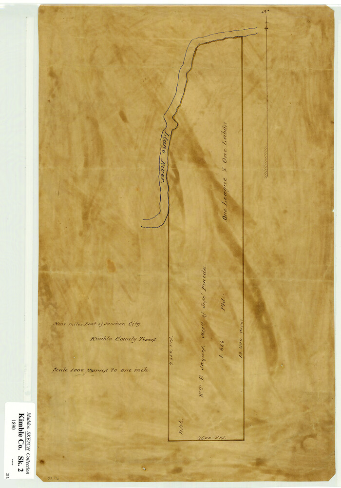
Print $3.00
- Digital $50.00
[Wm. B. Jaques assee. of José Pineda, Kimble County, Texas]
Size: 16.1 x 11.2 inches
540
[Littlefield & White Survey, Kimble County, Texas]
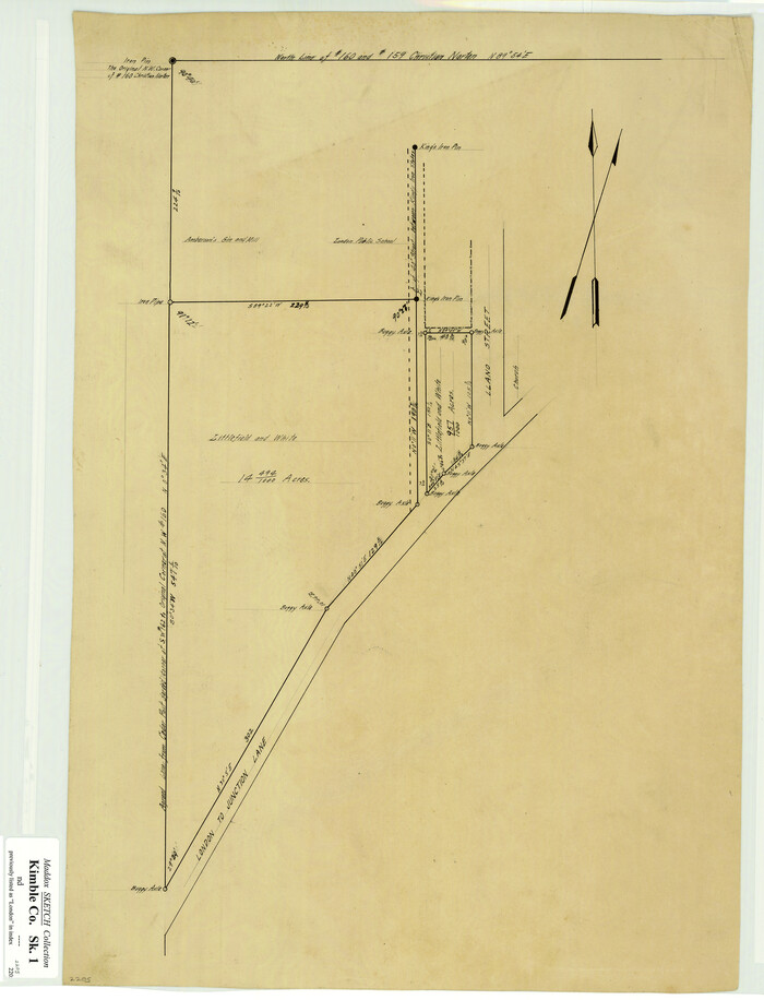
Print $20.00
- Digital $50.00
[Littlefield & White Survey, Kimble County, Texas]
Size: 18.6 x 14.2 inches
570
Working Sketch of surveys in Mason, Kimble & Menard Counties

Print $20.00
- Digital $50.00
Working Sketch of surveys in Mason, Kimble & Menard Counties
1900
Size: 32.1 x 42.4 inches
75805
Water-Shed of the Colorado River

Print $40.00
- Digital $50.00
Water-Shed of the Colorado River
1925
Size: 37.1 x 79.8 inches
65261
Sutton County Working Sketch 29

Print $20.00
- Digital $50.00
Sutton County Working Sketch 29
1917
Size: 15.8 x 13.6 inches
62372
Sutton County Rolled Sketch 66

Print $20.00
- Digital $50.00
Sutton County Rolled Sketch 66
Size: 25.3 x 25.1 inches
7901
Sutton County Rolled Sketch 61

Print $20.00
- Digital $50.00
Sutton County Rolled Sketch 61
1890
Size: 27.8 x 23.4 inches
7898
Sutton County Rolled Sketch 50

Print $40.00
- Digital $50.00
Sutton County Rolled Sketch 50
1950
Size: 55.5 x 44.4 inches
9975
Saline Ranch in Mason, Kimble and Menard Counties

Print $20.00
- Digital $50.00
Saline Ranch in Mason, Kimble and Menard Counties
1916
Size: 28.3 x 27.2 inches
75806
Saline Ranch in Mason, Kimble and Menard Counties

Print $20.00
- Digital $50.00
Saline Ranch in Mason, Kimble and Menard Counties
1916
Size: 28.2 x 27.1 inches
75807
Saline Ranch in Mason, Kimble and Menard Counties

Print $20.00
- Digital $50.00
Saline Ranch in Mason, Kimble and Menard Counties
1916
Size: 28.6 x 27.4 inches
75808
Menard County Working Sketch 28

Print $20.00
- Digital $50.00
Menard County Working Sketch 28
1963
Size: 24.3 x 37.7 inches
70975
Menard County Working Sketch 12

Print $20.00
- Digital $50.00
Menard County Working Sketch 12
1939
Size: 24.7 x 30.0 inches
70959
Menard County Sketch File 3

Print $40.00
- Digital $50.00
Menard County Sketch File 3
Size: 16.3 x 12.9 inches
31488
Menard County Sketch File 18

Print $62.00
- Digital $50.00
Menard County Sketch File 18
1893
Size: 8.7 x 8.1 inches
31516
Menard County Rolled Sketch 6

Print $20.00
- Digital $50.00
Menard County Rolled Sketch 6
Size: 17.3 x 21.2 inches
6755
Mason County Working Sketch 2

Print $20.00
- Digital $50.00
Mason County Working Sketch 2
1900
Size: 31.6 x 36.3 inches
70838
Mason County Sketch File 12

Print $22.00
- Digital $50.00
Mason County Sketch File 12
Size: 15.8 x 12.9 inches
30699
Mason County Rolled Sketch 3

Print $20.00
- Digital $50.00
Mason County Rolled Sketch 3
1965
Size: 30.3 x 22.8 inches
6676
Map of Kimble County, Texas

Print $20.00
- Digital $50.00
Map of Kimble County, Texas
1879
Size: 18.1 x 28.3 inches
527
Map of Kimble County, 1860

Print $20.00
- Digital $50.00
Map of Kimble County, 1860
1860
Size: 20.7 x 30.5 inches
3769
Map of Kimble County

Print $20.00
- Digital $50.00
Map of Kimble County
1879
Size: 18.7 x 28.9 inches
3765
Map of Kimble County

Print $20.00
- Digital $50.00
Map of Kimble County
1878
Size: 19.7 x 29.0 inches
3766
Map of Kimble County

Print $20.00
- Digital $50.00
Map of Kimble County
1876
Size: 19.2 x 29.8 inches
3768
Map of Kimble County

Print $40.00
- Digital $50.00
Map of Kimble County
1890
Size: 36.1 x 54.4 inches
78436
Map of Fisher and Miller's Colony made from the records in the Office of the District Surveyor of Bexar comprising also all the recent surveys

Print $20.00
- Digital $50.00
Map of Fisher and Miller's Colony made from the records in the Office of the District Surveyor of Bexar comprising also all the recent surveys
1855
Size: 23.7 x 35.2 inches
1971
Map of Fisher and Miller's Colony made from the records in the Office of the District Surveyor of Bexar comprising also all the recent surveys

Print $20.00
- Digital $50.00
Map of Fisher and Miller's Colony made from the records in the Office of the District Surveyor of Bexar comprising also all the recent surveys
1855
Size: 27.2 x 39.6 inches
82026
Littlefield and White's London Property

Print $20.00
- Digital $50.00
Littlefield and White's London Property
1916
Size: 18.5 x 13.0 inches
75796
Kimble County Working Sketch Graphic Index, Sheet 2 (Sketches 47 to Most Recent)

Print $40.00
- Digital $50.00
Kimble County Working Sketch Graphic Index, Sheet 2 (Sketches 47 to Most Recent)
1930
Size: 41.1 x 49.0 inches
76607
Kimble County Working Sketch Graphic Index, Sheet 1 (Sketches 1 to 46)

Print $40.00
- Digital $50.00
Kimble County Working Sketch Graphic Index, Sheet 1 (Sketches 1 to 46)
1930
Size: 41.2 x 49.6 inches
76606
[Wm. B. Jaques assee. of José Pineda, Kimble County, Texas]
Print $3.00
- Digital $50.00
[Wm. B. Jaques assee. of José Pineda, Kimble County, Texas]
-
Size
16.1 x 11.2 inches
-
Map/Doc
540
[Littlefield & White Survey, Kimble County, Texas]
Print $20.00
- Digital $50.00
[Littlefield & White Survey, Kimble County, Texas]
-
Size
18.6 x 14.2 inches
-
Map/Doc
570
Working Sketch of surveys in Mason, Kimble & Menard Counties
Print $20.00
- Digital $50.00
Working Sketch of surveys in Mason, Kimble & Menard Counties
1900
-
Size
32.1 x 42.4 inches
-
Map/Doc
75805
-
Creation Date
1900
Water-Shed of the Colorado River
Print $40.00
- Digital $50.00
Water-Shed of the Colorado River
1925
-
Size
37.1 x 79.8 inches
-
Map/Doc
65261
-
Creation Date
1925
Sutton County Working Sketch 29
Print $20.00
- Digital $50.00
Sutton County Working Sketch 29
1917
-
Size
15.8 x 13.6 inches
-
Map/Doc
62372
-
Creation Date
1917
Sutton County Rolled Sketch 66
Print $20.00
- Digital $50.00
Sutton County Rolled Sketch 66
-
Size
25.3 x 25.1 inches
-
Map/Doc
7901
Sutton County Rolled Sketch 61
Print $20.00
- Digital $50.00
Sutton County Rolled Sketch 61
1890
-
Size
27.8 x 23.4 inches
-
Map/Doc
7898
-
Creation Date
1890
Sutton County Rolled Sketch 50
Print $40.00
- Digital $50.00
Sutton County Rolled Sketch 50
1950
-
Size
55.5 x 44.4 inches
-
Map/Doc
9975
-
Creation Date
1950
Saline Ranch in Mason, Kimble and Menard Counties
Print $20.00
- Digital $50.00
Saline Ranch in Mason, Kimble and Menard Counties
1916
-
Size
28.3 x 27.2 inches
-
Map/Doc
75806
-
Creation Date
1916
Saline Ranch in Mason, Kimble and Menard Counties
Print $20.00
- Digital $50.00
Saline Ranch in Mason, Kimble and Menard Counties
1916
-
Size
28.2 x 27.1 inches
-
Map/Doc
75807
-
Creation Date
1916
Saline Ranch in Mason, Kimble and Menard Counties
Print $20.00
- Digital $50.00
Saline Ranch in Mason, Kimble and Menard Counties
1916
-
Size
28.6 x 27.4 inches
-
Map/Doc
75808
-
Creation Date
1916
Menard County Working Sketch 28
Print $20.00
- Digital $50.00
Menard County Working Sketch 28
1963
-
Size
24.3 x 37.7 inches
-
Map/Doc
70975
-
Creation Date
1963
Menard County Working Sketch 12
Print $20.00
- Digital $50.00
Menard County Working Sketch 12
1939
-
Size
24.7 x 30.0 inches
-
Map/Doc
70959
-
Creation Date
1939
Menard County Sketch File 3
Print $40.00
- Digital $50.00
Menard County Sketch File 3
-
Size
16.3 x 12.9 inches
-
Map/Doc
31488
Menard County Sketch File 18
Print $62.00
- Digital $50.00
Menard County Sketch File 18
1893
-
Size
8.7 x 8.1 inches
-
Map/Doc
31516
-
Creation Date
1893
Menard County Rolled Sketch 6
Print $20.00
- Digital $50.00
Menard County Rolled Sketch 6
-
Size
17.3 x 21.2 inches
-
Map/Doc
6755
Mason County Working Sketch 2
Print $20.00
- Digital $50.00
Mason County Working Sketch 2
1900
-
Size
31.6 x 36.3 inches
-
Map/Doc
70838
-
Creation Date
1900
Mason County Sketch File 12
Print $22.00
- Digital $50.00
Mason County Sketch File 12
-
Size
15.8 x 12.9 inches
-
Map/Doc
30699
Mason County Rolled Sketch 3
Print $20.00
- Digital $50.00
Mason County Rolled Sketch 3
1965
-
Size
30.3 x 22.8 inches
-
Map/Doc
6676
-
Creation Date
1965
Map of Kimble County, Texas
Print $20.00
- Digital $50.00
Map of Kimble County, Texas
1879
-
Size
18.1 x 28.3 inches
-
Map/Doc
527
-
Creation Date
1879
Map of Kimble County, 1860
Print $20.00
- Digital $50.00
Map of Kimble County, 1860
1860
-
Size
20.7 x 30.5 inches
-
Map/Doc
3769
-
Creation Date
1860
Map of Kimble County
Print $20.00
- Digital $50.00
Map of Kimble County
1879
-
Size
18.7 x 28.9 inches
-
Map/Doc
3765
-
Creation Date
1879
Map of Kimble County
Print $20.00
- Digital $50.00
Map of Kimble County
1878
-
Size
19.7 x 29.0 inches
-
Map/Doc
3766
-
Creation Date
1878
Map of Kimble County
Print $20.00
- Digital $50.00
Map of Kimble County
1876
-
Size
19.2 x 29.8 inches
-
Map/Doc
3768
-
Creation Date
1876
Map of Kimble County
Print $40.00
- Digital $50.00
Map of Kimble County
1890
-
Size
36.1 x 54.4 inches
-
Map/Doc
78436
-
Creation Date
1890
Map of Fisher and Miller's Colony made from the records in the Office of the District Surveyor of Bexar comprising also all the recent surveys
Print $20.00
- Digital $50.00
Map of Fisher and Miller's Colony made from the records in the Office of the District Surveyor of Bexar comprising also all the recent surveys
1855
-
Size
23.7 x 35.2 inches
-
Map/Doc
1971
-
Creation Date
1855
Map of Fisher and Miller's Colony made from the records in the Office of the District Surveyor of Bexar comprising also all the recent surveys
Print $20.00
- Digital $50.00
Map of Fisher and Miller's Colony made from the records in the Office of the District Surveyor of Bexar comprising also all the recent surveys
1855
-
Size
27.2 x 39.6 inches
-
Map/Doc
82026
-
Creation Date
1855
Littlefield and White's London Property
Print $20.00
- Digital $50.00
Littlefield and White's London Property
1916
-
Size
18.5 x 13.0 inches
-
Map/Doc
75796
-
Creation Date
1916
Kimble County Working Sketch Graphic Index, Sheet 2 (Sketches 47 to Most Recent)
Print $40.00
- Digital $50.00
Kimble County Working Sketch Graphic Index, Sheet 2 (Sketches 47 to Most Recent)
1930
-
Size
41.1 x 49.0 inches
-
Map/Doc
76607
-
Creation Date
1930
Kimble County Working Sketch Graphic Index, Sheet 1 (Sketches 1 to 46)
Print $40.00
- Digital $50.00
Kimble County Working Sketch Graphic Index, Sheet 1 (Sketches 1 to 46)
1930
-
Size
41.2 x 49.6 inches
-
Map/Doc
76606
-
Creation Date
1930