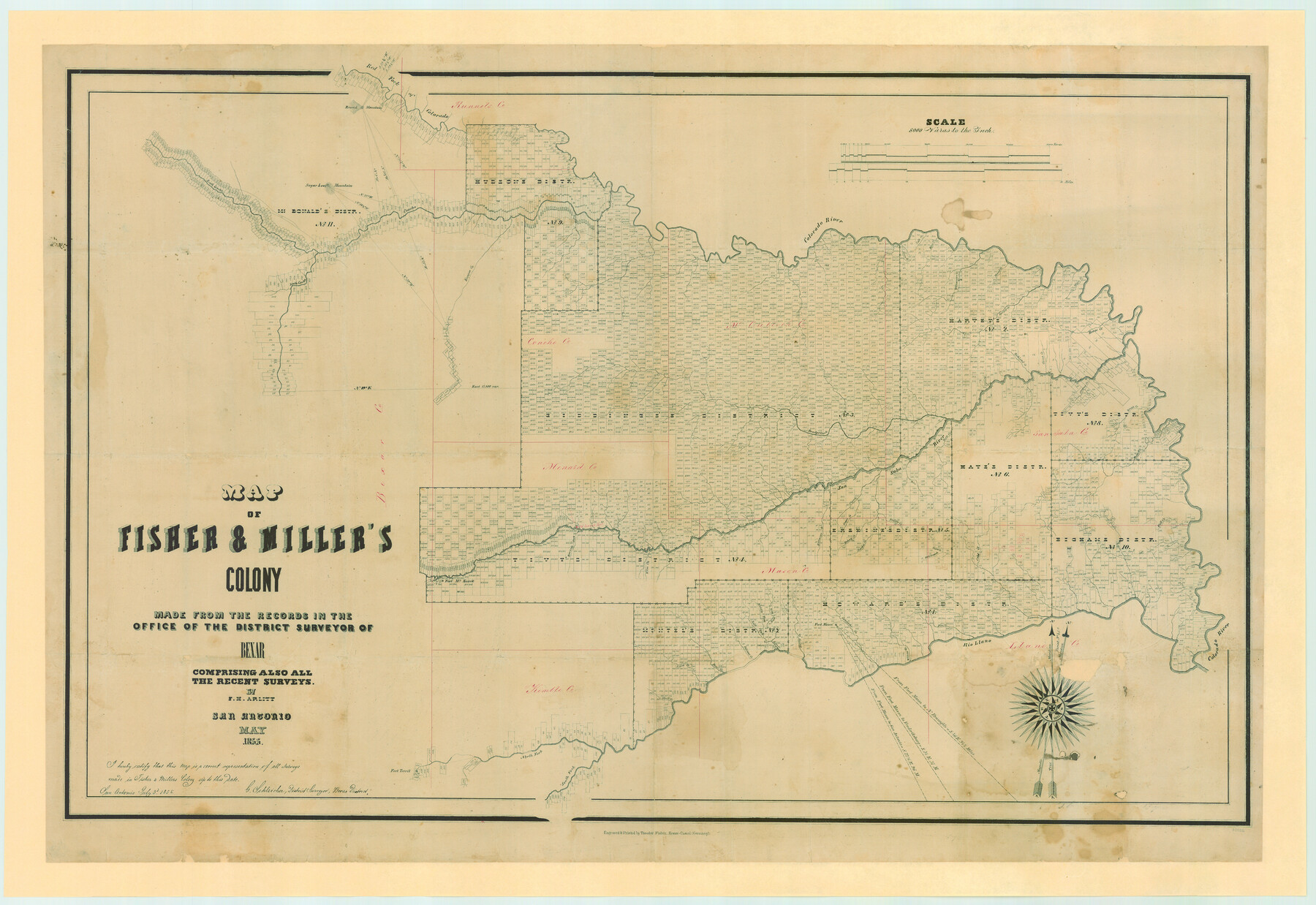
Map of Fisher and Miller's Colony made from the records in the Office of the District Surveyor of Bexar comprising also all the recent surveys
-
Map/Doc
82026
-
Collection
General Map Collection
-
Object Dates
1855 (Creation Date)
-
People and Organizations
Theodor Fisher (Printer)
Gustav Schleicher (Surveyor/Engineer)
F.H. Arlitt (Draftsman)
Anne Jones (Donor)
Jack Jones (Donor)
Kristy Bragg Staats (Donor)
-
Counties
Bexar Concho Menard Kimble Mason McCulloch Runnels San Saba Llano
-
Subjects
Colony
-
Height x Width
27.2 x 39.6 inches
69.1 x 100.6 cm
-
Medium
paper, etching/engraving/lithograph
-
Scale
1:8000
-
Comments
Map donated by Anne and Jack Jones and Kristy Bragg Staats, descendants of D. C. Cowan.
Conservation funded in 2006 by Friends of the Texas General Land Office. -
Features
Hickory Creek
Richland Creek
Simpson Creek
Horse Creek
Rough Creek
China Creek
Bonnet Creek
Marble Creek
San Saba River
Deer Creek
Buffalo Creek
Tiger Creek
Grape Creek
North Concho River
Katemsys Creek
Brady's Creek
Old Spanish Fort
Howard's Creek
Fort McKavett
Elm Creek
Ionia Creek
Bear Creek
Salt Fork [of Leon Creek]
Middle Fork [of Leon Creek]
East Fork [of Leon Creek]
Round Mountain
Honey Creek
Fort Mason
Comanche Creek
Willow Creek
Rio Llano
Fernando Creek
Colorado River
Bluff Creek
Fort Territ
North Fork [of Rio Llano]
South Fork [of Rio Llano]
Leon Creek
Red Fork of Colorado River
Waco Creek
Spring Creek
Mound Creek
Williargers Creek
Elm Creek
Deep Creek
Kicapoo [sic] Creek
Concho River
Sugar Loaf Mountain
South Concho River
Part of: General Map Collection
Gaines County Working Sketch 6

Print $20.00
- Digital $50.00
Gaines County Working Sketch 6
1940
Size 25.0 x 40.8 inches
Map/Doc 69306
Starr County Rolled Sketch 27

Print $20.00
- Digital $50.00
Starr County Rolled Sketch 27
1940
Size 21.4 x 28.6 inches
Map/Doc 7810
Edwards County Working Sketch 118

Print $20.00
- Digital $50.00
Edwards County Working Sketch 118
1974
Size 19.5 x 30.4 inches
Map/Doc 68994
Rockwall County Sketch File 3

Print $6.00
Rockwall County Sketch File 3
1851
Size 17.2 x 11.6 inches
Map/Doc 35417
Wilbarger County Working Sketch 3

Print $20.00
- Digital $50.00
Wilbarger County Working Sketch 3
1923
Size 22.0 x 23.9 inches
Map/Doc 72541

Concho County Sketch File 18

Print $32.00
- Digital $50.00
Concho County Sketch File 18
1898
Size 9.1 x 4.4 inches
Map/Doc 19137
El Paso County Rolled Sketch 50

Print $40.00
- Digital $50.00
El Paso County Rolled Sketch 50
1956
Size 20.7 x 80.1 inches
Map/Doc 8876
Washington County Working Sketch Graphic Index

Print $20.00
- Digital $50.00
Washington County Working Sketch Graphic Index
1976
Size 31.3 x 46.8 inches
Map/Doc 76733
Edwards County Working Sketch 114

Print $20.00
- Digital $50.00
Edwards County Working Sketch 114
1972
Size 33.6 x 33.1 inches
Map/Doc 68990
Reeves County Sketch File 21

Print $20.00
- Digital $50.00
Reeves County Sketch File 21
Size 21.9 x 21.7 inches
Map/Doc 12246
Montague County Working Sketch 2

Print $20.00
- Digital $50.00
Montague County Working Sketch 2
1923
Size 14.4 x 19.9 inches
Map/Doc 71068
You may also like
Flight Mission No. DQN-2K, Frame 134, Calhoun County

Print $20.00
- Digital $50.00
Flight Mission No. DQN-2K, Frame 134, Calhoun County
1953
Size 18.8 x 22.4 inches
Map/Doc 84303
Sabine and Neches Rivers

Print $20.00
- Digital $50.00
Sabine and Neches Rivers
Size 19.6 x 43.7 inches
Map/Doc 94444
Andrews County

Print $40.00
- Digital $50.00
Andrews County
1925
Size 42.6 x 57.1 inches
Map/Doc 66703
Presidio County Rolled Sketch A-2

Print $20.00
- Digital $50.00
Presidio County Rolled Sketch A-2
1889
Size 36.9 x 43.9 inches
Map/Doc 9770
Jim Hogg County Rolled Sketch 6

Print $40.00
- Digital $50.00
Jim Hogg County Rolled Sketch 6
1943
Size 51.9 x 38.4 inches
Map/Doc 9322
Lavaca County Boundary File 58

Print $20.00
- Digital $50.00
Lavaca County Boundary File 58
Size 8.5 x 7.1 inches
Map/Doc 56259
Harris County Rolled Sketch 96B

Print $20.00
- Digital $50.00
Harris County Rolled Sketch 96B
Size 15.8 x 15.6 inches
Map/Doc 10681
Jefferson County Rolled Sketch 61B

Print $20.00
- Digital $50.00
Jefferson County Rolled Sketch 61B
1928
Size 27.3 x 40.3 inches
Map/Doc 6411
Kerr County Working Sketch 18

Print $20.00
- Digital $50.00
Kerr County Working Sketch 18
1956
Size 25.4 x 29.3 inches
Map/Doc 70049
McLennan County Sketch File 21

Print $4.00
- Digital $50.00
McLennan County Sketch File 21
Size 9.0 x 8.2 inches
Map/Doc 31294
Jefferson County Sketch File 33

Print $32.00
- Digital $50.00
Jefferson County Sketch File 33
1934
Size 8.2 x 7.6 inches
Map/Doc 28197
Wise County Sketch File 32

Print $5.00
- Digital $50.00
Wise County Sketch File 32
1880
Size 16.4 x 11.0 inches
Map/Doc 40588