Montague County Working Sketch 2
-
Map/Doc
71068
-
Collection
General Map Collection
-
Object Dates
3/16/1923 (Creation Date)
-
People and Organizations
J. Bascom Giles (Draftsman)
-
Counties
Montague Clay
-
Subjects
Surveying Working Sketch
-
Height x Width
14.4 x 19.9 inches
36.6 x 50.6 cm
-
Scale
1" = 1000 varas
Part of: General Map Collection
Aransas County Rolled Sketch 2

Print $20.00
- Digital $50.00
Aransas County Rolled Sketch 2
1950
Size 21.4 x 24.4 inches
Map/Doc 73615
Flight Mission No. DQN-1K, Frame 77, Calhoun County

Print $20.00
- Digital $50.00
Flight Mission No. DQN-1K, Frame 77, Calhoun County
1953
Size 18.5 x 22.2 inches
Map/Doc 84162
Presidio County Sketch File 59

Print $12.00
- Digital $50.00
Presidio County Sketch File 59
1935
Size 8.7 x 7.5 inches
Map/Doc 34637
Coke County Working Sketch 24

Print $20.00
- Digital $50.00
Coke County Working Sketch 24
1956
Size 28.7 x 31.1 inches
Map/Doc 68061
Harris County Working Sketch 45

Print $20.00
- Digital $50.00
Harris County Working Sketch 45
1942
Size 26.6 x 31.9 inches
Map/Doc 65937
Chambers County Working Sketch 12

Print $20.00
- Digital $50.00
Chambers County Working Sketch 12
1954
Size 35.2 x 33.8 inches
Map/Doc 67995
Reeves County Sketch File 9

Print $20.00
- Digital $50.00
Reeves County Sketch File 9
Size 46.3 x 38.2 inches
Map/Doc 10587
Sabine County

Print $20.00
- Digital $50.00
Sabine County
1920
Size 43.9 x 34.6 inches
Map/Doc 63014
Leon County Sketch File 29

Print $8.00
- Digital $50.00
Leon County Sketch File 29
1951
Size 11.2 x 8.8 inches
Map/Doc 29825
Map of Nacogdoches County

Print $40.00
- Digital $50.00
Map of Nacogdoches County
1839
Size 81.0 x 38.5 inches
Map/Doc 93375

Zavala County Rolled Sketch 31

Print $20.00
- Digital $50.00
Zavala County Rolled Sketch 31
1883
Size 37.4 x 27.1 inches
Map/Doc 8332
You may also like
Aransas Pass to Baffin Bay

Print $20.00
- Digital $50.00
Aransas Pass to Baffin Bay
1981
Size 43.0 x 35.0 inches
Map/Doc 73420
Starr County Sketch File 49

Print $20.00
- Digital $50.00
Starr County Sketch File 49
1951
Size 24.9 x 17.2 inches
Map/Doc 12346
Map of Marion County

Print $20.00
- Digital $50.00
Map of Marion County
1901
Size 31.1 x 41.9 inches
Map/Doc 66915
Young County Working Sketch 6

Print $20.00
- Digital $50.00
Young County Working Sketch 6
1919
Size 12.2 x 11.9 inches
Map/Doc 62029
Map of Prison Property in Walker County, Texas

Print $20.00
- Digital $50.00
Map of Prison Property in Walker County, Texas
Size 37.6 x 42.9 inches
Map/Doc 62993
[Gunter & Munson Maddox Bros. & Anderson Blocks F, O, N, A and vicinity]
![93203, [Gunter & Munson Maddox Bros. & Anderson Blocks F, O, N, A and vicinity], Twichell Survey Records](https://historictexasmaps.com/wmedia_w700/maps/93203-1.tif.jpg)
Print $40.00
- Digital $50.00
[Gunter & Munson Maddox Bros. & Anderson Blocks F, O, N, A and vicinity]
1929
Size 81.0 x 15.2 inches
Map/Doc 93203
Lynn County Rolled Sketch H

Print $20.00
- Digital $50.00
Lynn County Rolled Sketch H
1902
Size 43.6 x 38.4 inches
Map/Doc 9472
Eastland County Rolled Sketch 19

Print $20.00
- Digital $50.00
Eastland County Rolled Sketch 19
1980
Size 28.9 x 30.9 inches
Map/Doc 8825
Howard County Sketch File 15

Print $6.00
- Digital $50.00
Howard County Sketch File 15
Size 11.2 x 8.8 inches
Map/Doc 26875
Crockett County Sketch File A

Print $40.00
- Digital $50.00
Crockett County Sketch File A
Size 21.9 x 7.5 inches
Map/Doc 19624
[Blocks M1 and 3T]
![93008, [Blocks M1 and 3T], Twichell Survey Records](https://historictexasmaps.com/wmedia_w700/maps/93008-1.tif.jpg)
Print $2.00
- Digital $50.00
[Blocks M1 and 3T]
Size 15.6 x 6.4 inches
Map/Doc 93008
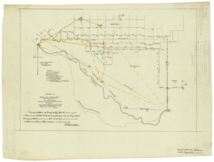
Brewster County Rolled Sketch 24A
Print $20.00
- Digital $50.00
Brewster County Rolled Sketch 24A
1910
Size 19.8 x 26.1 inches
Map/Doc 5208