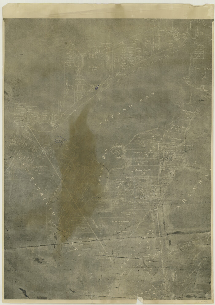
[William Steele Survey near Copano Bay]
Print $20.00
- Digital $50.00
[William Steele Survey near Copano Bay]
1927
Size: 26.1 x 18.4 inches
2082
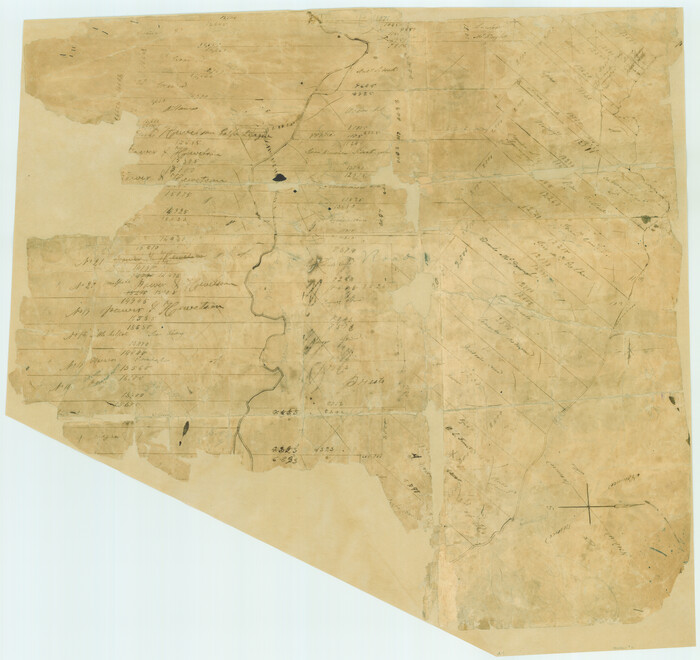
[Surveys in Power and Hewetson's Colony]
Print $20.00
- Digital $50.00
[Surveys in Power and Hewetson's Colony]
1830
Size: 21.3 x 22.5 inches
2
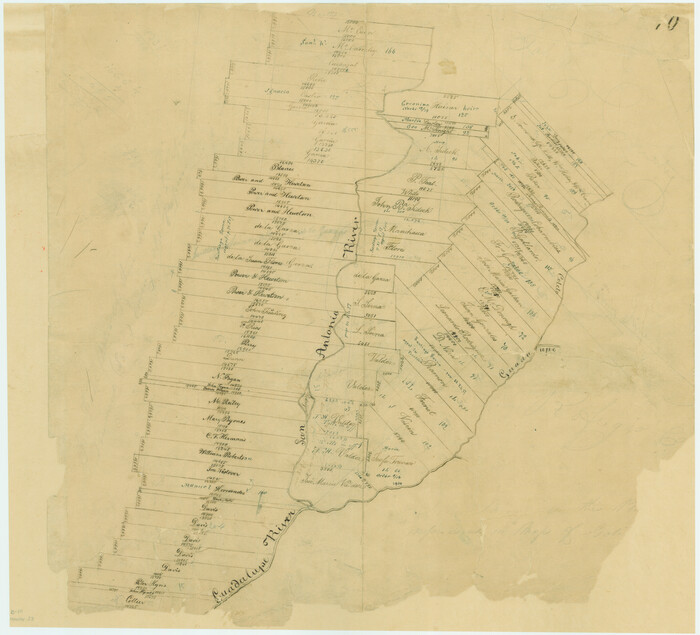
[Surveys in Power and Hewetson's Colony along the San Antonio and Guadalupe Rivers]
Print $20.00
- Digital $50.00
[Surveys in Power and Hewetson's Colony along the San Antonio and Guadalupe Rivers]
1837
Size: 14.9 x 16.5 inches
23
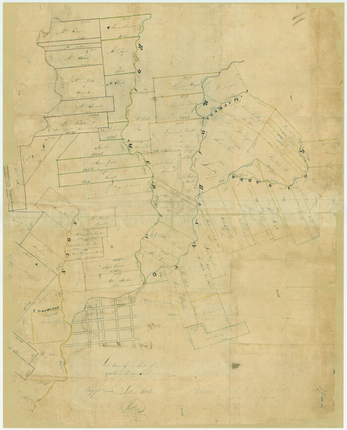
[Surveys in Power and Hewetson's Colony along the Blanco and Medina Rivers]
Print $20.00
- Digital $50.00
[Surveys in Power and Hewetson's Colony along the Blanco and Medina Rivers]
1834
Size: 37.0 x 29.9 inches
46
[Surveys in Power and Hewetson's Colony along the Aransas River, Middle Creek, Papalose Creek, and Blanco Creek]
Print $20.00
- Digital $50.00
[Surveys in Power and Hewetson's Colony along the Aransas River, Middle Creek, Papalose Creek, and Blanco Creek]
1830
Size: 21.6 x 21.2 inches
81
[Atlas C, Table of Contents]
Print $3.00
- Digital $50.00
[Atlas C, Table of Contents]
Size: 14.7 x 9.6 inches
78353
[Aransas and Corpus Christi Bays]
Print $3.00
- Digital $50.00
[Aransas and Corpus Christi Bays]
1839
Size: 11.4 x 16.5 inches
140
West End of Copano Bay and Town of Saint Marys, Texas

Print $40.00
- Digital $50.00
West End of Copano Bay and Town of Saint Marys, Texas
1861
Size: 54.5 x 32.9 inches
73428
Victoria County Working Sketch 2

Print $20.00
- Digital $50.00
Victoria County Working Sketch 2
1939
Size: 43.1 x 28.1 inches
72272
The Republic County of Refugio. Proposed, Late Fall 1837

Print $20.00
The Republic County of Refugio. Proposed, Late Fall 1837
2020
Size: 22.3 x 21.6 inches
96256
The Republic County of Refugio. December 29, 1845

Print $20.00
The Republic County of Refugio. December 29, 1845
2020
Size: 22.3 x 21.6 inches
96258
The Republic County of Refugio. December 2, 1841

Print $20.00
The Republic County of Refugio. December 2, 1841
2020
Size: 22.3 x 21.6 inches
96257
The Coast & Bays of Western Texas

Print $20.00
- Digital $50.00
The Coast & Bays of Western Texas
1857
Size: 18.2 x 23.9 inches
73424
Texas, San Antonio Bay, Hynes Bay

Print $40.00
- Digital $50.00
Texas, San Antonio Bay, Hynes Bay
1934
Size: 33.0 x 48.9 inches
69998
Texas, San Antonio Bay, Guadalupe Bay

Print $40.00
- Digital $50.00
Texas, San Antonio Bay, Guadalupe Bay
1934
Size: 28.8 x 48.4 inches
69999
Texas, Copano Bay, Port Bay

Print $40.00
- Digital $50.00
Texas, Copano Bay, Port Bay
1934
Size: 32.9 x 48.8 inches
73432
Texas, Copano Bay, Mission Bay and Fish Point

Print $40.00
- Digital $50.00
Texas, Copano Bay, Mission Bay and Fish Point
1934
Size: 33.3 x 48.9 inches
73433
Texas, Aransas Bay, Copano Bay and St. Charles Bay

Print $40.00
- Digital $50.00
Texas, Aransas Bay, Copano Bay and St. Charles Bay
1934
Size: 34.0 x 48.6 inches
73434
Texas Intracoastal Waterway - Port O'Connor to San Antonio Bay, Including Pass Cavallo

Print $20.00
- Digital $50.00
Texas Intracoastal Waterway - Port O'Connor to San Antonio Bay, Including Pass Cavallo
1957
Size: 28.1 x 40.0 inches
73372
Texas Intracoastal Waterway - Port O'Connor to San Antonio Bay, Including Pass Cavallo

Print $20.00
- Digital $50.00
Texas Intracoastal Waterway - Port O'Connor to San Antonio Bay, Including Pass Cavallo
1961
Size: 26.5 x 38.7 inches
73373
Texas Aranzas-Bay [sic]
Print $20.00
- Digital $50.00
Texas Aranzas-Bay [sic]
1832
Size: 21.4 x 15.5 inches
145
San Patricio County Sketch File 52

Print $14.00
- Digital $50.00
San Patricio County Sketch File 52
1917
Size: 11.3 x 8.7 inches
36381
San Patricio County Sketch File 51

Print $12.00
- Digital $50.00
San Patricio County Sketch File 51
1917
Size: 11.2 x 8.8 inches
36375
San Patricio County Rolled Sketch 17A

Print $20.00
- Digital $50.00
San Patricio County Rolled Sketch 17A
1917
Size: 15.7 x 23.8 inches
7575
San Patricio County Rolled Sketch 17

Print $20.00
- Digital $50.00
San Patricio County Rolled Sketch 17
1917
Size: 18.1 x 28.1 inches
7574
Rockport Quadrangle

Print $20.00
- Digital $50.00
Rockport Quadrangle
1954
Size: 21.3 x 18.3 inches
73435
Refugio County, Texas

Print $20.00
- Digital $50.00
Refugio County, Texas
1896
Size: 22.6 x 28.8 inches
5024
Refugio County, Texas

Print $20.00
- Digital $50.00
Refugio County, Texas
1879
Size: 19.9 x 29.0 inches
600
Refugio County Working Sketch Graphic Index

Print $20.00
- Digital $50.00
Refugio County Working Sketch Graphic Index
1921
Size: 38.9 x 47.8 inches
76683
[William Steele Survey near Copano Bay]
Print $20.00
- Digital $50.00
[William Steele Survey near Copano Bay]
1927
-
Size
26.1 x 18.4 inches
-
Map/Doc
2082
-
Creation Date
1927
[Surveys in Power and Hewetson's Colony]
Print $20.00
- Digital $50.00
[Surveys in Power and Hewetson's Colony]
1830
-
Size
21.3 x 22.5 inches
-
Map/Doc
2
-
Creation Date
1830
[Surveys in Power and Hewetson's Colony along the San Antonio and Guadalupe Rivers]
Print $20.00
- Digital $50.00
[Surveys in Power and Hewetson's Colony along the San Antonio and Guadalupe Rivers]
1837
-
Size
14.9 x 16.5 inches
-
Map/Doc
23
-
Creation Date
1837
[Surveys in Power and Hewetson's Colony along the Blanco and Medina Rivers]
Print $20.00
- Digital $50.00
[Surveys in Power and Hewetson's Colony along the Blanco and Medina Rivers]
1834
-
Size
37.0 x 29.9 inches
-
Map/Doc
46
-
Creation Date
1834
[Surveys in Power and Hewetson's Colony along the Aransas River, Middle Creek, Papalose Creek, and Blanco Creek]
Print $20.00
- Digital $50.00
[Surveys in Power and Hewetson's Colony along the Aransas River, Middle Creek, Papalose Creek, and Blanco Creek]
1830
-
Size
21.6 x 21.2 inches
-
Map/Doc
81
-
Creation Date
1830
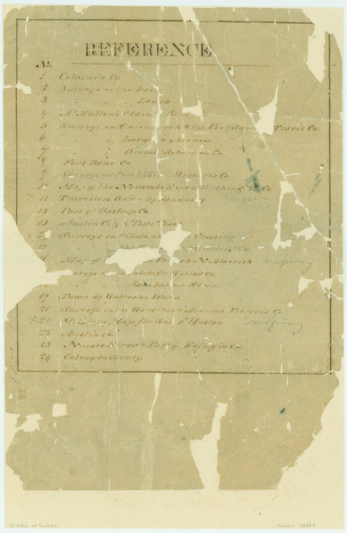
[Atlas C, Table of Contents]
Print $3.00
- Digital $50.00
[Atlas C, Table of Contents]
-
Size
14.7 x 9.6 inches
-
Map/Doc
78353
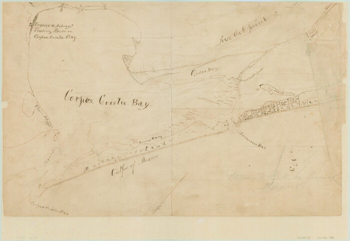
[Aransas and Corpus Christi Bays]
Print $3.00
- Digital $50.00
[Aransas and Corpus Christi Bays]
1839
-
Size
11.4 x 16.5 inches
-
Map/Doc
140
-
Creation Date
1839
West End of Copano Bay and Town of Saint Marys, Texas
Print $40.00
- Digital $50.00
West End of Copano Bay and Town of Saint Marys, Texas
1861
-
Size
54.5 x 32.9 inches
-
Map/Doc
73428
-
Creation Date
1861
Victoria County Working Sketch 2
Print $20.00
- Digital $50.00
Victoria County Working Sketch 2
1939
-
Size
43.1 x 28.1 inches
-
Map/Doc
72272
-
Creation Date
1939
The Republic County of Refugio. Proposed, Late Fall 1837
Print $20.00
The Republic County of Refugio. Proposed, Late Fall 1837
2020
-
Size
22.3 x 21.6 inches
-
Map/Doc
96256
-
Creation Date
2020
The Republic County of Refugio. December 29, 1845
Print $20.00
The Republic County of Refugio. December 29, 1845
2020
-
Size
22.3 x 21.6 inches
-
Map/Doc
96258
-
Creation Date
2020
The Republic County of Refugio. December 2, 1841
Print $20.00
The Republic County of Refugio. December 2, 1841
2020
-
Size
22.3 x 21.6 inches
-
Map/Doc
96257
-
Creation Date
2020
The Coast & Bays of Western Texas
Print $20.00
- Digital $50.00
The Coast & Bays of Western Texas
1857
-
Size
18.2 x 23.9 inches
-
Map/Doc
73424
-
Creation Date
1857
Texas, San Antonio Bay, Hynes Bay
Print $40.00
- Digital $50.00
Texas, San Antonio Bay, Hynes Bay
1934
-
Size
33.0 x 48.9 inches
-
Map/Doc
69998
-
Creation Date
1934
Texas, San Antonio Bay, Guadalupe Bay
Print $40.00
- Digital $50.00
Texas, San Antonio Bay, Guadalupe Bay
1934
-
Size
28.8 x 48.4 inches
-
Map/Doc
69999
-
Creation Date
1934
Texas, Copano Bay, Port Bay
Print $40.00
- Digital $50.00
Texas, Copano Bay, Port Bay
1934
-
Size
32.9 x 48.8 inches
-
Map/Doc
73432
-
Creation Date
1934
Texas, Copano Bay, Mission Bay and Fish Point
Print $40.00
- Digital $50.00
Texas, Copano Bay, Mission Bay and Fish Point
1934
-
Size
33.3 x 48.9 inches
-
Map/Doc
73433
-
Creation Date
1934
Texas, Aransas Bay, Copano Bay and St. Charles Bay
Print $40.00
- Digital $50.00
Texas, Aransas Bay, Copano Bay and St. Charles Bay
1934
-
Size
34.0 x 48.6 inches
-
Map/Doc
73434
-
Creation Date
1934
Texas Intracoastal Waterway - Port O'Connor to San Antonio Bay, Including Pass Cavallo
Print $20.00
- Digital $50.00
Texas Intracoastal Waterway - Port O'Connor to San Antonio Bay, Including Pass Cavallo
1957
-
Size
28.1 x 40.0 inches
-
Map/Doc
73372
-
Creation Date
1957
Texas Intracoastal Waterway - Port O'Connor to San Antonio Bay, Including Pass Cavallo
Print $20.00
- Digital $50.00
Texas Intracoastal Waterway - Port O'Connor to San Antonio Bay, Including Pass Cavallo
1961
-
Size
26.5 x 38.7 inches
-
Map/Doc
73373
-
Creation Date
1961
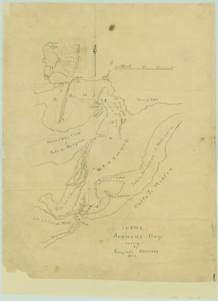
Texas Aranzas-Bay [sic]
Print $20.00
- Digital $50.00
Texas Aranzas-Bay [sic]
1832
-
Size
21.4 x 15.5 inches
-
Map/Doc
145
-
Creation Date
1832
San Patricio County Sketch File 52
Print $14.00
- Digital $50.00
San Patricio County Sketch File 52
1917
-
Size
11.3 x 8.7 inches
-
Map/Doc
36381
-
Creation Date
1917
San Patricio County Sketch File 51
Print $12.00
- Digital $50.00
San Patricio County Sketch File 51
1917
-
Size
11.2 x 8.8 inches
-
Map/Doc
36375
-
Creation Date
1917
San Patricio County Rolled Sketch 17A
Print $20.00
- Digital $50.00
San Patricio County Rolled Sketch 17A
1917
-
Size
15.7 x 23.8 inches
-
Map/Doc
7575
-
Creation Date
1917
San Patricio County Rolled Sketch 17
Print $20.00
- Digital $50.00
San Patricio County Rolled Sketch 17
1917
-
Size
18.1 x 28.1 inches
-
Map/Doc
7574
-
Creation Date
1917
Rockport Quadrangle
Print $20.00
- Digital $50.00
Rockport Quadrangle
1954
-
Size
21.3 x 18.3 inches
-
Map/Doc
73435
-
Creation Date
1954
Refugio District

Print $20.00
- Digital $50.00
Refugio District
1855
-
Size
30.7 x 34.7 inches
-
Map/Doc
2139
-
Creation Date
1855
Refugio County, Texas
Print $20.00
- Digital $50.00
Refugio County, Texas
1896
-
Size
22.6 x 28.8 inches
-
Map/Doc
5024
-
Creation Date
1896
Refugio County, Texas
Print $20.00
- Digital $50.00
Refugio County, Texas
1879
-
Size
19.9 x 29.0 inches
-
Map/Doc
600
-
Creation Date
1879
Refugio County Working Sketch Graphic Index
Print $20.00
- Digital $50.00
Refugio County Working Sketch Graphic Index
1921
-
Size
38.9 x 47.8 inches
-
Map/Doc
76683
-
Creation Date
1921