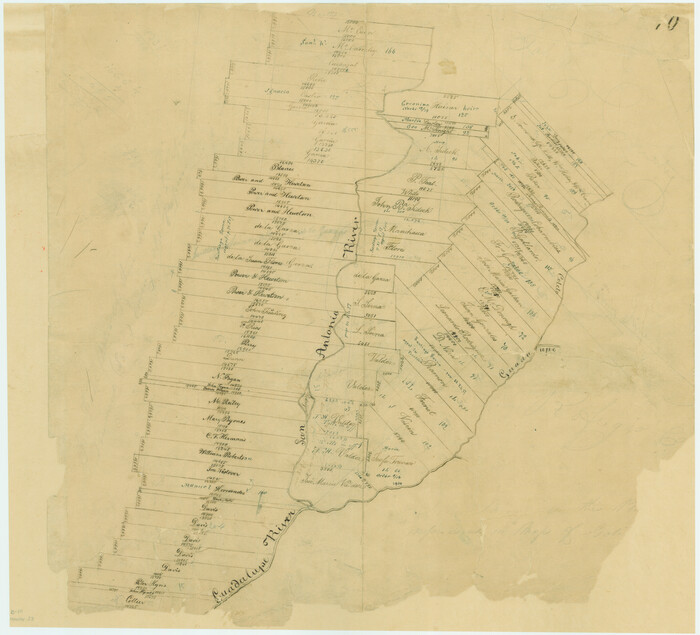
Refugio County Sketch File 19

Print $20.00
- Digital $50.00
Refugio County Sketch File 19
1916
Size: 35.0 x 16.1 inches
12247
Refugio County Sketch File 21

Print $20.00
- Digital $50.00
Refugio County Sketch File 21
1933
Size: 17.8 x 22.1 inches
12248
Refugio County Sketch File 22

Print $20.00
- Digital $50.00
Refugio County Sketch File 22
Size: 16.2 x 22.3 inches
12249
Aransas County Sketch File 1

Print $4.00
- Digital $50.00
Aransas County Sketch File 1
Size: 7.5 x 5.3 inches
13098
Aransas County Sketch File 2

Print $4.00
- Digital $50.00
Aransas County Sketch File 2
Size: 7.4 x 5.0 inches
13100
Aransas County Sketch File 24

Print $36.00
- Digital $50.00
Aransas County Sketch File 24
1938
Size: 10.9 x 8.3 inches
13177
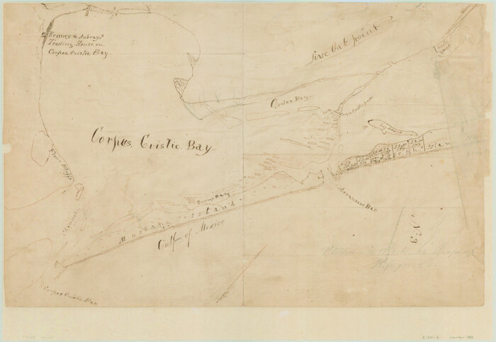
[Aransas and Corpus Christi Bays]
Print $3.00
- Digital $50.00
[Aransas and Corpus Christi Bays]
1839
Size: 11.4 x 16.5 inches
140
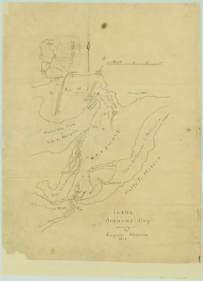
Texas Aranzas-Bay [sic]
Print $20.00
- Digital $50.00
Texas Aranzas-Bay [sic]
1832
Size: 21.4 x 15.5 inches
145
Map of Refugio County

Print $40.00
- Digital $50.00
Map of Refugio County
1900
Size: 35.9 x 50.4 inches
16799
Map of Refugio District

Print $20.00
- Digital $50.00
Map of Refugio District
1850
Size: 22.6 x 25.1 inches
1959
[Surveys in Power and Hewetson's Colony]
Print $20.00
- Digital $50.00
[Surveys in Power and Hewetson's Colony]
1830
Size: 21.3 x 22.5 inches
2
[William Steele Survey near Copano Bay]
Print $20.00
- Digital $50.00
[William Steele Survey near Copano Bay]
1927
Size: 26.1 x 18.4 inches
2082
[Surveys in Power and Hewetson's Colony along the San Antonio and Guadalupe Rivers]
Print $20.00
- Digital $50.00
[Surveys in Power and Hewetson's Colony along the San Antonio and Guadalupe Rivers]
1837
Size: 14.9 x 16.5 inches
23
Goliad County Sketch File 11

Print $40.00
- Digital $50.00
Goliad County Sketch File 11
Size: 13.4 x 12.5 inches
24228
Goliad County Sketch File 20

Print $38.00
- Digital $50.00
Goliad County Sketch File 20
1887
Size: 8.8 x 12.3 inches
24265
Goliad County Sketch File 31

Print $6.00
- Digital $50.00
Goliad County Sketch File 31
1897
Size: 10.7 x 8.2 inches
24329
Aransas Migratory Waterfowl Refuge in Aransas and Refugio Counties

Print $20.00
- Digital $50.00
Aransas Migratory Waterfowl Refuge in Aransas and Refugio Counties
1937
Size: 40.3 x 31.0 inches
2693
Aransas Migratory Waterfowl Refuge, San Antonio Loan & Trust Company Tracts, 45,596.98 acres, Aransas and Refugio Counties

Print $20.00
- Digital $50.00
Aransas Migratory Waterfowl Refuge, San Antonio Loan & Trust Company Tracts, 45,596.98 acres, Aransas and Refugio Counties
1937
Size: 41.1 x 30.8 inches
3073
Refugio County Sketch File 1

Print $8.00
- Digital $50.00
Refugio County Sketch File 1
1846
Size: 12.6 x 7.8 inches
35235
Refugio County Sketch File 2

Print $6.00
- Digital $50.00
Refugio County Sketch File 2
1846
Size: 12.6 x 7.7 inches
35238
Refugio County Sketch File 3

Print $8.00
- Digital $50.00
Refugio County Sketch File 3
1849
Size: 12.9 x 8.6 inches
35241
Refugio County Sketch File 5

Print $8.00
- Digital $50.00
Refugio County Sketch File 5
1849
Size: 12.8 x 8.3 inches
35245
Refugio County Sketch File 6

Print $4.00
- Digital $50.00
Refugio County Sketch File 6
1856
Size: 8.0 x 13.7 inches
35249
Refugio County Sketch File 7

Print $4.00
- Digital $50.00
Refugio County Sketch File 7
1875
Size: 12.1 x 7.6 inches
35251
Refugio County Sketch File 8a

Print $2.00
- Digital $50.00
Refugio County Sketch File 8a
Size: 8.1 x 10.2 inches
35253
Refugio County Sketch File 8b

Print $4.00
- Digital $50.00
Refugio County Sketch File 8b
1876
Size: 8.5 x 10.5 inches
35254
Refugio County Sketch File 9

Print $4.00
- Digital $50.00
Refugio County Sketch File 9
1850
Size: 5.5 x 7.6 inches
35256
Refugio County Sketch File 10

Print $4.00
- Digital $50.00
Refugio County Sketch File 10
Size: 8.2 x 9.4 inches
35258
Refugio County Sketch File 11

Print $6.00
- Digital $50.00
Refugio County Sketch File 11
Size: 8.0 x 8.2 inches
35260
Refugio County Sketch File 19
Print $20.00
- Digital $50.00
Refugio County Sketch File 19
1916
-
Size
35.0 x 16.1 inches
-
Map/Doc
12247
-
Creation Date
1916
Refugio County Sketch File 21
Print $20.00
- Digital $50.00
Refugio County Sketch File 21
1933
-
Size
17.8 x 22.1 inches
-
Map/Doc
12248
-
Creation Date
1933
Refugio County Sketch File 22
Print $20.00
- Digital $50.00
Refugio County Sketch File 22
-
Size
16.2 x 22.3 inches
-
Map/Doc
12249
Aransas County Sketch File 1
Print $4.00
- Digital $50.00
Aransas County Sketch File 1
-
Size
7.5 x 5.3 inches
-
Map/Doc
13098
Aransas County Sketch File 2
Print $4.00
- Digital $50.00
Aransas County Sketch File 2
-
Size
7.4 x 5.0 inches
-
Map/Doc
13100
Aransas County Sketch File 24
Print $36.00
- Digital $50.00
Aransas County Sketch File 24
1938
-
Size
10.9 x 8.3 inches
-
Map/Doc
13177
-
Creation Date
1938
[Aransas and Corpus Christi Bays]
Print $3.00
- Digital $50.00
[Aransas and Corpus Christi Bays]
1839
-
Size
11.4 x 16.5 inches
-
Map/Doc
140
-
Creation Date
1839
Texas Aranzas-Bay [sic]
Print $20.00
- Digital $50.00
Texas Aranzas-Bay [sic]
1832
-
Size
21.4 x 15.5 inches
-
Map/Doc
145
-
Creation Date
1832
Map of Refugio County
Print $40.00
- Digital $50.00
Map of Refugio County
1900
-
Size
35.9 x 50.4 inches
-
Map/Doc
16799
-
Creation Date
1900
Map of Refugio District
Print $20.00
- Digital $50.00
Map of Refugio District
1850
-
Size
22.6 x 25.1 inches
-
Map/Doc
1959
-
Creation Date
1850
[Surveys in Power and Hewetson's Colony]
Print $20.00
- Digital $50.00
[Surveys in Power and Hewetson's Colony]
1830
-
Size
21.3 x 22.5 inches
-
Map/Doc
2
-
Creation Date
1830
[William Steele Survey near Copano Bay]
Print $20.00
- Digital $50.00
[William Steele Survey near Copano Bay]
1927
-
Size
26.1 x 18.4 inches
-
Map/Doc
2082
-
Creation Date
1927
Refugio District

Print $20.00
- Digital $50.00
Refugio District
1855
-
Size
30.7 x 34.7 inches
-
Map/Doc
2139
-
Creation Date
1855
[Surveys in Power and Hewetson's Colony along the San Antonio and Guadalupe Rivers]
Print $20.00
- Digital $50.00
[Surveys in Power and Hewetson's Colony along the San Antonio and Guadalupe Rivers]
1837
-
Size
14.9 x 16.5 inches
-
Map/Doc
23
-
Creation Date
1837
Goliad County Sketch File 11
Print $40.00
- Digital $50.00
Goliad County Sketch File 11
-
Size
13.4 x 12.5 inches
-
Map/Doc
24228
Goliad County Sketch File 20
Print $38.00
- Digital $50.00
Goliad County Sketch File 20
1887
-
Size
8.8 x 12.3 inches
-
Map/Doc
24265
-
Creation Date
1887
Goliad County Sketch File 31
Print $6.00
- Digital $50.00
Goliad County Sketch File 31
1897
-
Size
10.7 x 8.2 inches
-
Map/Doc
24329
-
Creation Date
1897
Aransas Migratory Waterfowl Refuge in Aransas and Refugio Counties
Print $20.00
- Digital $50.00
Aransas Migratory Waterfowl Refuge in Aransas and Refugio Counties
1937
-
Size
40.3 x 31.0 inches
-
Map/Doc
2693
-
Creation Date
1937
Aransas Migratory Waterfowl Refuge, San Antonio Loan & Trust Company Tracts, 45,596.98 acres, Aransas and Refugio Counties
Print $20.00
- Digital $50.00
Aransas Migratory Waterfowl Refuge, San Antonio Loan & Trust Company Tracts, 45,596.98 acres, Aransas and Refugio Counties
1937
-
Size
41.1 x 30.8 inches
-
Map/Doc
3073
-
Creation Date
1937
Refugio County Sketch File 1
Print $8.00
- Digital $50.00
Refugio County Sketch File 1
1846
-
Size
12.6 x 7.8 inches
-
Map/Doc
35235
-
Creation Date
1846
Refugio County Sketch File 2
Print $6.00
- Digital $50.00
Refugio County Sketch File 2
1846
-
Size
12.6 x 7.7 inches
-
Map/Doc
35238
-
Creation Date
1846
Refugio County Sketch File 3
Print $8.00
- Digital $50.00
Refugio County Sketch File 3
1849
-
Size
12.9 x 8.6 inches
-
Map/Doc
35241
-
Creation Date
1849
Refugio County Sketch File 5
Print $8.00
- Digital $50.00
Refugio County Sketch File 5
1849
-
Size
12.8 x 8.3 inches
-
Map/Doc
35245
-
Creation Date
1849
Refugio County Sketch File 6
Print $4.00
- Digital $50.00
Refugio County Sketch File 6
1856
-
Size
8.0 x 13.7 inches
-
Map/Doc
35249
-
Creation Date
1856
Refugio County Sketch File 7
Print $4.00
- Digital $50.00
Refugio County Sketch File 7
1875
-
Size
12.1 x 7.6 inches
-
Map/Doc
35251
-
Creation Date
1875
Refugio County Sketch File 8a
Print $2.00
- Digital $50.00
Refugio County Sketch File 8a
-
Size
8.1 x 10.2 inches
-
Map/Doc
35253
Refugio County Sketch File 8b
Print $4.00
- Digital $50.00
Refugio County Sketch File 8b
1876
-
Size
8.5 x 10.5 inches
-
Map/Doc
35254
-
Creation Date
1876
Refugio County Sketch File 9
Print $4.00
- Digital $50.00
Refugio County Sketch File 9
1850
-
Size
5.5 x 7.6 inches
-
Map/Doc
35256
-
Creation Date
1850
Refugio County Sketch File 10
Print $4.00
- Digital $50.00
Refugio County Sketch File 10
-
Size
8.2 x 9.4 inches
-
Map/Doc
35258
Refugio County Sketch File 11
Print $6.00
- Digital $50.00
Refugio County Sketch File 11
-
Size
8.0 x 8.2 inches
-
Map/Doc
35260