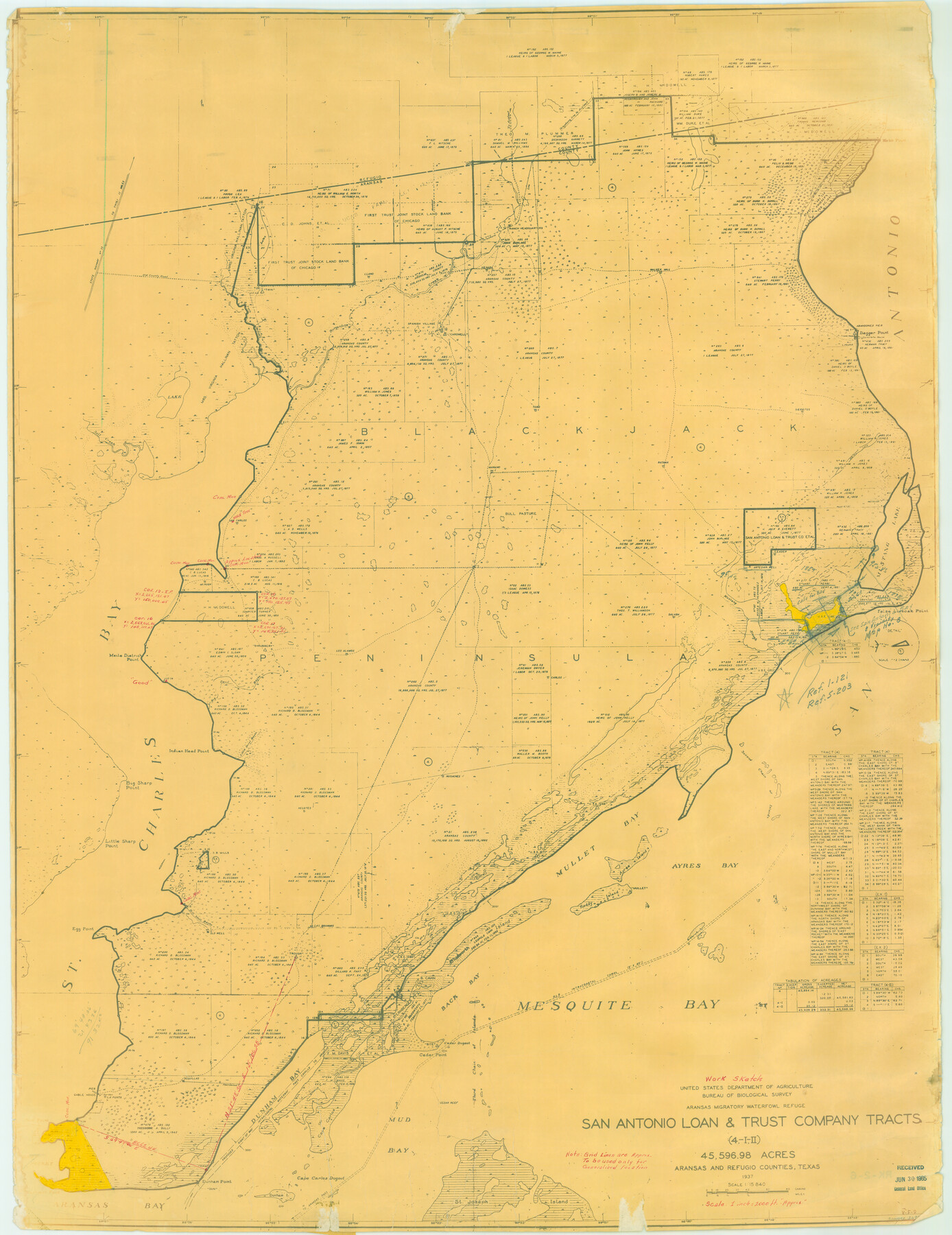
Aransas Migratory Waterfowl Refuge in Aransas and Refugio Counties
-
Map/Doc
2693
-
Collection
General Map Collection
-
Object Dates
1937 (Creation Date)
-
People and Organizations
U.S. Dept. of Agriculture (Author)
-
Counties
Aransas Refugio
-
Subjects
Gulf of Mexico
-
Height x Width
40.3 x 31.0 inches
102.4 x 78.7 cm
-
Medium
blueline
-
Scale
:15,840
-
Comments
National Ocean Survey map.
Part of: General Map Collection
Matagorda Light to Aransas Pass

Print $20.00
- Digital $50.00
Matagorda Light to Aransas Pass
1924
Size 35.9 x 44.6 inches
Map/Doc 73391
Young County Sketch File 16

Print $4.00
- Digital $50.00
Young County Sketch File 16
1896
Size 10.3 x 8.5 inches
Map/Doc 40880
Milam County Working Sketch 11

Print $20.00
- Digital $50.00
Milam County Working Sketch 11
1987
Size 43.8 x 31.9 inches
Map/Doc 71026
Map of Wharton County

Print $20.00
- Digital $50.00
Map of Wharton County
1865
Size 24.9 x 26.9 inches
Map/Doc 4136
[The S.K. Ry. of Texas, State Line to Pecos, Reeves Co., Texas]
![64161, [The S.K. Ry. of Texas, State Line to Pecos, Reeves Co., Texas], General Map Collection](https://historictexasmaps.com/wmedia_w700/maps/64161.tif.jpg)
Print $40.00
- Digital $50.00
[The S.K. Ry. of Texas, State Line to Pecos, Reeves Co., Texas]
1910
Size 19.2 x 120.9 inches
Map/Doc 64161
Flight Mission No. BRA-16M, Frame 170, Jefferson County

Print $20.00
- Digital $50.00
Flight Mission No. BRA-16M, Frame 170, Jefferson County
1953
Size 18.6 x 22.4 inches
Map/Doc 85768
Flight Mission No. DCL-6C, Frame 132, Kenedy County

Print $20.00
- Digital $50.00
Flight Mission No. DCL-6C, Frame 132, Kenedy County
1943
Size 18.6 x 22.3 inches
Map/Doc 85962
Crane County Rolled Sketch 14

Print $46.00
- Digital $50.00
Crane County Rolled Sketch 14
1935
Size 37.1 x 31.6 inches
Map/Doc 8680
Brewster County Sketch File B

Print $40.00
- Digital $50.00
Brewster County Sketch File B
1910
Size 25.5 x 18.3 inches
Map/Doc 10975
Starr County Rolled Sketch 35

Print $20.00
- Digital $50.00
Starr County Rolled Sketch 35
1925
Size 40.1 x 12.8 inches
Map/Doc 7832
Stieler Map of 1879

Print $4.00
- Digital $50.00
Stieler Map of 1879
1879
Size 28.8 x 23.0 inches
Map/Doc 76056
Refugio County Sketch File 20

Print $8.00
- Digital $50.00
Refugio County Sketch File 20
Size 14.4 x 8.8 inches
Map/Doc 35276
You may also like
Real County Working Sketch 90

Print $20.00
- Digital $50.00
Real County Working Sketch 90
1991
Size 16.7 x 22.8 inches
Map/Doc 71982
Hunt County Rolled Sketch 5

Print $20.00
- Digital $50.00
Hunt County Rolled Sketch 5
1956
Size 27.6 x 24.8 inches
Map/Doc 6270
Kimble County Sketch File 3

Print $4.00
- Digital $50.00
Kimble County Sketch File 3
1847
Size 9.1 x 11.5 inches
Map/Doc 28910
Stonewall County Sketch File 29

Print $4.00
- Digital $50.00
Stonewall County Sketch File 29
1976
Size 11.3 x 8.5 inches
Map/Doc 37306

Harris County Sketch File 31

Print $6.00
- Digital $50.00
Harris County Sketch File 31
Size 14.0 x 8.9 inches
Map/Doc 25426
Wood County Working Sketch 2

Print $20.00
- Digital $50.00
Wood County Working Sketch 2
1913
Size 17.8 x 16.8 inches
Map/Doc 62002
La Salle County Rolled Sketch 14

Print $20.00
- Digital $50.00
La Salle County Rolled Sketch 14
Size 22.3 x 24.8 inches
Map/Doc 6577
General Highway Map, Val Verde County, Texas

Print $20.00
General Highway Map, Val Verde County, Texas
1961
Size 24.9 x 18.1 inches
Map/Doc 79694
Sketch in Southeastern Portion of Stephens County

Print $20.00
- Digital $50.00
Sketch in Southeastern Portion of Stephens County
1919
Size 29.0 x 21.7 inches
Map/Doc 91841
Harbor Pass and Bar at Brazos Santiago, Texas

Print $20.00
- Digital $50.00
Harbor Pass and Bar at Brazos Santiago, Texas
1871
Size 18.3 x 27.4 inches
Map/Doc 73036
Hardin County Sketch File 45

Print $2.00
- Digital $50.00
Hardin County Sketch File 45
Size 8.3 x 6.2 inches
Map/Doc 25195