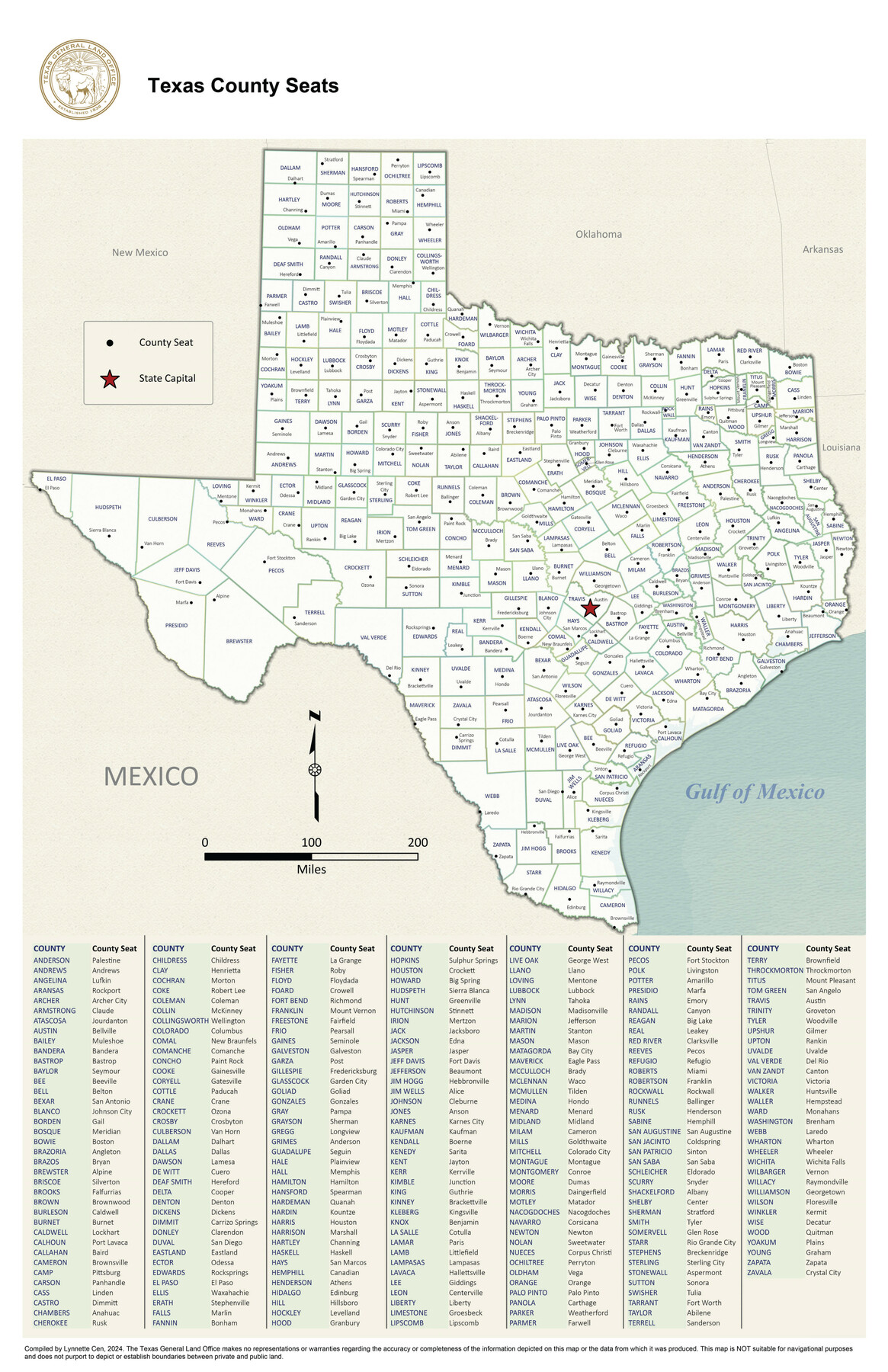
Texas County Seats
-
Map/Doc
97243
-
Collection
GIS Educational Maps
-
Object Dates
2024 (Creation Date)
-
People and Organizations
Lynnette Cen (Compiler)
-
Subjects
State of Texas Geographic Information System
-
Height x Width
17.0 x 11.0 inches
43.2 x 27.9 cm
-
Medium
pdf
-
Comments
See 97242 (8.5" x 11") and 97244 (28" x 36.2") for different sized versions of this map.
Related maps


Part of: GIS Educational Maps
Yellow Fever Deaths in the United States

Yellow Fever Deaths in the United States
2022
Size 8.5 x 11.0 inches
Map/Doc 97093

Aerial View of San Antonio de Béxar and Alamo Fortifications

Aerial View of San Antonio de Béxar and Alamo Fortifications
2026
Size 11.0 x 17.0 inches
Map/Doc 97522
United States Population Distribution by County and Territory, per the U.S. Census of 1890

United States Population Distribution by County and Territory, per the U.S. Census of 1890
2025
Size 8.5 x 11.0 inches
Map/Doc 97480
Explorations of the Louisiana Purchase

Explorations of the Louisiana Purchase
2023
Size 8.5 x 11.0 inches
Map/Doc 97183
Disputed Territory Between Mexico and the United States

Disputed Territory Between Mexico and the United States
2024
Size 10.7 x 7.9 inches
Map/Doc 97251
Republic of Texas and State of Louisiana Boundary

Republic of Texas and State of Louisiana Boundary
2022
Size 8.5 x 11.0 inches
Map/Doc 96979
General Range of Indigenous Tribes and Language Families in Texas

General Range of Indigenous Tribes and Language Families in Texas
2022
Size 8.5 x 11.0 inches
Map/Doc 97100
United States Population Distribution by County and Territory, per the U.S. Census of 1870

United States Population Distribution by County and Territory, per the U.S. Census of 1870
2025
Size 8.5 x 11.0 inches
Map/Doc 97479

The Dust Bowl: Severe Drought During the Depression

The Dust Bowl: Severe Drought During the Depression
2022
Size 8.5 x 11.0 inches
Map/Doc 97095

You may also like
Real County Working Sketch 26

Print $20.00
- Digital $50.00
Real County Working Sketch 26
1947
Size 28.7 x 28.1 inches
Map/Doc 71918
Hunt County Boundary File 49

Print $44.00
- Digital $50.00
Hunt County Boundary File 49
Size 9.1 x 5.2 inches
Map/Doc 55279
The Scarborough Company's New Railroad, Post Office & County Map of Texas, Oklahoma and Indian Territory Compiled from the Latest Government Surveys and Original Sources

Print $20.00
The Scarborough Company's New Railroad, Post Office & County Map of Texas, Oklahoma and Indian Territory Compiled from the Latest Government Surveys and Original Sources
1904
Size 43.1 x 47.8 inches
Map/Doc 93967
Geological map of Texas showing approximate locations and drilling wells. Also names of companies drilling

Print $20.00
- Digital $50.00
Geological map of Texas showing approximate locations and drilling wells. Also names of companies drilling
1920
Size 26.9 x 26.6 inches
Map/Doc 93937
King County Boundary File 5b

Print $25.00
- Digital $50.00
King County Boundary File 5b
Size 8.7 x 6.9 inches
Map/Doc 64924
Hemphill County Rolled Sketch 12

Print $20.00
- Digital $50.00
Hemphill County Rolled Sketch 12
1941
Size 36.0 x 45.1 inches
Map/Doc 9154
Tarrant County Working Sketch 27

Print $20.00
- Digital $50.00
Tarrant County Working Sketch 27
2010
Size 19.4 x 35.9 inches
Map/Doc 89261
Angelina County Sketch File 16a

Print $62.00
- Digital $50.00
Angelina County Sketch File 16a
1862
Size 6.0 x 8.3 inches
Map/Doc 13009
General Highway Map, Nolan County, Texas

Print $20.00
General Highway Map, Nolan County, Texas
1940
Size 18.4 x 24.7 inches
Map/Doc 79208
Wise County Sketch File 2a

Print $4.00
- Digital $50.00
Wise County Sketch File 2a
1856
Size 12.3 x 8.1 inches
Map/Doc 40526
Culberson County Working Sketch 34

Print $20.00
- Digital $50.00
Culberson County Working Sketch 34
1962
Size 35.2 x 26.0 inches
Map/Doc 68487
