A Map of that part of Young District south of old Fannin District line

Print $20.00
- Digital $50.00
A Map of that part of Young District south of old Fannin District line
1861
Size: 24.9 x 38.0 inches
1979
Bird's Eye View of Abilene, Taylor County, Texas

Print $20.00
Bird's Eye View of Abilene, Taylor County, Texas
1883
Size: 23.6 x 30.7 inches
89071
Callahan County Sketch File 1

Print $4.00
- Digital $50.00
Callahan County Sketch File 1
Size: 9.1 x 8.2 inches
35851
Callahan County Sketch File 11

Print $64.00
- Digital $50.00
Callahan County Sketch File 11
Size: 11.4 x 8.4 inches
35887
Callahan County Sketch File 6a

Print $24.00
- Digital $50.00
Callahan County Sketch File 6a
Size: 8.0 x 6.8 inches
35860
General Highway Map, Taylor County, Texas

Print $20.00
General Highway Map, Taylor County, Texas
1940
Size: 18.6 x 25.0 inches
79254
General Highway Map, Taylor County, Texas

Print $20.00
General Highway Map, Taylor County, Texas
1961
Size: 18.2 x 24.8 inches
79672
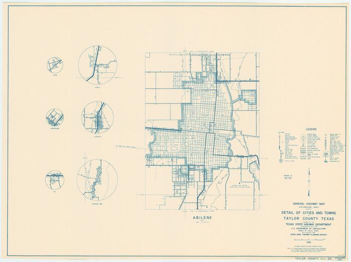
General Highway Map. Detail of Cities and Towns in Taylor County, Texas [Abilene and vicinity]
Print $20.00
General Highway Map. Detail of Cities and Towns in Taylor County, Texas [Abilene and vicinity]
1961
Size: 18.2 x 24.8 inches
79673
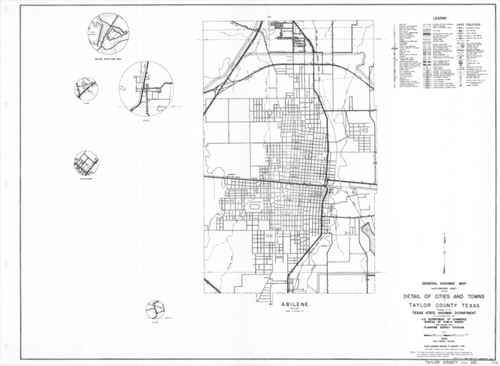
General Highway Map. Detail of Cities and Towns in Taylor County, Texas [Abilene and vicinity]
Print $20.00
General Highway Map. Detail of Cities and Towns in Taylor County, Texas [Abilene and vicinity]
1940
Size: 18.5 x 24.9 inches
79255
Jones County Boundary File 1b

Print $40.00
- Digital $50.00
Jones County Boundary File 1b
1882
Size: 37.5 x 12.6 inches
44359
Jones County Sketch File 10a

Print $40.00
- Digital $50.00
Jones County Sketch File 10a
1875
Size: 40.0 x 50.6 inches
10509
Jones County Sketch File 11a

Print $40.00
- Digital $50.00
Jones County Sketch File 11a
Size: 37.5 x 49.5 inches
10510
Jones County Sketch File 3

Print $4.00
- Digital $50.00
Jones County Sketch File 3
1854
Size: 13.3 x 8.0 inches
28488
Map of Asylum Lands

Print $20.00
- Digital $50.00
Map of Asylum Lands
1857
Size: 28.4 x 18.5 inches
2459
Map of Taylor County

Print $20.00
- Digital $50.00
Map of Taylor County
1858
Size: 24.0 x 25.3 inches
4070
Map of Taylor County Travis- Young- Bexar- Land District

Print $20.00
- Digital $50.00
Map of Taylor County Travis- Young- Bexar- Land District
1859
Size: 25.1 x 20.4 inches
4071
Map of the Texas & Pacific Railway from Fort Worth to El Paso

Print $40.00
- Digital $50.00
Map of the Texas & Pacific Railway from Fort Worth to El Paso
Size: 24.0 x 76.5 inches
64511
Nolan County Rolled Sketch W

Print $20.00
- Digital $50.00
Nolan County Rolled Sketch W
1902
Size: 16.5 x 38.0 inches
6863
Nolan County Sketch File 1

Print $48.00
- Digital $50.00
Nolan County Sketch File 1
1890
Size: 14.1 x 8.5 inches
32470
Nolan County Sketch File 11

Print $20.00
- Digital $50.00
Nolan County Sketch File 11
1902
Size: 18.5 x 37.5 inches
42162
Nolan County Sketch File 17

Print $6.00
- Digital $50.00
Nolan County Sketch File 17
1940
Size: 17.9 x 10.1 inches
32487
Nolan County Sketch File 8

Print $2.00
- Digital $50.00
Nolan County Sketch File 8
Size: 11.3 x 8.8 inches
32464
Nolan County Sketch File 9

Print $26.00
- Digital $50.00
Nolan County Sketch File 9
1902
Size: 14.3 x 9.0 inches
32465
Nolan County Sketch File C

Print $20.00
- Digital $50.00
Nolan County Sketch File C
1902
Size: 14.4 x 31.5 inches
42172
Nolan County Sketch File D1

Print $42.00
- Digital $50.00
Nolan County Sketch File D1
1904
Size: 19.5 x 18.8 inches
42173
Nolan County, Texas

Print $20.00
- Digital $50.00
Nolan County, Texas
1880
Size: 29.5 x 22.7 inches
588
Reconnaissance Map, Roby Sheet

Print $20.00
- Digital $50.00
Reconnaissance Map, Roby Sheet
1893
Size: 17.0 x 20.8 inches
90869
Runnels County Rolled Sketch 18

Print $20.00
- Digital $50.00
Runnels County Rolled Sketch 18
Size: 23.1 x 25.3 inches
7513
Runnels County Rolled Sketch 44

Print $40.00
- Digital $50.00
Runnels County Rolled Sketch 44
Size: 43.0 x 53.9 inches
9871
A Map of that part of Young District south of old Fannin District line
Print $20.00
- Digital $50.00
A Map of that part of Young District south of old Fannin District line
1861
-
Size
24.9 x 38.0 inches
-
Map/Doc
1979
-
Creation Date
1861
Bird's Eye View of Abilene, Taylor County, Texas
Print $20.00
Bird's Eye View of Abilene, Taylor County, Texas
1883
-
Size
23.6 x 30.7 inches
-
Map/Doc
89071
-
Creation Date
1883
Callahan County Sketch File 1
Print $4.00
- Digital $50.00
Callahan County Sketch File 1
-
Size
9.1 x 8.2 inches
-
Map/Doc
35851
Callahan County Sketch File 11
Print $64.00
- Digital $50.00
Callahan County Sketch File 11
-
Size
11.4 x 8.4 inches
-
Map/Doc
35887
Callahan County Sketch File 6a
Print $24.00
- Digital $50.00
Callahan County Sketch File 6a
-
Size
8.0 x 6.8 inches
-
Map/Doc
35860
General Highway Map, Taylor County, Texas
Print $20.00
General Highway Map, Taylor County, Texas
1940
-
Size
18.6 x 25.0 inches
-
Map/Doc
79254
-
Creation Date
1940
General Highway Map, Taylor County, Texas
Print $20.00
General Highway Map, Taylor County, Texas
1961
-
Size
18.2 x 24.8 inches
-
Map/Doc
79672
-
Creation Date
1961
General Highway Map. Detail of Cities and Towns in Taylor County, Texas [Abilene and vicinity]
Print $20.00
General Highway Map. Detail of Cities and Towns in Taylor County, Texas [Abilene and vicinity]
1961
-
Size
18.2 x 24.8 inches
-
Map/Doc
79673
-
Creation Date
1961
General Highway Map. Detail of Cities and Towns in Taylor County, Texas [Abilene and vicinity]
Print $20.00
General Highway Map. Detail of Cities and Towns in Taylor County, Texas [Abilene and vicinity]
1940
-
Size
18.5 x 24.9 inches
-
Map/Doc
79255
-
Creation Date
1940
Jones County Boundary File 1b
Print $40.00
- Digital $50.00
Jones County Boundary File 1b
1882
-
Size
37.5 x 12.6 inches
-
Map/Doc
44359
-
Creation Date
1882
Jones County Sketch File 10a
Print $40.00
- Digital $50.00
Jones County Sketch File 10a
1875
-
Size
40.0 x 50.6 inches
-
Map/Doc
10509
-
Creation Date
1875
Jones County Sketch File 11a
Print $40.00
- Digital $50.00
Jones County Sketch File 11a
-
Size
37.5 x 49.5 inches
-
Map/Doc
10510
Jones County Sketch File 3
Print $4.00
- Digital $50.00
Jones County Sketch File 3
1854
-
Size
13.3 x 8.0 inches
-
Map/Doc
28488
-
Creation Date
1854
Map of Abilene

Print $20.00
- Digital $50.00
Map of Abilene
1885
-
Size
24.6 x 27.4 inches
-
Map/Doc
3042
-
Creation Date
1885
Map of Asylum Lands
Print $20.00
- Digital $50.00
Map of Asylum Lands
1857
-
Size
28.4 x 18.5 inches
-
Map/Doc
2459
-
Creation Date
1857
Map of Taylor County
Print $20.00
- Digital $50.00
Map of Taylor County
1858
-
Size
24.0 x 25.3 inches
-
Map/Doc
4070
-
Creation Date
1858
Map of Taylor County Travis- Young- Bexar- Land District
Print $20.00
- Digital $50.00
Map of Taylor County Travis- Young- Bexar- Land District
1859
-
Size
25.1 x 20.4 inches
-
Map/Doc
4071
-
Creation Date
1859
Map of the Texas & Pacific Railway from Fort Worth to El Paso
Print $40.00
- Digital $50.00
Map of the Texas & Pacific Railway from Fort Worth to El Paso
-
Size
24.0 x 76.5 inches
-
Map/Doc
64511
Nolan County Rolled Sketch W
Print $20.00
- Digital $50.00
Nolan County Rolled Sketch W
1902
-
Size
16.5 x 38.0 inches
-
Map/Doc
6863
-
Creation Date
1902
Nolan County Sketch File 1
Print $48.00
- Digital $50.00
Nolan County Sketch File 1
1890
-
Size
14.1 x 8.5 inches
-
Map/Doc
32470
-
Creation Date
1890
Nolan County Sketch File 11
Print $20.00
- Digital $50.00
Nolan County Sketch File 11
1902
-
Size
18.5 x 37.5 inches
-
Map/Doc
42162
-
Creation Date
1902
Nolan County Sketch File 17
Print $6.00
- Digital $50.00
Nolan County Sketch File 17
1940
-
Size
17.9 x 10.1 inches
-
Map/Doc
32487
-
Creation Date
1940
Nolan County Sketch File 8
Print $2.00
- Digital $50.00
Nolan County Sketch File 8
-
Size
11.3 x 8.8 inches
-
Map/Doc
32464
Nolan County Sketch File 9
Print $26.00
- Digital $50.00
Nolan County Sketch File 9
1902
-
Size
14.3 x 9.0 inches
-
Map/Doc
32465
-
Creation Date
1902
Nolan County Sketch File C
Print $20.00
- Digital $50.00
Nolan County Sketch File C
1902
-
Size
14.4 x 31.5 inches
-
Map/Doc
42172
-
Creation Date
1902
Nolan County Sketch File D1
Print $42.00
- Digital $50.00
Nolan County Sketch File D1
1904
-
Size
19.5 x 18.8 inches
-
Map/Doc
42173
-
Creation Date
1904
Nolan County, Texas
Print $20.00
- Digital $50.00
Nolan County, Texas
1880
-
Size
29.5 x 22.7 inches
-
Map/Doc
588
-
Creation Date
1880
Reconnaissance Map, Roby Sheet
Print $20.00
- Digital $50.00
Reconnaissance Map, Roby Sheet
1893
-
Size
17.0 x 20.8 inches
-
Map/Doc
90869
-
Creation Date
1893
Runnels County Rolled Sketch 18
Print $20.00
- Digital $50.00
Runnels County Rolled Sketch 18
-
Size
23.1 x 25.3 inches
-
Map/Doc
7513
Runnels County Rolled Sketch 44
Print $40.00
- Digital $50.00
Runnels County Rolled Sketch 44
-
Size
43.0 x 53.9 inches
-
Map/Doc
9871