[Texas & Pacific Railway through Callahan County]
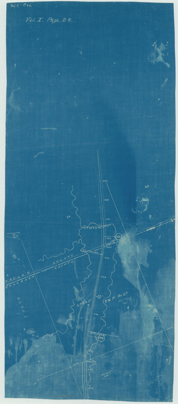
Print $20.00
- Digital $50.00
[Texas & Pacific Railway through Callahan County]
1918
Size: 21.1 x 9.3 inches
64239
[Surveying sketch of Jones County showing Micaela Fiagoso survey]
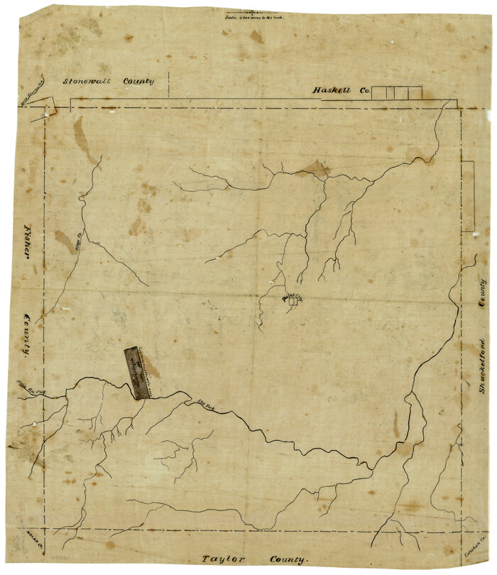
Print $20.00
- Digital $50.00
[Surveying sketch of Jones County showing Micaela Fiagoso survey]
Size: 19.5 x 16.8 inches
387
[Sketch of expeditions, trails in Jones, Taylor, Shackelford, Callahan, Buchanan/Stephens and Eastland Counties]
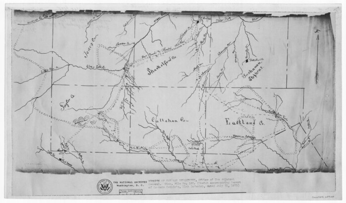
Print $4.00
- Digital $50.00
[Sketch of expeditions, trails in Jones, Taylor, Shackelford, Callahan, Buchanan/Stephens and Eastland Counties]
1873
Size: 10.8 x 18.3 inches
65405
[Sketch of expeditions, trails in Jones, Taylor, Shackelford, Callahan, Buchanan/Stephens and Eastland Counties]
Print $4.00
- Digital $50.00
[Sketch of expeditions, trails in Jones, Taylor, Shackelford, Callahan, Buchanan/Stephens and Eastland Counties]
1873
Size: 10.7 x 18.1 inches
65406
[Map of a portion of Bexar and Travis Districts]
Print $20.00
- Digital $50.00
[Map of a portion of Bexar and Travis Districts]
Size: 47.5 x 47.2 inches
16943
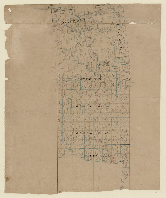
[Map of Texas and Pacific Blocks from Brazos River westward through Palo Pinto, Stephens, Shackelford, Jones, Callahan, Taylor, Fisher, Nolan and Mitchell Counties]
Print $20.00
- Digital $50.00
[Map of Texas and Pacific Blocks from Brazos River westward through Palo Pinto, Stephens, Shackelford, Jones, Callahan, Taylor, Fisher, Nolan and Mitchell Counties]
Size: 22.0 x 18.5 inches
93456
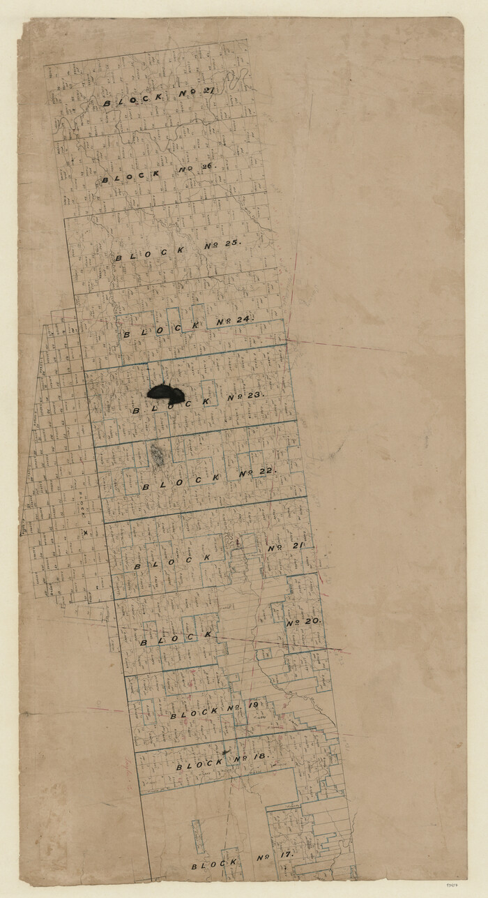
[Map of Texas and Pacific Blocks from Brazos River westward through Palo Pinto, Stephens, Shackelford, Jones, Callahan, Taylor, Fisher, Nolan and Mitchell Counties]
Print $20.00
- Digital $50.00
[Map of Texas and Pacific Blocks from Brazos River westward through Palo Pinto, Stephens, Shackelford, Jones, Callahan, Taylor, Fisher, Nolan and Mitchell Counties]
Size: 35.0 x 19.3 inches
93457
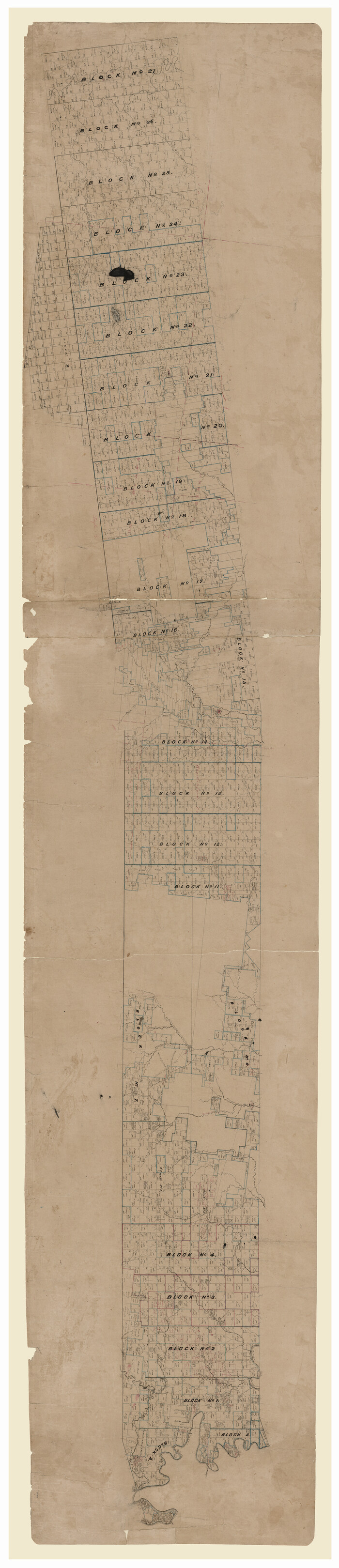
[Map of Texas and Pacific Blocks from Brazos River westward through Palo Pinto, Stephens, Shackelford, Jones, Callahan, Taylor, Fisher, Nolan and Mitchell Counties]
Print $40.00
- Digital $50.00
[Map of Texas and Pacific Blocks from Brazos River westward through Palo Pinto, Stephens, Shackelford, Jones, Callahan, Taylor, Fisher, Nolan and Mitchell Counties]
Size: 87.1 x 18.8 inches
93460
Water-Shed of the Colorado River

Print $40.00
- Digital $50.00
Water-Shed of the Colorado River
1925
Size: 37.1 x 79.8 inches
65261
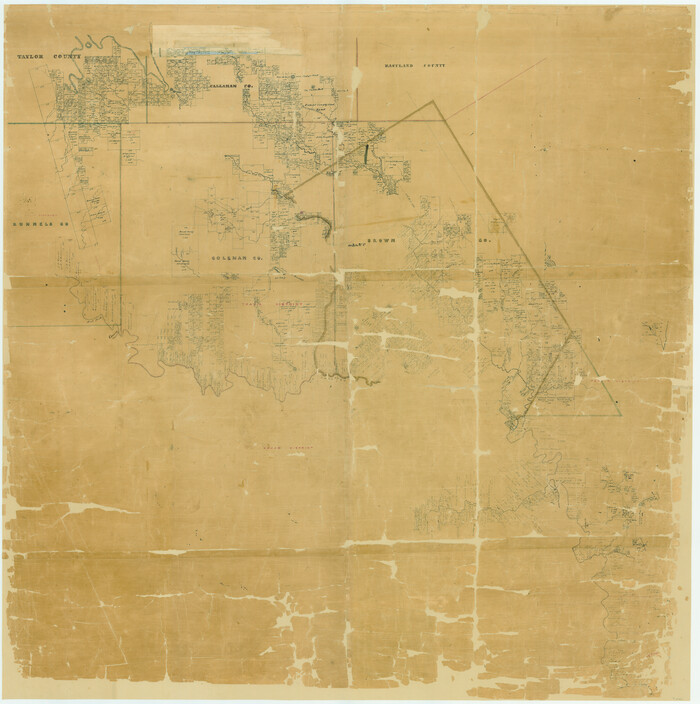
Taylor County, Texas

Print $20.00
- Digital $50.00
Taylor County, Texas
1890
Size: 28.7 x 21.6 inches
574
Taylor County Working Sketch Graphic Index

Print $20.00
- Digital $50.00
Taylor County Working Sketch Graphic Index
1934
Size: 42.8 x 36.4 inches
76709
Taylor County Working Sketch 9

Print $20.00
- Digital $50.00
Taylor County Working Sketch 9
1955
Size: 24.2 x 24.6 inches
69619
Taylor County Working Sketch 8

Print $40.00
- Digital $50.00
Taylor County Working Sketch 8
1953
Size: 73.2 x 43.1 inches
69618
Taylor County Working Sketch 7

Print $20.00
- Digital $50.00
Taylor County Working Sketch 7
1953
Size: 41.3 x 16.1 inches
69617
Taylor County Working Sketch 6

Print $20.00
- Digital $50.00
Taylor County Working Sketch 6
1951
Size: 35.4 x 31.9 inches
69616
Taylor County Working Sketch 5

Print $20.00
- Digital $50.00
Taylor County Working Sketch 5
1950
Size: 31.1 x 24.7 inches
69615
Taylor County Working Sketch 4b

Print $20.00
- Digital $50.00
Taylor County Working Sketch 4b
1944
Size: 17.0 x 14.2 inches
69614
Taylor County Working Sketch 4a

Print $20.00
- Digital $50.00
Taylor County Working Sketch 4a
1944
Size: 17.2 x 14.0 inches
69613
Taylor County Working Sketch 3

Print $20.00
- Digital $50.00
Taylor County Working Sketch 3
1939
Size: 15.2 x 19.2 inches
69612
Taylor County Working Sketch 22

Print $40.00
- Digital $50.00
Taylor County Working Sketch 22
1985
Size: 50.3 x 37.3 inches
69632
Taylor County Working Sketch 21

Print $40.00
- Digital $50.00
Taylor County Working Sketch 21
1985
Size: 55.9 x 43.8 inches
69631
Taylor County Working Sketch 20

Print $40.00
- Digital $50.00
Taylor County Working Sketch 20
1985
Size: 58.7 x 36.7 inches
69630
Taylor County Working Sketch 2

Print $20.00
- Digital $50.00
Taylor County Working Sketch 2
1930
Size: 27.3 x 23.1 inches
69611
Taylor County Working Sketch 19

Print $20.00
- Digital $50.00
Taylor County Working Sketch 19
1985
Size: 30.0 x 44.0 inches
69629
Taylor County Working Sketch 18

Print $20.00
- Digital $50.00
Taylor County Working Sketch 18
1985
Size: 43.2 x 46.0 inches
69628
Taylor County Working Sketch 17

Print $20.00
- Digital $50.00
Taylor County Working Sketch 17
1982
Size: 42.7 x 37.0 inches
69627
Taylor County Working Sketch 16

Print $20.00
- Digital $50.00
Taylor County Working Sketch 16
1981
Size: 28.8 x 41.2 inches
69626
Taylor County Working Sketch 15

Print $20.00
- Digital $50.00
Taylor County Working Sketch 15
1972
Size: 44.1 x 30.4 inches
69625
Taylor County Working Sketch 14

Print $20.00
- Digital $50.00
Taylor County Working Sketch 14
1959
Size: 26.8 x 21.4 inches
69624
Taylor County Working Sketch 13

Print $20.00
- Digital $50.00
Taylor County Working Sketch 13
1956
Size: 16.3 x 28.9 inches
69623
[Texas & Pacific Railway through Callahan County]
Print $20.00
- Digital $50.00
[Texas & Pacific Railway through Callahan County]
1918
-
Size
21.1 x 9.3 inches
-
Map/Doc
64239
-
Creation Date
1918
[Surveying sketch of Jones County showing Micaela Fiagoso survey]
Print $20.00
- Digital $50.00
[Surveying sketch of Jones County showing Micaela Fiagoso survey]
-
Size
19.5 x 16.8 inches
-
Map/Doc
387
[Sketch of expeditions, trails in Jones, Taylor, Shackelford, Callahan, Buchanan/Stephens and Eastland Counties]
Print $4.00
- Digital $50.00
[Sketch of expeditions, trails in Jones, Taylor, Shackelford, Callahan, Buchanan/Stephens and Eastland Counties]
1873
-
Size
10.8 x 18.3 inches
-
Map/Doc
65405
-
Creation Date
1873
[Sketch of expeditions, trails in Jones, Taylor, Shackelford, Callahan, Buchanan/Stephens and Eastland Counties]
Print $4.00
- Digital $50.00
[Sketch of expeditions, trails in Jones, Taylor, Shackelford, Callahan, Buchanan/Stephens and Eastland Counties]
1873
-
Size
10.7 x 18.1 inches
-
Map/Doc
65406
-
Creation Date
1873
[Map of a portion of Bexar and Travis Districts]
Print $20.00
- Digital $50.00
[Map of a portion of Bexar and Travis Districts]
-
Size
47.5 x 47.2 inches
-
Map/Doc
16943
[Map of Texas and Pacific Blocks from Brazos River westward through Palo Pinto, Stephens, Shackelford, Jones, Callahan, Taylor, Fisher, Nolan and Mitchell Counties]
Print $20.00
- Digital $50.00
[Map of Texas and Pacific Blocks from Brazos River westward through Palo Pinto, Stephens, Shackelford, Jones, Callahan, Taylor, Fisher, Nolan and Mitchell Counties]
-
Size
22.0 x 18.5 inches
-
Map/Doc
93456
[Map of Texas and Pacific Blocks from Brazos River westward through Palo Pinto, Stephens, Shackelford, Jones, Callahan, Taylor, Fisher, Nolan and Mitchell Counties]
Print $20.00
- Digital $50.00
[Map of Texas and Pacific Blocks from Brazos River westward through Palo Pinto, Stephens, Shackelford, Jones, Callahan, Taylor, Fisher, Nolan and Mitchell Counties]
-
Size
35.0 x 19.3 inches
-
Map/Doc
93457
[Map of Texas and Pacific Blocks from Brazos River westward through Palo Pinto, Stephens, Shackelford, Jones, Callahan, Taylor, Fisher, Nolan and Mitchell Counties]
Print $40.00
- Digital $50.00
[Map of Texas and Pacific Blocks from Brazos River westward through Palo Pinto, Stephens, Shackelford, Jones, Callahan, Taylor, Fisher, Nolan and Mitchell Counties]
-
Size
87.1 x 18.8 inches
-
Map/Doc
93460
Water-Shed of the Colorado River
Print $40.00
- Digital $50.00
Water-Shed of the Colorado River
1925
-
Size
37.1 x 79.8 inches
-
Map/Doc
65261
-
Creation Date
1925
Taylor County, Texas
Print $20.00
- Digital $50.00
Taylor County, Texas
1890
-
Size
28.7 x 21.6 inches
-
Map/Doc
574
-
Creation Date
1890
Taylor County Working Sketch Graphic Index
Print $20.00
- Digital $50.00
Taylor County Working Sketch Graphic Index
1934
-
Size
42.8 x 36.4 inches
-
Map/Doc
76709
-
Creation Date
1934
Taylor County Working Sketch 9
Print $20.00
- Digital $50.00
Taylor County Working Sketch 9
1955
-
Size
24.2 x 24.6 inches
-
Map/Doc
69619
-
Creation Date
1955
Taylor County Working Sketch 8
Print $40.00
- Digital $50.00
Taylor County Working Sketch 8
1953
-
Size
73.2 x 43.1 inches
-
Map/Doc
69618
-
Creation Date
1953
Taylor County Working Sketch 7
Print $20.00
- Digital $50.00
Taylor County Working Sketch 7
1953
-
Size
41.3 x 16.1 inches
-
Map/Doc
69617
-
Creation Date
1953
Taylor County Working Sketch 6
Print $20.00
- Digital $50.00
Taylor County Working Sketch 6
1951
-
Size
35.4 x 31.9 inches
-
Map/Doc
69616
-
Creation Date
1951
Taylor County Working Sketch 5
Print $20.00
- Digital $50.00
Taylor County Working Sketch 5
1950
-
Size
31.1 x 24.7 inches
-
Map/Doc
69615
-
Creation Date
1950
Taylor County Working Sketch 4b
Print $20.00
- Digital $50.00
Taylor County Working Sketch 4b
1944
-
Size
17.0 x 14.2 inches
-
Map/Doc
69614
-
Creation Date
1944
Taylor County Working Sketch 4a
Print $20.00
- Digital $50.00
Taylor County Working Sketch 4a
1944
-
Size
17.2 x 14.0 inches
-
Map/Doc
69613
-
Creation Date
1944
Taylor County Working Sketch 3
Print $20.00
- Digital $50.00
Taylor County Working Sketch 3
1939
-
Size
15.2 x 19.2 inches
-
Map/Doc
69612
-
Creation Date
1939
Taylor County Working Sketch 22
Print $40.00
- Digital $50.00
Taylor County Working Sketch 22
1985
-
Size
50.3 x 37.3 inches
-
Map/Doc
69632
-
Creation Date
1985
Taylor County Working Sketch 21
Print $40.00
- Digital $50.00
Taylor County Working Sketch 21
1985
-
Size
55.9 x 43.8 inches
-
Map/Doc
69631
-
Creation Date
1985
Taylor County Working Sketch 20
Print $40.00
- Digital $50.00
Taylor County Working Sketch 20
1985
-
Size
58.7 x 36.7 inches
-
Map/Doc
69630
-
Creation Date
1985
Taylor County Working Sketch 2
Print $20.00
- Digital $50.00
Taylor County Working Sketch 2
1930
-
Size
27.3 x 23.1 inches
-
Map/Doc
69611
-
Creation Date
1930
Taylor County Working Sketch 19
Print $20.00
- Digital $50.00
Taylor County Working Sketch 19
1985
-
Size
30.0 x 44.0 inches
-
Map/Doc
69629
-
Creation Date
1985
Taylor County Working Sketch 18
Print $20.00
- Digital $50.00
Taylor County Working Sketch 18
1985
-
Size
43.2 x 46.0 inches
-
Map/Doc
69628
-
Creation Date
1985
Taylor County Working Sketch 17
Print $20.00
- Digital $50.00
Taylor County Working Sketch 17
1982
-
Size
42.7 x 37.0 inches
-
Map/Doc
69627
-
Creation Date
1982
Taylor County Working Sketch 16
Print $20.00
- Digital $50.00
Taylor County Working Sketch 16
1981
-
Size
28.8 x 41.2 inches
-
Map/Doc
69626
-
Creation Date
1981
Taylor County Working Sketch 15
Print $20.00
- Digital $50.00
Taylor County Working Sketch 15
1972
-
Size
44.1 x 30.4 inches
-
Map/Doc
69625
-
Creation Date
1972
Taylor County Working Sketch 14
Print $20.00
- Digital $50.00
Taylor County Working Sketch 14
1959
-
Size
26.8 x 21.4 inches
-
Map/Doc
69624
-
Creation Date
1959
Taylor County Working Sketch 13
Print $20.00
- Digital $50.00
Taylor County Working Sketch 13
1956
-
Size
16.3 x 28.9 inches
-
Map/Doc
69623
-
Creation Date
1956