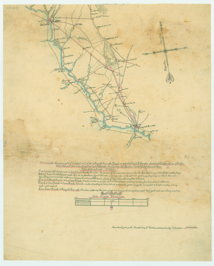
Best Route for Movements of Troops from Laredo to Ringold [sic] Barracks, Texas
Print $20.00
Best Route for Movements of Troops from Laredo to Ringold [sic] Barracks, Texas
1865
Size: 18.9 x 15.3 inches
79299
Description of Best Route from San Antonio to Laredo, Texas

Print $20.00
Description of Best Route from San Antonio to Laredo, Texas
1865
Size: 28.6 x 13.7 inches
79302
Dimmit County Rolled Sketch 16

Print $40.00
- Digital $50.00
Dimmit County Rolled Sketch 16
1964
Size: 30.5 x 48.3 inches
8798
Dimmit County Rolled Sketch 2

Print $20.00
- Digital $50.00
Dimmit County Rolled Sketch 2
Size: 33.9 x 39.6 inches
8793
Dimmit County Rolled Sketch 22

Print $20.00
- Digital $50.00
Dimmit County Rolled Sketch 22
2012
Size: 31.5 x 24.0 inches
93629
Dimmit County Rolled Sketch 22A

Print $20.00
- Digital $50.00
Dimmit County Rolled Sketch 22A
2012
Size: 23.2 x 34.0 inches
93630
Dimmit County Rolled Sketch 9

Print $20.00
- Digital $50.00
Dimmit County Rolled Sketch 9
1941
Size: 37.8 x 39.3 inches
8796
Dimmit County Sketch File 10

Print $20.00
- Digital $50.00
Dimmit County Sketch File 10
Size: 23.5 x 22.6 inches
11338
Dimmit County Sketch File 29

Print $40.00
- Digital $50.00
Dimmit County Sketch File 29
1877
Size: 26.5 x 22.1 inches
11351
Dimmit County Sketch File 44

Print $20.00
- Digital $50.00
Dimmit County Sketch File 44
Size: 16.3 x 19.5 inches
11354
Dimmit County Sketch File 62

Print $8.00
- Digital $50.00
Dimmit County Sketch File 62
2012
Size: 11.0 x 8.5 inches
93631
Dimmit County Sketch File 9

Print $6.00
- Digital $50.00
Dimmit County Sketch File 9
Size: 8.9 x 11.2 inches
21070
Dimmit County Working Sketch 22

Print $20.00
- Digital $50.00
Dimmit County Working Sketch 22
1951
Size: 37.3 x 38.7 inches
68683
Dimmit County Working Sketch 38

Print $40.00
- Digital $50.00
Dimmit County Working Sketch 38
1966
Size: 59.4 x 43.0 inches
68699
Duval County Rolled Sketch 33A

Print $40.00
- Digital $50.00
Duval County Rolled Sketch 33A
1949
Size: 43.8 x 79.5 inches
8818
Duval County Rolled Sketch 33B

Print $40.00
- Digital $50.00
Duval County Rolled Sketch 33B
1949
Size: 42.5 x 76.2 inches
8819
Duval County Rolled Sketch 5

Print $20.00
- Digital $50.00
Duval County Rolled Sketch 5
1929
Size: 23.0 x 16.8 inches
5732
Duval County Sketch File 45a

Print $9.00
- Digital $50.00
Duval County Sketch File 45a
Size: 14.5 x 9.0 inches
21396
Duval County Sketch File 79

Print $46.00
- Digital $50.00
Duval County Sketch File 79
1925
Size: 14.3 x 9.1 inches
21469
Duval County Sketch File 83

Print $20.00
- Digital $50.00
Duval County Sketch File 83
1933
Size: 13.7 x 8.8 inches
21521
Duval County Working Sketch 30

Print $20.00
- Digital $50.00
Duval County Working Sketch 30
1950
Size: 29.1 x 33.5 inches
68754
Duval County Working Sketch 50

Print $20.00
- Digital $50.00
Duval County Working Sketch 50
1984
Size: 38.0 x 32.0 inches
68774
Duval County Working Sketch 55

Print $20.00
- Digital $50.00
Duval County Working Sketch 55
1936
Size: 25.7 x 21.6 inches
68779
General Highway Map, Webb County, Texas

Print $20.00
General Highway Map, Webb County, Texas
1940
Size: 18.2 x 24.9 inches
79273
General Highway Map, Webb County, Texas

Print $20.00
General Highway Map, Webb County, Texas
1961
Size: 18.2 x 24.8 inches
79704
General Highway Map. Detail of Cities and Towns in Webb County, Texas [Laredo and vicinity]

Print $20.00
General Highway Map. Detail of Cities and Towns in Webb County, Texas [Laredo and vicinity]
1961
Size: 24.8 x 18.1 inches
79705
General Road Map, Webb County, Texas

Print $40.00
- Digital $50.00
General Road Map, Webb County, Texas
1944
Size: 37.1 x 50.0 inches
10126
Jim Hogg County Rolled Sketch 4

Print $20.00
- Digital $50.00
Jim Hogg County Rolled Sketch 4
Size: 17.0 x 30.5 inches
6440
Jim Hogg County Rolled Sketch 6

Print $40.00
- Digital $50.00
Jim Hogg County Rolled Sketch 6
1943
Size: 51.9 x 38.4 inches
9322
La Salle County Rolled Sketch 2

Print $20.00
- Digital $50.00
La Salle County Rolled Sketch 2
1915
Size: 25.2 x 23.2 inches
6567
Best Route for Movements of Troops from Laredo to Ringold [sic] Barracks, Texas
Print $20.00
Best Route for Movements of Troops from Laredo to Ringold [sic] Barracks, Texas
1865
-
Size
18.9 x 15.3 inches
-
Map/Doc
79299
-
Creation Date
1865
Description of Best Route from San Antonio to Laredo, Texas
Print $20.00
Description of Best Route from San Antonio to Laredo, Texas
1865
-
Size
28.6 x 13.7 inches
-
Map/Doc
79302
-
Creation Date
1865
Dimmit County Rolled Sketch 16
Print $40.00
- Digital $50.00
Dimmit County Rolled Sketch 16
1964
-
Size
30.5 x 48.3 inches
-
Map/Doc
8798
-
Creation Date
1964
Dimmit County Rolled Sketch 2
Print $20.00
- Digital $50.00
Dimmit County Rolled Sketch 2
-
Size
33.9 x 39.6 inches
-
Map/Doc
8793
Dimmit County Rolled Sketch 22
Print $20.00
- Digital $50.00
Dimmit County Rolled Sketch 22
2012
-
Size
31.5 x 24.0 inches
-
Map/Doc
93629
-
Creation Date
2012
Dimmit County Rolled Sketch 22A
Print $20.00
- Digital $50.00
Dimmit County Rolled Sketch 22A
2012
-
Size
23.2 x 34.0 inches
-
Map/Doc
93630
-
Creation Date
2012
Dimmit County Rolled Sketch 9
Print $20.00
- Digital $50.00
Dimmit County Rolled Sketch 9
1941
-
Size
37.8 x 39.3 inches
-
Map/Doc
8796
-
Creation Date
1941
Dimmit County Sketch File 10
Print $20.00
- Digital $50.00
Dimmit County Sketch File 10
-
Size
23.5 x 22.6 inches
-
Map/Doc
11338
Dimmit County Sketch File 29
Print $40.00
- Digital $50.00
Dimmit County Sketch File 29
1877
-
Size
26.5 x 22.1 inches
-
Map/Doc
11351
-
Creation Date
1877
Dimmit County Sketch File 44
Print $20.00
- Digital $50.00
Dimmit County Sketch File 44
-
Size
16.3 x 19.5 inches
-
Map/Doc
11354
Dimmit County Sketch File 62
Print $8.00
- Digital $50.00
Dimmit County Sketch File 62
2012
-
Size
11.0 x 8.5 inches
-
Map/Doc
93631
-
Creation Date
2012
Dimmit County Sketch File 9
Print $6.00
- Digital $50.00
Dimmit County Sketch File 9
-
Size
8.9 x 11.2 inches
-
Map/Doc
21070
Dimmit County Working Sketch 22
Print $20.00
- Digital $50.00
Dimmit County Working Sketch 22
1951
-
Size
37.3 x 38.7 inches
-
Map/Doc
68683
-
Creation Date
1951
Dimmit County Working Sketch 38
Print $40.00
- Digital $50.00
Dimmit County Working Sketch 38
1966
-
Size
59.4 x 43.0 inches
-
Map/Doc
68699
-
Creation Date
1966
Duval County Rolled Sketch 33A
Print $40.00
- Digital $50.00
Duval County Rolled Sketch 33A
1949
-
Size
43.8 x 79.5 inches
-
Map/Doc
8818
-
Creation Date
1949
Duval County Rolled Sketch 33B
Print $40.00
- Digital $50.00
Duval County Rolled Sketch 33B
1949
-
Size
42.5 x 76.2 inches
-
Map/Doc
8819
-
Creation Date
1949
Duval County Rolled Sketch 5
Print $20.00
- Digital $50.00
Duval County Rolled Sketch 5
1929
-
Size
23.0 x 16.8 inches
-
Map/Doc
5732
-
Creation Date
1929
Duval County Sketch File 45a
Print $9.00
- Digital $50.00
Duval County Sketch File 45a
-
Size
14.5 x 9.0 inches
-
Map/Doc
21396
Duval County Sketch File 79
Print $46.00
- Digital $50.00
Duval County Sketch File 79
1925
-
Size
14.3 x 9.1 inches
-
Map/Doc
21469
-
Creation Date
1925
Duval County Sketch File 83
Print $20.00
- Digital $50.00
Duval County Sketch File 83
1933
-
Size
13.7 x 8.8 inches
-
Map/Doc
21521
-
Creation Date
1933
Duval County Working Sketch 30
Print $20.00
- Digital $50.00
Duval County Working Sketch 30
1950
-
Size
29.1 x 33.5 inches
-
Map/Doc
68754
-
Creation Date
1950
Duval County Working Sketch 50
Print $20.00
- Digital $50.00
Duval County Working Sketch 50
1984
-
Size
38.0 x 32.0 inches
-
Map/Doc
68774
-
Creation Date
1984
Duval County Working Sketch 55
Print $20.00
- Digital $50.00
Duval County Working Sketch 55
1936
-
Size
25.7 x 21.6 inches
-
Map/Doc
68779
-
Creation Date
1936
General Highway Map, Webb County, Texas
Print $20.00
General Highway Map, Webb County, Texas
1940
-
Size
18.2 x 24.9 inches
-
Map/Doc
79273
-
Creation Date
1940
General Highway Map, Webb County, Texas
Print $20.00
General Highway Map, Webb County, Texas
1961
-
Size
18.2 x 24.8 inches
-
Map/Doc
79704
-
Creation Date
1961
General Highway Map. Detail of Cities and Towns in Webb County, Texas [Laredo and vicinity]
Print $20.00
General Highway Map. Detail of Cities and Towns in Webb County, Texas [Laredo and vicinity]
1961
-
Size
24.8 x 18.1 inches
-
Map/Doc
79705
-
Creation Date
1961
General Road Map, Webb County, Texas
Print $40.00
- Digital $50.00
General Road Map, Webb County, Texas
1944
-
Size
37.1 x 50.0 inches
-
Map/Doc
10126
-
Creation Date
1944
Jim Hogg County Rolled Sketch 4
Print $20.00
- Digital $50.00
Jim Hogg County Rolled Sketch 4
-
Size
17.0 x 30.5 inches
-
Map/Doc
6440
Jim Hogg County Rolled Sketch 6
Print $40.00
- Digital $50.00
Jim Hogg County Rolled Sketch 6
1943
-
Size
51.9 x 38.4 inches
-
Map/Doc
9322
-
Creation Date
1943
La Salle County Rolled Sketch 2
Print $20.00
- Digital $50.00
La Salle County Rolled Sketch 2
1915
-
Size
25.2 x 23.2 inches
-
Map/Doc
6567
-
Creation Date
1915