[Oceani occidentalis seu terrae novae tabula]
Print $20.00
- Digital $50.00
[Oceani occidentalis seu terrae novae tabula]
1535
Size: 16.0 x 21.6 inches
95835
[Movements & Objectives of the 143rd & 144th Infantry on October 9-11, 1918, Appendix E, Nos.2 and 3] - Verso
Print $20.00
[Movements & Objectives of the 143rd & 144th Infantry on October 9-11, 1918, Appendix E, Nos.2 and 3] - Verso
1918
Size: 41.9 x 20.2 inches
94132
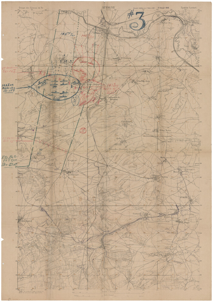
[Movements & Objectives of the 143rd & 144th Infantry on October 9-11, 1918, Appendix E, Nos.2 and 3]
Print $20.00
[Movements & Objectives of the 143rd & 144th Infantry on October 9-11, 1918, Appendix E, Nos.2 and 3]
1918
Size: 41.6 x 19.9 inches
94131
[Movements & Objectives of the 143rd & 144th Infantry on October 13, 1918, Appendix L]
Print $20.00
[Movements & Objectives of the 143rd & 144th Infantry on October 13, 1918, Appendix L]
1918
Size: 16.1 x 16.8 inches
94124
[Movements & Objectives of the 143rd & 144th Infantry on October 12-13, 1918] - Verso
Print $20.00
[Movements & Objectives of the 143rd & 144th Infantry on October 12-13, 1918] - Verso
1918
Size: 42.4 x 30.0 inches
94136
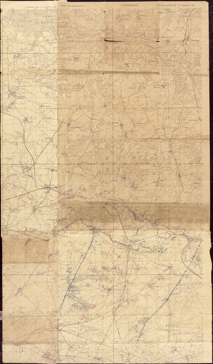
[Movements & Objectives of the 143rd & 144th Infantry on October 12-13, 1918]
Print $20.00
[Movements & Objectives of the 143rd & 144th Infantry on October 12-13, 1918]
1918
Size: 42.4 x 30.0 inches
94135
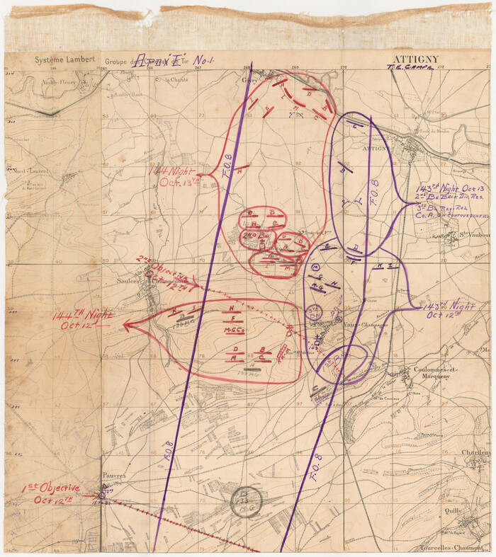
[Movements & Objectives of the 143rd & 144th Infantry on October 12-13, 1918, Appendix E, No.1]
Print $20.00
[Movements & Objectives of the 143rd & 144th Infantry on October 12-13, 1918, Appendix E, No.1]
1918
Size: 22.5 x 20.0 inches
94126
[Movements & Objectives of the 143rd & 144th Infantry and many other divisions and regiments, 1918] - Verso

Print $40.00
[Movements & Objectives of the 143rd & 144th Infantry and many other divisions and regiments, 1918] - Verso
1918
Size: 37.2 x 63.9 inches
94139
[Movements & Objectives of the 143rd & 144th Infantry and many other divisions and regiments, 1918]
Print $40.00
[Movements & Objectives of the 143rd & 144th Infantry and many other divisions and regiments, 1918]
1918
Size: 64.2 x 37.5 inches
94138
[Movements & Objectives of the 143rd & 144th Infantry & 133rd Machine Gun Battalion on October 8-9, 1918, Appendix E, No. 4] - Verso
Print $20.00
[Movements & Objectives of the 143rd & 144th Infantry & 133rd Machine Gun Battalion on October 8-9, 1918, Appendix E, No. 4] - Verso
1918
Size: 21.5 x 20.0 inches
94134
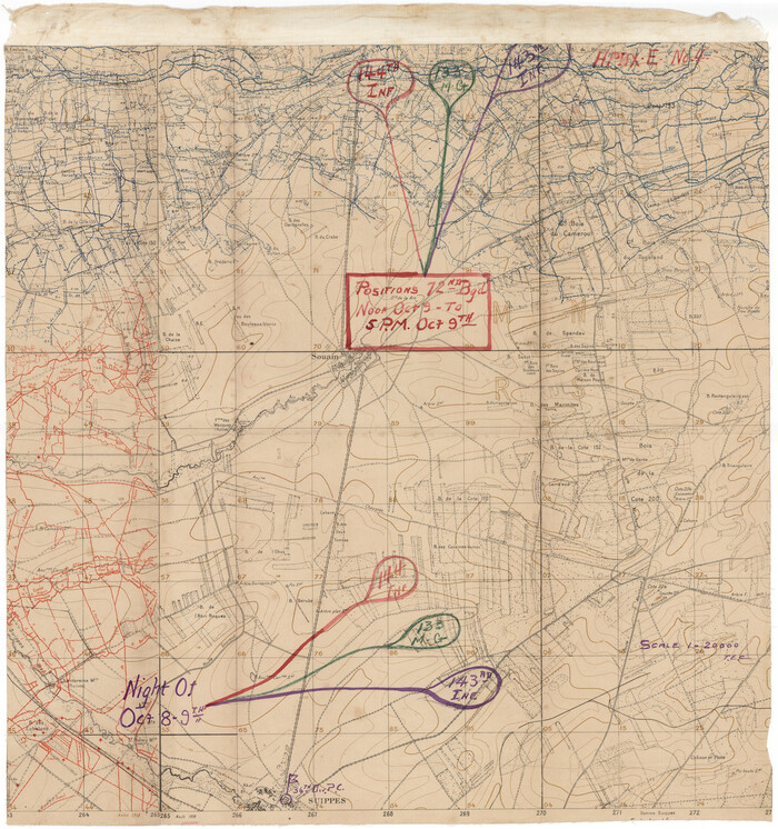
[Movements & Objectives of the 143rd & 144th Infantry & 133rd Machine Gun Battalion on October 8-9, 1918, Appendix E, No. 4]
Print $20.00
[Movements & Objectives of the 143rd & 144th Infantry & 133rd Machine Gun Battalion on October 8-9, 1918, Appendix E, No. 4]
1918
Size: 21.5 x 20.2 inches
94133
[Divisional Boundary and Brigade Boundary on October 22, 1918, Appendix P]
Print $20.00
[Divisional Boundary and Brigade Boundary on October 22, 1918, Appendix P]
1918
Size: 16.2 x 16.7 inches
94125
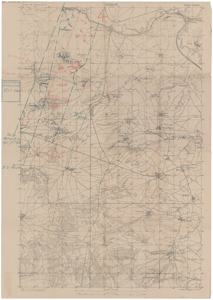
[Defensive Positions of the 143rd & 144th Infantry on October 14, 1918]
Print $20.00
[Defensive Positions of the 143rd & 144th Infantry on October 14, 1918]
1918
Size: 42.2 x 30.0 inches
94137
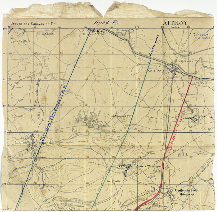
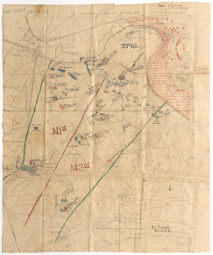
[1/4 of a WWI French map of Attigny used by the 142nd Infantry for planning purposes for the Battle of Forest Ferme (farm)]
Print $20.00
[1/4 of a WWI French map of Attigny used by the 142nd Infantry for planning purposes for the Battle of Forest Ferme (farm)]
1918
Size: 21.1 x 17.7 inches
96642

Terre Nove (verso)

Print $20.00
- Digital $50.00
Terre Nove (verso)
1522
Size: 12.2 x 7.8 inches
93802
Tabula Terre Nove

Print $20.00
- Digital $50.00
Tabula Terre Nove
1513
Size: 18.7 x 24.6 inches
93800


Map of the British Isles to illustrate Olney's school geography (Inset: Shetland Isles)

Print $20.00
- Digital $50.00
Map of the British Isles to illustrate Olney's school geography (Inset: Shetland Isles)
1844
Size: 12.1 x 9.5 inches
93547
Map of the British Isles designed to accompany Smith's Geography for Schools

Print $20.00
- Digital $50.00
Map of the British Isles designed to accompany Smith's Geography for Schools
1850
Size: 12.1 x 9.8 inches
93894
Map of Great Britain and Ireland engraved to illustrate Mitchell's school and family geography

Print $20.00
- Digital $50.00
Map of Great Britain and Ireland engraved to illustrate Mitchell's school and family geography
1840
Size: 11.8 x 9.5 inches
93503
Map of Great Britain and Ireland engraved to illustrate Mitchell's new intermediate geography

Print $20.00
- Digital $50.00
Map of Great Britain and Ireland engraved to illustrate Mitchell's new intermediate geography
1885
Size: 12.2 x 9.0 inches
93527
Map of Germany, Switzerland and Northern Italy engraved to illustrate Mitchell's school and family geography

Print $20.00
- Digital $50.00
Map of Germany, Switzerland and Northern Italy engraved to illustrate Mitchell's school and family geography
1840
Size: 11.8 x 9.5 inches
93504
Map of France, Spain, Portugal and Italy engraved to illustrate Mitchell's school and family geography (Inset: Greece and the Ionian Islands)

Print $20.00
- Digital $50.00
Map of France, Spain, Portugal and Italy engraved to illustrate Mitchell's school and family geography (Inset: Greece and the Ionian Islands)
1846
Size: 9.5 x 11.8 inches
93505
Map of Europe to illustrate Olney's school geography (Inset: Central Europe)

Print $20.00
- Digital $50.00
Map of Europe to illustrate Olney's school geography (Inset: Central Europe)
1844
Size: 12.1 x 19.0 inches
93546
Map of Europe engraved to illustrate the new intermediate geography

Print $20.00
- Digital $50.00
Map of Europe engraved to illustrate the new intermediate geography
1885
Size: 9.0 x 12.2 inches
93526
Map of Europe engraved to illustrate Mitchell's school and family geography

Print $20.00
- Digital $50.00
Map of Europe engraved to illustrate Mitchell's school and family geography
1839
Size: 9.5 x 11.8 inches
93502
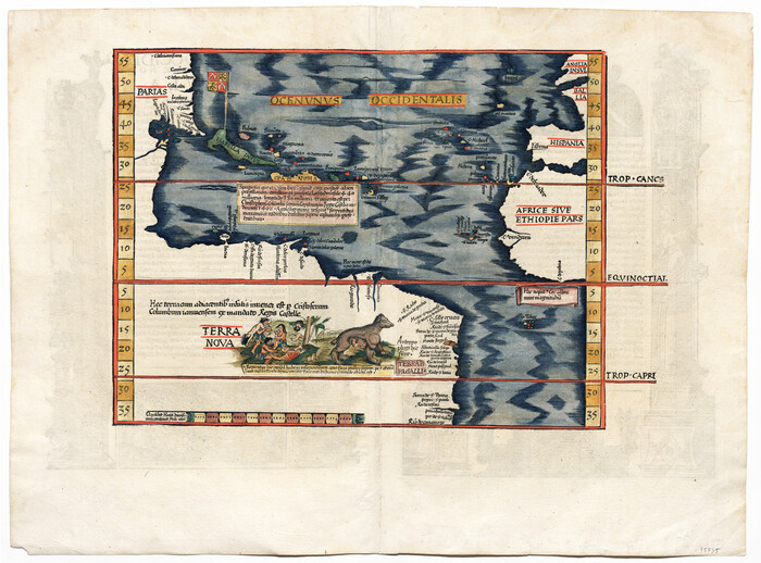
[Oceani occidentalis seu terrae novae tabula]
Print $20.00
- Digital $50.00
[Oceani occidentalis seu terrae novae tabula]
1535
-
Size
16.0 x 21.6 inches
-
Map/Doc
95835
-
Creation Date
1535
[Movements & Objectives of the 143rd & 144th Infantry on October 9-11, 1918, Appendix E, Nos.2 and 3] - Verso
Print $20.00
[Movements & Objectives of the 143rd & 144th Infantry on October 9-11, 1918, Appendix E, Nos.2 and 3] - Verso
1918
-
Size
41.9 x 20.2 inches
-
Map/Doc
94132
-
Creation Date
1918
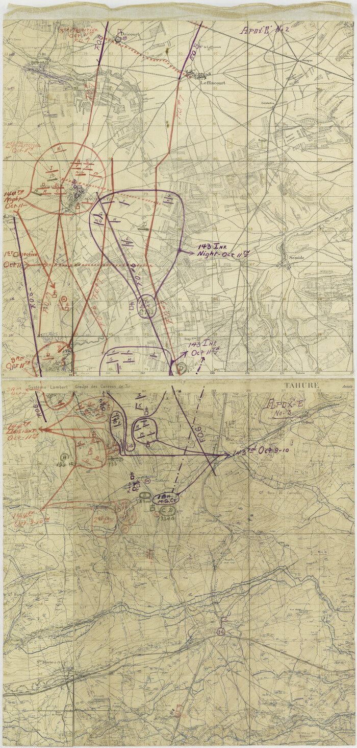
[Movements & Objectives of the 143rd & 144th Infantry on October 9-11, 1918, Appendix E, Nos.2 and 3]
Print $20.00
[Movements & Objectives of the 143rd & 144th Infantry on October 9-11, 1918, Appendix E, Nos.2 and 3]
1918
-
Size
41.6 x 19.9 inches
-
Map/Doc
94131
-
Creation Date
1918
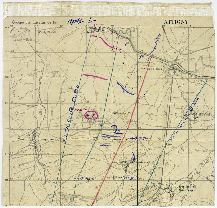
[Movements & Objectives of the 143rd & 144th Infantry on October 13, 1918, Appendix L]
Print $20.00
[Movements & Objectives of the 143rd & 144th Infantry on October 13, 1918, Appendix L]
1918
-
Size
16.1 x 16.8 inches
-
Map/Doc
94124
-
Creation Date
1918
[Movements & Objectives of the 143rd & 144th Infantry on October 12-13, 1918] - Verso
Print $20.00
[Movements & Objectives of the 143rd & 144th Infantry on October 12-13, 1918] - Verso
1918
-
Size
42.4 x 30.0 inches
-
Map/Doc
94136
-
Creation Date
1918
[Movements & Objectives of the 143rd & 144th Infantry on October 12-13, 1918]
Print $20.00
[Movements & Objectives of the 143rd & 144th Infantry on October 12-13, 1918]
1918
-
Size
42.4 x 30.0 inches
-
Map/Doc
94135
-
Creation Date
1918
[Movements & Objectives of the 143rd & 144th Infantry on October 12-13, 1918, Appendix E, No.1]
Print $20.00
[Movements & Objectives of the 143rd & 144th Infantry on October 12-13, 1918, Appendix E, No.1]
1918
-
Size
22.5 x 20.0 inches
-
Map/Doc
94126
-
Creation Date
1918
[Movements & Objectives of the 143rd & 144th Infantry and many other divisions and regiments, 1918] - Verso
Print $40.00
[Movements & Objectives of the 143rd & 144th Infantry and many other divisions and regiments, 1918] - Verso
1918
-
Size
37.2 x 63.9 inches
-
Map/Doc
94139
-
Creation Date
1918
[Movements & Objectives of the 143rd & 144th Infantry and many other divisions and regiments, 1918]
Print $40.00
[Movements & Objectives of the 143rd & 144th Infantry and many other divisions and regiments, 1918]
1918
-
Size
64.2 x 37.5 inches
-
Map/Doc
94138
-
Creation Date
1918
[Movements & Objectives of the 143rd & 144th Infantry & 133rd Machine Gun Battalion on October 8-9, 1918, Appendix E, No. 4] - Verso
Print $20.00
[Movements & Objectives of the 143rd & 144th Infantry & 133rd Machine Gun Battalion on October 8-9, 1918, Appendix E, No. 4] - Verso
1918
-
Size
21.5 x 20.0 inches
-
Map/Doc
94134
-
Creation Date
1918
[Movements & Objectives of the 143rd & 144th Infantry & 133rd Machine Gun Battalion on October 8-9, 1918, Appendix E, No. 4]
Print $20.00
[Movements & Objectives of the 143rd & 144th Infantry & 133rd Machine Gun Battalion on October 8-9, 1918, Appendix E, No. 4]
1918
-
Size
21.5 x 20.2 inches
-
Map/Doc
94133
-
Creation Date
1918
[Divisional Boundary and Brigade Boundary on October 22, 1918, Appendix P]
Print $20.00
[Divisional Boundary and Brigade Boundary on October 22, 1918, Appendix P]
1918
-
Size
16.2 x 16.7 inches
-
Map/Doc
94125
-
Creation Date
1918
[Defensive Positions of the 143rd & 144th Infantry on October 14, 1918]
Print $20.00
[Defensive Positions of the 143rd & 144th Infantry on October 14, 1918]
1918
-
Size
42.2 x 30.0 inches
-
Map/Doc
94137
-
Creation Date
1918
[1/4 of a WWI French map of Attigny used by the 142nd Infantry for planning purposes for the Battle of Forest Ferme (farm)]
Print $20.00
[1/4 of a WWI French map of Attigny used by the 142nd Infantry for planning purposes for the Battle of Forest Ferme (farm)]
1918
-
Size
21.1 x 17.7 inches
-
Map/Doc
96642
-
Creation Date
1918
Terre Nove (verso)
Print $20.00
- Digital $50.00
Terre Nove (verso)
1522
-
Size
12.2 x 7.8 inches
-
Map/Doc
93802
-
Creation Date
1522
Terre Nove

Print $20.00
- Digital $50.00
Terre Nove
1522
-
Size
13.2 x 18.5 inches
-
Map/Doc
93801
-
Creation Date
1522
Tabula Terre Nove
Print $20.00
- Digital $50.00
Tabula Terre Nove
1513
-
Size
18.7 x 24.6 inches
-
Map/Doc
93800
-
Creation Date
1513
Poland and Czechoslovakia

Poland and Czechoslovakia
1958
-
Size
25.6 x 19.6 inches
-
Map/Doc
92381
-
Creation Date
1958
Map of the British Isles to illustrate Olney's school geography (Inset: Shetland Isles)
Print $20.00
- Digital $50.00
Map of the British Isles to illustrate Olney's school geography (Inset: Shetland Isles)
1844
-
Size
12.1 x 9.5 inches
-
Map/Doc
93547
-
Creation Date
1844
Map of the British Isles designed to accompany Smith's Geography for Schools
Print $20.00
- Digital $50.00
Map of the British Isles designed to accompany Smith's Geography for Schools
1850
-
Size
12.1 x 9.8 inches
-
Map/Doc
93894
-
Creation Date
1850
Map of Great Britain and Ireland engraved to illustrate Mitchell's school and family geography
Print $20.00
- Digital $50.00
Map of Great Britain and Ireland engraved to illustrate Mitchell's school and family geography
1840
-
Size
11.8 x 9.5 inches
-
Map/Doc
93503
-
Creation Date
1840
Map of Great Britain and Ireland engraved to illustrate Mitchell's new intermediate geography
Print $20.00
- Digital $50.00
Map of Great Britain and Ireland engraved to illustrate Mitchell's new intermediate geography
1885
-
Size
12.2 x 9.0 inches
-
Map/Doc
93527
-
Creation Date
1885
Map of Germany, Switzerland and Northern Italy engraved to illustrate Mitchell's school and family geography
Print $20.00
- Digital $50.00
Map of Germany, Switzerland and Northern Italy engraved to illustrate Mitchell's school and family geography
1840
-
Size
11.8 x 9.5 inches
-
Map/Doc
93504
-
Creation Date
1840
Map of France, Spain, Portugal and Italy engraved to illustrate Mitchell's school and family geography (Inset: Greece and the Ionian Islands)
Print $20.00
- Digital $50.00
Map of France, Spain, Portugal and Italy engraved to illustrate Mitchell's school and family geography (Inset: Greece and the Ionian Islands)
1846
-
Size
9.5 x 11.8 inches
-
Map/Doc
93505
-
Creation Date
1846
Map of Europe to illustrate Olney's school geography (Inset: Central Europe)
Print $20.00
- Digital $50.00
Map of Europe to illustrate Olney's school geography (Inset: Central Europe)
1844
-
Size
12.1 x 19.0 inches
-
Map/Doc
93546
-
Creation Date
1844
Map of Europe engraved to illustrate the new intermediate geography
Print $20.00
- Digital $50.00
Map of Europe engraved to illustrate the new intermediate geography
1885
-
Size
9.0 x 12.2 inches
-
Map/Doc
93526
-
Creation Date
1885
Map of Europe engraved to illustrate Mitchell's school and family geography
Print $20.00
- Digital $50.00
Map of Europe engraved to illustrate Mitchell's school and family geography
1839
-
Size
9.5 x 11.8 inches
-
Map/Doc
93502
-
Creation Date
1839