

Lands of the Eastern Mediterranean

Lands of the Eastern Mediterranean
1959
Size: 25.5 x 19.5 inches
92383


Engineer map showing engineer information at 23 O'Clock 23 Oct. 1918 drawn under direction of Col. W.A. Mitchell

Print $20.00
Engineer map showing engineer information at 23 O'Clock 23 Oct. 1918 drawn under direction of Col. W.A. Mitchell
1918
Size: 19.6 x 12.5 inches
94127
Engineer map showing engineer information at 23 O'Clock 23 Oct. 1918 drawn under direction of Col. W.A. Mitchell - Verso

Print $20.00
Engineer map showing engineer information at 23 O'Clock 23 Oct. 1918 drawn under direction of Col. W.A. Mitchell - Verso
1918
Size: 19.7 x 12.6 inches
94128
[Movements & Objectives of the 143rd & 144th Infantry and many other divisions and regiments, 1918] - Verso

Print $40.00
[Movements & Objectives of the 143rd & 144th Infantry and many other divisions and regiments, 1918] - Verso
1918
Size: 37.2 x 63.9 inches
94139
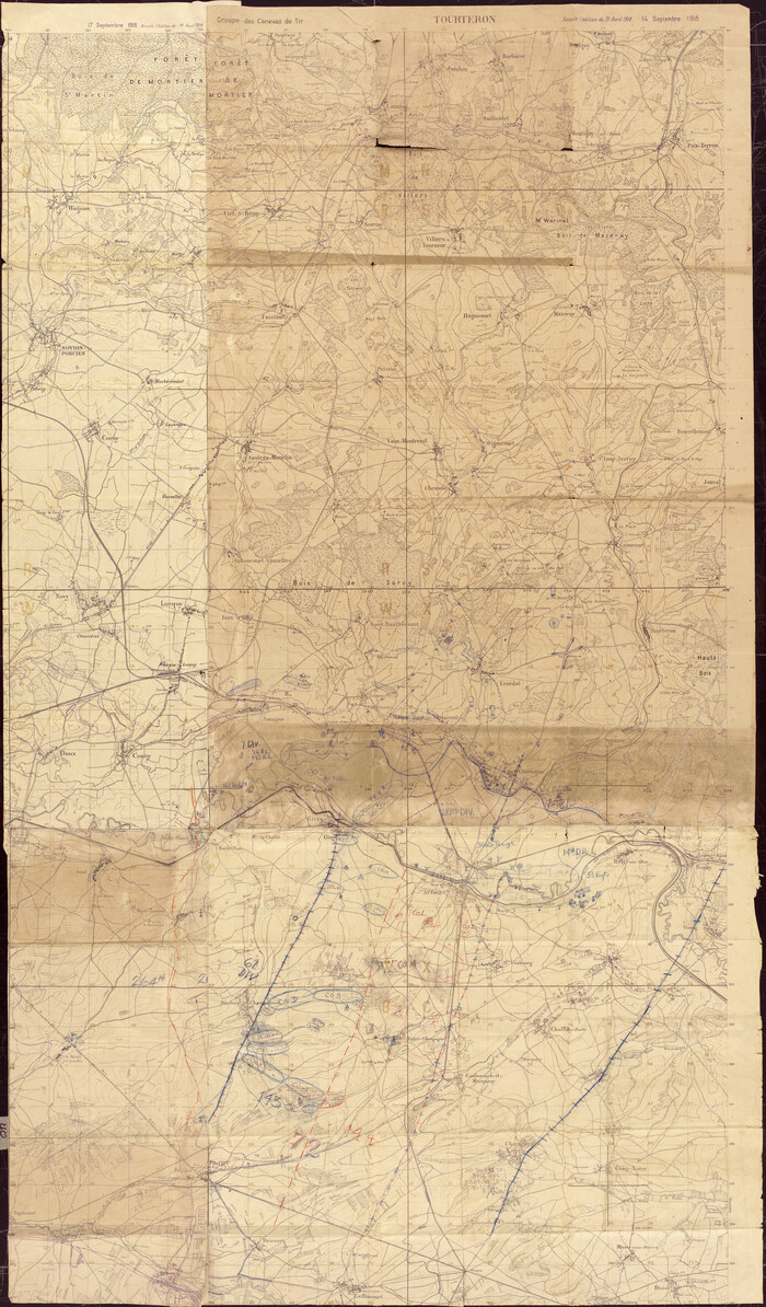
[Movements & Objectives of the 143rd & 144th Infantry and many other divisions and regiments, 1918]
Print $40.00
[Movements & Objectives of the 143rd & 144th Infantry and many other divisions and regiments, 1918]
1918
Size: 64.2 x 37.5 inches
94138
[Movements & Objectives of the 143rd & 144th Infantry on October 12-13, 1918]
Print $20.00
[Movements & Objectives of the 143rd & 144th Infantry on October 12-13, 1918]
1918
Size: 42.4 x 30.0 inches
94135
[Movements & Objectives of the 143rd & 144th Infantry on October 12-13, 1918] - Verso
Print $20.00
[Movements & Objectives of the 143rd & 144th Infantry on October 12-13, 1918] - Verso
1918
Size: 42.4 x 30.0 inches
94136
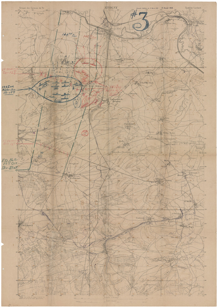
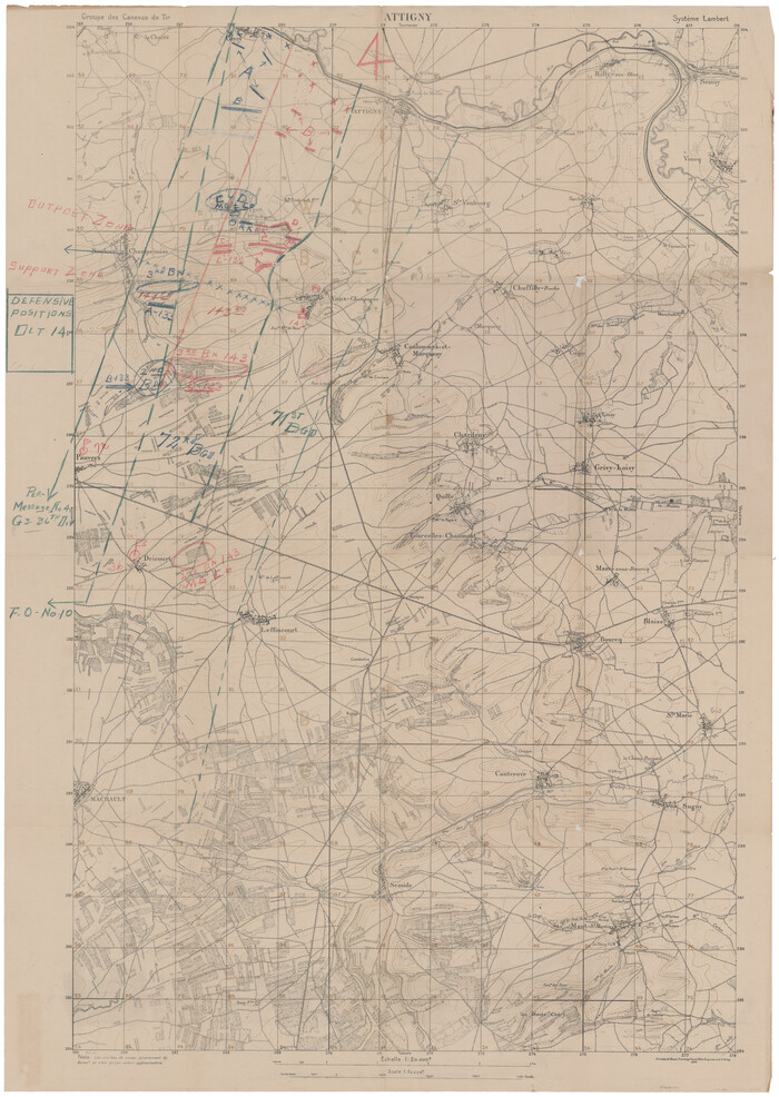
[1/4 of a WWI French map of Attigny used by the 142nd Infantry for planning purposes for the Battle of Forest Ferme (farm)]
Print $20.00
[1/4 of a WWI French map of Attigny used by the 142nd Infantry for planning purposes for the Battle of Forest Ferme (farm)]
1918
Size: 21.1 x 17.7 inches
96642
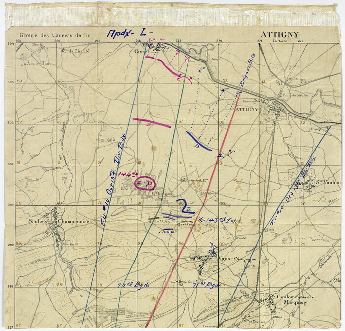
[Movements & Objectives of the 143rd & 144th Infantry on October 13, 1918, Appendix L]
Print $20.00
[Movements & Objectives of the 143rd & 144th Infantry on October 13, 1918, Appendix L]
1918
Size: 16.1 x 16.8 inches
94124
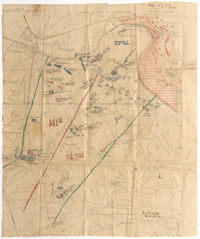
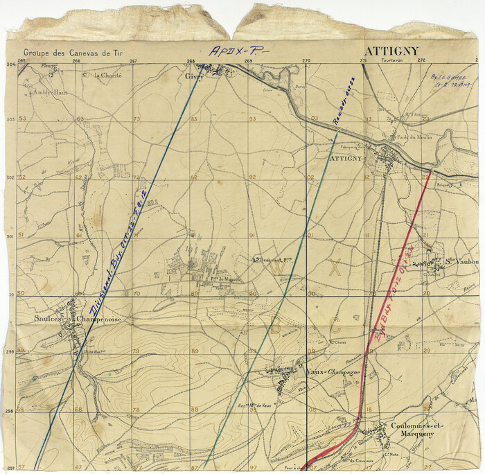
[Divisional Boundary and Brigade Boundary on October 22, 1918, Appendix P]
Print $20.00
[Divisional Boundary and Brigade Boundary on October 22, 1918, Appendix P]
1918
Size: 16.2 x 16.7 inches
94125
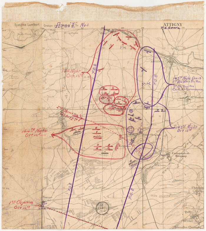
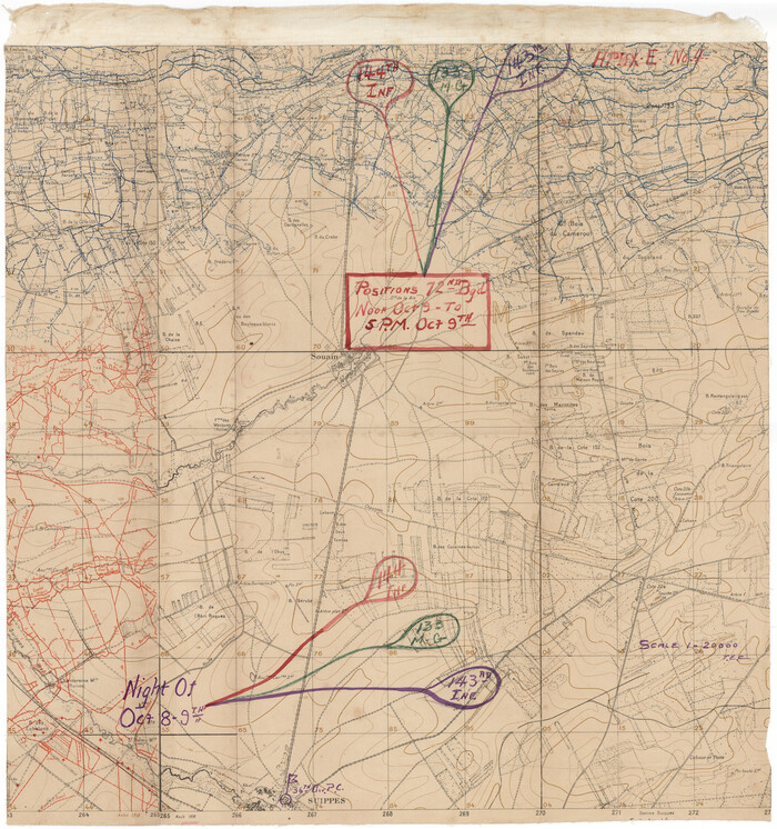
[Movements & Objectives of the 143rd & 144th Infantry on October 12-13, 1918, Appendix E, No.1]
Print $20.00
[Movements & Objectives of the 143rd & 144th Infantry on October 12-13, 1918, Appendix E, No.1]
1918
Size: 22.5 x 20.0 inches
94126
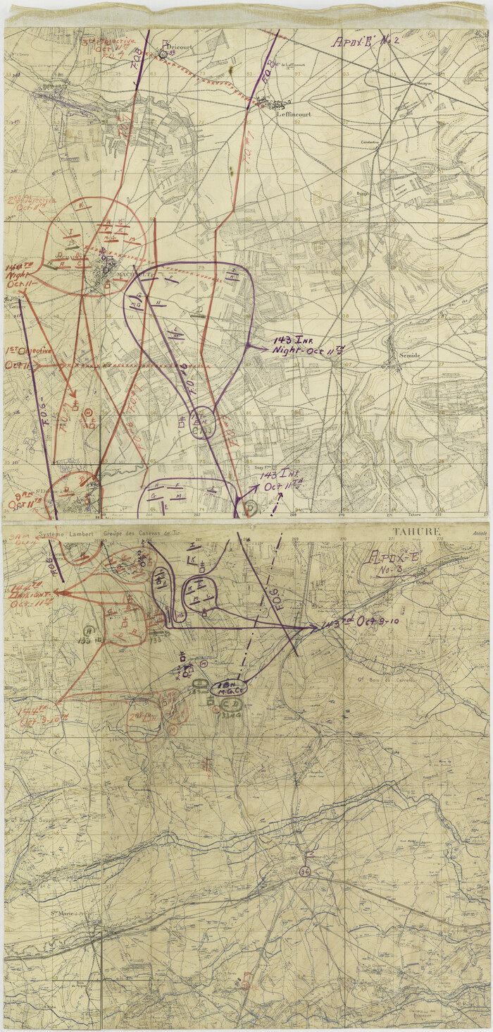
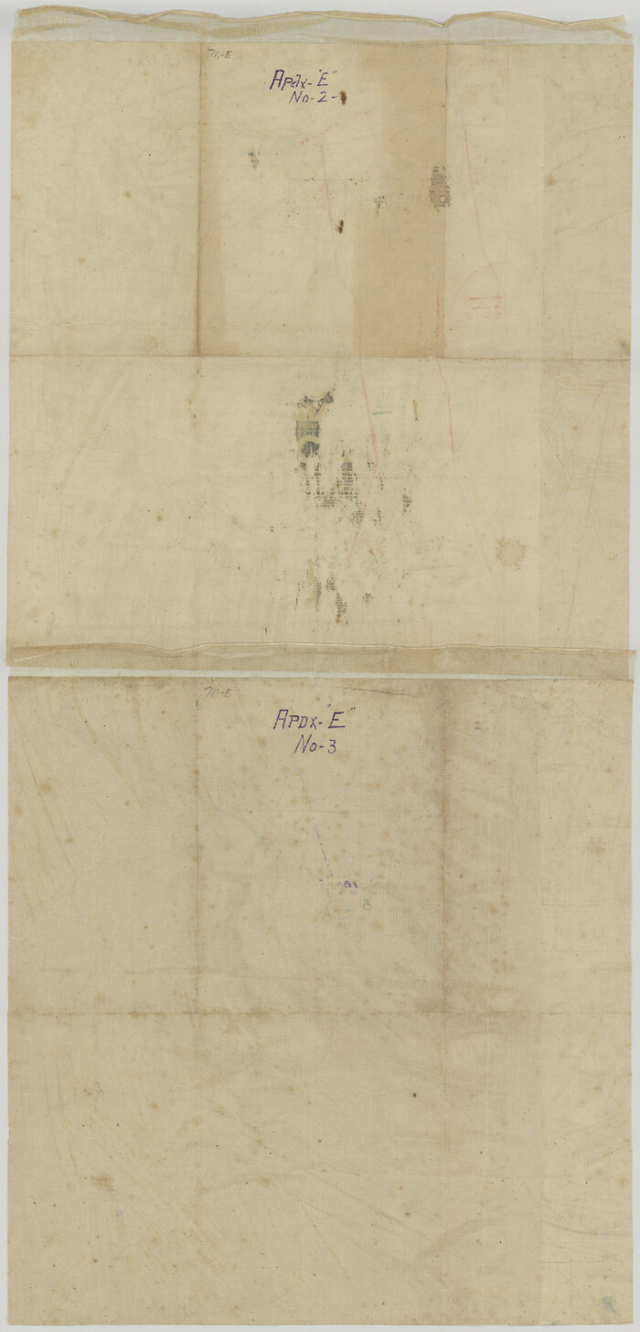
[Movements & Objectives of the 143rd & 144th Infantry on October 9-11, 1918, Appendix E, Nos.2 and 3]
Print $20.00
[Movements & Objectives of the 143rd & 144th Infantry on October 9-11, 1918, Appendix E, Nos.2 and 3]
1918
Size: 41.6 x 19.9 inches
94131
[Movements & Objectives of the 143rd & 144th Infantry on October 9-11, 1918, Appendix E, Nos.2 and 3] - Verso
Print $20.00
[Movements & Objectives of the 143rd & 144th Infantry on October 9-11, 1918, Appendix E, Nos.2 and 3] - Verso
1918
Size: 41.9 x 20.2 inches
94132
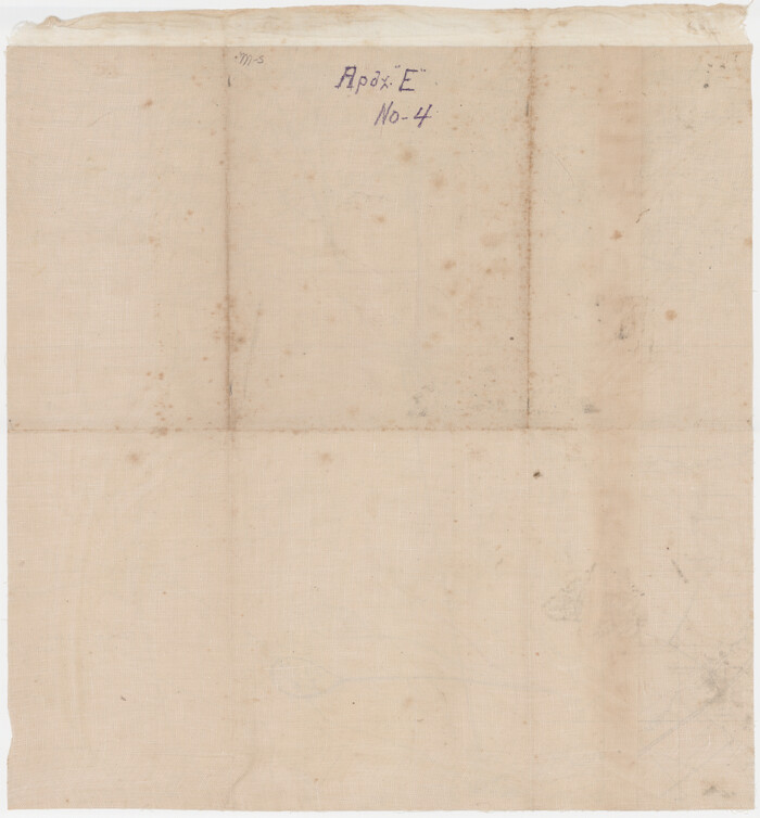
[Movements & Objectives of the 143rd & 144th Infantry & 133rd Machine Gun Battalion on October 8-9, 1918, Appendix E, No. 4]
Print $20.00
[Movements & Objectives of the 143rd & 144th Infantry & 133rd Machine Gun Battalion on October 8-9, 1918, Appendix E, No. 4]
1918
Size: 21.5 x 20.2 inches
94133
[Movements & Objectives of the 143rd & 144th Infantry & 133rd Machine Gun Battalion on October 8-9, 1918, Appendix E, No. 4] - Verso
Print $20.00
[Movements & Objectives of the 143rd & 144th Infantry & 133rd Machine Gun Battalion on October 8-9, 1918, Appendix E, No. 4] - Verso
1918
Size: 21.5 x 20.0 inches
94134
[Defensive Positions of the 143rd & 144th Infantry on October 14, 1918]
Print $20.00
[Defensive Positions of the 143rd & 144th Infantry on October 14, 1918]
1918
Size: 42.2 x 30.0 inches
94137
Eastern Hemisphere

Print $20.00
- Digital $50.00
Eastern Hemisphere
1885
Size: 12.2 x 9.0 inches
93511
Map of Europe engraved to illustrate the new intermediate geography

Print $20.00
- Digital $50.00
Map of Europe engraved to illustrate the new intermediate geography
1885
Size: 9.0 x 12.2 inches
93526
Map of Great Britain and Ireland engraved to illustrate Mitchell's new intermediate geography

Print $20.00
- Digital $50.00
Map of Great Britain and Ireland engraved to illustrate Mitchell's new intermediate geography
1885
Size: 12.2 x 9.0 inches
93527
Map of Central Europe engraved to illustrate Mitchell's new intermediate geography

Print $20.00
- Digital $50.00
Map of Central Europe engraved to illustrate Mitchell's new intermediate geography
1885
Size: 9.0 x 12.2 inches
93528
Map of Europe designed to accompany Smith's Geography for Schools

Print $20.00
- Digital $50.00
Map of Europe designed to accompany Smith's Geography for Schools
1850
Size: 9.8 x 12.1 inches
93892
Map of the British Isles designed to accompany Smith's Geography for Schools

Print $20.00
- Digital $50.00
Map of the British Isles designed to accompany Smith's Geography for Schools
1850
Size: 12.1 x 9.8 inches
93894
Central Europe designed to accompany Smith's Geography for Schools

Print $20.00
- Digital $50.00
Central Europe designed to accompany Smith's Geography for Schools
1850
Size: 12.1 x 9.8 inches
93895
Lands of the Eastern Mediterranean
Lands of the Eastern Mediterranean
1959
-
Size
25.5 x 19.5 inches
-
Map/Doc
92383
-
Creation Date
1959
Greece and the Aegean

Greece and the Aegean
1958
-
Size
25.9 x 19.6 inches
-
Map/Doc
92380
-
Creation Date
1958
Poland and Czechoslovakia

Poland and Czechoslovakia
1958
-
Size
25.6 x 19.6 inches
-
Map/Doc
92381
-
Creation Date
1958
Engineer map showing engineer information at 23 O'Clock 23 Oct. 1918 drawn under direction of Col. W.A. Mitchell
Print $20.00
Engineer map showing engineer information at 23 O'Clock 23 Oct. 1918 drawn under direction of Col. W.A. Mitchell
1918
-
Size
19.6 x 12.5 inches
-
Map/Doc
94127
-
Creation Date
1918
Engineer map showing engineer information at 23 O'Clock 23 Oct. 1918 drawn under direction of Col. W.A. Mitchell - Verso
Print $20.00
Engineer map showing engineer information at 23 O'Clock 23 Oct. 1918 drawn under direction of Col. W.A. Mitchell - Verso
1918
-
Size
19.7 x 12.6 inches
-
Map/Doc
94128
-
Creation Date
1918
[Movements & Objectives of the 143rd & 144th Infantry and many other divisions and regiments, 1918] - Verso
Print $40.00
[Movements & Objectives of the 143rd & 144th Infantry and many other divisions and regiments, 1918] - Verso
1918
-
Size
37.2 x 63.9 inches
-
Map/Doc
94139
-
Creation Date
1918
[Movements & Objectives of the 143rd & 144th Infantry and many other divisions and regiments, 1918]
Print $40.00
[Movements & Objectives of the 143rd & 144th Infantry and many other divisions and regiments, 1918]
1918
-
Size
64.2 x 37.5 inches
-
Map/Doc
94138
-
Creation Date
1918
[Movements & Objectives of the 143rd & 144th Infantry on October 12-13, 1918]
Print $20.00
[Movements & Objectives of the 143rd & 144th Infantry on October 12-13, 1918]
1918
-
Size
42.4 x 30.0 inches
-
Map/Doc
94135
-
Creation Date
1918
[Movements & Objectives of the 143rd & 144th Infantry on October 12-13, 1918] - Verso
Print $20.00
[Movements & Objectives of the 143rd & 144th Infantry on October 12-13, 1918] - Verso
1918
-
Size
42.4 x 30.0 inches
-
Map/Doc
94136
-
Creation Date
1918
[1/4 of a WWI French map of Attigny used by the 142nd Infantry for planning purposes for the Battle of Forest Ferme (farm)]
Print $20.00
[1/4 of a WWI French map of Attigny used by the 142nd Infantry for planning purposes for the Battle of Forest Ferme (farm)]
1918
-
Size
21.1 x 17.7 inches
-
Map/Doc
96642
-
Creation Date
1918
[Movements & Objectives of the 143rd & 144th Infantry on October 13, 1918, Appendix L]
Print $20.00
[Movements & Objectives of the 143rd & 144th Infantry on October 13, 1918, Appendix L]
1918
-
Size
16.1 x 16.8 inches
-
Map/Doc
94124
-
Creation Date
1918
[Divisional Boundary and Brigade Boundary on October 22, 1918, Appendix P]
Print $20.00
[Divisional Boundary and Brigade Boundary on October 22, 1918, Appendix P]
1918
-
Size
16.2 x 16.7 inches
-
Map/Doc
94125
-
Creation Date
1918
[Movements & Objectives of the 143rd & 144th Infantry on October 12-13, 1918, Appendix E, No.1]
Print $20.00
[Movements & Objectives of the 143rd & 144th Infantry on October 12-13, 1918, Appendix E, No.1]
1918
-
Size
22.5 x 20.0 inches
-
Map/Doc
94126
-
Creation Date
1918
[Movements & Objectives of the 143rd & 144th Infantry on October 9-11, 1918, Appendix E, Nos.2 and 3]
Print $20.00
[Movements & Objectives of the 143rd & 144th Infantry on October 9-11, 1918, Appendix E, Nos.2 and 3]
1918
-
Size
41.6 x 19.9 inches
-
Map/Doc
94131
-
Creation Date
1918
[Movements & Objectives of the 143rd & 144th Infantry on October 9-11, 1918, Appendix E, Nos.2 and 3] - Verso
Print $20.00
[Movements & Objectives of the 143rd & 144th Infantry on October 9-11, 1918, Appendix E, Nos.2 and 3] - Verso
1918
-
Size
41.9 x 20.2 inches
-
Map/Doc
94132
-
Creation Date
1918
[Movements & Objectives of the 143rd & 144th Infantry & 133rd Machine Gun Battalion on October 8-9, 1918, Appendix E, No. 4]
Print $20.00
[Movements & Objectives of the 143rd & 144th Infantry & 133rd Machine Gun Battalion on October 8-9, 1918, Appendix E, No. 4]
1918
-
Size
21.5 x 20.2 inches
-
Map/Doc
94133
-
Creation Date
1918
[Movements & Objectives of the 143rd & 144th Infantry & 133rd Machine Gun Battalion on October 8-9, 1918, Appendix E, No. 4] - Verso
Print $20.00
[Movements & Objectives of the 143rd & 144th Infantry & 133rd Machine Gun Battalion on October 8-9, 1918, Appendix E, No. 4] - Verso
1918
-
Size
21.5 x 20.0 inches
-
Map/Doc
94134
-
Creation Date
1918
[Defensive Positions of the 143rd & 144th Infantry on October 14, 1918]
Print $20.00
[Defensive Positions of the 143rd & 144th Infantry on October 14, 1918]
1918
-
Size
42.2 x 30.0 inches
-
Map/Doc
94137
-
Creation Date
1918
Eastern Hemisphere
Print $20.00
- Digital $50.00
Eastern Hemisphere
1885
-
Size
12.2 x 9.0 inches
-
Map/Doc
93511
-
Creation Date
1885
Map of Europe engraved to illustrate the new intermediate geography
Print $20.00
- Digital $50.00
Map of Europe engraved to illustrate the new intermediate geography
1885
-
Size
9.0 x 12.2 inches
-
Map/Doc
93526
-
Creation Date
1885
Map of Great Britain and Ireland engraved to illustrate Mitchell's new intermediate geography
Print $20.00
- Digital $50.00
Map of Great Britain and Ireland engraved to illustrate Mitchell's new intermediate geography
1885
-
Size
12.2 x 9.0 inches
-
Map/Doc
93527
-
Creation Date
1885
Map of Central Europe engraved to illustrate Mitchell's new intermediate geography
Print $20.00
- Digital $50.00
Map of Central Europe engraved to illustrate Mitchell's new intermediate geography
1885
-
Size
9.0 x 12.2 inches
-
Map/Doc
93528
-
Creation Date
1885
Map of Europe designed to accompany Smith's Geography for Schools
Print $20.00
- Digital $50.00
Map of Europe designed to accompany Smith's Geography for Schools
1850
-
Size
9.8 x 12.1 inches
-
Map/Doc
93892
-
Creation Date
1850
Map of the British Isles designed to accompany Smith's Geography for Schools
Print $20.00
- Digital $50.00
Map of the British Isles designed to accompany Smith's Geography for Schools
1850
-
Size
12.1 x 9.8 inches
-
Map/Doc
93894
-
Creation Date
1850
Central Europe designed to accompany Smith's Geography for Schools
Print $20.00
- Digital $50.00
Central Europe designed to accompany Smith's Geography for Schools
1850
-
Size
12.1 x 9.8 inches
-
Map/Doc
93895
-
Creation Date
1850