
Dépt. des Basses-Alpes

Print $20.00
- Digital $50.00
Dépt. des Basses-Alpes
Size: 13.9 x 20.3 inches
94450
A Traveler's Map of Spain and Portugal

A Traveler's Map of Spain and Portugal
Size: 20.4 x 31.2 inches
95929

A Traveler's Map of Spain and Portugal

A Traveler's Map of Spain and Portugal
Size: 36.1 x 22.9 inches
95937
A Traveler's Map of Spain and Portugal

A Traveler's Map of Spain and Portugal
Size: 22.8 x 36.3 inches
95938
Tabula Terre Nove

Print $20.00
- Digital $50.00
Tabula Terre Nove
1513
Size: 18.7 x 24.6 inches
93800
Terre Nove (verso)

Print $20.00
- Digital $50.00
Terre Nove (verso)
1522
Size: 12.2 x 7.8 inches
93802
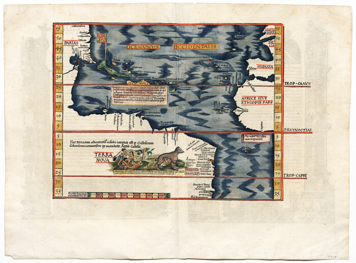
[Oceani occidentalis seu terrae novae tabula]
Print $20.00
- Digital $50.00
[Oceani occidentalis seu terrae novae tabula]
1535
Size: 16.0 x 21.6 inches
95835
A General Map of the Roman Empire Shewing the Situation of all its Provinces & ye Seats of ye Barbarous Nations on their Frontiers

Print $20.00
- Digital $50.00
A General Map of the Roman Empire Shewing the Situation of all its Provinces & ye Seats of ye Barbarous Nations on their Frontiers
1744
Size: 10.8 x 20.5 inches
96644
A general map of Great Britain and Ireland with part of Holland, Flanders, France & agreable to modern history

Print $20.00
A general map of Great Britain and Ireland with part of Holland, Flanders, France & agreable to modern history
1750
Size: 21.6 x 25.7 inches
97435
A New Map, or Chart in Mercators Projection, of the Western or Atlantic Ocean, with part of Europe, Africa and America

Print $20.00
- Digital $50.00
A New Map, or Chart in Mercators Projection, of the Western or Atlantic Ocean, with part of Europe, Africa and America
1781
Size: 17.3 x 21.7 inches
95368

Map of Europe engraved to illustrate Mitchell's school and family geography

Print $20.00
- Digital $50.00
Map of Europe engraved to illustrate Mitchell's school and family geography
1839
Size: 9.5 x 11.8 inches
93502
Map of Great Britain and Ireland engraved to illustrate Mitchell's school and family geography

Print $20.00
- Digital $50.00
Map of Great Britain and Ireland engraved to illustrate Mitchell's school and family geography
1840
Size: 11.8 x 9.5 inches
93503
Map of Germany, Switzerland and Northern Italy engraved to illustrate Mitchell's school and family geography

Print $20.00
- Digital $50.00
Map of Germany, Switzerland and Northern Italy engraved to illustrate Mitchell's school and family geography
1840
Size: 11.8 x 9.5 inches
93504
Map of Europe to illustrate Olney's school geography (Inset: Central Europe)

Print $20.00
- Digital $50.00
Map of Europe to illustrate Olney's school geography (Inset: Central Europe)
1844
Size: 12.1 x 19.0 inches
93546
Map of the British Isles to illustrate Olney's school geography (Inset: Shetland Isles)

Print $20.00
- Digital $50.00
Map of the British Isles to illustrate Olney's school geography (Inset: Shetland Isles)
1844
Size: 12.1 x 9.5 inches
93547
Map of France, Spain, Portugal and Italy engraved to illustrate Mitchell's school and family geography (Inset: Greece and the Ionian Islands)

Print $20.00
- Digital $50.00
Map of France, Spain, Portugal and Italy engraved to illustrate Mitchell's school and family geography (Inset: Greece and the Ionian Islands)
1846
Size: 9.5 x 11.8 inches
93505
Map of Europe designed to accompany Smith's Geography for Schools

Print $20.00
- Digital $50.00
Map of Europe designed to accompany Smith's Geography for Schools
1850
Size: 9.8 x 12.1 inches
93892
Map of the British Isles designed to accompany Smith's Geography for Schools

Print $20.00
- Digital $50.00
Map of the British Isles designed to accompany Smith's Geography for Schools
1850
Size: 12.1 x 9.8 inches
93894
Central Europe designed to accompany Smith's Geography for Schools

Print $20.00
- Digital $50.00
Central Europe designed to accompany Smith's Geography for Schools
1850
Size: 12.1 x 9.8 inches
93895
Eastern Hemisphere

Print $20.00
- Digital $50.00
Eastern Hemisphere
1885
Size: 12.2 x 9.0 inches
93511
Map of Europe engraved to illustrate the new intermediate geography

Print $20.00
- Digital $50.00
Map of Europe engraved to illustrate the new intermediate geography
1885
Size: 9.0 x 12.2 inches
93526
Map of Great Britain and Ireland engraved to illustrate Mitchell's new intermediate geography

Print $20.00
- Digital $50.00
Map of Great Britain and Ireland engraved to illustrate Mitchell's new intermediate geography
1885
Size: 12.2 x 9.0 inches
93527
Map of Central Europe engraved to illustrate Mitchell's new intermediate geography

Print $20.00
- Digital $50.00
Map of Central Europe engraved to illustrate Mitchell's new intermediate geography
1885
Size: 9.0 x 12.2 inches
93528
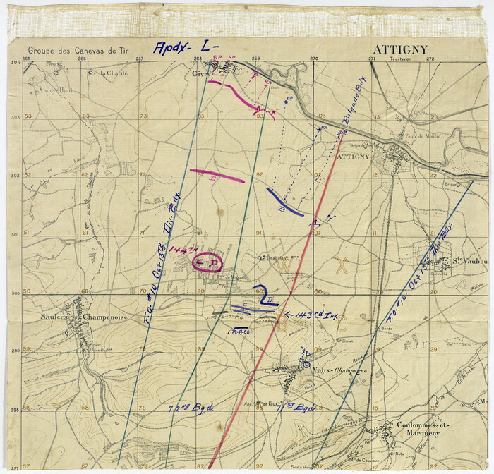
[Movements & Objectives of the 143rd & 144th Infantry on October 13, 1918, Appendix L]
Print $20.00
[Movements & Objectives of the 143rd & 144th Infantry on October 13, 1918, Appendix L]
1918
Size: 16.1 x 16.8 inches
94124
Dépt. des Ardennes

Print $20.00
- Digital $50.00
Dépt. des Ardennes
-
Size
14.5 x 20.5 inches
-
Map/Doc
94448
Dépt. des Basses-Alpes
Print $20.00
- Digital $50.00
Dépt. des Basses-Alpes
-
Size
13.9 x 20.3 inches
-
Map/Doc
94450
Dépt. de la Nièvre

Print $20.00
- Digital $50.00
Dépt. de la Nièvre
-
Size
14.5 x 20.3 inches
-
Map/Doc
94452
A Traveler's Map of Spain and Portugal
A Traveler's Map of Spain and Portugal
-
Size
20.4 x 31.2 inches
-
Map/Doc
95929
A Traveler's Map of Spain and Portugal
A Traveler's Map of Spain and Portugal
-
Size
36.1 x 22.9 inches
-
Map/Doc
95937
A Traveler's Map of Spain and Portugal
A Traveler's Map of Spain and Portugal
-
Size
22.8 x 36.3 inches
-
Map/Doc
95938
Tabula Terre Nove
Print $20.00
- Digital $50.00
Tabula Terre Nove
1513
-
Size
18.7 x 24.6 inches
-
Map/Doc
93800
-
Creation Date
1513
Terre Nove

Print $20.00
- Digital $50.00
Terre Nove
1522
-
Size
13.2 x 18.5 inches
-
Map/Doc
93801
-
Creation Date
1522
Terre Nove (verso)
Print $20.00
- Digital $50.00
Terre Nove (verso)
1522
-
Size
12.2 x 7.8 inches
-
Map/Doc
93802
-
Creation Date
1522
[Oceani occidentalis seu terrae novae tabula]
Print $20.00
- Digital $50.00
[Oceani occidentalis seu terrae novae tabula]
1535
-
Size
16.0 x 21.6 inches
-
Map/Doc
95835
-
Creation Date
1535
A General Map of the Roman Empire Shewing the Situation of all its Provinces & ye Seats of ye Barbarous Nations on their Frontiers
Print $20.00
- Digital $50.00
A General Map of the Roman Empire Shewing the Situation of all its Provinces & ye Seats of ye Barbarous Nations on their Frontiers
1744
-
Size
10.8 x 20.5 inches
-
Map/Doc
96644
-
Creation Date
1744
A general map of Great Britain and Ireland with part of Holland, Flanders, France & agreable to modern history
Print $20.00
A general map of Great Britain and Ireland with part of Holland, Flanders, France & agreable to modern history
1750
-
Size
21.6 x 25.7 inches
-
Map/Doc
97435
-
Creation Date
1750
A New Map, or Chart in Mercators Projection, of the Western or Atlantic Ocean, with part of Europe, Africa and America
Print $20.00
- Digital $50.00
A New Map, or Chart in Mercators Projection, of the Western or Atlantic Ocean, with part of Europe, Africa and America
1781
-
Size
17.3 x 21.7 inches
-
Map/Doc
95368
-
Creation Date
1781
Map of Europe engraved to illustrate Mitchell's school and family geography
Print $20.00
- Digital $50.00
Map of Europe engraved to illustrate Mitchell's school and family geography
1839
-
Size
9.5 x 11.8 inches
-
Map/Doc
93502
-
Creation Date
1839
Map of Great Britain and Ireland engraved to illustrate Mitchell's school and family geography
Print $20.00
- Digital $50.00
Map of Great Britain and Ireland engraved to illustrate Mitchell's school and family geography
1840
-
Size
11.8 x 9.5 inches
-
Map/Doc
93503
-
Creation Date
1840
Map of Germany, Switzerland and Northern Italy engraved to illustrate Mitchell's school and family geography
Print $20.00
- Digital $50.00
Map of Germany, Switzerland and Northern Italy engraved to illustrate Mitchell's school and family geography
1840
-
Size
11.8 x 9.5 inches
-
Map/Doc
93504
-
Creation Date
1840
Map of Europe to illustrate Olney's school geography (Inset: Central Europe)
Print $20.00
- Digital $50.00
Map of Europe to illustrate Olney's school geography (Inset: Central Europe)
1844
-
Size
12.1 x 19.0 inches
-
Map/Doc
93546
-
Creation Date
1844
Map of the British Isles to illustrate Olney's school geography (Inset: Shetland Isles)
Print $20.00
- Digital $50.00
Map of the British Isles to illustrate Olney's school geography (Inset: Shetland Isles)
1844
-
Size
12.1 x 9.5 inches
-
Map/Doc
93547
-
Creation Date
1844
Map of France, Spain, Portugal and Italy engraved to illustrate Mitchell's school and family geography (Inset: Greece and the Ionian Islands)
Print $20.00
- Digital $50.00
Map of France, Spain, Portugal and Italy engraved to illustrate Mitchell's school and family geography (Inset: Greece and the Ionian Islands)
1846
-
Size
9.5 x 11.8 inches
-
Map/Doc
93505
-
Creation Date
1846
Map of Europe designed to accompany Smith's Geography for Schools
Print $20.00
- Digital $50.00
Map of Europe designed to accompany Smith's Geography for Schools
1850
-
Size
9.8 x 12.1 inches
-
Map/Doc
93892
-
Creation Date
1850
Map of the British Isles designed to accompany Smith's Geography for Schools
Print $20.00
- Digital $50.00
Map of the British Isles designed to accompany Smith's Geography for Schools
1850
-
Size
12.1 x 9.8 inches
-
Map/Doc
93894
-
Creation Date
1850
Central Europe designed to accompany Smith's Geography for Schools
Print $20.00
- Digital $50.00
Central Europe designed to accompany Smith's Geography for Schools
1850
-
Size
12.1 x 9.8 inches
-
Map/Doc
93895
-
Creation Date
1850
Eastern Hemisphere
Print $20.00
- Digital $50.00
Eastern Hemisphere
1885
-
Size
12.2 x 9.0 inches
-
Map/Doc
93511
-
Creation Date
1885
Map of Europe engraved to illustrate the new intermediate geography
Print $20.00
- Digital $50.00
Map of Europe engraved to illustrate the new intermediate geography
1885
-
Size
9.0 x 12.2 inches
-
Map/Doc
93526
-
Creation Date
1885
Map of Great Britain and Ireland engraved to illustrate Mitchell's new intermediate geography
Print $20.00
- Digital $50.00
Map of Great Britain and Ireland engraved to illustrate Mitchell's new intermediate geography
1885
-
Size
12.2 x 9.0 inches
-
Map/Doc
93527
-
Creation Date
1885
Map of Central Europe engraved to illustrate Mitchell's new intermediate geography
Print $20.00
- Digital $50.00
Map of Central Europe engraved to illustrate Mitchell's new intermediate geography
1885
-
Size
9.0 x 12.2 inches
-
Map/Doc
93528
-
Creation Date
1885
[Movements & Objectives of the 143rd & 144th Infantry on October 13, 1918, Appendix L]
Print $20.00
[Movements & Objectives of the 143rd & 144th Infantry on October 13, 1918, Appendix L]
1918
-
Size
16.1 x 16.8 inches
-
Map/Doc
94124
-
Creation Date
1918