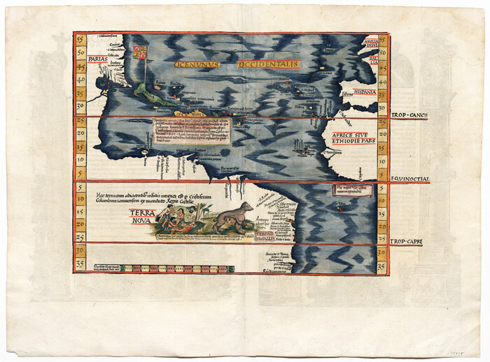
[Oceani occidentalis seu terrae novae tabula]
Print $20.00
- Digital $50.00
[Oceani occidentalis seu terrae novae tabula]
1535
Size: 16.0 x 21.6 inches
95835
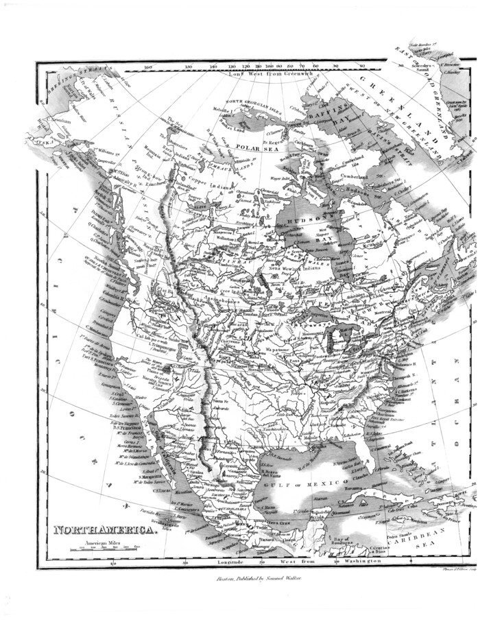
[Map of] North America
Print $3.00
- Digital $50.00
[Map of] North America
1834
Size: 11.0 x 8.5 inches
88884
Western Hemisphere

Print $20.00
- Digital $50.00
Western Hemisphere
1885
Size: 12.2 x 9.0 inches
93510
Travels to the source of the Missouri River and across the American Continent to the Pacific Ocean - Vol. 3

Travels to the source of the Missouri River and across the American Continent to the Pacific Ocean - Vol. 3
1815
97414
Travels to the source of the Missouri River and across the American Continent to the Pacific Ocean - Vol. 2

Travels to the source of the Missouri River and across the American Continent to the Pacific Ocean - Vol. 2
1815
97413
Travels to the source of the Missouri River and across the American Continent to the Pacific Ocean - Vol. 1

Travels to the source of the Missouri River and across the American Continent to the Pacific Ocean - Vol. 1
1815
97411
The United States of North America with the British Territories and Those of Spain, according to the Treaty of 1784

Print $20.00
- Digital $50.00
The United States of North America with the British Territories and Those of Spain, according to the Treaty of 1784
1796
Size: 23.6 x 30.8 inches
95738
The North Part of America Conteyning Newfoundland, New England, Virginia, Florida, New Spaine, and Nova Francia

Print $20.00
- Digital $50.00
The North Part of America Conteyning Newfoundland, New England, Virginia, Florida, New Spaine, and Nova Francia
1625
Size: 12.6 x 16.2 inches
97028
The North Part of America

Print $20.00
- Digital $50.00
The North Part of America
1625
Size: 13.1 x 14.8 inches
93815
The Dawn of Humans Peopling of the Americas

The Dawn of Humans Peopling of the Americas
2000
Size: 31.3 x 20.5 inches
96841

The American Military Pocket Atlas; being an approved Collection of Correct Maps, both general and particular, of the British Colonies; Especially those which now are, or probably may be the Theatre of War

The American Military Pocket Atlas; being an approved Collection of Correct Maps, both general and particular, of the British Colonies; Especially those which now are, or probably may be the Theatre of War
1776
97398
Terre Nove (verso)

Print $20.00
- Digital $50.00
Terre Nove (verso)
1522
Size: 12.2 x 7.8 inches
93802
Tabula Terre Nove

Print $20.00
- Digital $50.00
Tabula Terre Nove
1513
Size: 18.7 x 24.6 inches
93800
Spanish North America

Print $20.00
- Digital $50.00
Spanish North America
1814
Size: 21.9 x 29.8 inches
89224
Spanish Dominions in North America, Northern Part

Print $20.00
- Digital $50.00
Spanish Dominions in North America, Northern Part
1811
Size: 22.1 x 30.5 inches
95133
Regni Mexicani seu Novae Hispaniae, Ludovicianae, N. Angliae, Carolinae, Virginiae, et Pennsylvaniae

Print $20.00
- Digital $50.00
Regni Mexicani seu Novae Hispaniae, Ludovicianae, N. Angliae, Carolinae, Virginiae, et Pennsylvaniae
1720
Size: 22.5 x 26.5 inches
93408
Qvivirae Regnv, cum alijs verfus Borea

Print $20.00
- Digital $50.00
Qvivirae Regnv, cum alijs verfus Borea
1593
Size: 16.7 x 11.7 inches
93833
Qvarte Partie Dv Monde

Print $20.00
- Digital $50.00
Qvarte Partie Dv Monde
1575
Size: 15.3 x 18.9 inches
93806
Partie Meridionale de la Riviere de Missisipi, et ses environs dans l'Amerique Septentrionale

Print $20.00
- Digital $50.00
Partie Meridionale de la Riviere de Missisipi, et ses environs dans l'Amerique Septentrionale
1718
Size: 22.0 x 30.3 inches
93926
Nuevo Mapa Geographico de la America Septentrional, Perteneciente al Virreynato de Mexico

Print $20.00
- Digital $50.00
Nuevo Mapa Geographico de la America Septentrional, Perteneciente al Virreynato de Mexico
1768
Size: 23.1 x 30.3 inches
93835
Novissima et Accuratissima Totius Americae Descriptio

Print $20.00
- Digital $50.00
Novissima et Accuratissima Totius Americae Descriptio
1677
Size: 20.9 x 25.0 inches
93819
Nova et Acurata Totius Americae Tabula

Print $40.00
Nova et Acurata Totius Americae Tabula
1608
Size: 40.8 x 56.5 inches
97019
Nova Totivs Americae Descriptio

Print $20.00
- Digital $50.00
Nova Totivs Americae Descriptio
1666
Size: 21.2 x 24.3 inches
93818
North American Territorial Claims and the Treaty of Paris

North American Territorial Claims and the Treaty of Paris
2025
Size: 11.0 x 17.0 inches
97453

North America, as divided amongst the European Powers

Print $20.00
- Digital $50.00
North America, as divided amongst the European Powers
1774
Size: 14.1 x 18.7 inches
97399
North America in the Age of Dinosaurs

North America in the Age of Dinosaurs
1993
Size: 27.4 x 20.8 inches
96831
North America corrected from the observations communicated to the Royal Society at London and the Royal Academy at Paris

Print $20.00
- Digital $50.00
North America corrected from the observations communicated to the Royal Society at London and the Royal Academy at Paris
1710
Size: 38.9 x 26.9 inches
93820
[Oceani occidentalis seu terrae novae tabula]
Print $20.00
- Digital $50.00
[Oceani occidentalis seu terrae novae tabula]
1535
-
Size
16.0 x 21.6 inches
-
Map/Doc
95835
-
Creation Date
1535
[Map of] North America
Print $3.00
- Digital $50.00
[Map of] North America
1834
-
Size
11.0 x 8.5 inches
-
Map/Doc
88884
-
Creation Date
1834
Western Hemisphere
Print $20.00
- Digital $50.00
Western Hemisphere
1885
-
Size
12.2 x 9.0 inches
-
Map/Doc
93510
-
Creation Date
1885
Travels to the source of the Missouri River and across the American Continent to the Pacific Ocean - Vol. 3
Travels to the source of the Missouri River and across the American Continent to the Pacific Ocean - Vol. 3
1815
-
Map/Doc
97414
-
Creation Date
1815
Travels to the source of the Missouri River and across the American Continent to the Pacific Ocean - Vol. 2
Travels to the source of the Missouri River and across the American Continent to the Pacific Ocean - Vol. 2
1815
-
Map/Doc
97413
-
Creation Date
1815
Travels to the source of the Missouri River and across the American Continent to the Pacific Ocean - Vol. 1
Travels to the source of the Missouri River and across the American Continent to the Pacific Ocean - Vol. 1
1815
-
Map/Doc
97411
-
Creation Date
1815
The United States of North America with the British Territories and Those of Spain, according to the Treaty of 1784
Print $20.00
- Digital $50.00
The United States of North America with the British Territories and Those of Spain, according to the Treaty of 1784
1796
-
Size
23.6 x 30.8 inches
-
Map/Doc
95738
-
Creation Date
1796
The North Part of America Conteyning Newfoundland, New England, Virginia, Florida, New Spaine, and Nova Francia
Print $20.00
- Digital $50.00
The North Part of America Conteyning Newfoundland, New England, Virginia, Florida, New Spaine, and Nova Francia
1625
-
Size
12.6 x 16.2 inches
-
Map/Doc
97028
-
Creation Date
1625
The North Part of America
Print $20.00
- Digital $50.00
The North Part of America
1625
-
Size
13.1 x 14.8 inches
-
Map/Doc
93815
-
Creation Date
1625
The Dawn of Humans Peopling of the Americas
The Dawn of Humans Peopling of the Americas
2000
-
Size
31.3 x 20.5 inches
-
Map/Doc
96841
-
Creation Date
2000
The American Military Pocket Atlas; being an approved Collection of Correct Maps, both general and particular, of the British Colonies; Especially those which now are, or probably may be the Theatre of War
The American Military Pocket Atlas; being an approved Collection of Correct Maps, both general and particular, of the British Colonies; Especially those which now are, or probably may be the Theatre of War
1776
-
Map/Doc
97398
-
Creation Date
1776
Terre Nove (verso)
Print $20.00
- Digital $50.00
Terre Nove (verso)
1522
-
Size
12.2 x 7.8 inches
-
Map/Doc
93802
-
Creation Date
1522
Terre Nove

Print $20.00
- Digital $50.00
Terre Nove
1522
-
Size
13.2 x 18.5 inches
-
Map/Doc
93801
-
Creation Date
1522
Tabula Terre Nove
Print $20.00
- Digital $50.00
Tabula Terre Nove
1513
-
Size
18.7 x 24.6 inches
-
Map/Doc
93800
-
Creation Date
1513
Spanish North America
Print $20.00
- Digital $50.00
Spanish North America
1814
-
Size
21.9 x 29.8 inches
-
Map/Doc
89224
-
Creation Date
1814
Spanish Dominions in North America, Northern Part
Print $20.00
- Digital $50.00
Spanish Dominions in North America, Northern Part
1811
-
Size
22.1 x 30.5 inches
-
Map/Doc
95133
-
Creation Date
1811
Regni Mexicani seu Novae Hispaniae, Ludovicianae, N. Angliae, Carolinae, Virginiae, et Pennsylvaniae
Print $20.00
- Digital $50.00
Regni Mexicani seu Novae Hispaniae, Ludovicianae, N. Angliae, Carolinae, Virginiae, et Pennsylvaniae
1720
-
Size
22.5 x 26.5 inches
-
Map/Doc
93408
-
Creation Date
1720
Qvivirae Regnv, cum alijs verfus Borea
Print $20.00
- Digital $50.00
Qvivirae Regnv, cum alijs verfus Borea
1593
-
Size
16.7 x 11.7 inches
-
Map/Doc
93833
-
Creation Date
1593
Qvarte Partie Dv Monde
Print $20.00
- Digital $50.00
Qvarte Partie Dv Monde
1575
-
Size
15.3 x 18.9 inches
-
Map/Doc
93806
-
Creation Date
1575
Partie Meridionale de la Riviere de Missisipi, et ses environs dans l'Amerique Septentrionale
Print $20.00
- Digital $50.00
Partie Meridionale de la Riviere de Missisipi, et ses environs dans l'Amerique Septentrionale
1718
-
Size
22.0 x 30.3 inches
-
Map/Doc
93926
-
Creation Date
1718
Nuevo Mapa Geographico de la America Septentrional, Perteneciente al Virreynato de Mexico
Print $20.00
- Digital $50.00
Nuevo Mapa Geographico de la America Septentrional, Perteneciente al Virreynato de Mexico
1768
-
Size
23.1 x 30.3 inches
-
Map/Doc
93835
-
Creation Date
1768
Novissima et Accuratissima Totius Americae Descriptio
Print $20.00
- Digital $50.00
Novissima et Accuratissima Totius Americae Descriptio
1677
-
Size
20.9 x 25.0 inches
-
Map/Doc
93819
-
Creation Date
1677
Nova et Acurata Totius Americae Tabula
Print $40.00
Nova et Acurata Totius Americae Tabula
1608
This map is an anonymous version of Blaeu's map of 1608 published in Venice in 1646.
-
Size
40.8 x 56.5 inches
-
Map/Doc
97019
-
Creation Date
1608
Nova Totivs Americae Descriptio
Print $20.00
- Digital $50.00
Nova Totivs Americae Descriptio
1666
-
Size
21.2 x 24.3 inches
-
Map/Doc
93818
-
Creation Date
1666
North American Territorial Claims and the Treaty of Paris
North American Territorial Claims and the Treaty of Paris
2025
-
Size
11.0 x 17.0 inches
-
Map/Doc
97453
-
Creation Date
2025
North America, as divided amongst the European Powers
Print $20.00
- Digital $50.00
North America, as divided amongst the European Powers
1774
-
Size
14.1 x 18.7 inches
-
Map/Doc
97399
-
Creation Date
1774
North America in the Age of Dinosaurs
North America in the Age of Dinosaurs
1993
-
Size
27.4 x 20.8 inches
-
Map/Doc
96831
-
Creation Date
1993
North America corrected from the observations communicated to the Royal Society at London and the Royal Academy at Paris
Print $20.00
- Digital $50.00
North America corrected from the observations communicated to the Royal Society at London and the Royal Academy at Paris
1710
-
Size
38.9 x 26.9 inches
-
Map/Doc
93820
-
Creation Date
1710