Americae nova Tabula

Print $20.00
- Digital $50.00
Americae nova Tabula
1635
Size: 18.4 x 24.3 inches
93812
Colton's Map of United States, the Canadas & c. showing the Railraods, Canals & Stage Roads with distances from place to place

Print $20.00
- Digital $50.00
Colton's Map of United States, the Canadas & c. showing the Railraods, Canals & Stage Roads with distances from place to place
Size: 28.8 x 33.0 inches
93983
Geological Map of the United States and the British Provinces of North America

Print $20.00
- Digital $50.00
Geological Map of the United States and the British Provinces of North America
Size: 23.4 x 35.9 inches
93988
A New Map of the Whole Continent of America. Divided into North and South and West Indies, wherein are exactly decribed the United States of North America as well as the Several European Possessions according to the Preliminaries of Peace…

Print $40.00
- Digital $50.00
A New Map of the Whole Continent of America. Divided into North and South and West Indies, wherein are exactly decribed the United States of North America as well as the Several European Possessions according to the Preliminaries of Peace…
Size: 22.0 x 48.3 inches
95135
A New Map of the Whole Continent of America. Divided into North and South and West Indies, wherein are exactly decribed the United States of North America as well as the Several European Possessions according to the Preliminaries of Peace…

Print $40.00
- Digital $50.00
A New Map of the Whole Continent of America. Divided into North and South and West Indies, wherein are exactly decribed the United States of North America as well as the Several European Possessions according to the Preliminaries of Peace…
Size: 22.0 x 48.7 inches
95136
A New Map of the Whole Continent of America. Divided into North and South and West Indies, wherein are exactly decribed the United States of North America as well as the Several European Possessions according to the Preliminaries of Peace…

Print $40.00
- Digital $50.00
A New Map of the Whole Continent of America. Divided into North and South and West Indies, wherein are exactly decribed the United States of North America as well as the Several European Possessions according to the Preliminaries of Peace…
Size: 42.8 x 48.8 inches
95137

Canada, United States of America, Estados Unidos Mexicanos

Print $20.00
- Digital $50.00
Canada, United States of America, Estados Unidos Mexicanos
Size: 41.9 x 36.1 inches
96512
Carte d'un Nouveau Monde, entre le Nouveau Mexique, et la Mer Glacialle

Print $20.00
- Digital $50.00
Carte d'un Nouveau Monde, entre le Nouveau Mexique, et la Mer Glacialle
1698
Size: 11.5 x 18.1 inches
96555
Tabula Terre Nove

Print $20.00
- Digital $50.00
Tabula Terre Nove
1513
Size: 18.7 x 24.6 inches
93800
Terre Nove (verso)

Print $20.00
- Digital $50.00
Terre Nove (verso)
1522
Size: 12.2 x 7.8 inches
93802
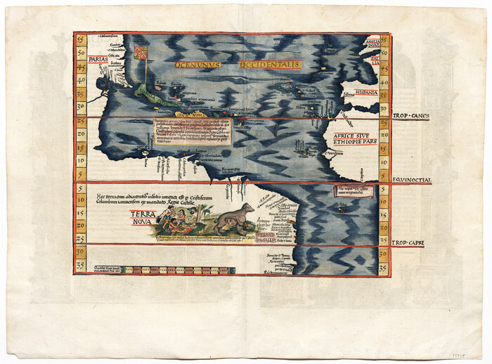
[Oceani occidentalis seu terrae novae tabula]
Print $20.00
- Digital $50.00
[Oceani occidentalis seu terrae novae tabula]
1535
Size: 16.0 x 21.6 inches
95835
Die Neüwen Inseln / so hinder Hispanien gegen Orient bey dem Landt Indie ligen

Print $20.00
- Digital $50.00
Die Neüwen Inseln / so hinder Hispanien gegen Orient bey dem Landt Indie ligen
1540
Size: 12.3 x 15.6 inches
93803
Die Neüwen Inseln / so hinder Hispanien gegen Orient bey dem Landt Indie ligen

Print $20.00
- Digital $50.00
Die Neüwen Inseln / so hinder Hispanien gegen Orient bey dem Landt Indie ligen
1540
Size: 10.8 x 15.8 inches
93831
La table des isles neufues, lesquelles on appelle isles d'occident & d'Indie pour divers regardz

Print $20.00
- Digital $50.00
La table des isles neufues, lesquelles on appelle isles d'occident & d'Indie pour divers regardz
1552
Size: 12.3 x 15.7 inches
95836
Il Disegno del discoperto della nova Franza, il quale se havuto ultimamente dalla novissima navigatione dè Francesi in quel luogo

Print $20.00
- Digital $50.00
Il Disegno del discoperto della nova Franza, il quale se havuto ultimamente dalla novissima navigatione dè Francesi in quel luogo
1566
Size: 12.6 x 18.6 inches
93804
Americae Sive Novi Orbis, Nova Descriptio

Print $20.00
- Digital $50.00
Americae Sive Novi Orbis, Nova Descriptio
1573
Size: 15.6 x 22.3 inches
95834
Qvarte Partie Dv Monde

Print $20.00
- Digital $50.00
Qvarte Partie Dv Monde
1575
Size: 15.3 x 18.9 inches
93806
Americae Sive Novi Orbis Nova Descriptio

Print $20.00
- Digital $50.00
Americae Sive Novi Orbis Nova Descriptio
1579
Size: 18.0 x 22.9 inches
93805
La Florida / Peruviae Avriferæ Regionis Typus / Guastecan

Print $20.00
- Digital $50.00
La Florida / Peruviae Avriferæ Regionis Typus / Guastecan
1584
Size: 16.8 x 20.9 inches
94100
America siue India Nova ad magnae Gerardi Mercatoris aui Vniversalis imitationem in compendium redacta

Print $20.00
- Digital $50.00
America siue India Nova ad magnae Gerardi Mercatoris aui Vniversalis imitationem in compendium redacta
1585
Size: 16.9 x 20.2 inches
93808
Americae Pars Borealis, Florida, Baccalaos, Canada, Corterealis

Print $20.00
- Digital $50.00
Americae Pars Borealis, Florida, Baccalaos, Canada, Corterealis
1593
Size: 16.2 x 22.1 inches
93832
Qvivirae Regnv, cum alijs verfus Borea

Print $20.00
- Digital $50.00
Qvivirae Regnv, cum alijs verfus Borea
1593
Size: 16.7 x 11.7 inches
93833
America siue India Nova ad magnae Gerardi Mercatoris aui Vniversalis imitationem in compendium redacta

Print $20.00
- Digital $50.00
America siue India Nova ad magnae Gerardi Mercatoris aui Vniversalis imitationem in compendium redacta
1595
Size: 18.3 x 21.6 inches
93807
America sive novvs orbis respectv evropaeorvm inferior globi terrestris pars 1596

Print $20.00
- Digital $50.00
America sive novvs orbis respectv evropaeorvm inferior globi terrestris pars 1596
1596
Size: 14.7 x 18.1 inches
93809
Florida et Apalche

Print $20.00
- Digital $50.00
Florida et Apalche
1597
Size: 11.2 x 14.4 inches
94076
Descripçion de las Yndias del Norte

Print $20.00
- Digital $50.00
Descripçion de las Yndias del Norte
1601
Size: 11.4 x 13.9 inches
94850
Descripcion de las Yndias Ocidentales

Print $20.00
- Digital $50.00
Descripcion de las Yndias Ocidentales
1601
Size: 9.6 x 13.2 inches
95962
Americae Sive Novi Orbis Nova Descriptio

Print $20.00
- Digital $50.00
Americae Sive Novi Orbis Nova Descriptio
1606
Size: 16.5 x 22.4 inches
93810
Americae nova Tabula
Print $20.00
- Digital $50.00
Americae nova Tabula
1635
-
Size
18.4 x 24.3 inches
-
Map/Doc
93812
-
Creation Date
1635
Colton's Map of United States, the Canadas & c. showing the Railraods, Canals & Stage Roads with distances from place to place
Print $20.00
- Digital $50.00
Colton's Map of United States, the Canadas & c. showing the Railraods, Canals & Stage Roads with distances from place to place
-
Size
28.8 x 33.0 inches
-
Map/Doc
93983
Geological Map of the United States and the British Provinces of North America
Print $20.00
- Digital $50.00
Geological Map of the United States and the British Provinces of North America
-
Size
23.4 x 35.9 inches
-
Map/Doc
93988
A New Map of the Whole Continent of America. Divided into North and South and West Indies, wherein are exactly decribed the United States of North America as well as the Several European Possessions according to the Preliminaries of Peace…
Print $40.00
- Digital $50.00
A New Map of the Whole Continent of America. Divided into North and South and West Indies, wherein are exactly decribed the United States of North America as well as the Several European Possessions according to the Preliminaries of Peace…
-
Size
22.0 x 48.3 inches
-
Map/Doc
95135
A New Map of the Whole Continent of America. Divided into North and South and West Indies, wherein are exactly decribed the United States of North America as well as the Several European Possessions according to the Preliminaries of Peace…
Print $40.00
- Digital $50.00
A New Map of the Whole Continent of America. Divided into North and South and West Indies, wherein are exactly decribed the United States of North America as well as the Several European Possessions according to the Preliminaries of Peace…
-
Size
22.0 x 48.7 inches
-
Map/Doc
95136
A New Map of the Whole Continent of America. Divided into North and South and West Indies, wherein are exactly decribed the United States of North America as well as the Several European Possessions according to the Preliminaries of Peace…
Print $40.00
- Digital $50.00
A New Map of the Whole Continent of America. Divided into North and South and West Indies, wherein are exactly decribed the United States of North America as well as the Several European Possessions according to the Preliminaries of Peace…
-
Size
42.8 x 48.8 inches
-
Map/Doc
95137
Canada, United States of America, Estados Unidos Mexicanos
Print $20.00
- Digital $50.00
Canada, United States of America, Estados Unidos Mexicanos
-
Size
41.9 x 36.1 inches
-
Map/Doc
96512
Carte d'un Nouveau Monde, entre le Nouveau Mexique, et la Mer Glacialle
Print $20.00
- Digital $50.00
Carte d'un Nouveau Monde, entre le Nouveau Mexique, et la Mer Glacialle
1698
-
Size
11.5 x 18.1 inches
-
Map/Doc
96555
-
Creation Date
1698
Tabula Terre Nove
Print $20.00
- Digital $50.00
Tabula Terre Nove
1513
-
Size
18.7 x 24.6 inches
-
Map/Doc
93800
-
Creation Date
1513
Terre Nove

Print $20.00
- Digital $50.00
Terre Nove
1522
-
Size
13.2 x 18.5 inches
-
Map/Doc
93801
-
Creation Date
1522
Terre Nove (verso)
Print $20.00
- Digital $50.00
Terre Nove (verso)
1522
-
Size
12.2 x 7.8 inches
-
Map/Doc
93802
-
Creation Date
1522
[Oceani occidentalis seu terrae novae tabula]
Print $20.00
- Digital $50.00
[Oceani occidentalis seu terrae novae tabula]
1535
-
Size
16.0 x 21.6 inches
-
Map/Doc
95835
-
Creation Date
1535
Die Neüwen Inseln / so hinder Hispanien gegen Orient bey dem Landt Indie ligen
Print $20.00
- Digital $50.00
Die Neüwen Inseln / so hinder Hispanien gegen Orient bey dem Landt Indie ligen
1540
-
Size
12.3 x 15.6 inches
-
Map/Doc
93803
-
Creation Date
1540
Die Neüwen Inseln / so hinder Hispanien gegen Orient bey dem Landt Indie ligen
Print $20.00
- Digital $50.00
Die Neüwen Inseln / so hinder Hispanien gegen Orient bey dem Landt Indie ligen
1540
-
Size
10.8 x 15.8 inches
-
Map/Doc
93831
-
Creation Date
1540
La table des isles neufues, lesquelles on appelle isles d'occident & d'Indie pour divers regardz
Print $20.00
- Digital $50.00
La table des isles neufues, lesquelles on appelle isles d'occident & d'Indie pour divers regardz
1552
-
Size
12.3 x 15.7 inches
-
Map/Doc
95836
-
Creation Date
1552
Il Disegno del discoperto della nova Franza, il quale se havuto ultimamente dalla novissima navigatione dè Francesi in quel luogo
Print $20.00
- Digital $50.00
Il Disegno del discoperto della nova Franza, il quale se havuto ultimamente dalla novissima navigatione dè Francesi in quel luogo
1566
-
Size
12.6 x 18.6 inches
-
Map/Doc
93804
-
Creation Date
1566
Americae Sive Novi Orbis, Nova Descriptio
Print $20.00
- Digital $50.00
Americae Sive Novi Orbis, Nova Descriptio
1573
-
Size
15.6 x 22.3 inches
-
Map/Doc
95834
-
Creation Date
1573
Qvarte Partie Dv Monde
Print $20.00
- Digital $50.00
Qvarte Partie Dv Monde
1575
-
Size
15.3 x 18.9 inches
-
Map/Doc
93806
-
Creation Date
1575
Americae Sive Novi Orbis Nova Descriptio
Print $20.00
- Digital $50.00
Americae Sive Novi Orbis Nova Descriptio
1579
-
Size
18.0 x 22.9 inches
-
Map/Doc
93805
-
Creation Date
1579
La Florida / Peruviae Avriferæ Regionis Typus / Guastecan
Print $20.00
- Digital $50.00
La Florida / Peruviae Avriferæ Regionis Typus / Guastecan
1584
-
Size
16.8 x 20.9 inches
-
Map/Doc
94100
-
Creation Date
1584
America siue India Nova ad magnae Gerardi Mercatoris aui Vniversalis imitationem in compendium redacta
Print $20.00
- Digital $50.00
America siue India Nova ad magnae Gerardi Mercatoris aui Vniversalis imitationem in compendium redacta
1585
-
Size
16.9 x 20.2 inches
-
Map/Doc
93808
-
Creation Date
1585
Americae Pars Borealis, Florida, Baccalaos, Canada, Corterealis
Print $20.00
- Digital $50.00
Americae Pars Borealis, Florida, Baccalaos, Canada, Corterealis
1593
-
Size
16.2 x 22.1 inches
-
Map/Doc
93832
-
Creation Date
1593
Qvivirae Regnv, cum alijs verfus Borea
Print $20.00
- Digital $50.00
Qvivirae Regnv, cum alijs verfus Borea
1593
-
Size
16.7 x 11.7 inches
-
Map/Doc
93833
-
Creation Date
1593
America siue India Nova ad magnae Gerardi Mercatoris aui Vniversalis imitationem in compendium redacta
Print $20.00
- Digital $50.00
America siue India Nova ad magnae Gerardi Mercatoris aui Vniversalis imitationem in compendium redacta
1595
-
Size
18.3 x 21.6 inches
-
Map/Doc
93807
-
Creation Date
1595
America sive novvs orbis respectv evropaeorvm inferior globi terrestris pars 1596
Print $20.00
- Digital $50.00
America sive novvs orbis respectv evropaeorvm inferior globi terrestris pars 1596
1596
-
Size
14.7 x 18.1 inches
-
Map/Doc
93809
-
Creation Date
1596
Florida et Apalche
Print $20.00
- Digital $50.00
Florida et Apalche
1597
-
Size
11.2 x 14.4 inches
-
Map/Doc
94076
-
Creation Date
1597
Descripçion de las Yndias del Norte
Print $20.00
- Digital $50.00
Descripçion de las Yndias del Norte
1601
-
Size
11.4 x 13.9 inches
-
Map/Doc
94850
-
Creation Date
1601
Descripcion de las Yndias Ocidentales
Print $20.00
- Digital $50.00
Descripcion de las Yndias Ocidentales
1601
-
Size
9.6 x 13.2 inches
-
Map/Doc
95962
-
Creation Date
1601
Americae Sive Novi Orbis Nova Descriptio
Print $20.00
- Digital $50.00
Americae Sive Novi Orbis Nova Descriptio
1606
-
Size
16.5 x 22.4 inches
-
Map/Doc
93810
-
Creation Date
1606