Mappa Geographica Regionem Mexicanam et Floridam, Terrasque adjacentes, ut et Anteriores Americae Insulas, Curfus itidem et Reditus Navigantuim verfus flumen Missisipi et alias Colonias ob oculos ponens, cura et fumptibus

Print $20.00
Mappa Geographica Regionem Mexicanam et Floridam, Terrasque adjacentes, ut et Anteriores Americae Insulas, Curfus itidem et Reditus Navigantuim verfus flumen Missisipi et alias Colonias ob oculos ponens, cura et fumptibus
1725
Size: 20.0 x 24.0 inches
76196
A Map of Louisiana and Mexico

Print $20.00
A Map of Louisiana and Mexico
1820
Size: 43.0 x 32.6 inches
76218
A Chart of the Internal Part of Louisiana

Print $20.00
A Chart of the Internal Part of Louisiana
1807
Size: 19.2 x 16.5 inches
79310
Mappa Geographica Americae Septentrionalis: ad emendatiora exemplaria adhuc edita jussu Acad. Reg. Scient. Et eleg. Litt. Descripta.

Print $20.00
- Digital $50.00
Mappa Geographica Americae Septentrionalis: ad emendatiora exemplaria adhuc edita jussu Acad. Reg. Scient. Et eleg. Litt. Descripta.
1753
Size: 14.9 x 17.4 inches
88882
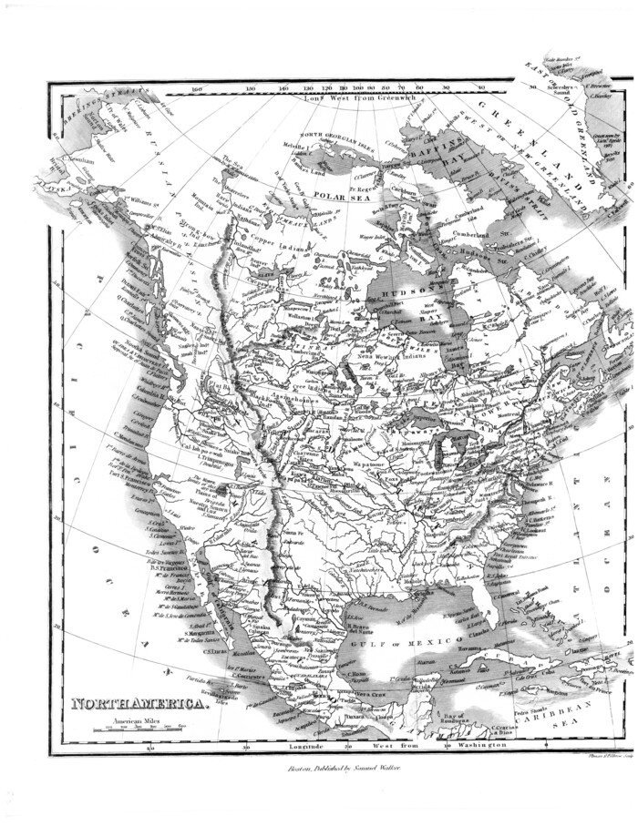
[Map of] North America
Print $3.00
- Digital $50.00
[Map of] North America
1834
Size: 11.0 x 8.5 inches
88884
Carte de la Louisiane et du Cours du Mississipi

Print $20.00
Carte de la Louisiane et du Cours du Mississipi
1718
Size: 16.6 x 21.8 inches
89216
Carta Geografica Della Florida Nell America Settentrionale

Print $20.00
- Digital $50.00
Carta Geografica Della Florida Nell America Settentrionale
1740
Size: 14.1 x 18.5 inches
89222
Spanish North America

Print $20.00
- Digital $50.00
Spanish North America
1814
Size: 21.9 x 29.8 inches
89224

Regni Mexicani seu Novae Hispaniae, Ludovicianae, N. Angliae, Carolinae, Virginiae, et Pennsylvaniae

Print $20.00
- Digital $50.00
Regni Mexicani seu Novae Hispaniae, Ludovicianae, N. Angliae, Carolinae, Virginiae, et Pennsylvaniae
1720
Size: 22.5 x 26.5 inches
93408
Carte du Mexique et des Pays Limitrophes Situés au Nord et à l'Est

Print $20.00
- Digital $50.00
Carte du Mexique et des Pays Limitrophes Situés au Nord et à l'Est
1811
Size: 17.5 x 29.0 inches
93421
Map of North America engraved to illustrate Mitchell's school and family geography

Print $20.00
- Digital $50.00
Map of North America engraved to illustrate Mitchell's school and family geography
1839
Size: 11.8 x 9.5 inches
93493
Western Hemisphere

Print $20.00
- Digital $50.00
Western Hemisphere
1885
Size: 12.2 x 9.0 inches
93510
Map of North America engraved to illustrate Mitchell's new intermediate geography

Print $20.00
- Digital $50.00
Map of North America engraved to illustrate Mitchell's new intermediate geography
1885
Size: 12.2 x 9.0 inches
93512
Map of North America to illustrate Olney's school geography

Print $20.00
- Digital $50.00
Map of North America to illustrate Olney's school geography
1844
Size: 12.1 x 9.3 inches
93536
Map of North America engraved to illustrate Mitchell's school and family geography

Print $20.00
Map of North America engraved to illustrate Mitchell's school and family geography
1839
Size: 11.3 x 8.7 inches
93552
Carte Generale des Treize Etats-Unis de l'Amerique Septentrionale

Print $20.00
- Digital $50.00
Carte Generale des Treize Etats-Unis de l'Amerique Septentrionale
1783
Size: 22.9 x 27.0 inches
93678
A New and Accurate Map of Louisiana with parts of Florida and Canada and the Adjacent Countries

Print $20.00
- Digital $50.00
A New and Accurate Map of Louisiana with parts of Florida and Canada and the Adjacent Countries
1747
Size: 15.8 x 18.6 inches
93680
Amerique Septentrionale

Print $20.00
- Digital $50.00
Amerique Septentrionale
1650
Size: 17.2 x 23.1 inches
93684
America Settentrionale colle nuove scoperte fin all’anno 1688

Print $20.00
- Digital $50.00
America Settentrionale colle nuove scoperte fin all’anno 1688
1688
Size: 29.7 x 37.5 inches
93709
Bowles's New Pocket Map of North America, divided into it's Provinces, Colonies, &c.

Print $20.00
- Digital $50.00
Bowles's New Pocket Map of North America, divided into it's Provinces, Colonies, &c.
1776
Size: 21.8 x 29.0 inches
93732
A Map of the British Empire in North America

Print $20.00
- Digital $50.00
A Map of the British Empire in North America
1774
Size: 22.1 x 15.1 inches
93733
A New Map of North America with the West India Islands divided according to the preliminary Articles of Peace, signed at Versailles, 20 Jan. 1783

Print $40.00
- Digital $50.00
A New Map of North America with the West India Islands divided according to the preliminary Articles of Peace, signed at Versailles, 20 Jan. 1783
1794
Size: 42.1 x 48.4 inches
93734
Les costes aux environs de la Riviere de Misisipi decouvertes par M. de la Salle en 1683 et reconnues par M. le Chevallier d'Iberville en 1698 et 1699

Print $20.00
- Digital $50.00
Les costes aux environs de la Riviere de Misisipi decouvertes par M. de la Salle en 1683 et reconnues par M. le Chevallier d'Iberville en 1698 et 1699
1701
Size: 10.4 x 14.9 inches
93756
Amérique Septentrionale

Print $20.00
- Digital $50.00
Amérique Septentrionale
1845
Size: 14.2 x 21.0 inches
93780
Tabula Terre Nove

Print $20.00
- Digital $50.00
Tabula Terre Nove
1513
Size: 18.7 x 24.6 inches
93800
Terre Nove (verso)

Print $20.00
- Digital $50.00
Terre Nove (verso)
1522
Size: 12.2 x 7.8 inches
93802
Die Neüwen Inseln / so hinder Hispanien gegen Orient bey dem Landt Indie ligen

Print $20.00
- Digital $50.00
Die Neüwen Inseln / so hinder Hispanien gegen Orient bey dem Landt Indie ligen
1540
Size: 12.3 x 15.6 inches
93803
Il Disegno del discoperto della nova Franza, il quale se havuto ultimamente dalla novissima navigatione dè Francesi in quel luogo

Print $20.00
- Digital $50.00
Il Disegno del discoperto della nova Franza, il quale se havuto ultimamente dalla novissima navigatione dè Francesi in quel luogo
1566
Size: 12.6 x 18.6 inches
93804
Mappa Geographica Regionem Mexicanam et Floridam, Terrasque adjacentes, ut et Anteriores Americae Insulas, Curfus itidem et Reditus Navigantuim verfus flumen Missisipi et alias Colonias ob oculos ponens, cura et fumptibus
Print $20.00
Mappa Geographica Regionem Mexicanam et Floridam, Terrasque adjacentes, ut et Anteriores Americae Insulas, Curfus itidem et Reditus Navigantuim verfus flumen Missisipi et alias Colonias ob oculos ponens, cura et fumptibus
1725
-
Size
20.0 x 24.0 inches
-
Map/Doc
76196
-
Creation Date
1725
A Map of Louisiana and Mexico
Print $20.00
A Map of Louisiana and Mexico
1820
-
Size
43.0 x 32.6 inches
-
Map/Doc
76218
-
Creation Date
1820
A Chart of the Internal Part of Louisiana
Print $20.00
A Chart of the Internal Part of Louisiana
1807
-
Size
19.2 x 16.5 inches
-
Map/Doc
79310
-
Creation Date
1807
Mappa Geographica Americae Septentrionalis: ad emendatiora exemplaria adhuc edita jussu Acad. Reg. Scient. Et eleg. Litt. Descripta.
Print $20.00
- Digital $50.00
Mappa Geographica Americae Septentrionalis: ad emendatiora exemplaria adhuc edita jussu Acad. Reg. Scient. Et eleg. Litt. Descripta.
1753
-
Size
14.9 x 17.4 inches
-
Map/Doc
88882
-
Creation Date
1753
[Map of] North America
Print $3.00
- Digital $50.00
[Map of] North America
1834
-
Size
11.0 x 8.5 inches
-
Map/Doc
88884
-
Creation Date
1834
Carte de la Louisiane et du Cours du Mississipi
Print $20.00
Carte de la Louisiane et du Cours du Mississipi
1718
-
Size
16.6 x 21.8 inches
-
Map/Doc
89216
-
Creation Date
1718
Carta Geografica Della Florida Nell America Settentrionale
Print $20.00
- Digital $50.00
Carta Geografica Della Florida Nell America Settentrionale
1740
-
Size
14.1 x 18.5 inches
-
Map/Doc
89222
-
Creation Date
1740
Spanish North America
Print $20.00
- Digital $50.00
Spanish North America
1814
-
Size
21.9 x 29.8 inches
-
Map/Doc
89224
-
Creation Date
1814
Regni Mexicani seu Novae Hispaniae, Ludovicianae, N. Angliae, Carolinae, Virginiae, et Pennsylvaniae
Print $20.00
- Digital $50.00
Regni Mexicani seu Novae Hispaniae, Ludovicianae, N. Angliae, Carolinae, Virginiae, et Pennsylvaniae
1720
-
Size
22.5 x 26.5 inches
-
Map/Doc
93408
-
Creation Date
1720
Carte du Mexique et des Pays Limitrophes Situés au Nord et à l'Est
Print $20.00
- Digital $50.00
Carte du Mexique et des Pays Limitrophes Situés au Nord et à l'Est
1811
-
Size
17.5 x 29.0 inches
-
Map/Doc
93421
-
Creation Date
1811
Map of North America engraved to illustrate Mitchell's school and family geography
Print $20.00
- Digital $50.00
Map of North America engraved to illustrate Mitchell's school and family geography
1839
-
Size
11.8 x 9.5 inches
-
Map/Doc
93493
-
Creation Date
1839
Western Hemisphere
Print $20.00
- Digital $50.00
Western Hemisphere
1885
-
Size
12.2 x 9.0 inches
-
Map/Doc
93510
-
Creation Date
1885
Map of North America engraved to illustrate Mitchell's new intermediate geography
Print $20.00
- Digital $50.00
Map of North America engraved to illustrate Mitchell's new intermediate geography
1885
-
Size
12.2 x 9.0 inches
-
Map/Doc
93512
-
Creation Date
1885
Map of North America to illustrate Olney's school geography
Print $20.00
- Digital $50.00
Map of North America to illustrate Olney's school geography
1844
-
Size
12.1 x 9.3 inches
-
Map/Doc
93536
-
Creation Date
1844
Map of North America engraved to illustrate Mitchell's school and family geography
Print $20.00
Map of North America engraved to illustrate Mitchell's school and family geography
1839
-
Size
11.3 x 8.7 inches
-
Map/Doc
93552
-
Creation Date
1839
Carte Generale des Treize Etats-Unis de l'Amerique Septentrionale
Print $20.00
- Digital $50.00
Carte Generale des Treize Etats-Unis de l'Amerique Septentrionale
1783
-
Size
22.9 x 27.0 inches
-
Map/Doc
93678
-
Creation Date
1783
A New and Accurate Map of Louisiana with parts of Florida and Canada and the Adjacent Countries
Print $20.00
- Digital $50.00
A New and Accurate Map of Louisiana with parts of Florida and Canada and the Adjacent Countries
1747
-
Size
15.8 x 18.6 inches
-
Map/Doc
93680
-
Creation Date
1747
Amerique Septentrionale
Print $20.00
- Digital $50.00
Amerique Septentrionale
1650
-
Size
17.2 x 23.1 inches
-
Map/Doc
93684
-
Creation Date
1650
America Settentrionale colle nuove scoperte fin all’anno 1688
Print $20.00
- Digital $50.00
America Settentrionale colle nuove scoperte fin all’anno 1688
1688
-
Size
29.7 x 37.5 inches
-
Map/Doc
93709
-
Creation Date
1688
Bowles's New Pocket Map of North America, divided into it's Provinces, Colonies, &c.
Print $20.00
- Digital $50.00
Bowles's New Pocket Map of North America, divided into it's Provinces, Colonies, &c.
1776
-
Size
21.8 x 29.0 inches
-
Map/Doc
93732
-
Creation Date
1776
A Map of the British Empire in North America
Print $20.00
- Digital $50.00
A Map of the British Empire in North America
1774
-
Size
22.1 x 15.1 inches
-
Map/Doc
93733
-
Creation Date
1774
A New Map of North America with the West India Islands divided according to the preliminary Articles of Peace, signed at Versailles, 20 Jan. 1783
Print $40.00
- Digital $50.00
A New Map of North America with the West India Islands divided according to the preliminary Articles of Peace, signed at Versailles, 20 Jan. 1783
1794
-
Size
42.1 x 48.4 inches
-
Map/Doc
93734
-
Creation Date
1794
Les costes aux environs de la Riviere de Misisipi decouvertes par M. de la Salle en 1683 et reconnues par M. le Chevallier d'Iberville en 1698 et 1699
Print $20.00
- Digital $50.00
Les costes aux environs de la Riviere de Misisipi decouvertes par M. de la Salle en 1683 et reconnues par M. le Chevallier d'Iberville en 1698 et 1699
1701
-
Size
10.4 x 14.9 inches
-
Map/Doc
93756
-
Creation Date
1701
Amérique Septentrionale
Print $20.00
- Digital $50.00
Amérique Septentrionale
1845
-
Size
14.2 x 21.0 inches
-
Map/Doc
93780
-
Creation Date
1845
Tabula Terre Nove
Print $20.00
- Digital $50.00
Tabula Terre Nove
1513
-
Size
18.7 x 24.6 inches
-
Map/Doc
93800
-
Creation Date
1513
Terre Nove

Print $20.00
- Digital $50.00
Terre Nove
1522
-
Size
13.2 x 18.5 inches
-
Map/Doc
93801
-
Creation Date
1522
Terre Nove (verso)
Print $20.00
- Digital $50.00
Terre Nove (verso)
1522
-
Size
12.2 x 7.8 inches
-
Map/Doc
93802
-
Creation Date
1522
Die Neüwen Inseln / so hinder Hispanien gegen Orient bey dem Landt Indie ligen
Print $20.00
- Digital $50.00
Die Neüwen Inseln / so hinder Hispanien gegen Orient bey dem Landt Indie ligen
1540
-
Size
12.3 x 15.6 inches
-
Map/Doc
93803
-
Creation Date
1540
Il Disegno del discoperto della nova Franza, il quale se havuto ultimamente dalla novissima navigatione dè Francesi in quel luogo
Print $20.00
- Digital $50.00
Il Disegno del discoperto della nova Franza, il quale se havuto ultimamente dalla novissima navigatione dè Francesi in quel luogo
1566
-
Size
12.6 x 18.6 inches
-
Map/Doc
93804
-
Creation Date
1566