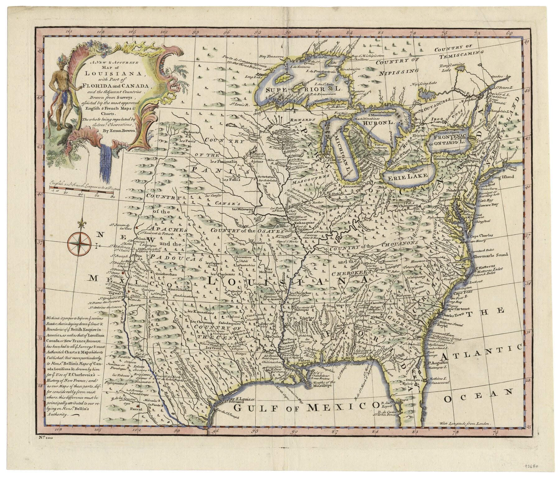
A New and Accurate Map of Louisiana with parts of Florida and Canada and the Adjacent Countries
-
Map/Doc
93680
-
Collection
General Map Collection
-
Object Dates
1747 (Creation Date)
2014/4/22 (File Date)
-
People and Organizations
[Emanuel] Bowen (Author)
-
Subjects
North America
-
Height x Width
15.8 x 18.6 inches
40.1 x 47.2 cm
-
Comments
Drawn from surveys assisted by the most approved English and French maps and charts.
-
URLs
https://medium.com/save-texas-history/a-new-accurate-map-of-louisiana-with-part-of-florida-and-canada-and-the-adjacent-countries-80c6e8b49ab6#.u4k065rsf
Part of: General Map Collection
Trinity County Sketch File 18 1/2

Print $4.00
- Digital $50.00
Trinity County Sketch File 18 1/2
1876
Size 9.0 x 11.2 inches
Map/Doc 38548
Hudspeth County Rolled Sketch 61

Print $40.00
- Digital $50.00
Hudspeth County Rolled Sketch 61
1982
Size 71.3 x 45.1 inches
Map/Doc 9626
Motley County Sketch File 4 (N)

Print $20.00
- Digital $50.00
Motley County Sketch File 4 (N)
1882
Size 18.3 x 20.8 inches
Map/Doc 42137
Panola County Working Sketch 24

Print $20.00
- Digital $50.00
Panola County Working Sketch 24
1957
Map/Doc 71433
Flight Mission No. DAG-26K, Frame 81, Matagorda County

Print $20.00
- Digital $50.00
Flight Mission No. DAG-26K, Frame 81, Matagorda County
1953
Size 18.5 x 22.2 inches
Map/Doc 86586
Flight Mission No. DQO-7K, Frame 80, Galveston County

Print $20.00
- Digital $50.00
Flight Mission No. DQO-7K, Frame 80, Galveston County
1952
Size 18.8 x 22.4 inches
Map/Doc 85107
Lubbock County Working Sketch 7

Print $20.00
- Digital $50.00
Lubbock County Working Sketch 7
1964
Size 21.9 x 25.3 inches
Map/Doc 70667
Stonewall County Working Sketch 29

Print $40.00
- Digital $50.00
Stonewall County Working Sketch 29
1979
Size 48.5 x 43.0 inches
Map/Doc 62336
Port Facilities at Houston, Tex.

Print $20.00
- Digital $50.00
Port Facilities at Houston, Tex.
1924
Size 14.1 x 30.3 inches
Map/Doc 97167
Jack County Working Sketch 3

Print $20.00
- Digital $50.00
Jack County Working Sketch 3
1940
Size 18.8 x 26.0 inches
Map/Doc 66429
La Salle County Rolled Sketch 11

Print $20.00
- Digital $50.00
La Salle County Rolled Sketch 11
1947
Size 22.1 x 35.8 inches
Map/Doc 6574

You may also like
Uvalde County Sketch File 18

Print $6.00
- Digital $50.00
Uvalde County Sketch File 18
1883
Size 10.9 x 8.2 inches
Map/Doc 38997
Crosby County Working Sketch 12

Print $20.00
- Digital $50.00
Crosby County Working Sketch 12
1953
Size 26.0 x 29.8 inches
Map/Doc 68446
Flight Mission No. BRE-2P, Frame 11, Nueces County

Print $20.00
- Digital $50.00
Flight Mission No. BRE-2P, Frame 11, Nueces County
1956
Size 18.6 x 22.7 inches
Map/Doc 86720
Marion County Rolled Sketch 8

Print $20.00
- Digital $50.00
Marion County Rolled Sketch 8
1998
Size 33.0 x 22.1 inches
Map/Doc 6661
Brazos County Working Sketch 4

Print $20.00
- Digital $50.00
Brazos County Working Sketch 4
1976
Size 22.5 x 20.6 inches
Map/Doc 67479
Revised map of the State of Texas

Print $20.00
- Digital $50.00
Revised map of the State of Texas
1876
Size 19.6 x 19.7 inches
Map/Doc 95755
Calhoun County Sketch File 12

Print $120.00
- Digital $50.00
Calhoun County Sketch File 12
Size 23.0 x 36.9 inches
Map/Doc 11033
Mitchell County Working Sketch 5

Print $40.00
- Digital $50.00
Mitchell County Working Sketch 5
1956
Size 60.4 x 28.2 inches
Map/Doc 71062
Map of Jones County West of the Clearfork of the Brazos River Young - East of it Milam - Land District

Print $20.00
- Digital $50.00
Map of Jones County West of the Clearfork of the Brazos River Young - East of it Milam - Land District
1859
Size 22.0 x 26.5 inches
Map/Doc 3741
Hemphill County Working Sketch 30

Print $40.00
- Digital $50.00
Hemphill County Working Sketch 30
1974
Size 52.5 x 26.7 inches
Map/Doc 66125
[Beaumont, Sour Lake and Western Ry. Right of Way and Alignment - Frisco]
![64127, [Beaumont, Sour Lake and Western Ry. Right of Way and Alignment - Frisco], General Map Collection](https://historictexasmaps.com/wmedia_w700/maps/64127.tif.jpg)
Print $20.00
- Digital $50.00
[Beaumont, Sour Lake and Western Ry. Right of Way and Alignment - Frisco]
1910
Size 20.1 x 45.8 inches
Map/Doc 64127
History of Texas from its First Settlement in 1685 to its Annexation to the United States in 1846 (Vol. 1)

History of Texas from its First Settlement in 1685 to its Annexation to the United States in 1846 (Vol. 1)
1856
Map/Doc 97390