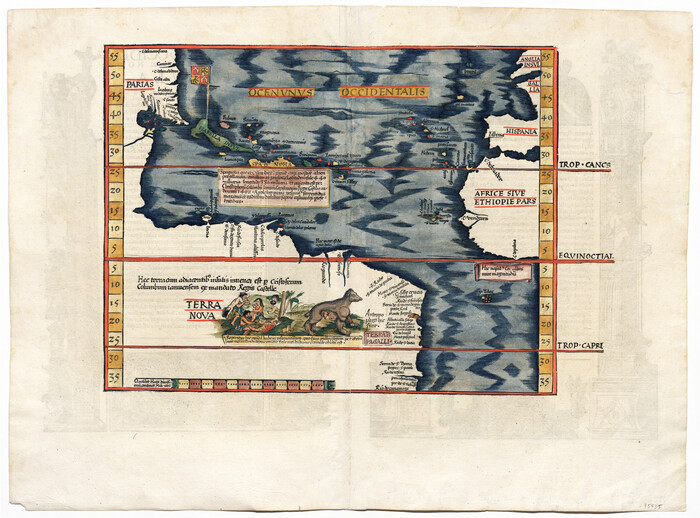
[Oceani occidentalis seu terrae novae tabula]
Print $20.00
- Digital $50.00
[Oceani occidentalis seu terrae novae tabula]
1535
Size: 16.0 x 21.6 inches
95835
Western Hemisphere

Print $20.00
- Digital $50.00
Western Hemisphere
1885
Size: 12.2 x 9.0 inches
93510
The Inca, Machu Picchu Salutes the Sun

The Inca, Machu Picchu Salutes the Sun
Size: 20.4 x 31.3 inches
95935
The Dawn of Humans Peopling of the Americas

The Dawn of Humans Peopling of the Americas
2000
Size: 31.3 x 20.5 inches
96841
The Continent and Islands of the West Indies

Print $20.00
The Continent and Islands of the West Indies
1804
Size: 22.8 x 26.0 inches
79318

Tabula Terre Nove

Print $20.00
- Digital $50.00
Tabula Terre Nove
1513
Size: 18.7 x 24.6 inches
93800

Qvarte Partie Dv Monde

Print $20.00
- Digital $50.00
Qvarte Partie Dv Monde
1575
Size: 15.3 x 18.9 inches
93806
Novissima et Accuratissima Totius Americae Descriptio

Print $20.00
- Digital $50.00
Novissima et Accuratissima Totius Americae Descriptio
1677
Size: 20.9 x 25.0 inches
93819
Nova et Acurata Totius Americae Tabula

Print $40.00
Nova et Acurata Totius Americae Tabula
1608
Size: 40.8 x 56.5 inches
97019
Nova Totivs Americae Descriptio

Print $20.00
- Digital $50.00
Nova Totivs Americae Descriptio
1666
Size: 21.2 x 24.3 inches
93818
Mexico, Regia et Celebris Hispaniae Novae Civitas [and] Cusco, Rengi Peru in Novo Orbe Casvt

Print $20.00
- Digital $50.00
Mexico, Regia et Celebris Hispaniae Novae Civitas [and] Cusco, Rengi Peru in Novo Orbe Casvt
1572
Size: 13.8 x 20.1 inches
97025
Map of the United States, the British Provinces, Mexico &c. Showing the Routes of the U.S. Mail Steam Packets to California and a Plan of the Gold Region

Print $20.00
- Digital $50.00
Map of the United States, the British Provinces, Mexico &c. Showing the Routes of the U.S. Mail Steam Packets to California and a Plan of the Gold Region
1849
Size: 19.6 x 26.6 inches
95695
Map of South America to illustrate Olney's school geography

Print $20.00
- Digital $50.00
Map of South America to illustrate Olney's school geography
1844
Size: 12.1 x 9.5 inches
93545
Map of South America engraved to illustrate Mitchell's school and family geography

Print $20.00
- Digital $50.00
Map of South America engraved to illustrate Mitchell's school and family geography
1839
Size: 11.8 x 9.5 inches
93501
Map of South America engraved to illustrate Mitchell's new intermediate geography

Print $20.00
- Digital $50.00
Map of South America engraved to illustrate Mitchell's new intermediate geography
1885
Size: 12.2 x 9.0 inches
93525
Map of South America designed to accompany Smith's Geography of Schools

Print $20.00
- Digital $50.00
Map of South America designed to accompany Smith's Geography of Schools
1850
Size: 12.0 x 9.8 inches
93891
La table des isles neufues, lesquelles on appelle isles d'occident & d'Indie pour divers regardz

Print $20.00
- Digital $50.00
La table des isles neufues, lesquelles on appelle isles d'occident & d'Indie pour divers regardz
1552
Size: 12.3 x 15.7 inches
95836
La Florida / Peruviae Avriferæ Regionis Typus / Guastecan

Print $20.00
- Digital $50.00
La Florida / Peruviae Avriferæ Regionis Typus / Guastecan
1584
Size: 16.8 x 20.9 inches
94100
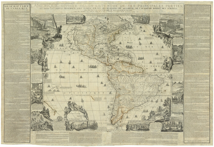
L'Amerique, divisée selon l[']etendue de ses principales parties, et dont les points principaux sont placez sur les observations de messieurs de l'Academie Royale des Sciences
Print $40.00
- Digital $50.00
L'Amerique, divisée selon l[']etendue de ses principales parties, et dont les points principaux sont placez sur les observations de messieurs de l'Academie Royale des Sciences
1705
Size: 44.9 x 65.4 inches
95688
L'Amerique divisée en ses principales parties où sont distingués les uns des autres les estats selon quils appartiennent presentement aux differents souverains de l'Europe

Print $20.00
- Digital $50.00
L'Amerique divisée en ses principales parties où sont distingués les uns des autres les estats selon quils appartiennent presentement aux differents souverains de l'Europe
1752
Size: 36.0 x 43.6 inches
95188
L'Amerique Meridionale, et Septentrionale Dressee selon les derniers Relations et suivant les Nouvelles Decouvertes

Print $20.00
- Digital $50.00
L'Amerique Meridionale, et Septentrionale Dressee selon les derniers Relations et suivant les Nouvelles Decouvertes
1726
Size: 18.9 x 24.1 inches
95134
Il Cuscho Citta Principale Della Provincia del Peru

Print $20.00
- Digital $50.00
Il Cuscho Citta Principale Della Provincia del Peru
1592
Size: 12.3 x 15.4 inches
97026
Eastern South America Brazil, Paraguay, Uruguay, and the Guianas

Eastern South America Brazil, Paraguay, Uruguay, and the Guianas
1955
Size: 29.8 x 41.2 inches
92389
Die Neüwen Inseln / so hinder Hispanien gegen Orient bey dem Landt Indie ligen

Print $20.00
- Digital $50.00
Die Neüwen Inseln / so hinder Hispanien gegen Orient bey dem Landt Indie ligen
1540
Size: 12.3 x 15.6 inches
93803
Die Neüwen Inseln / so hinder Hispanien gegen Orient bey dem Landt Indie ligen

Print $20.00
- Digital $50.00
Die Neüwen Inseln / so hinder Hispanien gegen Orient bey dem Landt Indie ligen
1540
Size: 10.8 x 15.8 inches
93831
Descripcion de las Yndias Ocidentales

Print $20.00
- Digital $50.00
Descripcion de las Yndias Ocidentales
1601
Size: 9.6 x 13.2 inches
95962
Carte d'Amerique, Divisee en ses Principaux Pays, Dressee sur les Memoires les plus recents, et sur differents Voyages, et assujettie aux observations Astronomiques de Mrs. de l'Academie Royale des Sciences

Print $40.00
- Digital $50.00
Carte d'Amerique, Divisee en ses Principaux Pays, Dressee sur les Memoires les plus recents, et sur differents Voyages, et assujettie aux observations Astronomiques de Mrs. de l'Academie Royale des Sciences
1787
Size: 43.5 x 51.3 inches
96430
[Oceani occidentalis seu terrae novae tabula]
Print $20.00
- Digital $50.00
[Oceani occidentalis seu terrae novae tabula]
1535
-
Size
16.0 x 21.6 inches
-
Map/Doc
95835
-
Creation Date
1535
Western Hemisphere
Print $20.00
- Digital $50.00
Western Hemisphere
1885
-
Size
12.2 x 9.0 inches
-
Map/Doc
93510
-
Creation Date
1885
The Inca, Machu Picchu Salutes the Sun
The Inca, Machu Picchu Salutes the Sun
-
Size
20.4 x 31.3 inches
-
Map/Doc
95935
The Dawn of Humans Peopling of the Americas
The Dawn of Humans Peopling of the Americas
2000
-
Size
31.3 x 20.5 inches
-
Map/Doc
96841
-
Creation Date
2000
The Continent and Islands of the West Indies
Print $20.00
The Continent and Islands of the West Indies
1804
-
Size
22.8 x 26.0 inches
-
Map/Doc
79318
-
Creation Date
1804
Tabula Terre Nove
Print $20.00
- Digital $50.00
Tabula Terre Nove
1513
-
Size
18.7 x 24.6 inches
-
Map/Doc
93800
-
Creation Date
1513
Qvarte Partie Dv Monde
Print $20.00
- Digital $50.00
Qvarte Partie Dv Monde
1575
-
Size
15.3 x 18.9 inches
-
Map/Doc
93806
-
Creation Date
1575
Novissima et Accuratissima Totius Americae Descriptio
Print $20.00
- Digital $50.00
Novissima et Accuratissima Totius Americae Descriptio
1677
-
Size
20.9 x 25.0 inches
-
Map/Doc
93819
-
Creation Date
1677
Nova et Acurata Totius Americae Tabula
Print $40.00
Nova et Acurata Totius Americae Tabula
1608
This map is an anonymous version of Blaeu's map of 1608 published in Venice in 1646.
-
Size
40.8 x 56.5 inches
-
Map/Doc
97019
-
Creation Date
1608
Nova Totivs Americae Descriptio
Print $20.00
- Digital $50.00
Nova Totivs Americae Descriptio
1666
-
Size
21.2 x 24.3 inches
-
Map/Doc
93818
-
Creation Date
1666
Mexico, Regia et Celebris Hispaniae Novae Civitas [and] Cusco, Rengi Peru in Novo Orbe Casvt
Print $20.00
- Digital $50.00
Mexico, Regia et Celebris Hispaniae Novae Civitas [and] Cusco, Rengi Peru in Novo Orbe Casvt
1572
-
Size
13.8 x 20.1 inches
-
Map/Doc
97025
-
Creation Date
1572
Map of the United States, the British Provinces, Mexico &c. Showing the Routes of the U.S. Mail Steam Packets to California and a Plan of the Gold Region
Print $20.00
- Digital $50.00
Map of the United States, the British Provinces, Mexico &c. Showing the Routes of the U.S. Mail Steam Packets to California and a Plan of the Gold Region
1849
-
Size
19.6 x 26.6 inches
-
Map/Doc
95695
-
Creation Date
1849
Map of South America to illustrate Olney's school geography
Print $20.00
- Digital $50.00
Map of South America to illustrate Olney's school geography
1844
-
Size
12.1 x 9.5 inches
-
Map/Doc
93545
-
Creation Date
1844
Map of South America engraved to illustrate Mitchell's school and family geography
Print $20.00
- Digital $50.00
Map of South America engraved to illustrate Mitchell's school and family geography
1839
-
Size
11.8 x 9.5 inches
-
Map/Doc
93501
-
Creation Date
1839
Map of South America engraved to illustrate Mitchell's new intermediate geography
Print $20.00
- Digital $50.00
Map of South America engraved to illustrate Mitchell's new intermediate geography
1885
-
Size
12.2 x 9.0 inches
-
Map/Doc
93525
-
Creation Date
1885
Map of South America designed to accompany Smith's Geography of Schools
Print $20.00
- Digital $50.00
Map of South America designed to accompany Smith's Geography of Schools
1850
-
Size
12.0 x 9.8 inches
-
Map/Doc
93891
-
Creation Date
1850
Map of America

Print $20.00
- Digital $50.00
Map of America
1841
-
Size
21.6 x 24.9 inches
-
Map/Doc
95150
-
Creation Date
1841
La table des isles neufues, lesquelles on appelle isles d'occident & d'Indie pour divers regardz
Print $20.00
- Digital $50.00
La table des isles neufues, lesquelles on appelle isles d'occident & d'Indie pour divers regardz
1552
-
Size
12.3 x 15.7 inches
-
Map/Doc
95836
-
Creation Date
1552
La Florida / Peruviae Avriferæ Regionis Typus / Guastecan
Print $20.00
- Digital $50.00
La Florida / Peruviae Avriferæ Regionis Typus / Guastecan
1584
-
Size
16.8 x 20.9 inches
-
Map/Doc
94100
-
Creation Date
1584
L'Amerique, divisée selon l[']etendue de ses principales parties, et dont les points principaux sont placez sur les observations de messieurs de l'Academie Royale des Sciences
Print $40.00
- Digital $50.00
L'Amerique, divisée selon l[']etendue de ses principales parties, et dont les points principaux sont placez sur les observations de messieurs de l'Academie Royale des Sciences
1705
-
Size
44.9 x 65.4 inches
-
Map/Doc
95688
-
Creation Date
1705
L'Amerique divisée en ses principales parties où sont distingués les uns des autres les estats selon quils appartiennent presentement aux differents souverains de l'Europe
Print $20.00
- Digital $50.00
L'Amerique divisée en ses principales parties où sont distingués les uns des autres les estats selon quils appartiennent presentement aux differents souverains de l'Europe
1752
-
Size
36.0 x 43.6 inches
-
Map/Doc
95188
-
Creation Date
1752
L'Amerique Meridionale, et Septentrionale Dressee selon les derniers Relations et suivant les Nouvelles Decouvertes
Print $20.00
- Digital $50.00
L'Amerique Meridionale, et Septentrionale Dressee selon les derniers Relations et suivant les Nouvelles Decouvertes
1726
-
Size
18.9 x 24.1 inches
-
Map/Doc
95134
-
Creation Date
1726
Il Cuscho Citta Principale Della Provincia del Peru
Print $20.00
- Digital $50.00
Il Cuscho Citta Principale Della Provincia del Peru
1592
-
Size
12.3 x 15.4 inches
-
Map/Doc
97026
-
Creation Date
1592
Eastern South America Brazil, Paraguay, Uruguay, and the Guianas
Eastern South America Brazil, Paraguay, Uruguay, and the Guianas
1955
-
Size
29.8 x 41.2 inches
-
Map/Doc
92389
-
Creation Date
1955
Die Neüwen Inseln / so hinder Hispanien gegen Orient bey dem Landt Indie ligen
Print $20.00
- Digital $50.00
Die Neüwen Inseln / so hinder Hispanien gegen Orient bey dem Landt Indie ligen
1540
-
Size
12.3 x 15.6 inches
-
Map/Doc
93803
-
Creation Date
1540
Die Neüwen Inseln / so hinder Hispanien gegen Orient bey dem Landt Indie ligen
Print $20.00
- Digital $50.00
Die Neüwen Inseln / so hinder Hispanien gegen Orient bey dem Landt Indie ligen
1540
-
Size
10.8 x 15.8 inches
-
Map/Doc
93831
-
Creation Date
1540
Descripcion de las Yndias Ocidentales
Print $20.00
- Digital $50.00
Descripcion de las Yndias Ocidentales
1601
-
Size
9.6 x 13.2 inches
-
Map/Doc
95962
-
Creation Date
1601
Carte d'Amerique, Divisee en ses Principaux Pays, Dressee sur les Memoires les plus recents, et sur differents Voyages, et assujettie aux observations Astronomiques de Mrs. de l'Academie Royale des Sciences
Print $40.00
- Digital $50.00
Carte d'Amerique, Divisee en ses Principaux Pays, Dressee sur les Memoires les plus recents, et sur differents Voyages, et assujettie aux observations Astronomiques de Mrs. de l'Academie Royale des Sciences
1787
-
Size
43.5 x 51.3 inches
-
Map/Doc
96430
-
Creation Date
1787