The Dawn of Humans Peopling of the Americas

The Dawn of Humans Peopling of the Americas
2000
Size: 31.3 x 20.5 inches
96841


Eastern South America Brazil, Paraguay, Uruguay, and the Guianas

Eastern South America Brazil, Paraguay, Uruguay, and the Guianas
1955
Size: 29.8 x 41.2 inches
92389
Western Hemisphere

Print $20.00
- Digital $50.00
Western Hemisphere
1885
Size: 12.2 x 9.0 inches
93510
Map of South America engraved to illustrate Mitchell's new intermediate geography

Print $20.00
- Digital $50.00
Map of South America engraved to illustrate Mitchell's new intermediate geography
1885
Size: 12.2 x 9.0 inches
93525
Map of South America designed to accompany Smith's Geography of Schools

Print $20.00
- Digital $50.00
Map of South America designed to accompany Smith's Geography of Schools
1850
Size: 12.0 x 9.8 inches
93891
Map of the United States, the British Provinces, Mexico &c. Showing the Routes of the U.S. Mail Steam Packets to California and a Plan of the Gold Region

Print $20.00
- Digital $50.00
Map of the United States, the British Provinces, Mexico &c. Showing the Routes of the U.S. Mail Steam Packets to California and a Plan of the Gold Region
1849
Size: 19.6 x 26.6 inches
95695
Map of South America to illustrate Olney's school geography

Print $20.00
- Digital $50.00
Map of South America to illustrate Olney's school geography
1844
Size: 12.1 x 9.5 inches
93545
Map of South America engraved to illustrate Mitchell's school and family geography

Print $20.00
- Digital $50.00
Map of South America engraved to illustrate Mitchell's school and family geography
1839
Size: 11.8 x 9.5 inches
93501
The Continent and Islands of the West Indies

Print $20.00
The Continent and Islands of the West Indies
1804
Size: 22.8 x 26.0 inches
79318
Carte d'Amerique, Divisee en ses Principaux Pays, Dressee sur les Memoires les plus recents, et sur differents Voyages, et assujettie aux observations Astronomiques de Mrs. de l'Academie Royale des Sciences

Print $40.00
- Digital $50.00
Carte d'Amerique, Divisee en ses Principaux Pays, Dressee sur les Memoires les plus recents, et sur differents Voyages, et assujettie aux observations Astronomiques de Mrs. de l'Academie Royale des Sciences
1787
Size: 43.5 x 51.3 inches
96430
Bowles's New Pocket Map of America divided into its Provinces, Colonies, States, Governments &c. exhibiting the British and Spanish Empires therein; together with the Territories belonging to the French, Dutch, Danes & Portuguese

Print $20.00
- Digital $50.00
Bowles's New Pocket Map of America divided into its Provinces, Colonies, States, Governments &c. exhibiting the British and Spanish Empires therein; together with the Territories belonging to the French, Dutch, Danes & Portuguese
1784
Size: 21.3 x 23.1 inches
93838
L'Amerique divisée en ses principales parties où sont distingués les uns des autres les estats selon quils appartiennent presentement aux differents souverains de l'Europe

Print $20.00
- Digital $50.00
L'Amerique divisée en ses principales parties où sont distingués les uns des autres les estats selon quils appartiennent presentement aux differents souverains de l'Europe
1752
Size: 36.0 x 43.6 inches
95188
Carte Nouvelle de la Mer du Sud

Print $20.00
- Digital $50.00
Carte Nouvelle de la Mer du Sud
1730
Size: 25.8 x 39.6 inches
93824
L'Amerique Meridionale, et Septentrionale Dressee selon les derniers Relations et suivant les Nouvelles Decouvertes

Print $20.00
- Digital $50.00
L'Amerique Meridionale, et Septentrionale Dressee selon les derniers Relations et suivant les Nouvelles Decouvertes
1726
Size: 18.9 x 24.1 inches
95134
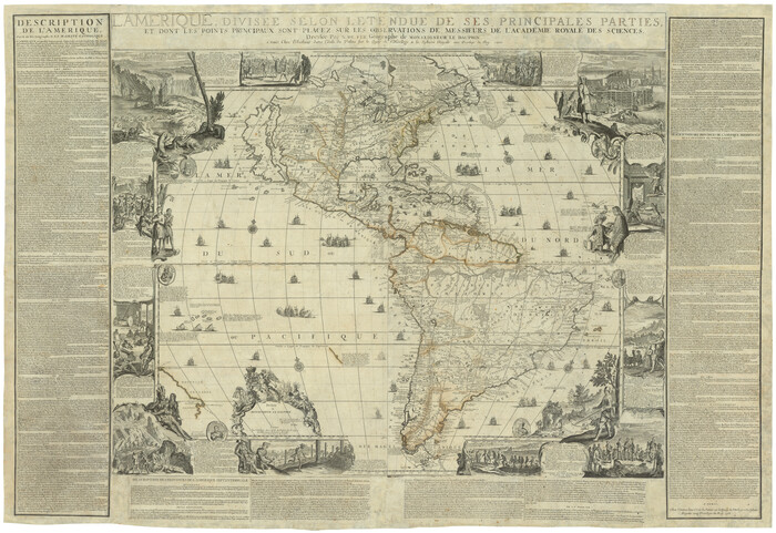
L'Amerique, divisée selon l[']etendue de ses principales parties, et dont les points principaux sont placez sur les observations de messieurs de l'Academie Royale des Sciences
Print $40.00
- Digital $50.00
L'Amerique, divisée selon l[']etendue de ses principales parties, et dont les points principaux sont placez sur les observations de messieurs de l'Academie Royale des Sciences
1705
Size: 44.9 x 65.4 inches
95688
Novissima et Accuratissima Totius Americae Descriptio

Print $20.00
- Digital $50.00
Novissima et Accuratissima Totius Americae Descriptio
1677
Size: 20.9 x 25.0 inches
93819
Nova Totivs Americae Descriptio

Print $20.00
- Digital $50.00
Nova Totivs Americae Descriptio
1666
Size: 21.2 x 24.3 inches
93818
Americae Nova Descriptio

Print $20.00
- Digital $50.00
Americae Nova Descriptio
1663
Size: 14.5 x 18.0 inches
95708
A New, Plaine, and Exact map of America : described by N.I. Visscher, and don into English, enlarged, and corrected, according to I. Blaeu, with the habits of the countries, and the manner of the cheife Citties, the like never before

Print $20.00
- Digital $50.00
A New, Plaine, and Exact map of America : described by N.I. Visscher, and don into English, enlarged, and corrected, according to I. Blaeu, with the habits of the countries, and the manner of the cheife Citties, the like never before
1658
Size: 16.4 x 20.9 inches
96787
Americae Nova Descriptio

Print $20.00
- Digital $50.00
Americae Nova Descriptio
1652
Size: 19.7 x 23.5 inches
95370
Americæ Nova Tabula

Print $20.00
- Digital $50.00
Americæ Nova Tabula
1633
Size: 15.3 x 18.7 inches
95827
Amèrica noviter delineata

Print $20.00
- Digital $50.00
Amèrica noviter delineata
1630
Size: 21.5 x 24.7 inches
93814
America with those known parts in that unknowne worlde both people and manner of buildings

Print $20.00
- Digital $50.00
America with those known parts in that unknowne worlde both people and manner of buildings
1626
Size: 17.1 x 22.2 inches
93816
America with those known parts in that unknowne worlde both people and manner of buildings

Print $20.00
- Digital $50.00
America with those known parts in that unknowne worlde both people and manner of buildings
1626
Size: 17.2 x 22.3 inches
93830
Americae nova Tabula

Print $20.00
- Digital $50.00
Americae nova Tabula
1617
Size: 16.0 x 21.5 inches
93813
Nova et Acurata Totius Americae Tabula

Print $40.00
Nova et Acurata Totius Americae Tabula
1608
Size: 40.8 x 56.5 inches
97019
The Dawn of Humans Peopling of the Americas
The Dawn of Humans Peopling of the Americas
2000
-
Size
31.3 x 20.5 inches
-
Map/Doc
96841
-
Creation Date
2000
Eastern South America Brazil, Paraguay, Uruguay, and the Guianas
Eastern South America Brazil, Paraguay, Uruguay, and the Guianas
1955
-
Size
29.8 x 41.2 inches
-
Map/Doc
92389
-
Creation Date
1955
Western Hemisphere
Print $20.00
- Digital $50.00
Western Hemisphere
1885
-
Size
12.2 x 9.0 inches
-
Map/Doc
93510
-
Creation Date
1885
Map of South America engraved to illustrate Mitchell's new intermediate geography
Print $20.00
- Digital $50.00
Map of South America engraved to illustrate Mitchell's new intermediate geography
1885
-
Size
12.2 x 9.0 inches
-
Map/Doc
93525
-
Creation Date
1885
Map of South America designed to accompany Smith's Geography of Schools
Print $20.00
- Digital $50.00
Map of South America designed to accompany Smith's Geography of Schools
1850
-
Size
12.0 x 9.8 inches
-
Map/Doc
93891
-
Creation Date
1850
Map of the United States, the British Provinces, Mexico &c. Showing the Routes of the U.S. Mail Steam Packets to California and a Plan of the Gold Region
Print $20.00
- Digital $50.00
Map of the United States, the British Provinces, Mexico &c. Showing the Routes of the U.S. Mail Steam Packets to California and a Plan of the Gold Region
1849
-
Size
19.6 x 26.6 inches
-
Map/Doc
95695
-
Creation Date
1849
Map of South America to illustrate Olney's school geography
Print $20.00
- Digital $50.00
Map of South America to illustrate Olney's school geography
1844
-
Size
12.1 x 9.5 inches
-
Map/Doc
93545
-
Creation Date
1844
Map of America

Print $20.00
- Digital $50.00
Map of America
1841
-
Size
21.6 x 24.9 inches
-
Map/Doc
95150
-
Creation Date
1841
Map of South America engraved to illustrate Mitchell's school and family geography
Print $20.00
- Digital $50.00
Map of South America engraved to illustrate Mitchell's school and family geography
1839
-
Size
11.8 x 9.5 inches
-
Map/Doc
93501
-
Creation Date
1839
The Continent and Islands of the West Indies
Print $20.00
The Continent and Islands of the West Indies
1804
-
Size
22.8 x 26.0 inches
-
Map/Doc
79318
-
Creation Date
1804
Carte d'Amerique, Divisee en ses Principaux Pays, Dressee sur les Memoires les plus recents, et sur differents Voyages, et assujettie aux observations Astronomiques de Mrs. de l'Academie Royale des Sciences
Print $40.00
- Digital $50.00
Carte d'Amerique, Divisee en ses Principaux Pays, Dressee sur les Memoires les plus recents, et sur differents Voyages, et assujettie aux observations Astronomiques de Mrs. de l'Academie Royale des Sciences
1787
-
Size
43.5 x 51.3 inches
-
Map/Doc
96430
-
Creation Date
1787
Bowles's New Pocket Map of America divided into its Provinces, Colonies, States, Governments &c. exhibiting the British and Spanish Empires therein; together with the Territories belonging to the French, Dutch, Danes & Portuguese
Print $20.00
- Digital $50.00
Bowles's New Pocket Map of America divided into its Provinces, Colonies, States, Governments &c. exhibiting the British and Spanish Empires therein; together with the Territories belonging to the French, Dutch, Danes & Portuguese
1784
-
Size
21.3 x 23.1 inches
-
Map/Doc
93838
-
Creation Date
1784
L'Amerique divisée en ses principales parties où sont distingués les uns des autres les estats selon quils appartiennent presentement aux differents souverains de l'Europe
Print $20.00
- Digital $50.00
L'Amerique divisée en ses principales parties où sont distingués les uns des autres les estats selon quils appartiennent presentement aux differents souverains de l'Europe
1752
-
Size
36.0 x 43.6 inches
-
Map/Doc
95188
-
Creation Date
1752
Carte Nouvelle de la Mer du Sud
Print $20.00
- Digital $50.00
Carte Nouvelle de la Mer du Sud
1730
-
Size
25.8 x 39.6 inches
-
Map/Doc
93824
-
Creation Date
1730
L'Amerique Meridionale, et Septentrionale Dressee selon les derniers Relations et suivant les Nouvelles Decouvertes
Print $20.00
- Digital $50.00
L'Amerique Meridionale, et Septentrionale Dressee selon les derniers Relations et suivant les Nouvelles Decouvertes
1726
-
Size
18.9 x 24.1 inches
-
Map/Doc
95134
-
Creation Date
1726
L'Amerique, divisée selon l[']etendue de ses principales parties, et dont les points principaux sont placez sur les observations de messieurs de l'Academie Royale des Sciences
Print $40.00
- Digital $50.00
L'Amerique, divisée selon l[']etendue de ses principales parties, et dont les points principaux sont placez sur les observations de messieurs de l'Academie Royale des Sciences
1705
-
Size
44.9 x 65.4 inches
-
Map/Doc
95688
-
Creation Date
1705
Novissima et Accuratissima Totius Americae Descriptio
Print $20.00
- Digital $50.00
Novissima et Accuratissima Totius Americae Descriptio
1677
-
Size
20.9 x 25.0 inches
-
Map/Doc
93819
-
Creation Date
1677
Nova Totivs Americae Descriptio
Print $20.00
- Digital $50.00
Nova Totivs Americae Descriptio
1666
-
Size
21.2 x 24.3 inches
-
Map/Doc
93818
-
Creation Date
1666
Americae Nova Descriptio
Print $20.00
- Digital $50.00
Americae Nova Descriptio
1663
-
Size
14.5 x 18.0 inches
-
Map/Doc
95708
-
Creation Date
1663
A New, Plaine, and Exact map of America : described by N.I. Visscher, and don into English, enlarged, and corrected, according to I. Blaeu, with the habits of the countries, and the manner of the cheife Citties, the like never before
Print $20.00
- Digital $50.00
A New, Plaine, and Exact map of America : described by N.I. Visscher, and don into English, enlarged, and corrected, according to I. Blaeu, with the habits of the countries, and the manner of the cheife Citties, the like never before
1658
-
Size
16.4 x 20.9 inches
-
Map/Doc
96787
-
Creation Date
1658
Americae Nova Descriptio
Print $20.00
- Digital $50.00
Americae Nova Descriptio
1652
-
Size
19.7 x 23.5 inches
-
Map/Doc
95370
-
Creation Date
1652
Americæ Nova Tabula
Print $20.00
- Digital $50.00
Americæ Nova Tabula
1633
-
Size
15.3 x 18.7 inches
-
Map/Doc
95827
-
Creation Date
1633
Amèrica noviter delineata
Print $20.00
- Digital $50.00
Amèrica noviter delineata
1630
-
Size
21.5 x 24.7 inches
-
Map/Doc
93814
-
Creation Date
1630
America with those known parts in that unknowne worlde both people and manner of buildings
Print $20.00
- Digital $50.00
America with those known parts in that unknowne worlde both people and manner of buildings
1626
-
Size
17.1 x 22.2 inches
-
Map/Doc
93816
-
Creation Date
1626
America with those known parts in that unknowne worlde both people and manner of buildings
Print $20.00
- Digital $50.00
America with those known parts in that unknowne worlde both people and manner of buildings
1626
-
Size
17.2 x 22.3 inches
-
Map/Doc
93830
-
Creation Date
1626
Americae nova Tabula
Print $20.00
- Digital $50.00
Americae nova Tabula
1617
-
Size
16.0 x 21.5 inches
-
Map/Doc
93813
-
Creation Date
1617
Nova et Acurata Totius Americae Tabula
Print $40.00
Nova et Acurata Totius Americae Tabula
1608
This map is an anonymous version of Blaeu's map of 1608 published in Venice in 1646.
-
Size
40.8 x 56.5 inches
-
Map/Doc
97019
-
Creation Date
1608
America

Print $20.00
- Digital $50.00
America
1607
-
Size
18.1 x 21.3 inches
-
Map/Doc
93811
-
Creation Date
1607