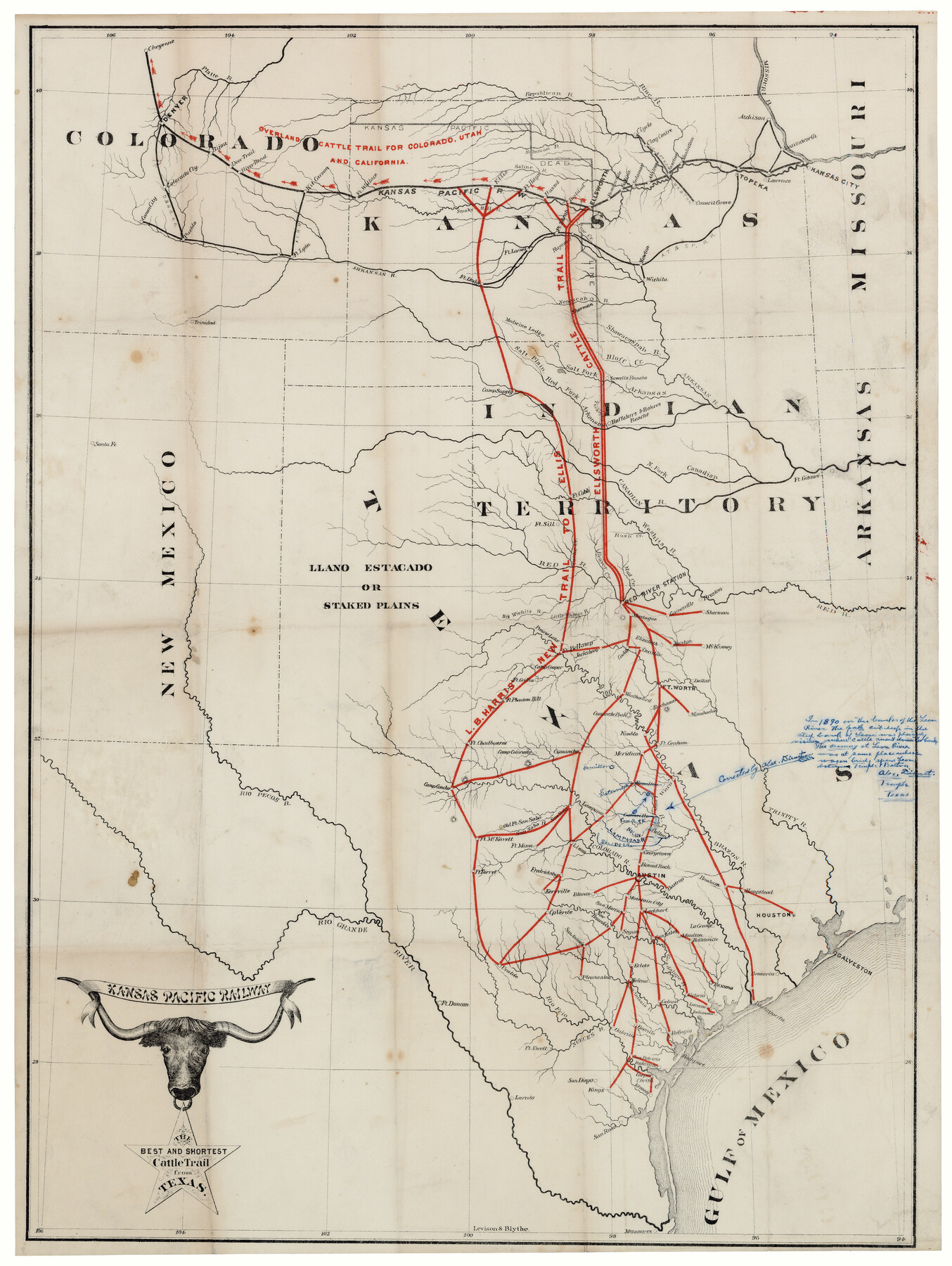
Guide map of the Great Texas Cattle Trail from Red River crossing to the Old Reliable Kansas Pacific Railway
-
Map/Doc
93938
-
Collection
Rees-Jones Digital Map Collection
-
Object Dates
1873 (Creation Date)
-
People and Organizations
Kansas Pacific Railway Co. (Publisher)
-
Subjects
Railroads State of Texas
-
Height x Width
23.4 x 17.6 inches
59.4 x 44.7 cm
-
Comments
Courtesy of the Rees-Jones Collection, Dallas, TX
Related maps

Part of: Rees-Jones Digital Map Collection
[Rand McNally's Indexed Map of Texas and Indian Territory]
![93992, [Rand McNally's Indexed Map of Texas and Indian Territory], Rees-Jones Digital Map Collection](https://historictexasmaps.com/wmedia_w700/maps/93992.tif.jpg)
Print $20.00
- Digital $50.00
[Rand McNally's Indexed Map of Texas and Indian Territory]
Size 26.0 x 20.6 inches
Map/Doc 93992
Sabine Pass and mouth of the River Sabine in the sea

Print $20.00
- Digital $50.00
Sabine Pass and mouth of the River Sabine in the sea
1842
Size 24.0 x 19.1 inches
Map/Doc 93766
A New Map of the United States upon which are delineated its vast works of internal communication, routes across the continent &c. showing also Canada and the Island of Cuba

Print $20.00
- Digital $50.00
A New Map of the United States upon which are delineated its vast works of internal communication, routes across the continent &c. showing also Canada and the Island of Cuba
Size 25.8 x 30.6 inches
Map/Doc 93996
Part of the boundary between the United States and Texas; north of Sabine River from the 36th to the 72nd mile mound

Print $3.00
- Digital $50.00
Part of the boundary between the United States and Texas; north of Sabine River from the 36th to the 72nd mile mound
1842
Size 12.0 x 8.8 inches
Map/Doc 93770
Chart of the Antarctic Continent shewing the icy barrier attached to it discovered by the U.S. Ex. Ex.

Print $20.00
- Digital $50.00
Chart of the Antarctic Continent shewing the icy barrier attached to it discovered by the U.S. Ex. Ex.
1840
Size 26.5 x 37.2 inches
Map/Doc 94058
A Map of the United States of Mexico as organized and defined by the several Acts of the Congress of that Republic

Print $20.00
- Digital $50.00
A Map of the United States of Mexico as organized and defined by the several Acts of the Congress of that Republic
1826
Size 23.9 x 31.2 inches
Map/Doc 93939
J. De Cordova's Map of the State of Texas Compiled from the records of the General Land Office of the State

Print $20.00
- Digital $50.00
J. De Cordova's Map of the State of Texas Compiled from the records of the General Land Office of the State
1867
Size 38.0 x 35.4 inches
Map/Doc 93759
Mapa de los Estados Unidos de Méjico, Segun lo organizado y definido por las varias actas del Congreso de dicha Republica: y construido por las mejores autoridades

Print $20.00
- Digital $50.00
Mapa de los Estados Unidos de Méjico, Segun lo organizado y definido por las varias actas del Congreso de dicha Republica: y construido por las mejores autoridades
1828
Size 30.2 x 42.2 inches
Map/Doc 93933
A New Map of Texas with the Contiguous American & Mexican States

Print $20.00
- Digital $50.00
A New Map of Texas with the Contiguous American & Mexican States
1839
Size 13.5 x 16.1 inches
Map/Doc 93941
Map of part of the island of Hawaii Sandwich Islands shewing the craters and eruption of May and June 1840 by the U.S. Ex. Ex.

Print $20.00
- Digital $50.00
Map of part of the island of Hawaii Sandwich Islands shewing the craters and eruption of May and June 1840 by the U.S. Ex. Ex.
1841
Size 18.4 x 25.9 inches
Map/Doc 94061
A map of the Anthracite Coal Fields of Pennsylvania embracing all of Schuylkill County and parts of Carbon, Luzerne, Columbia, Northumberland, Dauphin, and Lebanon Counties

Print $20.00
- Digital $50.00
A map of the Anthracite Coal Fields of Pennsylvania embracing all of Schuylkill County and parts of Carbon, Luzerne, Columbia, Northumberland, Dauphin, and Lebanon Counties
1863
Size 27.1 x 39.3 inches
Map/Doc 94054
Langtree's New Sectional Map of the State of Arkansas

Print $20.00
- Digital $50.00
Langtree's New Sectional Map of the State of Arkansas
Size 34.6 x 38.4 inches
Map/Doc 93987
You may also like
Coke County Rolled Sketch 19

Print $20.00
- Digital $50.00
Coke County Rolled Sketch 19
1954
Size 18.5 x 25.8 inches
Map/Doc 5519
Palo Pinto County Working Sketch 13

Print $20.00
- Digital $50.00
Palo Pinto County Working Sketch 13
1947
Size 27.4 x 24.2 inches
Map/Doc 71396
Crosby County Sketch File 36

Print $4.00
- Digital $50.00
Crosby County Sketch File 36
1935
Size 7.5 x 9.2 inches
Map/Doc 20108
Wharton County Working Sketch 6

Print $20.00
- Digital $50.00
Wharton County Working Sketch 6
1990
Size 24.7 x 21.1 inches
Map/Doc 72470
Motley County Sketch File 17 (N)

Print $4.00
- Digital $50.00
Motley County Sketch File 17 (N)
1913
Size 8.7 x 7.8 inches
Map/Doc 32060
Hemphill County Rolled Sketch 16

Print $40.00
- Digital $50.00
Hemphill County Rolled Sketch 16
1961
Size 65.4 x 26.9 inches
Map/Doc 9156
Panola County Working Sketch Graphic Index

Print $20.00
- Digital $50.00
Panola County Working Sketch Graphic Index
1947
Map/Doc 76660
Pecos County Rolled Sketch 85

Print $20.00
- Digital $50.00
Pecos County Rolled Sketch 85
1931
Size 36.7 x 24.4 inches
Map/Doc 7243
Cameron County Rolled Sketch 11

Print $20.00
- Digital $50.00
Cameron County Rolled Sketch 11
Size 26.7 x 34.0 inches
Map/Doc 11047
Edwards County Rolled Sketch 30

Print $20.00
- Digital $50.00
Edwards County Rolled Sketch 30
1980
Size 31.6 x 44.0 inches
Map/Doc 8848
Lampasas County Working Sketch 14

Print $20.00
- Digital $50.00
Lampasas County Working Sketch 14
1974
Size 23.4 x 21.8 inches
Map/Doc 70291
Travis County Boundary File 1

Print $8.00
- Digital $50.00
Travis County Boundary File 1
Size 9.0 x 14.6 inches
Map/Doc 59403