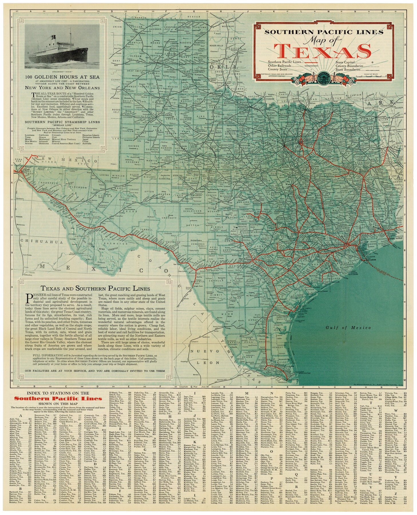
Southern Pacific Lines Map of Texas
-
Map/Doc
95774
-
Collection
Cobb Digital Map Collection
-
Object Dates
1928 (Creation Date)
-
People and Organizations
Passenger Traffic Dept., Southern Pacific Lines (Publisher)
The Whitney-Graham Co., Inc. (Printer)
-
Subjects
Railroads State of Texas Texas and Pacific Railroad
-
Height x Width
27.4 x 22.4 inches
69.6 x 56.9 cm
-
Medium
digital image
-
Comments
Courtesy of John & Diana Cobb.
To view information on verso, click "Download PDF" link above.
Part of: Cobb Digital Map Collection
Wayside Notes East Bound Along Sunset Route

Wayside Notes East Bound Along Sunset Route
1915
Map/Doc 96718
I. & G. N. - International and Great Northern R.R. - International Route - Galveston, Ft. Worth, Waco, Houston, Austin, Laredo, San Antonio

Print $20.00
- Digital $50.00
I. & G. N. - International and Great Northern R.R. - International Route - Galveston, Ft. Worth, Waco, Houston, Austin, Laredo, San Antonio
1905
Size 23.5 x 15.8 inches
Map/Doc 95778
San Benito, Texas in the Lower Rio Grande Valley [Frisco Lines]
![95795, San Benito, Texas in the Lower Rio Grande Valley [Frisco Lines], Cobb Digital Map Collection](https://historictexasmaps.com/wmedia_w700/maps/95795.tif.jpg)
Print $20.00
- Digital $50.00
San Benito, Texas in the Lower Rio Grande Valley [Frisco Lines]
1910
Size 19.5 x 19.4 inches
Map/Doc 95795
The Rand McNally New Commercial Atlas Map of Texas

Print $20.00
- Digital $50.00
The Rand McNally New Commercial Atlas Map of Texas
1915
Size 28.5 x 40.3 inches
Map/Doc 95862
[Map of Texas]
![96624, [Map of Texas], Cobb Digital Map Collection](https://historictexasmaps.com/wmedia_w700/maps/96624.tif.jpg)
Print $20.00
- Digital $50.00
[Map of Texas]
1869
Size 9.9 x 8.8 inches
Map/Doc 96624
Mileage Map - Best Roads of Texas showing principal cities, pole markings, road distances

Print $20.00
- Digital $50.00
Mileage Map - Best Roads of Texas showing principal cities, pole markings, road distances
1920
Size 12.8 x 16.2 inches
Map/Doc 95898
Map of the Lower Rio Grande Valley showing Alamo-Donna Farms

Print $20.00
- Digital $50.00
Map of the Lower Rio Grande Valley showing Alamo-Donna Farms
1920
Size 14.0 x 13.4 inches
Map/Doc 95801
The MKT - Texas Empire of the South

Print $20.00
- Digital $50.00
The MKT - Texas Empire of the South
1905
Size 18.6 x 40.6 inches
Map/Doc 97034

The Newest Land Of Promise - The Pecos Valley in Texas

Print $20.00
- Digital $50.00
The Newest Land Of Promise - The Pecos Valley in Texas
1900
Size 17.8 x 22.8 inches
Map/Doc 97037
A Few Things About Rice as grown along the line of the Sunset Route in Louisiana and Texas

A Few Things About Rice as grown along the line of the Sunset Route in Louisiana and Texas
1904
Map/Doc 96724
Sectional Map of Texas traversed by the Southern Pacific Lines and connections

Print $20.00
- Digital $50.00
Sectional Map of Texas traversed by the Southern Pacific Lines and connections
1916
Size 20.6 x 22.3 inches
Map/Doc 95800
You may also like

Madison County Working Sketch 8

Print $4.00
- Digital $50.00
Madison County Working Sketch 8
Size 22.4 x 28.8 inches
Map/Doc 70770
Upton County Sketch File 43

Print $22.00
- Digital $50.00
Upton County Sketch File 43
1988
Size 11.4 x 8.8 inches
Map/Doc 38920
Bandera County Working Sketch 40

Print $20.00
- Digital $50.00
Bandera County Working Sketch 40
1977
Size 29.9 x 23.7 inches
Map/Doc 67636
Kerr County Working Sketch 27

Print $4.00
- Digital $50.00
Kerr County Working Sketch 27
1970
Size 25.4 x 20.8 inches
Map/Doc 70058
Concho County Sketch File 5

Print $2.00
- Digital $50.00
Concho County Sketch File 5
1858
Size 8.1 x 7.4 inches
Map/Doc 82974
Matagorda County Rolled Sketch 16A

Print $20.00
- Digital $50.00
Matagorda County Rolled Sketch 16A
Size 23.6 x 41.1 inches
Map/Doc 6683
Kinney County Sketch File 26

Print $20.00
- Digital $50.00
Kinney County Sketch File 26
1928
Size 20.4 x 18.8 inches
Map/Doc 11945
Foard County Sketch File 8

Print $6.00
- Digital $50.00
Foard County Sketch File 8
Size 10.5 x 11.8 inches
Map/Doc 22810
[West and North lines of the Panhandle]
![90576, [West and North lines of the Panhandle], Twichell Survey Records](https://historictexasmaps.com/wmedia_w700/maps/90576-1.tif.jpg)
Print $20.00
- Digital $50.00
[West and North lines of the Panhandle]
1885
Size 22.0 x 32.1 inches
Map/Doc 90576
![90328, [Block B9], Twichell Survey Records](https://historictexasmaps.com/wmedia_w700/maps/90328-1.tif.jpg)
Rusk County Working Sketch 27

Print $20.00
- Digital $50.00
Rusk County Working Sketch 27
Size 35.6 x 29.3 inches
Map/Doc 63663