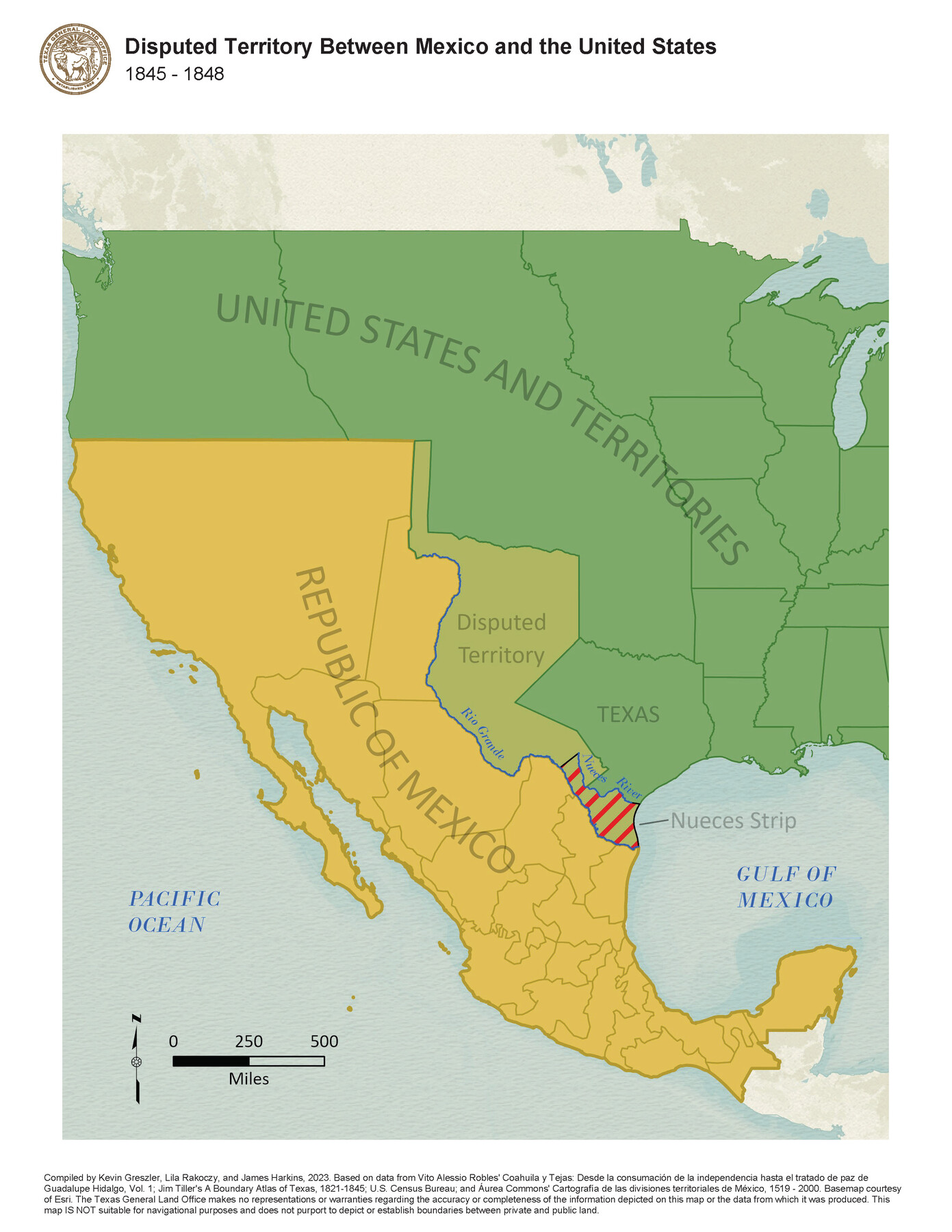
Disputed Territory Between Mexico and the United States
1845-1848
-
Map/Doc
97129
-
Collection
GIS Educational Maps
-
Object Dates
2023 (Creation Date)
-
People and Organizations
Kevin Greszler (Compiler)
Lila Rakoczy (Compiler)
James Harkins (Compiler)
-
Subjects
Geographic Information System Mexico United States Military
-
Height x Width
11.0 x 8.5 inches
27.9 x 21.6 cm
-
Medium
pdf
-
Comments
See "Northern Mexico Campaign of the U.S. - Mexico War, 1846-1847" (97152) and “Disputed Territory Between Mexico and the United States, 1845 – 1854” (97251) for additional maps in this series.
Related maps
Northern Mexico Campaign of the U.S. - Mexico War

Northern Mexico Campaign of the U.S. - Mexico War
2023
Size 8.5 x 11.0 inches
Map/Doc 97152
Disputed Territory Between Mexico and the United States

Disputed Territory Between Mexico and the United States
2024
Size 10.7 x 7.9 inches
Map/Doc 97251
Part of: GIS Educational Maps
General Range of Indigenous Tribes and Language Families in Texas

General Range of Indigenous Tribes and Language Families in Texas
2022
Size 8.5 x 11.0 inches
Map/Doc 97100
Military Reconstruction Districts

Military Reconstruction Districts
2024
Size 8.5 x 11.0 inches
Map/Doc 97345
Yellow Fever Deaths in the United States

Yellow Fever Deaths in the United States
2022
Size 8.5 x 11.0 inches
Map/Doc 97093
The Dust Bowl: Severe Drought During the Depression

The Dust Bowl: Severe Drought During the Depression
2022
Size 8.5 x 11.0 inches
Map/Doc 97095

Texas Population Distribution in Cities, per the U.S. Census of 1910

Texas Population Distribution in Cities, per the U.S. Census of 1910
2022
Size 11.0 x 8.5 inches
Map/Doc 97092
Northern Mexico Campaign of the U.S. - Mexico War
Northern Mexico Campaign of the U.S. - Mexico War
2023
Size 8.5 x 11.0 inches
Map/Doc 97152

United States Population Distribution by County and Territory, per the U.S. Census of 1900

United States Population Distribution by County and Territory, per the U.S. Census of 1900
2025
Size 8.5 x 11.0 inches
Map/Doc 97481

Events of the Texas Revolution

Events of the Texas Revolution
2023
Size 11.0 x 8.5 inches
Map/Doc 97189
Primary Transportation Routes through Mexican Texas

Primary Transportation Routes through Mexican Texas
2024
Size 11.0 x 8.5 inches
Map/Doc 97463
You may also like
Hale County Sketch File 11

Print $8.00
- Digital $50.00
Hale County Sketch File 11
1899
Size 11.1 x 8.5 inches
Map/Doc 24739
Harris County Historic Topographic 13

Print $20.00
- Digital $50.00
Harris County Historic Topographic 13
1915
Size 29.1 x 22.6 inches
Map/Doc 65823
El Paso County Working Sketch 48

Print $20.00
- Digital $50.00
El Paso County Working Sketch 48
1987
Size 32.7 x 29.4 inches
Map/Doc 69070
Gulf of Mexico

Print $20.00
- Digital $50.00
Gulf of Mexico
1946
Size 36.2 x 43.7 inches
Map/Doc 73550
Hutchinson County Rolled Sketch 37A

Print $40.00
- Digital $50.00
Hutchinson County Rolled Sketch 37A
1950
Size 26.0 x 51.1 inches
Map/Doc 9247
Nueces County NRC Article 33.136 Location Key Sheet

Print $20.00
- Digital $50.00
Nueces County NRC Article 33.136 Location Key Sheet
1975
Size 27.0 x 22.8 inches
Map/Doc 77033
Ellis County Boundary File 4

Print $14.00
- Digital $50.00
Ellis County Boundary File 4
Size 14.2 x 8.6 inches
Map/Doc 52983
Bexar County Working Sketch 19

Print $20.00
- Digital $50.00
Bexar County Working Sketch 19
1982
Size 41.8 x 41.7 inches
Map/Doc 67335
Lampasas County Sketch File 12

Print $8.00
- Digital $50.00
Lampasas County Sketch File 12
1874
Size 6.0 x 7.9 inches
Map/Doc 29422
Sectional map of Texas traversed by the Missouri, Kansas & Texas Railway, showing the crops adapted to each section, with the elevation and annual rainfall

Print $20.00
- Digital $50.00
Sectional map of Texas traversed by the Missouri, Kansas & Texas Railway, showing the crops adapted to each section, with the elevation and annual rainfall
1904
Size 21.7 x 22.6 inches
Map/Doc 95814
Harris County Historic Topographic 27

Print $20.00
- Digital $50.00
Harris County Historic Topographic 27
1915
Size 19.8 x 23.5 inches
Map/Doc 65838
Concho County Rolled Sketch 26

Print $20.00
- Digital $50.00
Concho County Rolled Sketch 26
1979
Size 15.1 x 18.1 inches
Map/Doc 5558