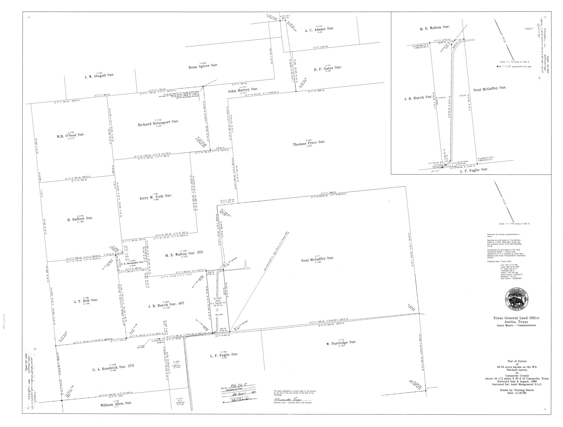
Comanche County Rolled Sketch 2
Plat of survey of 29.76 acres known as the W.D. Twichell survey
-
Map/Doc
10299
-
Collection
General Map Collection
-
Object Dates
1989/4/18 (Creation Date)
1989/4/28 (File Date)
-
People and Organizations
Elisandro Leos (Surveyor/Engineer)
Sterling Harris (Draftsman)
-
Counties
Comanche
-
Subjects
Surveying Rolled Sketch
-
Height x Width
36.9 x 48.6 inches
93.7 x 123.4 cm
-
Medium
mylar, print
-
Scale
1" = 144 varas = 400 feet
Part of: General Map Collection
Galveston Bay

Print $20.00
- Digital $50.00
Galveston Bay
1907
Size 40.6 x 34.4 inches
Map/Doc 69871
Flight Mission No. CRK-3P, Frame 66, Refugio County

Print $20.00
- Digital $50.00
Flight Mission No. CRK-3P, Frame 66, Refugio County
1956
Size 18.6 x 22.4 inches
Map/Doc 86908

Stonewall County Sketch File 18-1

Print $8.00
- Digital $50.00
Stonewall County Sketch File 18-1
1905
Size 11.3 x 8.6 inches
Map/Doc 37284
Throckmorton County Working Sketch 2

Print $20.00
- Digital $50.00
Throckmorton County Working Sketch 2
1919
Size 20.9 x 16.9 inches
Map/Doc 62111
Flight Mission No. DQN-3K, Frame 64, Calhoun County

Print $20.00
- Digital $50.00
Flight Mission No. DQN-3K, Frame 64, Calhoun County
1953
Size 16.2 x 16.1 inches
Map/Doc 84355
Flight Mission No. DQO-3K, Frame 39, Galveston County

Print $20.00
- Digital $50.00
Flight Mission No. DQO-3K, Frame 39, Galveston County
1952
Size 18.8 x 22.5 inches
Map/Doc 85080
Fort Bend County State Real Property Sketch 14

Print $40.00
- Digital $50.00
Fort Bend County State Real Property Sketch 14
1985
Size 36.7 x 35.6 inches
Map/Doc 61688
Pecos County Rolled Sketch 42

Print $20.00
- Digital $50.00
Pecos County Rolled Sketch 42
1909
Size 19.6 x 41.0 inches
Map/Doc 7220
Map of the Mississippi River from its Source to the Mouth of the Missouri

Print $20.00
- Digital $50.00
Map of the Mississippi River from its Source to the Mouth of the Missouri
1810
Size 10.4 x 31.3 inches
Map/Doc 95153
Flight Mission No. DQN-5K, Frame 78, Calhoun County

Print $20.00
- Digital $50.00
Flight Mission No. DQN-5K, Frame 78, Calhoun County
1953
Size 18.6 x 22.3 inches
Map/Doc 84411
Flight Mission No. DQO-2K, Frame 96, Galveston County

Print $20.00
- Digital $50.00
Flight Mission No. DQO-2K, Frame 96, Galveston County
1952
Size 18.8 x 22.4 inches
Map/Doc 85023
You may also like
Lee County Working Sketch 16

Print $20.00
- Digital $50.00
Lee County Working Sketch 16
1982
Size 20.5 x 13.5 inches
Map/Doc 70395
[Subdivision of Blk. M]
![90406, [Subdivision of Blk. M], Twichell Survey Records](https://historictexasmaps.com/wmedia_w700/maps/90406-1.tif.jpg)
Print $20.00
- Digital $50.00
[Subdivision of Blk. M]
Size 17.7 x 24.6 inches
Map/Doc 90406
General Highway Map, Irion County, Texas

Print $20.00
General Highway Map, Irion County, Texas
1940
Size 18.3 x 24.8 inches
Map/Doc 79138
Presidio County Working Sketch 94

Print $20.00
- Digital $50.00
Presidio County Working Sketch 94
1976
Size 40.6 x 32.1 inches
Map/Doc 71771
Travis County Working Sketch 38

Print $20.00
- Digital $50.00
Travis County Working Sketch 38
1974
Size 17.5 x 34.8 inches
Map/Doc 69422
Colorado County Sketch File 16

Print $4.00
- Digital $50.00
Colorado County Sketch File 16
Size 8.2 x 10.3 inches
Map/Doc 18945
Hall County Sketch File 32a

Print $56.00
- Digital $50.00
Hall County Sketch File 32a
1911
Size 14.4 x 8.6 inches
Map/Doc 24846
Plat of Resurvey of Sections 4, 9, 10 and 23, T. 5S., R. 13W., of the Indian Meridian, Oklahoma

Print $4.00
- Digital $50.00
Plat of Resurvey of Sections 4, 9, 10 and 23, T. 5S., R. 13W., of the Indian Meridian, Oklahoma
1917
Size 18.0 x 22.6 inches
Map/Doc 75143
Real County Working Sketch 24

Print $20.00
- Digital $50.00
Real County Working Sketch 24
1946
Size 17.4 x 22.5 inches
Map/Doc 71916
[Blocks S and H1]
![91436, [Blocks S and H1], Twichell Survey Records](https://historictexasmaps.com/wmedia_w700/maps/91436-1.tif.jpg)
Print $20.00
- Digital $50.00
[Blocks S and H1]
Size 23.0 x 10.2 inches
Map/Doc 91436
Map of Nacogdoches County

Print $20.00
- Digital $50.00
Map of Nacogdoches County
1881
Size 24.0 x 21.3 inches
Map/Doc 4602
Val Verde County Sketch File Z16

Print $20.00
- Digital $50.00
Val Verde County Sketch File Z16
1905
Size 21.4 x 20.9 inches
Map/Doc 12557