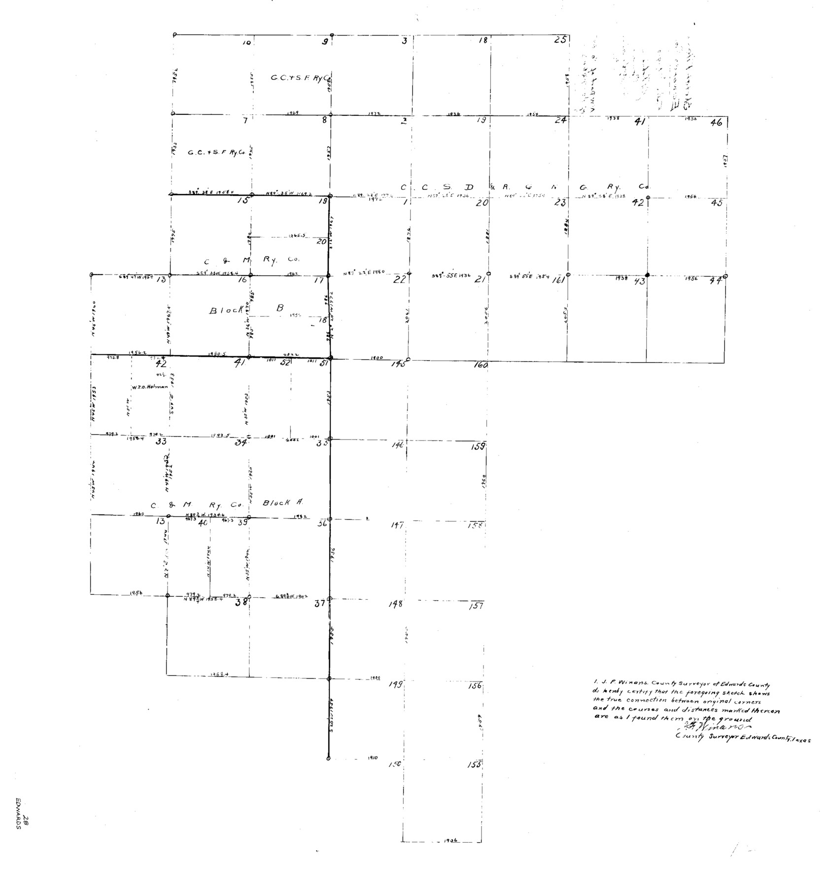
Edwards County Sketch File 28
NW part of Co. - parts of CCSDR&NG Blk. & Blks. A & B
-
Map/Doc
11431
-
Collection
General Map Collection
-
Object Dates
1919/8/9 (File Date)
-
People and Organizations
J.F. Winans (Surveyor/Engineer)
-
Counties
Edwards
-
Subjects
Surveying Sketch File
-
Height x Width
27.3 x 25.6 inches
69.3 x 65.0 cm
-
Medium
paper, photocopy
Part of: General Map Collection
[Drawings of individual counties for Pressler and Langermann's 1879 Map of Texas]
![[Drawings of individual counties for Pressler and Langermann's 1879 Map of Texas]](https://historictexasmaps.com/wmedia_w700/maps/4865.tif.jpg)
Print $20.00
- Digital $50.00
[Drawings of individual counties for Pressler and Langermann's 1879 Map of Texas]
1878
Size 27.3 x 38.1 inches
Map/Doc 4865
Motley County Working Sketch Graphic Index

Print $20.00
- Digital $50.00
Motley County Working Sketch Graphic Index
1966
Size 42.3 x 33.3 inches
Map/Doc 76650
Houston Ship Channel, Alexander Island to Carpenter Bayou

Print $40.00
- Digital $50.00
Houston Ship Channel, Alexander Island to Carpenter Bayou
1989
Size 35.4 x 49.3 inches
Map/Doc 69915
Matagorda County Working Sketch 27

Print $20.00
- Digital $50.00
Matagorda County Working Sketch 27
1979
Size 19.0 x 14.3 inches
Map/Doc 70885
Intrenched depot of the army of occupation at Point Isabel, Texas

Print $20.00
- Digital $50.00
Intrenched depot of the army of occupation at Point Isabel, Texas
1846
Size 17.0 x 25.2 inches
Map/Doc 72922
Ward County Rolled Sketch 9

Print $40.00
- Digital $50.00
Ward County Rolled Sketch 9
1936
Size 51.5 x 41.9 inches
Map/Doc 10105
Amistad International Reservoir on Rio Grande 71a

Print $20.00
- Digital $50.00
Amistad International Reservoir on Rio Grande 71a
1949
Size 28.4 x 39.6 inches
Map/Doc 73359
Franklin County Working Sketch 2

Print $20.00
- Digital $50.00
Franklin County Working Sketch 2
1953
Size 33.3 x 29.9 inches
Map/Doc 69240
Greer County Sketch File 7

Print $40.00
- Digital $50.00
Greer County Sketch File 7
Size 12.8 x 17.5 inches
Map/Doc 24526
Liberty County Working Sketch 65

Print $20.00
- Digital $50.00
Liberty County Working Sketch 65
1970
Size 27.6 x 47.3 inches
Map/Doc 70525
Ward County Rolled Sketch 10

Print $20.00
- Digital $50.00
Ward County Rolled Sketch 10
1936
Size 24.4 x 35.7 inches
Map/Doc 8155
Brooks County Rolled Sketch 14

Print $20.00
- Digital $50.00
Brooks County Rolled Sketch 14
Size 28.4 x 32.8 inches
Map/Doc 5339
You may also like
Kent County Boundary File 4b

Print $36.00
- Digital $50.00
Kent County Boundary File 4b
Size 14.2 x 8.7 inches
Map/Doc 55847
Flight Mission No. BRA-3M, Frame 119, Jefferson County

Print $20.00
- Digital $50.00
Flight Mission No. BRA-3M, Frame 119, Jefferson County
1953
Size 18.5 x 22.2 inches
Map/Doc 85393
Railroad Track Map, H&TCRRCo., Falls County, Texas

Print $4.00
- Digital $50.00
Railroad Track Map, H&TCRRCo., Falls County, Texas
1918
Size 11.6 x 18.3 inches
Map/Doc 62855
Runnels County Boundary File 1b

Print $24.00
- Digital $50.00
Runnels County Boundary File 1b
Size 15.7 x 8.3 inches
Map/Doc 58514
Mappa Geographica Americae Septentrionalis: ad emendatiora exemplaria adhuc edita jussu Acad. Reg. Scient. Et eleg. Litt. Descripta.

Print $20.00
- Digital $50.00
Mappa Geographica Americae Septentrionalis: ad emendatiora exemplaria adhuc edita jussu Acad. Reg. Scient. Et eleg. Litt. Descripta.
1753
Size 14.9 x 17.4 inches
Map/Doc 88882
General Highway Map, El Paso County, Texas

Print $20.00
General Highway Map, El Paso County, Texas
1940
Size 18.4 x 24.7 inches
Map/Doc 79084
Kendall County Boundary File 2

Print $4.00
- Digital $50.00
Kendall County Boundary File 2
Size 10.2 x 8.2 inches
Map/Doc 55746
Burnet County Boundary File 7

Print $36.00
- Digital $50.00
Burnet County Boundary File 7
Size 14.0 x 8.5 inches
Map/Doc 50893
Flight Mission No. CRK-8P, Frame 106, Refugio County

Print $20.00
- Digital $50.00
Flight Mission No. CRK-8P, Frame 106, Refugio County
1956
Size 18.3 x 22.1 inches
Map/Doc 86967
Map of Ramsey State Farm

Print $20.00
- Digital $50.00
Map of Ramsey State Farm
1934
Size 30.3 x 38.0 inches
Map/Doc 94284
Foard County Working Sketch 5b

Print $20.00
- Digital $50.00
Foard County Working Sketch 5b
Size 18.4 x 24.2 inches
Map/Doc 69196
Mills County Working Sketch 7

Print $20.00
- Digital $50.00
Mills County Working Sketch 7
1914
Size 12.8 x 13.0 inches
Map/Doc 71037