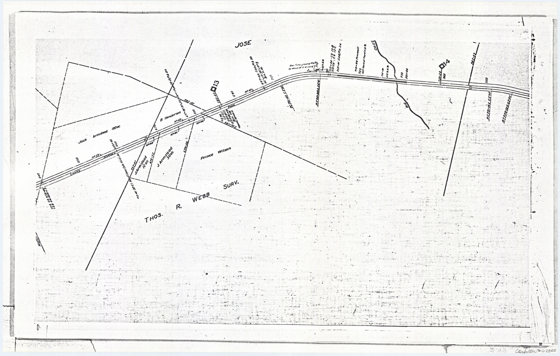
Railroad Track Map, H&TCRRCo., Falls County, Texas
Right of Way and Track Map
K-7-79 flat folder
-
Map/Doc
62855
-
Collection
General Map Collection
-
Object Dates
1918 (Creation Date)
-
Counties
Falls
-
Subjects
Railroads
-
Height x Width
11.6 x 18.3 inches
29.5 x 46.5 cm
-
Comments
Operated by the Texas and New Orleans Railroad Company, Waco Branch.
Part of: General Map Collection
Sutton County Sketch File X

Print $24.00
- Digital $50.00
Sutton County Sketch File X
1915
Size 14.3 x 8.8 inches
Map/Doc 37451
Portion of States Submerged Area in Matagorda Bay

Print $20.00
- Digital $50.00
Portion of States Submerged Area in Matagorda Bay
1919
Size 16.8 x 17.2 inches
Map/Doc 2949
Flight Mission No. DIX-10P, Frame 80, Aransas County

Print $20.00
- Digital $50.00
Flight Mission No. DIX-10P, Frame 80, Aransas County
1956
Size 18.8 x 22.4 inches
Map/Doc 83941
Flight Mission No. DAG-23K, Frame 181, Matagorda County

Print $20.00
- Digital $50.00
Flight Mission No. DAG-23K, Frame 181, Matagorda County
1953
Size 18.7 x 22.4 inches
Map/Doc 86516
Culberson County Sketch File 42

Print $14.00
- Digital $50.00
Culberson County Sketch File 42
1966
Size 14.2 x 8.7 inches
Map/Doc 20322
Cottle County Sketch File G

Print $8.00
- Digital $50.00
Cottle County Sketch File G
Size 11.5 x 7.3 inches
Map/Doc 19447
Crane County Sketch File 20

Print $4.00
- Digital $50.00
Crane County Sketch File 20
1928
Size 14.4 x 9.0 inches
Map/Doc 19588
Live Oak County Working Sketch 15

Print $20.00
- Digital $50.00
Live Oak County Working Sketch 15
1952
Size 23.8 x 22.6 inches
Map/Doc 70600

Coke County Working Sketch Graphic Index

Print $20.00
- Digital $50.00
Coke County Working Sketch Graphic Index
1945
Size 38.9 x 41.5 inches
Map/Doc 76496
Amistad International Reservoir on Rio Grande 108

Print $20.00
- Digital $50.00
Amistad International Reservoir on Rio Grande 108
1950
Size 28.5 x 40.9 inches
Map/Doc 75539
Flight Mission No. BRA-7M, Frame 34, Jefferson County

Print $20.00
- Digital $50.00
Flight Mission No. BRA-7M, Frame 34, Jefferson County
1953
Size 18.6 x 22.3 inches
Map/Doc 85485
You may also like
Young County Sketch File 19

Print $34.00
- Digital $50.00
Young County Sketch File 19
Size 14.5 x 8.9 inches
Map/Doc 40887
San Jacinto River, Proposed Dam Site/Huntsville State Park

Print $6.00
- Digital $50.00
San Jacinto River, Proposed Dam Site/Huntsville State Park
1937
Size 30.2 x 26.6 inches
Map/Doc 65151
Starr County Sketch File 15

Print $10.00
- Digital $50.00
Starr County Sketch File 15
Size 12.1 x 7.4 inches
Map/Doc 36869
Val Verde County Working Sketch 87

Print $20.00
- Digital $50.00
Val Verde County Working Sketch 87
1973
Size 37.1 x 33.8 inches
Map/Doc 72222
New Map of the Mining Regions of Idaho and Montana showing the geographical positions of the Blackfoot, Owyhee & South Boise Mines and the various routes thereto

Print $20.00
- Digital $50.00
New Map of the Mining Regions of Idaho and Montana showing the geographical positions of the Blackfoot, Owyhee & South Boise Mines and the various routes thereto
Size 21.9 x 29.4 inches
Map/Doc 93991
Map from Corpus Christi to Matagorda Bays, Texas [Inset: Survey of the channel of Copono Bay]
![72974, Map from Corpus Christi to Matagorda Bays, Texas [Inset: Survey of the channel of Copono Bay], General Map Collection](https://historictexasmaps.com/wmedia_w700/maps/72974.tif.jpg)
Print $20.00
- Digital $50.00
Map from Corpus Christi to Matagorda Bays, Texas [Inset: Survey of the channel of Copono Bay]
1846
Size 18.3 x 27.5 inches
Map/Doc 72974
McCulloch County Rolled Sketch 7

Print $20.00
- Digital $50.00
McCulloch County Rolled Sketch 7
1982
Size 20.7 x 30.5 inches
Map/Doc 6718
Wood County Rolled Sketch 1

Print $40.00
- Digital $50.00
Wood County Rolled Sketch 1
1941
Size 53.2 x 43.8 inches
Map/Doc 10159
Bailey County Rolled Sketch 7

Print $40.00
- Digital $50.00
Bailey County Rolled Sketch 7
1941
Size 67.7 x 44.8 inches
Map/Doc 8438
Map of Tyler County

Print $20.00
- Digital $50.00
Map of Tyler County
1897
Size 42.2 x 39.2 inches
Map/Doc 63081
Reeves County Working Sketch 42

Print $20.00
- Digital $50.00
Reeves County Working Sketch 42
1973
Size 46.3 x 31.5 inches
Map/Doc 63485
General Highway Map, Walker County, Texas

Print $20.00
General Highway Map, Walker County, Texas
1961
Size 24.7 x 18.1 inches
Map/Doc 79698